Not all inhabitants of the Earth realize that largest metropolitan areas of the world accommodate more population than some countries. That is why all people should know before traveling to these settlements interesting information about them. If a person lives in a small town or village, then the information about these metropolitan areas may seem really incredible.
Unchanging leader
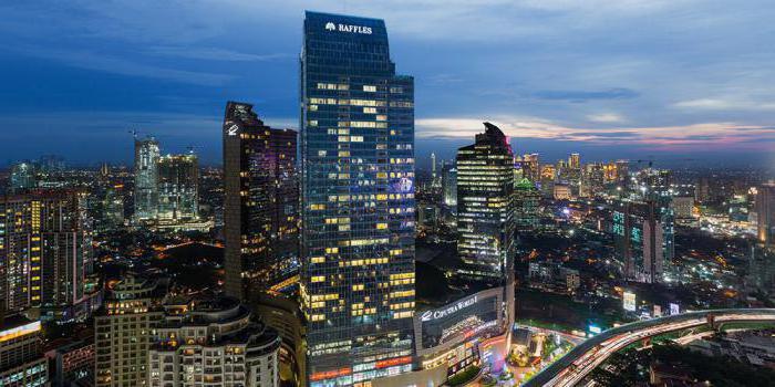
For six years now, the list of the largest metropolitan areas in the world has been headed by the capital of Japan, Tokyo. Its population in 2010 was more than thirty-seven million people. This huge metropolis has a density of 4,400 people per square kilometer.
In the Land of the Rising Sun, it is divided into different areas and is a city of many possibilities. It is worth noting that the agglomeration with Tokyo includes the port city of Yokohama, which has a population of more than three million, but even without it, the Japanese capital would take first place.
Second place
The list of the largest agglomerations in the world is continued by the capital of Indonesia, Jakarta. Its population by the beginning of 2017 is almost 32 million people. But the population density is twice that of Tokyo, and is 9,600 people per square kilometer.
This, incidentally, indicates a low standard of living. This agglomeration is located in the north-west of the island of Java, right on the seashore. This is one of its problems, because during the rainy season, many low-lying areas are flooded.
Despite the fact that Jakarta is located in the delta of two rivers, they are all heavily polluted. Approximately 70% of the body of water is completely unusable, another 20% is in average condition, and only ten percent is lightly polluted.
The history of this metropolis begins in 39 AD, when on the site of Jakarta, the local king founded his capital called Sunda Pura. The official foundation date is June 22, 1527, when the Portuguese took the settlement and renamed it.
Third and fourth place
Delhi lags behind the top two with 26 and a half million. The population density is 12 thousand people per square kilometer. It should be noted that in the 21st century the population of this agglomeration has doubled and continues to grow. People from all over the country come here in search of a better life.
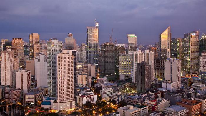
The fourth place in the list of the largest urban agglomerations in the world is assigned to the Philippine capital Manila. It would seem that on island nation there cannot be such a large metropolis, but recent studies confirm the opposite. The population density is even higher here and amounts to 13.6 thousand per square kilometer, and the total population is slightly more than 24 million.
The city is located on the island of Luzon, the climate is warm all year round. In addition, many sea and railway junctions intersect here.
Middle of the list
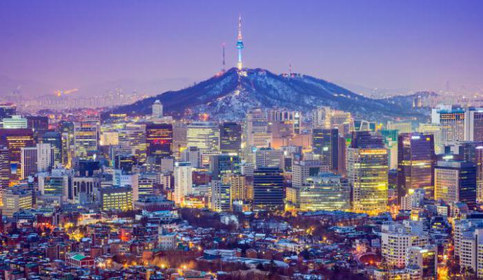
Seoul, the capital, is in fifth place among the largest metropolitan areas in the world South Korea... Together with this metropolis, the agglomeration also includes Incheon, which is considered the outport of the country's main city in the Yellow Sea.
The population of the Seoul metropolitan area is only 150 thousand less than in Manila. Its density is 8,800 people per square kilometer, which is quite a large figure.
Seoul is a high-tech center of the country, most people live in skyscrapers, and therefore there are so many people per unit area.
The sixth place is occupied by the port city of Karachi, located in the south of Pakistan. With the adjacent territories, the metropolis includes 23.5 million people, who are crowded into 1,010 square kilometers of area, which explains the high density indicator - 23 thousand.
Karachi is the largest port in the country, founded at the end of the eighteenth century.
Seventh and eighth place
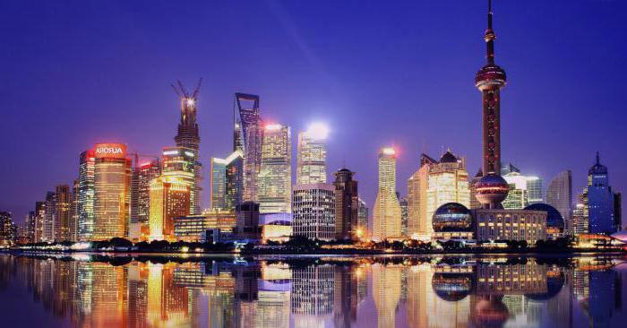
Shanghai could not be included in the list of the largest metropolitan areas and cities in the world. This huge Chinese city People's Republic located in the Yangtze River delta.
In this cultural and mall the country is home to 23.39 million people. The metropolis stretches over an area of almost 4,000 square kilometers, and therefore the population density here is only six thousand.
The climate here is mild, with warm winter, the geography of the location is favorable. Shanghai is not in vain a financial center, because many different corporations and research centers are concentrated here.
Eighth place in the list went to the metropolis of Mumbai, which is located on the shores of the Arabian Sea in India. In the top ten, this agglomeration has the highest population density (26 thousand) and covers an area of only 881 square kilometers.
The last metropolitan areas in the top ten
In ninth place in the category "The largest agglomerations and megacities of the world" - the city of which all inhabitants of the Earth dream, New York. Its territory with the surrounding lands occupies 11,875 km². Thanks to this, 21.5 million people have settled freely in this part of the world. The population density is only 1.7 thousand, which is the most favorable indicator.
New York is the cultural, tourist and financial center of the United States.
The list ends with Sao Paulo - a city in the southeast of Brazil. Its population with the suburbs is 20.8 million people in 2017. The density is 6.9 thousand people, which is not the worst indicator in the ranking.
All data are taken from the latest topographic materials and satellite images. Population, density and area are indicated from the information about the agglomerations of the cities listed.
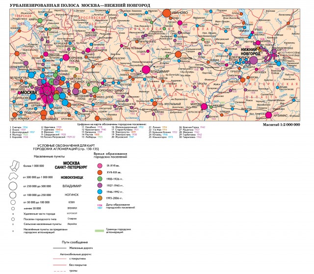
Led by the capital, the Moscow agglomeration is the largest and most complex among the agglomerations in Russia, unmatched in terms of territorial size and population, the number of cities and towns, and the variety of their types. First of all, it stands out for the power and role of the core. Moscow has an extremely strong impact on the surrounding area, showing a high demand for satellite cities. While urbanization in the country has slowed down without being completed, it continues intensively in the Moscow region, for which there are material, financial, organizational and, most importantly, demographic resources, which are in dire shortage in most regions of the Russian Federation.
At present, the territory of the Moscow agglomeration is at least 20 thousand km2, and the population is about 16 million people. The Moscow agglomeration numbers about 100 cities, including a dozen and a half in neighboring regions.
The main characteristic feature of the Moscow agglomeration is that it was here that a new type of city arose and developed - a science city. Even before the Great Patriotic War, prototypes of future technopolises appeared, for example, the city of Korolev (in those years Kaliningrad) - the center of rocketry, which later became the largest aerospace complex. There are about three dozen science cities in the Moscow agglomeration, almost half of the existing ones in Russia. Among them are centers of not only applied, but also fundamental science - Dubna, Pushchino, Protvino, Troitsk, Chernogolovka.
The Moscow agglomeration has a developed historical and cultural framework, the links of which are the ancient cities of Kolomna, Dmitrov, Volokolamsk, Borovsk, and others; famous monasteries, such as the Trinity-Sergius Lavra in Sergiev Posad, the Nikolo-Ugreshsky monastery in Dzerzhinsky, Joseph Volokolamsky near Volokolamsk, New Jerusalem in Istra. This also includes estates - literary nests and centers of arts, places of military glory associated with the events of the Patriotic War of 1812 and the Battle of Moscow in 1941-42. All this creates an amazingly spiritual region.
The Moscow agglomeration is also a recreational agglomeration, due to the saturation with institutions for treatment, recreation, and tourism. In terms of the total number of places in sanatoriums and other health-improving facilities, the Moscow region is not inferior.
Moscow agglomeration is a giant reservoir labor resources... Every day on weekdays, about 1,200 thousand people come to work and study in Moscow from the surrounding area, the counter flow reaches 400 thousand people.
The territorial structure of the Moscow agglomeration is distinguished by many characteristic features. Its frame is the radii of a branched transport hub, which has 11 railways and 13 highways, as well as the waterways of the Moskva River and the Moscow. The transport hub determines the configuration of the Moscow metropolitan area - a multi-beam star. Along some radii, almost continuous bands of settlement were formed for tens of kilometers, especially developed in the Ryazan, Yaroslavl, Vladimir directions.
About complexity territorial organization The Moscow agglomeration is evidenced by the formation in its composition of "daughter" agglomerations, the so-called agglomerations of the 2nd order. These are territorial groups of neighboring cities and towns, which are closely interconnected, united by common local problems, which are developing in different places, gravitating more towards the eastern part. In the central part of the Moscow agglomeration, these are the Noginsko-Elektrostalskaya, Podolsko-Klimovskaya, Lyuberetsko-Ramenskaya, Balashikhinsko-Reutovskaya, Khimkinsko-Zelenogradskaya, Dolgoprudnensko-Lobnenskaya agglomerations; on the periphery - Serpukhovsko-Chekhovskaya, Kashirsko-Stupinskaya, Kolomenskaya, Orekhovo-Zuevskaya, Obninsko-Narofominskaya. Some peripheral agglomerations of the 2nd order included settlements of neighboring regions. On the Kaluga direction, near the borders with the Moscow Region, a group of cities and settlements has formed, headed by Obninsk, with a total population of 240 thousand people. The Orekhovo-Zuevskaya agglomeration includes the cities of the Vladimir region - Pokrov, Petushki, Kosterevo. There is a convergence of the Moscow agglomeration with the agglomerations of Kaluga, Tver, Vladimir, Ryazan, Tula, which enhances the connectivity of the regions in Central Russia.
Russian metropolis
In Russia, there are still no conditions conducive to the formation of megalopolises - the most complex forms of urban settlement. However, in the middle part of Central Russia, a kind of urbanistic formation is developing in the form of a strip between Moscow and, filled with a significant number of cities and towns. This strip is approaching the state that gives reason to call it a metropolis.
The strip begins in the west with the giant Moscow agglomeration and ends in the east with the developed Nizhny Novgorod agglomeration, in which the number of inhabitants exceeds 2 million people.
The Moscow agglomeration, if we take into account the second-order agglomerations formed in its marginal zone, has an agglomeration radius exceeding 100 km, it comes into contact with the agglomerations of neighboring regional centers. Near Nizhniy Novgorod, in some of the most developed directions, the agglomeration radius reaches 100 km. The width of the strip connecting the agglomeration ends is approximately 20-40 km. Exactly in the middle of it is the bipolar Vladimir-Kovrov agglomeration, which includes about a dozen cities.
Urbanized education was formed on a territory with a long history. This is the cradle of the Russian state, the land of ancient opolii and cities, numerous nests of various handicrafts. Here the first areas of large-scale factory industry were formed, in which the textile industry prevailed in the past. The Moscow and Nizhny Novgorod agglomerations, and above all their centers, played a leading role in the years of industrialization and the scientific and technological revolution, were the pioneers of new industries and the creation of new types of technology.
Close internal ties have long been manifested, strengthening the economic and cultural fabric of the territory. In the era of industrialization, Nizhny Novgorod, developing in the image and likeness of Moscow, acted as its understudy, especially in such progressive industries as the automotive industry, machine tool building, aircraft construction, electrical engineering and radio electronics.
Handicraft trades and the large-scale industry that arose on their basis created conditions for the "ripening" of factory, factory, handicraft villages into cities. The leader in this process even before the October Revolution was Orekhovo-Zuevo, which by 1917, when it was given the status of a city, had 60 thousand inhabitants.
Among cities of similar origin, the share of monofunctional centers is high. These are cities, whose city-forming base is often made up of one enterprise. Such are Drezna, Yakhroma, Lakinsk, Sobinka (textile centers), Vorsma (production of tools), Bogorodsk (leather and shoe production). The cities have greatly expanded and strengthened their economic foundation - Vladimir, Kovrov, Noginsk, Balakhna, Pavlovo.
New cities are the centers of industries of the new century - high-quality metallurgy (Elektrostal), (Elektrogorsk), oil refining (Kstovo), instrument making (Raduzhny), motor engineering (Trans-Volga region). For science cities, especially widespread in the Moscow agglomeration, the basis is the triad: science - high-tech production (usually experimental with testing new samples) - higher education.
Moscow and Nizhny Novgorod agglomerations rush towards each other. They are both asymmetrical. At Moskovskaya, the eastern rays are more fully developed, at Nizhegorodskaya, the western ones. The eastern agglomeration ray ends at Kstovo, and the western reaches Gorokhovets in the Vladimir region.
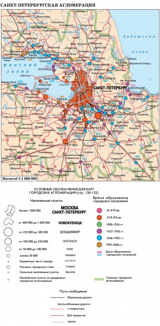
St. Petersburg agglomeration is a large urban agglomeration, the uniqueness of which is given by St. Petersburg - a great city, cultural capital Russia, in its historical part, is an example of urban planning art.
St. Petersburg is the only Russian center that began its existence with the simultaneous creation of satellite settlements in its surroundings: residences of rulers, fortresses, ports.
The peculiarity of the agglomeration is given by the seaside position. The agglomeration acquires a characteristic pattern following natural objects and landscapes. Along the full-flowing Neva, the Nevsky ray of settlement was formed, ending at Shlisselburg (64 km from) in front. The Karelian Isthmus, due to its natural conditions, abounds in beautiful lake-forest landscapes and overlooks the banks Lake Ladoga and Gulf of Finland, represents a vast recreational area and is almost part of the suburban area, being part of the agglomeration. The Karelian Isthmus, with its large recreational capacity, is a place for recreation, treatment, tourism and sports.
The recreational component is inherent in many cities of the St. Petersburg agglomeration, including those that perform other functions - port, industrial, scientific, administrative.
The agglomeration as a whole, like its core St. Petersburg, is multifaceted. The agglomeration comprises about 35 urban settlements, incl. 15 cities. Total population (at the beginning of 2006) - 5257 thousand people; St. Petersburg accounts for 87%. The share of the population of the satellite area is low. Among the cities and towns of the agglomeration there are many famous ones that occupy a prominent place in the history, economy, culture, and territorial organization of Russia. There are 8 cities and 21 urban-type settlements with a total population of 560 thousand people under the administrative subordination of Saint Petersburg. The cities of Kolpino, Sestroretsk, Zelenogorsk, Kronstadt, Lomonosov, Pavlovsk, Pushkin, Petrodvorets remain isolated, separated from the central city by significant spaces that are unlikely to be built up in the foreseeable future. Being within the administrative boundaries of St. Petersburg, they actually form the first (near) satellite zone in the agglomeration.
After the revolution, when former capital the empire was cut off from the traditional foreign raw materials and fuel bases, a system of satellite cities was created around Leningrad - production additions that provided its enterprises with electricity, fuel, metal, chemical raw materials... Power Plant Cities different types(thermal, hydraulic, nuclear) made up a "detachment" of power engineers. Currently, there is a development of port cities, intended, in particular, to serve the export of oil. St. Petersburg, being the largest scientific center, stimulated the emergence and development of science cities - centers that accelerate scientific and technological progress. Among them are Sosnovy Bor, born of the Leningrad nuclear power plant, Primorsk, Gatchina, Petrodvorets, Kolpino, etc.
In the conditions of the socio-economic crisis of the 1990s. The St. Petersburg agglomeration experienced significant difficulties, which resulted in a decline industrial production, a decline in research and recreational activities, in a consistent decline in population. In St. Petersburg (Leningrad) for 1989-1998. the number of residents decreased by 6.1%, while over the previous 10 years (1979–1989) it increased by 9.5%.
The decline in the number of residents continues. Affected by the lack of demographic resources in Russia.
However, the St. Petersburg agglomeration - the second in terms of potential in Russia - retains the dynamics of development. In the 1990s, the formation of new cities continued, new ports were built and are being built; the region of St. Petersburg attracts significant investments from domestic and foreign entrepreneurs, the possibilities of domestic and foreign tourism are expanding.
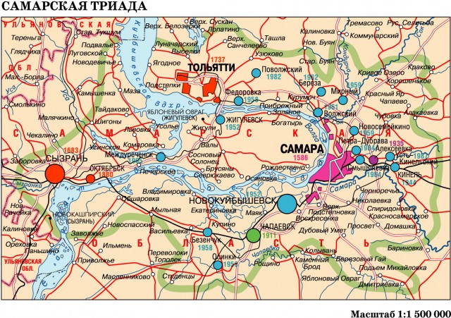
Samarskaya Luka is one of the most notable places on the Volga. Arcuate bend with tight turns, where the river changes direction by 90 °, skirting the Zhiguli mountains, juts out far to the east. At the extreme eastern part of the arc, Samara is located - the largest center, founded as a fortress city in 1586 shortly after the Kazan Khanate was annexed to the Moscow state. Two other bends of the bend are marked by pairs of cities: Togliatti - Zhigulevsk, Syzran - Oktyabrsk.
The three-center cluster of urban settlements - the Samara Triad - has almost 2.5 million urban residents. A little less than half falls on the share of Samara (46.8%). The distance between Samara and Togliatti is about 100 km. This is the closest convergence of the largest (over 500 thousand people) cities in Russia. Almost the same distance separates Togliatti and Syzran. Three agglomerations overlap with their edge parts.
Samara occupies an advantageous geographical position, in an area rich in energy resources and fertile soils.
Before the Great Patriotic War, Samara housed enterprises of the leading industries - aircraft building, machine tool building, instrument making. During the war Samara was the country's reserve capital. Samara has the largest number of residents in comparison with other cities of the Volga region. The largest multifunctional city, the center of culture, science, higher education, high-tech industry, Samara actively stimulated the emergence of satellite cities in its surroundings. Among them stand out: Novokuibyshevsk - the center of oil refining and petrochemistry; Chapaevsk, founded on the eve of the First World War, with several chemical enterprises; Kinel is a railway junction located east of Samara.
Togliatti is the largest of the Russian newly-built cities, the center of the automotive industry, the chemical industry, and the building materials industry; large river port, center of tourism and sports.
Togliatti is an agglomeration. The city line covers three geographically separate areas, united by urban systems of transport and engineering infrastructure. The largest district Avtozavodsky (435.2 thousand inhabitants) surpasses the other two combined - Central (city-forming base - mainly chemical plants) and Komsomolsky (river port, railway station, production of building materials).
Syzran is a city located 137 km from Samara and almost 100 km from Tolyatti. Syzran emerged in 1683 as a fortress on the Syzran defensive line. At present, Syzran is the center of mechanical engineering and the chemical industry, a large railway junction at the first crossing of the Volga in its middle reaches; the western gate of the agglomeration formation in the area. In recent years, production ties between Syzran and Togliatti have been strengthening.
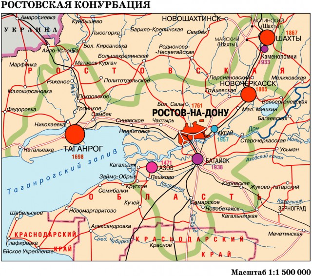
The polycentrism of urban education that has developed in the region of Rostov-on-Don allows us to call it a conurbation, not an agglomeration. In the territorial organization of the south of the European part of Russia, urban settlement, in the system of interregional ties, the area is quite remarkable. In these places, cities have emerged since ancient times. There is an archaeological reserve on the site near the mouth of the Don River ancient city Tanais. The current city of Azov had a string of predecessors located in the Middle Ages on the northern branch of the Great Silk Road.
Later, the confrontation between the Russian and Ottoman empires developed; sought to gain a foothold on the Black Sea and Azov coasts, to develop expansion to the Don and Volga. Therefore, she turned Azov into a formidable fortress and tenaciously held on to it. Peter I undertook the Azov campaigns to establish himself on the southern seas, founded in 1698 Taganrog - a fortress and a port. People thirsting for freedom from all over Russia fled to the Don. The capital of the Don Cossacks, Starocherkassk, was replaced by the city of Novocherkassk, specially built in 1805 as an administrative center. In the 2nd half of the 19th century. Donbass was quickly formed. Its eastern wing consistently occupied parts of the Don Cossack Region, turning the Cossack villages into coal mining centers. The most significant of them - the village of Grushevskaya in 1867 received city status (now the city of Shakhty).
From the first half of the nineteenth century. Rostov-on-Don (city since 1796), created on the site of the fortress of St. Dmitry of Rostov (founded in 1761), developed as the largest trade and industrial centre South Russia. Its importance increased after the connection by railways with Kharkov (1870), Voronezh (1871), Vladikavkaz (1875). The role of Rostov-on-Don was defined as the “Gateway to the Caucasus”.
According to the 1897 census, Rostov-on-Don exceeded Novocherkassk twice in terms of the number of inhabitants. In the 1920s it became administrative center Azov-Black Sea, then North Caucasian Territory, since 1937 - the center of the Rostov Region. Modern Rostov-on-Don is the largest cultural, scientific and industrial center, the most important transport hub. To a large extent, the functions of a transport hub are assigned to the satellite of Rostov-on-Don, the city of Bataysk (formed in 1936), located 15 km to the south, on the opposite bank of the Don. The second closest satellite, the industrial center Aksai, is located 18 km to the east (formed in 1957 from the village of Aksai).
The city of Novocherkassk, having lost administrative functions, has preserved cultural and educational, and has also turned into a large diversified industrial center. The city of Shakhty is the main industrial center of the Russian Donbass. For centuries, the city of Azov had a restless fate as a key fortress city, in late XIX v. was a posad. Now it is a multifunctional city, a sea and river port, a center of industry and tourism. The city of Taganrog is the second most populous city in the region and conurbation, the center of the northern Azov region. His industrial development contributed to the situation at the exit from the Donbass. Metallurgy, aircraft construction (designing seaplanes), and automobile construction are well developed in Taganrog. Taganrog is an important center of culture and education; city A.P. Chekhov.
Each of the cities of conurbation has a remarkable history, characteristic features, its own trajectory of development. In the center of the urban area, Rostov-on-Don stands out sharply, characterized by a special variety of functional structure and outstanding geographic location... Rostov-on-Don connects the coal-metallurgical Donbass with the Don and Kuban granaries, opens the way to the Caucasus and the Lower Volga.
Rostov-on-Don does not know any competitors and, despite its position "in the corner", is its recognized and natural socio-economic focus.
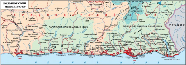
The city of Sochi has embraced the resort agglomeration with its urban boundaries, stretching along the Black Sea coast for 145 km from the Shepsi River in the north-west to the Psou River in the state and Georgia.
The agglomeration territory is 3506 km2 (three times more than Moscow), the number of inhabitants is 331.0 thousand people. The agglomeration of Sochi is the city of Sochi itself and the coastal settlements Magri, Makopse, Ashe, Lazarevskoye, Soloniki, Golovinka, Yakornaya Shchel, Vardane, Loo, Dagomys, Matsesta, Khosta, Adler, and in the mountains, an urban-type settlement Krasnaya Polyana ...
After the railway from Tuapse to Adler was continued in, the Sochi agglomeration found itself in a transport corridor. The railway and the previously laid Black Sea Highway served as the axes for the development of the agglomeration.
Sochi is a resort city. The introduction to resort activities took place in 1908, when the first-born sanatorium “Caucasian Riviera” was put into operation. The transformation into a mass resort took place in the 1930s. In a short time, sanatoriums, clinics, a complex of bathroom buildings in Matsesta, sea terminals in Sochi and Matsesta were built, an arboretum was created, Kurortny Avenue was laid, bank protection works were carried out, etc.
As a resort, Sochi is unique, due to a combination of several factors: mild climate, warm sea, sulfide-chloride-sodium waters of Matsesta, carbonic waters of Krasnaya Polyana, clayey ferruginous silts of the Imeretinskaya Bay (Adler region). Sochi's potential has not yet been fully utilized.
The agglomeration city of Sochi consists of 4 administrative districts: Lazarevsky, Central, Khostinsky and Adlerovsky. About 2/5 of the resident population is concentrated in the Central Region. The administration, the main cultural institutions are located here: an opera house, a philharmonic society, an art museum, a museum of Nikolai Ostrovsky, a circus, an arboretum, large hotels, as well as railway, sea and bus stations. A significant part of the multi-storey housing stock is located in the valley of the river. Sochi (New Sochi). There are also enterprises and production of building materials serving the needs of the resort - resort.
Adler is a transport hub, an international airport. The active use of the Adler coast for recreation began relatively recently. Unlike the Central District, where the share of sanatoriums is high, boarding houses prevail in Adler.
If at the initial stage of Sochi's development, preference was given to sanatoriums, then later on, much attention was paid to the construction of hotels, which, in particular, contributed to the development of the so-called "festival" activities - film festivals, song festivals, sports competitions and training camps, scientific conferences, business meetings, etc.
Krasnaya Polyana (formerly Romanovsk) is an urban-type settlement located in the valley of the river. Mzymta, 40 km north of Adler, with which it is connected by a highway. Krasnaya Polyana is a climatic and balneological resort, a center for tourism and skiing.
The development of Sochi as the capital of the 2014 Winter Olympic Games will make it possible to carry out a radical reconstruction of the agglomeration and to make fuller use of its unique potential. The construction of a bypass road will be completed, the level of improvement will increase, sports facilities (over 200 facilities), hotels, boarding houses, residential buildings will be commissioned, the airport will expand. The "wings" of the agglomeration - Lazarevsky and Adlerovsky districts of Sochi, Krasnaya Polyana - will receive preferential development.
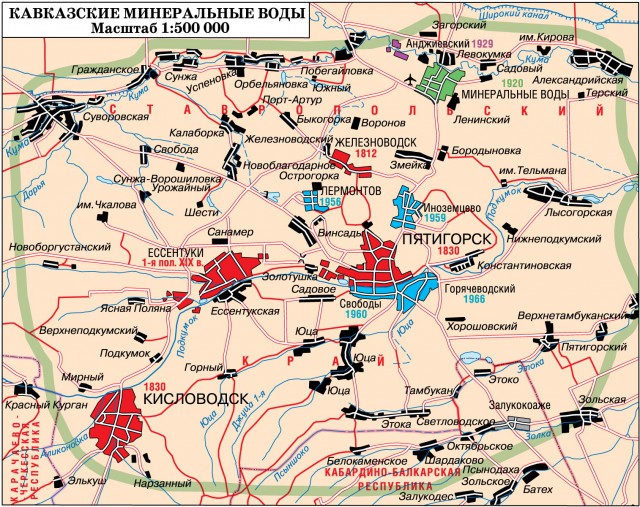
Caucasian Mineral Waters, a constellation of famous resorts, is located in the Central Ciscaucasia, partly on the plain, partly in the foothills of the Greater Caucasus. Laccolith mountains, various mineral springs, mud of the lake. Tambukan (near Pyatigorsk). Since July 1992, Caucasian Mineralnye Vody has been given the status of a specially protected ecological resort area.
The agglomeration of settlements of the Caucasian Mineral Waters has developed as a system of interconnected centers that complement each other. It consists of 6 cities and 4 urban-type settlements, and also includes rural settlements subordinate to the city administrations of Mineralnye Vody, Pyatigorsk and Kislovodsk. The largest urban settlement - Pyatigorsk - accounts for 27.0% of the total population of the district.
Mineral springs have been studied since the end of the 18th century. In 1803, by the decree of Alexander I, the Kislovodsk region was declared a resort area.
In 1830 Pyatigorsk and Kislovodsk became cities. The development of resorts was constrained by the remoteness from the central regions of the country and the lack of convenient communications. An impetus for development was given by the commissioning of the Vladikavkaz railway. The construction at the end of the 19th century was of great importance. highway Mineralnye Vody - Kislovodsk and a railway line parallel to it.
All resort cities have a pivotal function - healing, but at the same time they have different specialization and different place therapeutic function in the national economic structure.
Pyatigorsk has occupied a central place for a long time. In addition to sanatoriums and other medical institutions in Pyatigorsk there are scientific research institutes of balneology and physiotherapy, the Pedagogical Institute. The share of industry not related to the needs of resorts (agricultural engineering) is significant, which narrows the possibilities for the development of Pyatigorsk as a resort.
Kislovodsk takes the lead among the resort cities of the Caucasian Mineral Waters in terms of the number of health resorts and the flow of treatment and vacationers served. It is not only a balneological resort using its own narzans and delivered by pipeline (from the Nagutskoye deposit), but also a mountain climatic resort. Kislovodsk is famous for its climate, an abundance of sunny days, wonderful parks, and a variety of landscapes. There is a philharmonic society, a theater, museums of the history of resorts and the history of cosmonautics, dachas - the museums of the artist Yaroshenko and the singer Shalyapin. Kislovodsk is a tourism center. From it there is a road to Karachaevsk - Teberda - Dombay.
Essentuki is a city since 1917, a balneological and mud resort specializing in the treatment of the digestive system and metabolic disorders. It has a unique balneological base.
Zheleznovodsk has been a city since 1917, but medical procedures have been carried out since 1812. It is located on the southern slopes of Mount Zheleznaya.
The city of Mineralnye Vody has a special role. Having received city status in 1920, it performs the duties of the main transport hub, manages the flow of tourists. Here is one of the largest in Russia international airports... 1960-1970s the construction materials industry developed in the city.
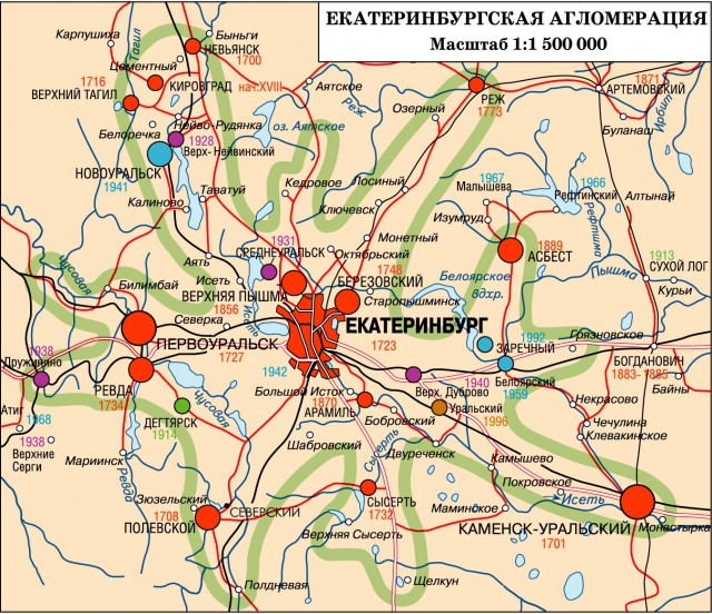
Agglomeration occupies central position on . The center of the agglomeration is the city of Yekaterinburg, founded in 1723 as the administrative and economic center of the mining industry in the Urals, this is the first city in the agglomeration area from the time of its formation. The city of Nevyansk received the rights of a city in 1917, although as a settlement at the plant ("city-plant") arose in 1700.
In the years of the pre-war five-year plans, 6 settlements became cities, during the war - 2, in the post-war period - 8. Along with the cities that had deep historical roots, on “ clean place»New-built cities appeared: the well-known atomic city and the science city of Novouralsk, the science city of Zarechny at the first in the Urals Beloyarsk NPP, and the power engineering city of Sredneuralsk. In the post-Soviet era, no new cities were formed.
The supremacy of Yekaterinburg is determined by a higher share in its national economic structure of the "upper floors": science (a group of research institutes with recognized achievements, reputable scientific schools), higher education (a galaxy of universities, including several universities and academies), and cultural institutions (theaters, museums).
The Yekaterinburg agglomeration is multi-beam, has a form characteristic of the agglomerations that have developed in a branched transport hub (Yekaterinburg has 7 railway directions).
Some of the cities of the agglomeration are centers for the extraction of ore and non-metallic minerals (Berezovsky, Degtyarsk, Asbest, Verkhnyaya Pyshma). The largest copper-smelting plant in Kirovgrad operates at its ores. Feature- availability in territorial structure agglomeration of nests of urban settlements - geographically close groups of cities and urban-type settlements (Pervouralsk – Revda – Degtyarsk, Zarechny – Beloyarsky, Sysert – Verkhnyaya Sysert, etc.). The conglomeration inherent in mining regions in general is widespread.
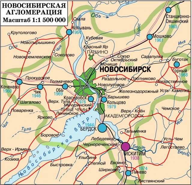
Novosibirsk is the largest city in Siberia, almost last year the existence of the USSR, one and a half million inhabitants - could not form a developed agglomeration. Within the 100-kilometer zone of its influence, there are only 3 cities and 9 urban-type settlements. The total number of urban settlements together with Novosibirsk is more than 1600 thousand people. It accounts for 82.5% of the population.
All cities and towns received their current status in the 20th century. The growth of the Novosibirsk Trans-Siberian Railway that arose at the crossing of the Ob River was phenomenal. By 1926, he outstripped all the cities of Siberia and the Far East in terms of the number of inhabitants, except for Omsk. By the 1939 census, it grew 3.4 times (Omsk - 1.8) and became the leading city in the Asian part of Russia.
The advantages of the economic and geographical location of Novosibirsk: the location of the city at the eastern edge of the Barabinskaya steppe, the proximity of another granary of Siberia - the Steppe Altai and, which is especially important - the location at the exit from Kuzbass - the main coal and metallurgical base of the eastern regions of Russia.
All the main things that determine the role of the main center of the agglomeration, Novosibirsk seeks to concentrate within its city limits or in the immediate vicinity of it. This is partly due to the underdevelopment of the zone of satellite cities.
The largest satellite of Novosibirsk is the city of Berdsk (10 km to the south), in which electrical engineering enterprises occupy a leading place in the city-forming base. The city of Iskitim is the center of the building materials industry, the city of Ob specializes in. To the south of the center of Novosibirsk there is a triad of Akademgorodoks: the Russian Academy of Sciences (Akademgorodok - Novosibirsk region), the Siberian Branch of the Academy of Medical Sciences (Koltsovo) and the Academy of Agricultural Sciences (Krasnoobsk).
In recent decades, not a single new urban settlement has appeared in the Novosibirsk agglomeration. Despite the inclusion of suburban settlements in the city limits of Novosibirsk, for 1989-2006. the number of residents decreased by almost 40 thousand people.
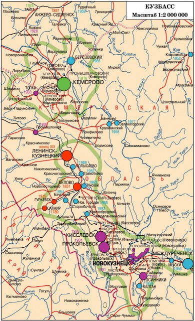
The axis of urbanization stretches for hundreds of kilometers from Anzhero-Sudzhensk to the city of Tashtagol in Gornaya Shoria. In its middle part, an urbanized strip has formed, the cities and towns of which form a chain of agglomerations headed by the cities of Kemerovo, Leninsk-Kuznetskiy and Novokuznetsk. This is a kind of coal and metallurgical Kuzbass megalopolis with a length of about 400 km and a population of over 2 million people.
Novokuznetsk surpasses regional center Kemerovo. The advantages of Kemerovo are that it has a more developed industrial structure and is the center of Southern Kuzbass, which is very promising for the development of industry, and mountain tourism, thanks to the recreational resources of Gornaya Shoria.
The creation of a galaxy of Kuzbass cities in a short time took place in difficult conditions of industrialization, wartime and post-war economic recovery. At all these stages, there was a significant shortage of time and money, which explains the ecological disadvantage, insufficient improvement, the scatteredness of cities and towns, and the monotony of development. The cities of Kuzbass are young, but in many respects are made according to the old models.
The system of Kuzbass cities is intertwined with close production ties. Novokuznetsk metallurgical enterprises receive iron ore from Tashtagol, electricity from Kaltan. Zinc concentrate is delivered to Belovo from Salair. The basis of the national economic complex, as before, is coal - the bread of the industry.
Having been for ten years an area of attraction for migrants from all over the country, Kuzbass is now losing its population. All the cities of Kuzbass have reduced their population: Anzhero-Sudzhensk, Kiselevsk, Leninsk-Kuznetsky, Prokopyevsk, Osinniki have lost about 1/5 of their inhabitants since 1989. The stability of Kemerovo is explained by the inclusion of suburban settlements in its urban boundaries.
Kuzbass possesses a variety of mineral, forest, water, land and recreational resources. Kuzbass has two exits to the Transsib, direct exits to Altai and Eastern Siberia... However, the remoteness from foreign markets, due to the location in the interior of the continent, hinders the development of the basic industry.
I would be grateful if you share this article on social networks:
Site search.
Introduction
1 The concept of urban agglomeration
1.1 Hierarchy of urban systems
1.2 Spatial structure of urban agglomerations
1.3 Ways of agglomeration formation
1.4 Problems of big cities
2 The largest urban agglomerations in the world
2.1 Overseas Europe
2.2 Overseas Asia
2.3 USA and Latin America
Conclusion
List of used literature
Introduction
The city is one of the greatest and most complex creations of man. The appearance of cities - the stone chronicle of mankind - keeps the memory of major events world history. Cities are the main arena of political, economic, social processes taking place in modern world, a place of concentration of the greatest values created by human labor.
How and why do cities grow? How to uncover mysterious secret spatial concentration of cities at different points the globe? What is their internal structure? These questions concern all people and constitute the professional task of the geographical study of cities.
The aim of the course work is to consider the largest urban agglomerations, ways of their formation and development.
The tasks of this work are:
· In identifying the features of the structure and formation of the largest urban agglomerations;
· In considering the hierarchy of urban systems;
· In defining the problems of cities.
Urban agglomerations are a developing form of settlement and territorial organization of the economy. Concentrating in themselves a huge scientific, technical, production and socio-cultural potential, they are the main bases for accelerating scientific and technological progress and have a great impact on the vast territories surrounding them, therefore, their study is especially important today.
The course work consists of an introduction, two chapters, a conclusion and a bibliography and includes one table. It is written on 28 pages. The first chapter contains four subchapters, the second three. Eight different sources of literature were used to write this work.
1
.
Urban agglomeration concept
In the historical evolution of settlement forms, the traditional types of settlements - urban and rural settlements developing relatively autonomously - are increasingly being replaced by new "group" forms of highly concentrated settlement, which are formed when settlements are closely located and intense ties are formed between them. These are urban agglomerations - rapidly developing clusters of settlements around the world, often consisting of a dozen, and sometimes hundreds of settlements, including rural settlements closely related to each other. There is no single terminology for these population clusters. Along with the term "urban agglomeration" they use the terms "local settlement systems", "areas of large cities", "group settlement systems", "constellation of cities".
The most common term "urban agglomeration" is not entirely apt. In industrial technology, agglomeration means "the formation of large lumps (agglomeration) from fine ore and silty materials by sintering." In the economic literature, the term "agglomeration" is characterized by territorial overlapping, concentration of industrial enterprises in one place.
The term "agglomeration" in relation to settlement was introduced by the French geographer M. Rouge, according to which agglomeration occurs when the concentration of urban activities goes beyond the administrative boundaries and spreads to neighboring settlements.
In the domestic literature, the concept of urban agglomeration was used, and quite widely, already in the 10s and 20s, although under different names: this is also the “economic district of the city” by A.A. Kruber, and the "agglomeration" of M.G. Dikansky, and the "economic city" of V.P. Semenov-Tyan-Shanskiy.
There are many definitions of the word "agglomeration".
According to N.V. Petrov, urban agglomerations are compact clusters of geographically concentrated cities and other populated areas, which, in the process of their growth, converge (sometimes grow together) and between which various economic, labor, cultural and everyday relationships are strengthened.
E.N. Pertsik gives a different definition: urban agglomeration is a system of geographically close and economically interconnected populated areas, united by stable labor, cultural, domestic and industrial ties, a common social and technical infrastructure, - qualitatively new form settlement, it arises as a successor of the city in its compact (autonomous, point) form, a special product of modern urbanization. And large urban agglomerations are the most important areas in which progressive industries, administrative and economic, scientific and design organizations, unique institutions of culture and art, and the most qualified personnel are concentrated.
The boundaries of the urban agglomeration are mobile in time due to a change in the most important parameter of the agglomeration - the distance of daily movement from the place of residence to the places of employment: within the framework of the spatial self-organization of these movements, their distance increases in proportion to the increase in the speed of means of transport, and the time spent increases insignificantly.
The development of urban agglomerations is characterized by: the buildup of gigantic urban clusters, including non-stop growing and spreading cores, involving ever new territories in their orbit, the concentration of large masses of the population in them; the rapid development of suburbs and the gradual (although not always clearly traceable) redistribution of the population between city centers and suburban areas; the involvement of the rural population in non-agricultural labor, especially in urban areas; pendulum migrations and systematic movement of people within agglomerations to work, to places of study, cultural services and recreation, acquiring an unprecedented scale.
E.N. Pertsik proposes various criteria for urban agglomerations: urban density and building continuity; the presence of a large city center (as a rule, with a population of at least 100 thousand people); the intensity and distance of labor and cultural and domestic trips; the proportion of non-agricultural workers; the proportion of those working outside the place of residence; the number of satellite urban settlements and the intensity of their ties with the city center; the number of telephone calls with the center; industrial relations; communications on social, household and technical infrastructure (unified engineering systems for water supply, power supply, sewerage, transport, etc.). In some cases, a combination of signs is taken as a criterion, in others it is guided by one of them (for example, the boundaries of agglomeration are distinguished by 1.5- or 2-hour isochrones of labor movements from the city center).
1.1 Hierarchy of urban systems
Cities grow and develop. In some cases, megacities are formed from formerly small cities, the population of which is often more than 8 million people.
The evolution of forms of settlement under the influence of development processes and concentration of production leads to the convergence and coalescence of agglomerations, the formation of megalopolises - urbanized zones of the supra-aglomeration level, including vast territories (city - agglomeration - urbanized zone - urbanized area - megalopolis).
So, there are five main hierarchically subordinate forms of urbanized settlement (according to Yu.L. Pivovarov):
1. A compact city (in its traditional form) is the main element of settlement at the initial stages of urbanization of a country or region. According to the "Dictionary of General Geographic Terms", a city is understood as: "a set of monasteries, incorporated (ie registered as a unit of account) and managed by the mayor or aldermen." A city in Denmark is understood as a settlement with more than 250 inhabitants, in Japan - 30 thousand, in Russia from 5 to 12 thousand inhabitants.
2. Agglomeration - (from Latin agglomero - I add, accumulate) an elementary form of developed group settlement. It represents a cluster around the center (big city) of closely spaced urban and rural settlements, united by intense and stable ties. Agglomeration is considered by us for areas with great development potential as a stage form in the transition from an autonomous city to more complex forms of settlement.
3. An urbanized (metropolitan) area is the main structural element of settlement in the future. It means a relatively vast area, the core of which is usually made up of several agglomerations with their surroundings, united by common functional and morphological features. This socio-spatial form of settlement is based on a comprehensive planning of vast territories, on specialization and a clear allocation of functional zones. It includes the metropolitan area itself and the territory of the vast metropolitan region.
4. The urbanized zone is the largest link (combining several elements) in the promising spatial structure of the country's settlement. This is an area with a high density of urban settlements and a large proportion of the urban population. The urbanized zone is distinguished by the intensity of the development of urban settlements (and not by their number).
5. Megalopolis (from the Greek megalu - large, polis - city) is the largest form of settlement. These are vast urbanized zones of a strip-like configuration, which are formed as a result of the actual splicing of many neighboring agglomerations of different ranks. Typically, these urbanized lanes stretch along the most important transport highways and polyhighways, or a kind of economic axes.
1.2 Spatial structure of urban agglomerations
In urban agglomerations, with significant features of their planning structure and administrative division, fundamentally different zones can be distinguished, which allows us to consider these zones as typical and functionally regular formations.
1. The historical core of the city is a very small area, in which the most outstanding architectural and historical buildings, administrative, cultural and business centers of the agglomeration are concentrated. Such are the historical center of Moscow within the Garden Ring; the central core of London, including the City, Westminster and the West End; South part County of New York, occupying the territory of Manhattan Island. The historical centers of European capitals are characterized by very dense buildings that have developed over many centuries; a radial-circular layout inherited from the historical past or close to it; gradual displacement of residential development by buildings of government or business significance; extensive development of commercial establishments, hotels, museums, etc. The daytime population dramatically exceeds the nighttime population.
2. The central zone of the city includes, in addition to the historical core, the intensively built-up area closest to it, formed in European capitals mainly until the middle of the 19th century. and later surrounded by a ring railways, stations, industrial areas. In the following decades, this zone was significantly transformed, but to a large extent it still retains the old layout, there are many valuable structures. With the growth and territorial expansion of the administrative, business, cultural, scientific, and commercial functions of the capitals, this zone is increasingly being rebuilt, undergoing redevelopment, and acquiring the functions of a center. TO central regions capitals can be attributed: the central planning Zone of Moscow, the Paris department within the old fortress walls, the central zone of St. Petersburg to the Obvodny Canal, including Vasilievsky Island, Petrograd side. The central zones as a whole are characterized by a significant excess of the daytime population over the nighttime population, and a gradual decrease in the resident population.
3. The outer zone of the city in Moscow and St. Petersburg is administratively included in the city, in Paris it is allocated into the so-called “first urban belt”, in London, the outer zone of “old suburbs” can be attributed to the peripheral zone of the city. At present, the bulk of the population of capital cities is concentrated in peripheral zones, and as the entire territory of these zones is filled with solid buildings, their population grows, but then it shows an objective tendency to decline and expansion outside the city limits.
4. A large city (or the core of a metropolitan area, an urbanized agglomeration zone, a city with the first inner belt of a suburban zone). An example can be Petersburg with settlements subordinated to the city, Paris "agglomeration within wide boundaries", "Greater London" with the first inner metropolitan belt, Greater New York - the urbanized area of New York.
5. The suburban area forms, together with the city, a broader formation, which can be regarded as an agglomeration. These are the Moscow and Petersburg metropolitan areas, the London metropolitan area. It is important to distinguish between the territories of agglomerations, covering the capital cities and their suburban areas, the "core of agglomerations", including the capital cities and inner rings of suburban areas. Conventionally, these "cores" of agglomerations could be called "Big City" (Greater Moscow, Greater London, Greater New York). All agglomerations as a whole are characterized by: a sequential shift of the population from the inner rings of the agglomeration to the outer ones; strong development of pendulum migrations, gradually fading with distance to the periphery of the agglomeration and especially intense in its core, the development of satellite cities in the outer rings.
6. Outer zone of the capital region. The capital region should be understood as a zone that is subject to the direct and intense influence of the capital and requires targeted urban planning measures associated with it; however, the most important urban planning parameter that constructs the agglomeration, the daily pendulum labor movements, ceases to operate. The outer zone is becoming an arena for major events for the development of city systems - "counter-magnets", which help to unload the agglomeration, to create recreational areas, agricultural bases, etc. The metropolitan regions may include: the Moscow region - Moscow and the Moscow region; London - southeast of England; New York Region - the borough of the New York City District Planning Association.
1.
3Ways of agglomeration formation
Formation of an agglomeration "from the city".
Upon reaching a certain "threshold" (which is strongly influenced by the size of the city, its national economic profile, local and regional natural conditions) a dynamically developing large city feels an increasing need for new development resources - territories, water supply sources, infrastructure. However, within the city limits, they are depleted or close to depletion. Further continuous (perimeter) expansion of the urban area is associated with negative consequences.
Therefore, the center of gravity of development is objectively shifting to the area surrounding the city. Satellite settlements appear (most often on the basis of existing small settlements) of various profiles. In essence, these are parts of a big city, which, becoming the center of an agglomeration, creates a system of complements and partners. On the one hand, everything that does not fit in the city "spills out" beyond its borders. On the other hand, much of what strives for it from the outside settles on the outskirts. Thus, the agglomeration is formed by two opposite streams.
In some cases, the objects that make up the city-forming satellite base ( industrial enterprises, test sites, research laboratories, design bureaus, marshalling yards, warehouses, etc.) seem to branch off from the existing national economic complex of the city. In others, they arise in response to the needs of the city and the country, are created by the efforts of various sectors of the economy, being attracted by favorable conditions for development in the area surrounding the city.
Development of the agglomeration "from the district"
... It is typical for resource zones, in places of development of the extractive industry, where during the development large deposits usually a group of settlements of similar specialization arises. Over time, one of them, located more conveniently than others in relation to the area of settlement and having better conditions for development, attracts objects of non-local significance. It becomes an organizational, economic and cultural center, science and design and engineering are developing in it, enterprises of the construction industry and transport organizations are concentrated. All this determines its priority growth and gradual rise in territorial group settlements, which over time acquire the role of satellites in relation to it.
This is how the city appears, which takes over the functions of the center of the agglomeration. Under the influence of the main "profession", his companions have a closed labor balance: the inhabitants of the village work mainly at the enterprise located here, in the village. Therefore, labor relations with the city-center in the formations of this type are weaker than in the agglomerations developing “from the city”. With the further growth and strengthening of the multifunctionality of the city-center, the differences between the agglomerations of the two described categories are weakening, although there remains a significant difference in the nature of the territory used.
1.4 Problems of big cities
The widespread and uncontrollable growth of large cities and agglomerations makes us think about the internal patterns and causes of this phenomenon, identify the shortcomings of this form of settlement and evaluate its true merits.
The most important disadvantages of large cities and, to a certain extent, large urban agglomerations are well known:
1. Unusual complication of transport problems. The saturation of large cities with road transport increases, while the speed of its movement decreases in inverse proportion.
2. There is a rise in the cost of engineering equipment;
3. Pollution environment, primarily air. According to chemical studies, the plume of polluting and thermal effects of large cities can be traced at a distance of up to 50 km, covering an area of 800-1000 km2
... At the same time, the most active impact is manifested on an area that exceeds the area of the city itself by 1.5-2 times. Such cities as Los Angeles, Mexico City, not accidentally received the nickname "smogopolis". It is no coincidence that a comic advice to the townspeople was born: "Let everyone breathe less and only in case of emergency."
4. Removal of the population of large cities from nature.
5. Big cities"Suck" the productive forces from small and medium-sized cities.
There is no doubt that humanity in the future will be able to find a solution to the transport and environmental problems of the largest cities. Moreover, the point of view seems to be justified that it is the high concentration productive forces in the largest cities will allow solving these problems most effectively, since with such a concentration, the greatest capital investment for these purposes.
2
.Largest urban agglomerations in the world
In 1950, of the 30 largest metropolitan areas, 20 were located in Europe, North America, Japan and only 10 in developing countries. In 1990, the ratio changes: out of 30 agglomerations, only 9 are located in developed countries, and 21 - in developing countries. Milan, Berlin, Philadelphia, Petersburg, Detroit, Naples, Manchester, Birmingham, Frankfurt, Boston, Hamburg are leaving the list of the largest metropolitan areas. This list is supplemented by Seoul, Jakarta, Delhi, Manila, Karachi, Lagos, Istanbul, Lima, Tehran, Bangkok, Dhaka (Table 1).
Table 1. The thirty largest urban areas in the world in 1990
Urban agglomeration |
a place | million people | |
| 1 | 2 | 3 | |
| Tokyo | 1 | 25,0 | |
| New York | 2 | 16,1 | |
| Mexico City | 3 | 15,1 | |
| Sao Paulo | 4 | 14,8 | |
| Shanghai | 5 | 13,5 | |
| Bombay (Mumbai) | 6 | 12,2 | |
| Los Angeles | 7 | 11,5 | |
| Beijing | 8 | 10,9 | |
| Calcutta | 9 | 10,7 | |
| Buenos Aires | 10 | 10,6 | |
| Seoul | 11 | 10,6 | |
| Osaka | 12 | 10,5 | |
| Rio de Janeiro | 13 | 9,5 | |
| Paris | 14 | 9,3 | |
| Tianjin | 15 | 9,3 | |
| Jakarta | 16 | 9,3 | |
| Moscow | 17 | 9,0 | |
| Cairo | 18 | 8,6 | |
| 1 | 2 | 3 | |
| Delhi | 19 | 8,2 | |
| Manila | 20 | 8,0 | |
| Karachi | 21 | 8,0 | |
| Lagos | 22 | 7,7 | |
| London | 23 | 7,3 | |
| Chicago | 24 | 6,8 | |
| Istanbul | 25 | 6,5 | |
| Lima | 26 | 6,5 | |
| Essen (Ruhr) | 27 | 6,4 | |
| Tehran | 28 | 6,4 | |
| Bangkok | 29 | 5,9 | |
| Dhaka | 30 | 5,9 | |
2.1 Overseas Europe
It is known from history that the first cities in Europe appeared in the era of antiquity. Then their number increased significantly during the Middle Ages. The number of big cities also grew; by the beginning of the 20th century, Europe Abroad concentrated 1/3 of all large cities in the world. It was this region that became the birthplace of urban agglomerations, of which there were about 400 in the early 1980s.
In Germany
most agglomerations stretch along a chain along the Rhine and its tributaries. Downstream is the largest Rhine-Ruhr polycentric agglomeration, in turn, consisting of 2 main parts - the Ruhr, stretching on the right bank of the Rhine from Deisburg to Dortmund through Essen and Bochum, and the Rhine, including primarily Dusseldorf, Cologne and Bonn. The population of this agglomeration is 10-11 million people.
Upstream of the Rhine is the Rhine-Main agglomeration, the core of which is Frankfurt am Main. Further upstream is the Rhine-Neckor agglomeration with the cities of Mannheim and Ludwigshafen.
In Great Britain
Among the agglomerations, the London one takes the leading place, the population of which, depending on how its borders are drawn, varies from 7.6 million to 12.1 million people. Eight satellite cities have been built in the vicinity of London. This is followed by Greater Birmingham (West Midlands) and Greater Manchester with a population of 3.2 and 2.6 million, respectively.
In France
allocate the Paris metropolitan area with a population of 11.3 million people. This capital is a large industrial center in which high-tech knowledge-intensive industries are widely represented, as well as the production of so-called "Parisian products" (clothing, jewelry, etc.). It is here that the largest banks and stock exchanges, the headquarters of monopolies, leading scientific institutions, as well as the residences of many international organizations... There are five satellite cities in the vicinity of Paris.
2.2 Overseas Asia
Largest cities
China - Beijing and Shanghai.
Beijing is the most important political, administrative, economic and cultural center of the country. It is located in the northern part of the Great Plain of China. In 1950, the city had 3.9 million inhabitants in 1970. - already 8.1 million, and in 2000. Greater Beijing had 10.8 (according to other sources, 12.4) million inhabitants. The population of Beijing proper, without the suburbs, is about 8 million. The forecast suggests that by 2010. the population of Greater Beijing may rise to 17.8 million.
Shanghai is the largest industrial, trade, transport, financial and cultural city China.
With the economic growth of Shanghai, its population also grew. In 1950. The Shanghai metropolitan area had 5.3 million inhabitants, in 1970. - 11.2 million, in 2000. - 14.2 million
According to the administrative reform of 1994, the territory of the city was increased to 6.3 thousand km2
at the expense of the "cutting" of neighboring rural counties.
V
Japan is the largest city in the world. Tokyo is the main political, administrative and administrative center of the country. This is the largest cluster of a wide variety of industrial industries, one of the largest port complexes in the country.
The population figures for Tokyo vary widely. This is due to the fact that Tokyo exists within 3 different boundaries - the city itself, Greater Tokyo and the Tokyo metropolitan area.
The city of Tokyo itself occupies 577 km2
, which is much smaller than the area of Moscow. 8 million people live on this territory.
Greater Tokyo occupies the territory of the city proper and the Tokyo Prefecture, or Metropolitan Area. Its area is 2.1 thousand km2
, and the population in the mid-90s was 12 million. On the territory of the Capital District, adjacent to Tokyo on the western side, there are 26 small cities, the population of which is closely connected with the capital by pendulum migrations.
The Tokyo metropolitan area, in addition to Tokyo and Tokyo Prefecture, covers three neighboring prefectures with 87 cities (Yokohama, Kawasaki, Chiba, etc.). It is usually called the Keikhin agglomeration (kei is the capital, hin is the coast). The population of the Tokyo metropolitan area in 2000 was estimated at 26.4 million.
India is a land of ancient urban culture. Such cities as Varansi, Allahabad, Patna, Delhi, appeared at the dawn of human civilization. India belongs to the middle-urbanized countries. Nevertheless, in terms of the total number of citizens, it is second only to China.
The city of Delhi, located on the right bank of the river. Jamna, at the crossroads of trade routes, for many centuries and even millennia was the capital of different states: from the beginning of the XIII century. - Delhi Sultanate, with early XVI v. - the empire of the Great Mughals, since 1911. - British India, since 1950 - Republic of India. In 1911. the population of the city was only 214 thousand people, in 1991. - almost 8.4 million, and in 2001. - 11.3 million people.
Delhi is one of the largest political, administrative, industrial centers in India, transport and trade hubs, a focus of science, culture, education and art.
The city of Mumbai (the new name of Bombay) is the largest in terms of population in India and the third in terms of this indicator in the world. Within the agglomeration, its population reaches 18 million. Mumbai is also the largest industrial center in the country, with both heavy and traditional industries light industry, especially cotton. This is the main sea port in India, through which up to 60% of its foreign trade cargo passes. Mumbai is one of the most important scientific and cultural centers in India. It is also a major hub for the film industry, sometimes referred to as Indian Hollywood.
The agglomeration continues to grow. Some researchers even believe that in the not so distant future, it may turn into an even larger megalopolis.
Kolkata (the new name of Kolkata) is located in the Ganges delta, on the right bank of its western branch - Hooghly, 140 km from the Bay of Bengal. Kolkata was founded in 1690 by an agent of the British East India Company Job Charnock on the site of three villages, one of which was called Calicatta. The city's growth was especially rapid in 1773-1911, when Kolkata was the capital of British India and became the largest city in the country. After the capital was moved to Delhi, its growth slowed down. Nevertheless, Kolkata today remains the second industrial and port city in India after Mumbai and a cultural center. With a population of 12.7 million people, it closes the top ten largest cities in the world.
2.3 USA and Latin America
USA. The New York metropolitan area occupies only 0.2% of the country's territory, but gives 11% of its GDP. In terms of the cost of the products and services it produces, it surpasses the whole of Canada. New York is not only the economic capital, which ranks first in the development of industry and transport, but also the financial capital of the United States, the most important center of non-production activities, management, information, and culture.
The boundaries of New York are defined by five structural elements cities. The historical core of the city is usually understood as the county of New York, which occupies the small island of Manhattan. Together with four neighboring counties, it forms the actual city of New York within the municipal boundaries, or the so-called New York City. Then comes the concept of Greater New York, which is more than nine in area and has a population of more than twice the area and population of New York City. In this case, urbanized areas, located mainly to the north and west of it, are added to New York City within the municipal boundaries. When they talk about the metropolitan area of Greater New York, they also take into account the urbanized territories adjacent to New York City from the west and southwest and located not within the state of New York, but within the state of New Jersey. As for the New York planning area, this concept, corresponding to a kind of "superagglomeration", is used less often.
The number of inhabitants in the metropolitan area of Greater New York in 1950 was 12.3 million, in 1960. - 14.2 million, but since 1970 it has remained at the same level - from 16 million to 16.5 million. In 2000, this agglomeration was the fifth largest in the world.
Los Angeles, founded by Spanish missionaries in 1781, owes its growth first to agriculture, then to gold, cinematography (Hollywood), oil, and more recently to a complex of military-oriented industries: the production of aircraft, missiles, spaceships, as well as instruments and electronics for them. As an industrial center, it is second only to New York.
Los Angeles - One of the largest cities in the world in terms of area, it stretches along the coast of the ocean for 100-200 km, and on its highway streets, house numbers reach 12 and even 16 thousand. The Los Angeles metropolitan area includes more than 220 settlements , and ѕ of its population lives in the suburbs.
Latin America is one of the most highly urbanized regions in the world. Among the largest agglomerations in terms of size and importance, there are four largest ones belonging to the category of supercities - Mexico City, São Paulo, Buenos Aires and Rio de Janeiro.
Mexico. Mexico City is the oldest capital city in the Western Hemisphere. The city was founded by the Aztecs in 1325 under the name Tenochtitlan on an island in Lake Texcoco. By the beginning of the Spanish conquests, Tenochtitlan had become one of the largest cities in the world with a population of 300 thousand (according to other sources, 500 thousand) people. After the capture and destruction of the Aztec capital by Hernan Cartes, the Spaniards built a new city in its place - Mexico City, which became the capital of the first viceroyalty of New Spain, and in 1821 - an independent Mexico. In 1900, the population of Mexico City was 350 thousand, and in 1940. - 1.6 million people, but in the future it began to grow much faster, on average by 5% per year. As a result, Greater Mexico City has become the largest metropolitan area Latin America and second to third in the world. More than ј of the country's GDP is produced in Mexico City, not only are located here higher bodies its legislative, executive and judicial branches, but also many large enterprises, corporate headquarters. Greater Mexico City employs 3.5 million people, or 14% of the country's economically active population. The population of Greater Mexico City is growing, firstly, due to its high natural growth and secondly, thanks to the constant influx of migrants. In most literary sources, the number of migrants arriving in Mexico City every year (mainly from the states of Central Mexico) is estimated at 300-400 people.
The basis of the metropolitan area of Greater Mexico City is the established in 1970 Federal district covering 16 urban areas and covering an area of 1.5 thousand km2
.
except Federal District The metropolitan area of Greater Mexico also includes more than a dozen districts adjacent to the capital of the state of Mexico. Satellite cities have formed here, playing the role of both independent industrial cities and bedroom cities, and their population is growing primarily due to the influx of migrants.
Brazil. The second place in the hierarchy of Latin American supercities is occupied by Sao Paulo, which is second only to Tokyo, Mumbai and Mexico City in terms of population.
The first small settlement on this site was founded by Jesuit monks on January 25, 1554, on the day of St. Paul (hence the name of the city). São Paulo received city rights in 1711. But even after that, for a long time it remained a relatively small provincial town; in the 70s of the XIX century, its population was only 30 thousand people. However, already in 1900 it increased to 240 thousand, and in 1920. - up to 580 thousand people, which is primarily due to the coffee boom and the massive influx of immigrants. In the second half of the 20th century, Sao Paulo turned into the "economic capital" of Brazil, providing 2/5 of its industrial production, and, moreover, into the largest industrial center of Latin America. The population of São Paulo grew rapidly: in 1950. it was 3.7 million people, in 1970. - 5.9 million, and in 1980. - 8.4 million, in 1995. - 9.6 million people.
In the metropolitan area of Greater São Paulo, three socio-geographical zones are usually distinguished. First, this is the central area. The business center of the agglomeration is located here; mainly the “elite” part of its population is concentrated. Ministries, corporate headquarters, banks, etc. are located here. Secondly, it is an intermediate zone, where the less well-to-do strata of society mainly live. It is characterized by more high density buildings and a much less satisfactory condition of housing. Thirdly, this is the peripheral zone - the habitat of the poorest strata, recent migrants from rural areas, where people live in extremely crowded conditions. (In total, 1/3 of the population of São Paulo lives below the poverty line.)
Numerous satellite cities practically merge with the peripheral zone: Santo André, São Bernardo do Campo, etc.
According to the forecast, in 2010. the population of Greater Sao Paulo will reach 20.1 million.
The metropolitan area of Rio de Janeiro ranks 21st in the world, but in Latin America it is in fourth place. Its population in 1990. amounted to 9.5 million people.
This city was founded by the Portuguese in 1565. on the shores of Guanabara Bay. At first, it served as a military and administrative outpost, but after the discovery of gold deposits in the neighboring state of Minas Gerais and the development of plantation economy, it turned into the main port of the country, as well as into the center of the slave trade. By the beginning of the 20th century, Rio de Janeiro had become the largest city in Latin America with a population of over 800 thousand people. On the eve of the First World War, it exceeded 1 million.
Rio de Janeiro is one of the most beautiful cities in Latin America and the whole world. Its central part is occupied by a mountainous cape, which closes the entrance to the Guanabara Bay from the west. There are administrative, business and wealthy residential quarters with skyscrapers and wide avenids, the famous five-kilometer Copacabana promenade with a perfect arc of beaches, which at one end abuts the picturesque mountain of Pan di Asucar ("sugar loaf"). And, as it were, in the rear of this area, more high mountain Corcovado ("the hunchback") with a huge white marble figure of Christ installed on it.
Argentina. The metropolitan area of Greater Buenos Aires ranks 11th in the world in terms of population and third in Latin America.
Buenos Aires was founded in 1536. on the low coast of La Plata Bay, at the initial stage of its development, it was a rather provincial settlement, the inhabitants of which were mainly engaged in smuggling. In 1880. Buenos Aires became the official capital of the Argentine Republic. From this time on, its rapid growth begins. In 1914. its population exceeded 1.5 million, in 1920. - 2.3 million people. At this stage, the city grew mainly due to the influx of European immigrants.
Agglomeration of Greater Buenos Aires, covering an area of 3800 km2
, consists of two parts - the Federal Capital District and 19 surrounding districts. The Federal Capital District serves as the core of the metropolitan area. It is home to government offices, a business center, and major historical and architectural landmarks. Some of the suburbs that make up the Greater Buenos Aires agglomeration perform industrial functions, some are residential ones. Here you can find both the areas of fashionable villas and villas miseria - quarters of poverty.
According to the UN forecast, in the first decade of the XXI century. the population in Buenos Aires will not grow; in 2010. it will amount to 12.1 million people.
Conclusion
Urban agglomerations have begun to appear since ancient times. They are formed and grow to this day.
Almost all agglomerations have a structure that includes several elements: the historical core, the central zone, the outer zone of the city, the Big City, the suburban zone and the outer zone of the Capital Region.
Urban agglomerations have both advantages and disadvantages. Among the latter, the most prominent are the congestion of roads with numerous transport, and as a consequence of this, the deterioration ecological state atmosphere. One of the main advantages of agglomerations is their versatility.
List of used literature
1. Geographical encyclopedic dictionary: Concepts and terms / Ed. A.F. Treshnikov. - M .: Soviet encyclopedia, 1988 .-- 448 p.
2. Lappo G.M. Geography of cities. - M .: VLADOS, 1997 .-- 478 p.
3. Maksakovsky V.P. Geographic picture of the world. - Yaroslavl: Upper Volga book. publishing house, 1998. - Part II. - 496 p.
4. Maksakovsky V.P. Economic and social geography of the world. - M .: Education, 2000 .-- 350 p.
5. World Urbanization: Geographical Problems / Ed. Yu.L. Pivovarova, O.V. Gritsay. - M .: Moscow branch of the Geographical Society of the USSR, 1989. - 118 p.
6. Pertsik E.N. Geography of cities (geo-urban studies). - M .: graduate School, 1991 .-- 326 p.
7. Pertsik E.N. Cities of the World: Geography of World Urbanization. - M .: International relations, 1999. - 382 p.
8. Problems of studying urban agglomerations / Ed. G.M. Lappo, F.M. Listetenrughta. - M .: Institute of Geography of the Academy of Sciences of the USSR, 1988 .-- 76 p.
Modern society, due to many global processes, is becoming more and more urbanized. Therefore, the question of studying and describing megacities and agglomerations is more than relevant. The article describes the largest agglomerations in the world, and also gives a definition of the term "agglomeration".
What is agglomeration
Most modern encyclopedias define an agglomeration as a large accumulation of settlements, which are mainly urban, and in exceptional cases, rural formations, which are united into a single whole due to economic, political and cultural ties. The largest metropolitan areas in the world began to form in the middle of the twentieth century, when urban growth was taking place everywhere. In the 21st century, the process of urbanization intensified and continued in a new form.
Agglomeration can form around one and is called monocentric. New York and Paris are examples of such metropolitan areas. The second type of agglomeration is called polycentric, which means that the agglomeration includes several large settlements, which, independently of one another, are central. The Ruhr region in Germany is a prime example of a polycentric agglomeration.
In 2005, there were about 400 agglomerations all over the world, the number of inhabitants in each of them exceeded 2 million people. The largest agglomerations of the world on the map are located rather unevenly, but their largest concentration is observed economically. The ten largest agglomerations of the world are home to more than 230 million people (much more than the population of the Russian Federation).
Tokyo and Yokohama
By far the largest metropolitan area is Tokyo. Its population today is approaching 38 million people, which exceeds the population of many European countries (Switzerland, Poland, the Netherlands and others). The agglomeration is inherently polycentric and unites two central cities - Yokohama and Tokyo, as well as a huge number of small settlements. The agglomeration area is 13.5 thousand km 2.
The center of this huge metropolitan area is made up of three urban areas, which are located around the Imperial Palace in Tokyo. In addition, the city has 20 more districts and several prefectures (Gunma, Kanagawa, Ibaraki, etc.). This whole structure is usually called Greater Tokyo.
London
On this moment there are many definitions of the territory in which the city of London is located. These include Greater London, London County, and even the London Postal or Telegraph District. Scientists usually divide the historical center (City), Inner London (13 city blocks), Outer London (suburban old districts) in the territorial structure of the British capital. All these territorial elements form the structure and population that the largest metropolitan areas in the world possess.
The administrative boundaries of the London metropolitan area occupy about 11 thousand km 2 with a population of about 12 million people. This territory also includes the so-called satellite cities of London: Bracknell, Harlow, Basildon, Crowley and others. And also directly those territories that adjoin the capital: Essex, Surrey, Kent, Hertfordshire.
Paris
Administratively, the city of Paris is only one of the departments included in the Ile-de-France region. But the capital has long overtaken all eight departments, Administrative division at the moment is conditional. And Paris is an urbanized center that has the same qualities as the largest metropolitan areas and metropolitan areas in the world. In particular, Paris has a significant number of satellite cities that were built and merged into the capital back in the 1960s.
The construction of the so-called new cities - specially created satellites of Paris, began in the big crown in the 1960s.
Paris as the capital of France, together with the so-called new cities and crowns, forms a huge agglomeration, or Greater Paris. The area of the metropolis is 12 thousand km 2, and the population is more than 13 million people. Paris represents the largest metropolitan areas of the world on the map of Europe.
Asian agglomerations
Recently, Asia is beginning to gain ground in the world economic and cultural life. The largest metropolitan areas of the world are also concentrated in it. A clear example is the city of Mumbai, which has more than 22 million inhabitants. Or Manila, with a population of 20 million, and Delhi, with 18 million. In China, agglomerations occupy about 10% of the entire country. Metropolitan areas such as Shanghai (19 million) and Hong Kong (15 million) are prime examples of urbanization processes in the East. 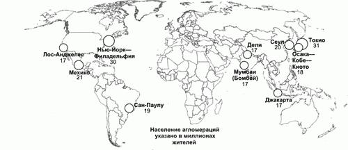
Thus, in modern conditions of globalization and urbanization big cities grow and turn into agglomerations, of which there are more and more in the world.