The Gulf of Finland located in the east Baltic Sea... Its area is 29.5 thousand square kilometers. It is the largest bay after the Bothnian bay, the area of which is 117.0 thousand square kilometers. From the north, south and east, the Gulf of Finland is bounded by the mainland land; it washes, respectively, Finland, Estonia and Russia. The imaginary line between Cape Pyyzaspea and the Hanko Peninsula is western border bay.
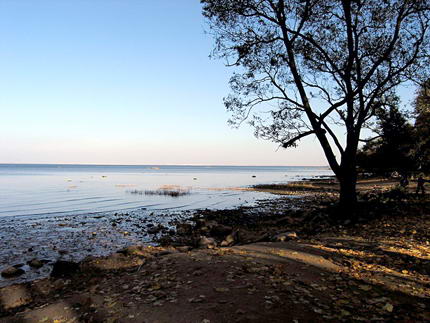
Its eastern shores are called. The Neva flows into its top with several branches. The Gulf of Finland in St. Petersburg (see the photo in the article) is one of the main water areas of the city. northern capital located in the most eastern part of it. Most of the main rivers that flow through the territory Leningrad region and St. Petersburg itself, flow into the bay.
Characteristic
The average width of the bay is 80 km. In some places it expands to 130 km (the region of the Narva River). The length is about 400 km. The Gulf of Finland in St. Petersburg is shallow, so the water warms up quickly enough. The average depth of the local waters (in the area of the Neva Bay) is only 6 m, while average depth The bay is 38 m, and the maximum is 121 m.
The water area of the Gulf of Finland abounds in small islets and skerries - small rocky archipelagos located near the coast. Also in the bay are artificial islands, which previously served to protect coastal cities from attacks from the sea.
The Gulf of Finland in St. Petersburg is practically fresh. The salinity of the local waters is reduced due to the flow of more than 20 rivers into the bay, the most significant of which are the Neva, Keila and Porvonjoki.
The shores of the bay, especially in the north, have an extremely indented relief, vaguely reminiscent of Southern border it is flooded and has a slightly less indented relief than the northern part of the bay.
Temperature regime
The average water temperature in the bay is 0 ° C in winter and about 15 ° C in summer. The climate is temperate. Summers are wet and short here, winters are long, cold and damp. This is the kind of weather that awaits tourists who want to visit St. Petersburg. The Gulf of Finland is covered with ice at the end of November and breaks up in the second decade of April. However, in warm winters, this water area may not freeze at all. In May-June in these places you can observe an amazing natural phenomenon - white nights. At this time, astronomically ("by the clock") night falls, but the illumination remains at the level of early twilight. Many people tend to visit St. Petersburg to observe this unique picture. White nights last for about fifty days. 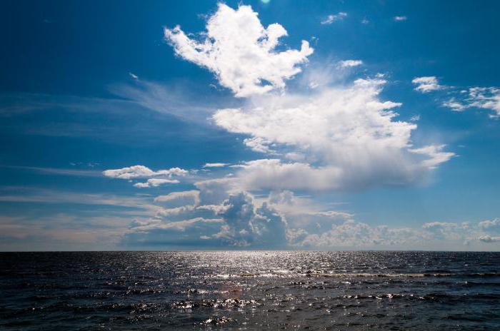
Geographic feature
The Gulf of Finland washes the shores of three countries: Russian Federation in the east, Finland in the north and Estonia in the south. On the coast are the capitals of two countries - Estonia (Tallinn) and Finland (Helsinki), as well as the second most populous city of the Russian Federation - St. Petersburg. It is the cultural center of Russia.
Shipping
The Gulf of Finland in St. Petersburg (photo below) is navigable, but in the area of the Neva Bay it is extremely shallow. For ships, there is a specially laid sea channel (fairway) with a length of almost 30 km, going from the mouth to 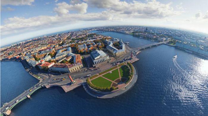
Vegetable world
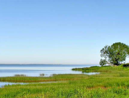
The coast of the Gulf of Finland and the surrounding area are considered to be part of the southern taiga. Pine, spruce and deciduous forests are widespread here. Due to the boggy shores, the Gulf of Finland in St. Petersburg is surrounded by wetland flora, which is represented mainly by lacustrine reeds and also many aquatic plants grow here, such as water lily, egg capsule, acute sedge and maritime valerian.
Animal world
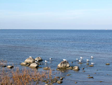
The fauna of this region is also impressive. Among the birds you can find several partridges, geese, hazel grouses, woodpeckers and thrush, cuckoos and tits. Small and large mammals can be found: from squirrels and beavers to wolves, wild boars and bears. The Gulf of Finland in St. Petersburg favors the development of fishing. The most important fishing grounds are located on the northern coast. The bay is home to marine and freshwater fish, including cod, sprat, pike, salmon, eel, whitefish, perch, pike perch, bream and some others. 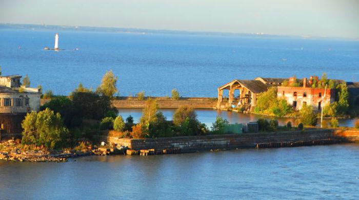
Gulf of Finland in St. Petersburg: rest
Due to the varied, colorful nature and the richest history, the area of the Gulf of Finland is very attractive in terms of tourism. In the spring, the bay could more than satisfy the needs of the most inveterate fisherman: the fish resource here is large and quite diverse. In summer, this water area offers its own coastline to lovers of sunburn and sea procedures. In the warm season, the water of the bay warms up well, but due to the unsatisfactory environmental situation, swimming here is paid, but you can go on a boat or boat ride. There is also something to satisfy cultural needs, because many people want to visit St. Petersburg, and those who have already visited these places come back here more than once.
The eastern part of the Baltic region stretches for 390 km and has a depth at the entrance of up to 100 m. The largest river Neva flows into the Gulf of Finland with a spillway of more than two thousand cubic meters per second, which has a significant impact on the entire Baltic region.
The Gulf of Finland is a shallow, closed and vulnerable sea area.
Nearby 20 million people live in Russia, Estonia and Finland.
The future of the Gulf of Finland depends on many drops - large and small
The southern coast of the Gulf of Finland is characterized by a combination of large anthropogenic objects - agricultural complexes, a nuclear power plant, a network of ports and unique natural and historical corners - the Lebyazhye ornithological reserve, Kurgalsky, Gostilitsky and Kotelsky reserves, natural monuments.
The coastal coast as a whole needs to be protected both as a unique element of the landscape and habitat of animals, and as a potential territory for organizing tourist zones and facilities - a resource for economic development with gentle nature management. To preserve the unique look of this territory, natural environment habitat of our and future generations, it is possible not only to achieve giving natural zones a protected status, but also, regardless of their status, to take them under the protection of public environmental organizations, to promote their natural value and control their condition.
The described territory is bounded from the West by the Narva River, from the East by the Strelka River, from the North by the waters of the Gulf of Finland, and from the South by the St. Petersburg - Tallinn highway. The nature of this region has a certain uniqueness. Its originality is determined primarily by the fact that it was covered with ice of the last glaciation (about 10 thousand years ago), and its landscapes bear clear signs of youth in the relief of surface deposits, hydrographic network, organic world.
Climate features, primarily the prevalence of northwestern winds from the Atlantic, also influenced the development of organic life. Another determining factor in the formation of the present appearance of the territory is a powerful anthropogenic impact, as a result of which today we see an anthropogenically modified landscape almost everywhere here.
Most of this territory is located within the Pre-Glint Plain, terraced as a result of the activity of the Litorin Sea (named after the mollusk that lived in shallow waters ancient sea 3-6 thousand years ago. The sea began to recede about 3,800 years ago, leaving coastal terraces in place of their former bottom). Western part of the described region is occupied by the North-East of the Narva lowland.
The lower Primorskaya terrace stretches in a narrow strip with 3-5 meters marks along the coast, up to 1 kilometer wide and is bounded from the south by a ledge with marks of 10-18 m. This is a lowland with individual heights and typical lacustrine-glacial landscapes. The coast of the bay is mostly sloping with sand dunes and coastal ramparts.
The soils here are formed on the basis of the bottom of the ancient sea. At the very coast there are fine sands, here you can see picturesque "white dunes" overgrown with pine trees (for example, between Goravaldayskoye Lake and Batareinaya Bay, on the territory of the town of Sosnovy Bor and to the west of it, in the south-west of the Kurgalsky Peninsula). A little further from the bay, the soils are mainly peaty and peaty-podzolic. There are many pine forests here different types- lingonberry, dry heather and grass.
The second terrace is 10-18 meters high. On its territory, from the first ledge to the south to the borders of the Ordovician Plateau, the underlying rock is mainly blue Cambrian clay 50-60 meters thick. The soils are sod-podzolic, low-fertile, less coniferous, more birch, aspen. From the south, the second terrace is bounded by the Baltic - Ladoga glint (from the Danish word glint - cliff, ledge)
To the south of the klint, the Ordovician plateau extends. Its western, elevated part is called the Izhora Upland (up to 168 m abs.) And borders the basin of the Gulf of Finland from the south. Its distinctive feature is the almost complete absence of rivers and lakes. On the Ordovician Plateau, the parent rocks are deposits of the Ordovician period, crushed stone limestones. Soils are soddy-calcareous with a high humus content, highly fertile.
There are few forests here. Spruce forests with an admixture of broad-leaved species are widespread, which have survived mainly on the slopes of the hills. A special relief has been formed within the Kurgalsky Peninsula, due to the Kurgolovsky plateau, ledges descending to the sea, which also served as the shores of the ancient Litorin Sea.
Water resources
The most large rivers in the southern part of the Gulf of Finland basin - Luga, Sista and Kovash. An important role in their nutrition is played by groundwater, which forms in the karst cavities of the Ordovician plateau. Many bog massifs give rise to numerous rivers and streams flowing into the Gulf of Finland in the Lomonosov and Kingisepp districts.
These rivers are shallow. The water level in them rises only during rains and in spring. The most significant rivers are Strelka, Shingarka, Karasta, Lebyazhya, Chernaya (B. Izhora), Voronka, Peypiya.
Excessive moisture, flat relief and close to the surface bedding contribute to the spread of bogs. groundwater... Eaters predominate atmospheric precipitation raised bogs of the oligotrophic type with a convex surface and significant peat deposits. Lowland swamps are found in small areas in the coastal strip of lakes. Their food is mainly due to flood waters.
Lakes are mostly glacial origin... They were formed during the melting of ice blocks left after the glacier, and are located in pre-glacial depressions - hollows and in hollows among moraine hills (Kopanskoe, Khabalovskoe, Babinskoe). Their shape is elongated or round. The depth is usually shallow - up to 4 meters, the bottom is muddy, but they can be more than 20 meters deep (Glubokoe). The shores are low, often swampy. Many lakes are overgrown with bottom and shores.
In addition to glacial lakes along the coast of the bay, there are floodplain and lagoon lakes. Lake Goravaldayskoye, for example, was separated from the bay by a strip of dunes several thousand years ago. Lakes Lipovskoe and Beloye arose as a result of siltation of the mouth sections of a river that once flowed to the sea.
There are considerable underground reserves of fresh water in the region. On the territory of Petrodvorets from the "Gdovsky" horizon is mined mineral water"Peterhof", which treats diseases of the liver, biliary tract and stomach. For the water supply of Petrodvorets, water from the springs on the Ropsha Heights is used. Near the village of Lopukhinka, underground radon springs feed the lake, the waters of which were used in the last century in a hydropathic establishment to treat sailors from joint diseases; other radon springs are also known on the slopes of the Ordovician plateau. Sodium chloride springs were found in the Ust-Luga volost. Hard artesian waters, extracted from the village of Gostilitsy, are used to supply water to Lomonosov and several villages. There is almost no fresh groundwater on the pre-glint lowland of the southern coast of the Gulf of Finland.
The originality of this region is determined by the unique natural zones that have survived in today's anthropogenically altered landscape. First of all, these are coastal areas, some of which have the status of "specially protected natural areas"(SPNA) - nature reserves Kurgalsky, Lebyazhy and Kotelsky. Two of them - Kurgalsky and Lebyazhiy - in addition, are wetlands of international importance, mainly as habitats for waterfowl,
The nature of the Gostilitsky Botanical Sanctuary is valuable with unique broad-leaved oak forests and herbs. The officially approved natural monuments in the described area are a radon lake in the village of Lopukhinka and an oak grove near the village of Velkota. In addition, the region has natural areas and objects that need protection and do not have a protected status.
Here are a few of them:
· Dunes "White Sands" at the Bay of Battery, in the town of Sosnovy Bor and to the West of it.
Dunes in the south-west of the Kurgalsky peninsula
Koporsky glint
Suryevskoe swamp
Lake Lubenskoe
· Oak grove in the village Martyshkino ("Mordvinovskie oaks")
· Oak grove in Kronkolonia ("Petrovskie oaks").
The first mention of the lifestyle of the inhabitants of these places dates back to the 5th century BC. This was done by the Arab historian Al-Marvozi. He wrote: " As for Ar-Rus, they live on an island in the sea. That island occupies a space of three days' journey in both directions. The island has forests and swamps, and it is surrounded by a lake. They, the Rus, are numerous and see the sword as a means of subsistence. If a person dies with them and leaves daughters and sons, then all the property remains for the daughters. Sons are given only a sword and they say: "Your father got good with the sword, follow his example ...
"".
There is reason to believe that here we are talking about the island Rus - the current Karelian Isthmus and its inhabitants - the Rus-Varangians, who later came to be called Korela. The Scandinavian name of these places is Gardarikia (Garda is the designation of Rus, riki is the state).
Votlandia - that is how the ancient Western authors called the land near the mouth of the Luga River, where the Vod people lived.
Another tribe that lived on the southern coast - Izhora called their land Inkerinmaa (maa - land in Finnish dialects). After the Peace of Orekhovets in 1323, Finns - Lutherans from the eastern provinces of Sweden - Savo and Eyurepää began to arrive here.
There is evidence of the nature of the attitude of local tribes to Nature, which retained echoes of paganism until the 16th century. Archbishop Macarius of Novgorod in 1534 notified the Grand Duke Ivan Vasilyevich:
"In Votskaya pyatina, in Chudi and in Izhera, and near Ivanyagorod and Yama grad and Karela Grad, and Koporia grad, and Ladoga grad, and Oreshka grad, and throughout the Pomorie of the Varangian [now Baltic] Sea in Novgorod land, and along all Pomor rivers from the German border and the Livonian, and from the Nerova River to the Neva River ... and beyond the Neva [Ladoga] Lake is great ... for a space more than 1000 versts in length, there are many idolatrous superstitions, and that in Chud and in Izher and korele and in many other Russian places there are also "nasty idols' prayers." The essence of the filthiness of the prayers of their forest and stones, and rivers, and blata, and springs, and mountains and hills, the sun and the moon and stars and ezera, and in general, these inhabitants worship every creature like God and offer a blood sacrifice to demons: oxen and sheep, and all livestock and poultry. It was heard that some secretly kill their children and set the images of the saints on fire
".
The great dukes, having learned this, commanded " beauty onu"to eradicate why Archbishop Macarius sent the monk Ilya to eradicate the idol's delight, who, destroying entreaties, chopped and burned forests, throwing stones into the water and baptized the unbaptized. After the defeat of Russia in the Livonian War (under Ivan the Terrible) and the signing of the Stolbovski Peace Treaty (1617) year), these lands were transferred to Sweden for 90 years.At this time, the Swedes added their "land" to the local Izhora name of these lands, and their new acquisition became known as Inkerinmaaland (the country of the Izhora land). At this time, tribes from eastern Sweden began to come here Another migration flow to these lands was from the southeast.
The Russian historian Klyuchevskoy wrote in 1904 about the migration of Finnish tribes driven northward from the banks of the Moskva River and the Oka: " Most of them belonged to the peaceful rural population. The settlement took place, not the conquest of the region, not the enslavement or displacement of the natives ..."An indication of such a peaceful course of the historical process of the settlement of these places is reflected in the toponymy of the southern coast of the Gulf of Finland. Russian and Finnish names settlements not grouped into certain places, but they go interspersed.
Let us compare the names of settlements when moving along the southern coast of the Gulf of Finland from east to west: Finnish Oyankyla (now the village of Ruchi) - Russian Ustye - Finnish Rakopezhi - Russian Dolgovo. The last village is now occupied by the Leningrad nuclear power plant. Thus, at the everyday, everyday level, there is no interethnic strife among local population and no "new translators" were observed. Apparently, a large role in this was played by the fact that entering the ancient Novgorod state, which is a member of the European Hansa, the local population did not experience any external pressure.
After the Northern War and the victories of Peter the Great, all of Russia was divided into eight provinces, and the southern coast became part of the Ingermanland province. Its first governor-general was His Serene Highness Prince A.D. Menshikov ...
The local population of this province, in addition to traditional activities - hunting, fishing, kept livestock, was engaged in various crafts. Excellent craftsmen worked in Vodskaya pyatina: stove-makers, carpenters, blacksmiths, saddlers, potters. In the last century, potters from the village of Ustye were very famous. Fine flax was also grown here.
In the middle of the 18th century on the river Ruditsa M.V. Lomonosov founded the Ust-Ruditsk factory of colored glass (smalts). Famous mosaic paintings were made from it. In the nineteenth century, a glass factory was built in the village of Kalische, which had no equal in Europe. He used the local sands, which are rich in these lands, as raw materials.
During the Soviet period, a significant part of the indigenous population of the southern coast was expelled or destroyed.
Today, of the five thousand Vodi people, 62 people remain, of the eighteen thousand Izhorian people - 820 people, of which 500 live in Russia. Of the nearly two hundred thousand population of Finns-Lutherans who lived in the Leningrad region, today there are 15 thousand left here. And 50 - 70 thousand live in the Far North, unable to return to their historical homeland. Over the past 100 years, fierce military battles have been fought on the southern coast of the Gulf of Finland, which devastated these lands. Many villages have disappeared ...
Thus, the ethnographic experience and culture of organizing the life of the local population, which had formed over many centuries, were largely lost. At the same time, in the last decades of the Soviet period, conditions were created new wave migrations from different regions the former USSR to the south coast. Tens of thousands of new residents have arrived here in a short historical period. The lifestyle of the new wave of settlers did not become an evolutionary continuation of the ethnographic experience of the indigenous population ...
The possible construction of new ports and the further development of nuclear energy on the southern coast of the Gulf of Finland will inevitably lead to a new wave of migration to an area where islets of wilderness that have formed over millennia are still preserved. In this case, they will inevitably be destroyed. Forever and ever. This will be the case if you and I - the current inhabitants of the southern coast of the Gulf of Finland, our children, cannot organize our life in any other way, we do not protect what is dear to us. The choice is ours ...
The swim from St. Petersburg to Kronstadt takes place in the water area of the Gulf of Finland of the Baltic Sea.
What do we know about the Gulf of Finland?
The bay is located in the Eastern part of the Baltic Sea, washing the shores of Russia, Estonia and Finland. On the shore of the bay at its most eastern end, at the confluence of the Neva River into the bay, there is St. Petersburg. Other major port cities of the Gulf of Finland are Kronshtadt and Vyborg in Russia, Tallinn in Estonia, Helsinki, Turku and Kotka in Finland. The large rivers Neva, Luga, Narva flow into the bay.
The eastern end of the Gulf of Finland, from the mouth of the Neva to the Kotlin Island, is called the Neva Bay. Actually in this part of the Gulf of Finland the swim takes place.
The area of the Gulf of Finland is 29.5 thousand square kilometers, and the length is 420 kilometers. The maximum width reaches 130 kilometers (in the Narva region). At the entrance (in the neck) it is 70 km, and in the Neva Bay - only 12-15 km. The Gulf of Finland is considered shallow, with depths decreasing to the east. In the mouth of the bay, the depth reaches more than 100 meters, in the middle part of the bay west of the island Kotlin - already 20-30 meters, and in the Neva Bay - only 2 - 6 meters. There are even shallower places in the coastal strip of the Neva Bay. The passage of ships to St. Petersburg is possible thanks to the Morskoy Canal, laid along the bottom of the Neva Bay.
In terms of salt content, the Baltic Sea is the most freshwater of all seas. This is due to the fact that about 40 rivers with fresh water flow into it. And, of course, the Neva River makes a big contribution to the desalination of the Baltic Sea and, accordingly, the Gulf of Finland (in the Gulf of Finland, the water is practically fresh). The length of the Neva River is only 74 km, but, despite this, it flows through the territory a little less than the territory of Italy. The Neva delta includes lakes: Ladoga, Onega, Saima, Ilmen, as well as rivers: Svir, Volkhov, Vuoksa. It is believed that there is only one such water system in the world - the Great Lakes in North America... The Neva carries more water than the Don and Dnieper combined.
A bit of history.
In the 9th century, the eastern shores of the Gulf of Finland were in the possession of the Novgorodians, who called this territory the Vodskaya pyatina. The name "Gulf of Finland" (in Finnish - Suomenlaht), known since the 30s of the XVIII century, was given by the name of the people who inhabited the territory on the northern shore of the gulf. In 1737-1793, the bay was also called Kronstadt.
Since about the 6th century, the Gulf of Finland has been a major sea trade route. In particular, the famous route "from the Varangians to the Greeks" passed along it (the Baltic was called the Varangian Sea in the old days). V VIII-X centuries thousands of tons of silver were delivered across the Gulf of Finland to Northern Europe. At the time of the Hansa, the trade of Russian lands with northern European cities was carried out through it, and in the 17th century, the entire economy of Sweden was held on trade through the Gulf of Finland. After Russia gained access to the Baltic Sea, the Gulf became the main channel of international trade for Russian Empire.
As a result of the Northern War of 1700-1721 Eastern The Gulf of Finland became part of the Russian Empire. The active construction of defensive structures began in the water area of the bay. Forts and batteries are being built, which served as the basis for the formation in 1705 on the Kotlin island of the city of Kronstadt. The annals of history store a lot of information about the rich military past and numerous military battles in the waters of the Gulf of Finland by the fleets of various states.
The Neva Bay, in fact that part of the Gulf of Finland, in which our swim takes place, has received the ironic name of the Marquis puddle among the people. It arose among the sailors of the Russian navy in the first third of the 19th century. In 1811-1828, the Marquis de Traversay was the naval minister of Russia, under whom the long-distance campaigns of the military squadron almost stopped, and the ships, as a rule, did not go beyond Kronstadt. The expression "Marquis puddle" is still used today, especially to emphasize the shallowness and small size of the Neva Bay.
During the siege of Leningrad during the Great Patriotic War, sailors called the Gulf of Finland stuffed with mines "soup with dumplings." And modern "sea wolves" joke that when the lighthouses are lit, the bay is "lit like Nevsky Prospect."
Currently, the bay has a large strategic importance for Russia, as well as for the defense of the state's borders, and for the development of economic activities, tourism and sports.
In the water area of the Gulf of Finland, sports competitions are held not only in summer (sailing, windsurfing, sport fishing), but also in winter (winter kiting and windsurfing, snow kiting, ice fishing).
The Gulf of Finland is located in the eastern part of the Baltic Sea. Its waters wash the shores three countries- Russia, Estonia and Finland. The northern capital of Russia - St. Petersburg, the capital of Estonia - Tallinn and the capital of Finland - Helsinki, and 18 other cities of these Baltic countries are located on the shores of the bay.Gulf of Finland on the map
The salinity of the Gulf of Finland is insignificant (from 0.2 to 9%), this is due to the confluence of more than 20 rivers and canals, among which the largest are the Neva, Keila, and Porvonjoki. In the Gulf of Finland, there are the islands of Kotlin, Vysotsky, Powerful, Lisiy, a group of Birch Islands and 12 more smaller ones. In addition to these, 19 more artificial defensive forts-islands were built in the bay. Their construction began at the beginning of the 18th century, during the Northern War. The Gulf of Finland is difficult to navigate, there are many banks, shoals, islands. The area of the Gulf of Finland is 29,500 sq. km, length 420 m, smallest width - 12 km in the Neva Bay, here is also the smallest section of the bay - 6 m (in the coastal zone about 1 m). The widest part of the Gulf of Finland is located on the meridian of Powerful Island - 130 km, in the throat the bay is about 70 km wide. The Gulf of Finland is considered shallow. Its maximum depth is 121 m, average - 38 m. The Neva Bay is deepened by a sea channel.
The bay was formed during the Valdai glaciation more than 12 thousand years ago. Its northern shores are rocky, winding, abound in fjords and skerries, large bays and peninsulas. The southern ones are flooded and swampy, gently sloping. A 40-meter-high klint stretches along the southern coast, formerly the coast of the Littorin Sea, and the islands were exposed when glacial reservoirs were shallow about 4 thousand years ago, when their level dropped to the current level of the modern Baltic Sea.
From November to April, the Gulf of Finland is covered with ice, but in warm winters the waters of the bay do not freeze. There are beaches on its shores, but in summer many of them are closed to tourists due to the poor ecological state. With strong westerly winds, a surge occurs in the bay, often leading to floods in St. Petersburg.
The region of the Gulf of Finland is located in the southern taiga belt, which is characterized by forests, meadows and swamps. The forests are dominated by spruce and pine trees, deciduous forests are birches, gray and black alder, mountain ash, willow and aspen. The swampy areas are overgrown with reeds, reeds, cattails, water plants - egg capsules, white water lilies, naiads, ruppias, water colors, and stuccoes.
On the southern coast of the Gulf of Finland there is the Lebyazhy bird sanctuary and 3 sanctuaries - Kurgalsky, Kotelsky and Gostilitsky - these are specially protected areas.
The fauna of the Gulf of Finland is diverse; the ringed seal and the gray seal (listed in the Red Book) live here. Ichthyofauna is represented by marine and freshwater fish species: Atlantic salmon, whitefish, eel, goby (3 species), loach, tench, silver bream, smelt, crucian carp, catfish, perch, vendace, garfish, flounder, lamprey, sprat, ide, sneeze. It is also home to endemic species: Baltic herring and cod.
Active economic activity led to deplorable ecological state waters of the Gulf of Finland and its coasts. Marine life and terrestrial flora are endangered.
The area of the Gulf of Finland was inhabited as early as 3.5 thousand years ago.
The city of Kronstadt, located on the island of Kotlin - the city of Russian sea glory, is famous for its historic buildings and defensive forts.
The Gulf of Finland wore in different times such names: Vodskaya pyatina (among the ancient Novgorodians), Kronstadt, Moscow, and a site in the area of about. At the beginning of the 19th century, sailors called Kotlin the Marquis puddle, this immortalized the memory of the not-far titled naval minister Traverse I.I.
Since the Great Patriotic War, the sea has been cleared by a quarter, the rest of the unexploded mines pose a great danger to underwater work. At the bottom of the Gulf of Finland with Russian side more than 5,000 sunken ships, airplanes, Vehicle... Cold water and low salinity contribute to the preservation of most objects. Used photographs from Wikimedia © Foto, Wikimedia Commons
- the eastern part of the Baltic Sea, jutting deep into the mainland. In the north, the Gulf of Finland is washed by the northwestern ones. From the west, the maritime boundary of the bay is considered to be the line connecting Cape Gangaudd on the coast of Finland and the Daguerort lighthouse on Dago. The length of the bay from the Neva Bay to the Daguerort meridian is 444,480 kilometers, the maximum width of the bay is 120,380 kilometers on the meridian of Narva Bay, to the west of Narva Bay the bay gradually narrows, and before entering its width it decreases to 74,080 kilometers.
Shores. The southern coast from the Neva Bay is directed to the west by low and sandy hillocks, turning into hills, now steeply descending to the sea, now moving away from it. Having reached the so-called Shepeleva, the coast turns to the south and forms the Kaper Bay, named after the region and the ancient castle, the ruins of which are located near the Sista, which flows into the named bay. Beyond the Kaper Bay, ending in Cape Kolganpya, the coast forms a new lip, Lugskaya, named after the Luga River, which flows into it. By east coast the lip stretches the ridge of the rather high Soykina mountain, consisting of two hills. Beyond the Lugskaya Bay, the bank forms the wooded Kurgalsky Peninsula, and then the Narva Bay, which receives the Narova River. The coast of Narva Bay is low-lying, sandy and covered, slightly further from the coast there are gentle hills.
Heading west from Narva Bay, the coast first becomes steeper, with a large number of cliffs, and then becomes low again and forms a number of bays, of which the most significant are: Kunda, Kashpervik, Monvik, Paponvik, Kolkovik, Revelskaya Bay, Rogervik. Before the beginning of Rogervik Bay, the coast forms Cape Pakerort, which is distinguished by its inaccessible precipice of considerable height. When the bay enters the sea, the final boundaries are the islands of Worms and Dago.
The northern coast of the Gulf of Finland, starting from Cape Dubovsky, goes to the west, gradually rising, and descends to the sea as a terrace. Behind Cape Stirsudden, the coast goes north-north-west to Bierke-Sound, leaving a low-lying edge near the water with a width of several meters to half a kilometer or more. In some places, the coast here represents not one, but two or even three terraces, which from the sea, thanks to the forest, seem to be one continuous high bank... The forest here is mostly medium-sized, pine, while at Bierke it is birch. Often the coastal strip, up to several kilometers wide, is devoid of continuous forest and is covered with bushes.
Soon beyond Cape Steersudden, the so-called skerries begin, consisting of numerous large and small islands, usually quite high and covered pine forest, partly having the appearance of bare rocks of reddish. Underwater and surface stones are scattered between the individual islands. Passage in the skerries is possible for ships only accompanied by experienced pilots.
Islands in the Gulf of Finland so many. Of the more significant islands, besides skerry, we mention Kotlin with the city of Kronstadt, Seskar, Lavensari, Sommers, Nargen, Gogland, Odensholm. In addition, there are many cans and shallows scattered throughout the space.
From the mouths of the Neva River to Kotlin Island, the depth gradually increases from 2.4 to 6 meters, and in some places to 6.3 and 6.6 meters. Behind Kotlin Island to the west along the fairway, the depth increases to 40 meters, while at the southern coast, in the Kaporskaya and Luga bays, the depth is from 10 to 22 meters. Near the island of Sescara, the depth in the middle of the bay is uneven, sometimes between 39.6 meters there are elevations with a depth of 21.6 - 27 meters, and between 16.2 and 18 meters there are holes up to 36 and even up to 52.2 meters. From Seskar to Gogland, the depth increases to 63 - 72 meters. From Gogland to the west, the depth is at first very inconsistent. Between the depths of 66.6 - 48.6 meters, spots of 28, 25 and 21.5 meters come across, further to Cape Surop the depth is somewhat smoother and increases to 72 - 90 meters. From Surop to Odensholm Island, depths are from 48.5 to 108 meters, and deep places come pretty close to south coast, three and a half kilometers from which there are depths of up to 54 meters. From the island of Odensholm to reaching the depths, they gradually increase to 126 meters.
The Gulf of Finland is silty and sandy and very often stony, while silt is more common at great depths, and sand and stone at shallow depths. Flow in the Gulf of Finland is associated with winds, and surface currents sometimes reach speeds of 0.5 to 1.5 nautical miles per hour and even more. After strong south-westerly winds, there is a noticeable current from the skerries to the north-west, reaching up to 3 nautical miles per hour. With prolonged calm in the bay, there is a weak current in the west; this current depends on the excess of fresh water profit over its loss from evaporation. The flow to the west is most noticeable in the eastern part of the bay, with two branches separating on the meridian of Cape Stirsudden, one of which goes northwest to Bierke-Sound, and the other southwest to Kaporskaya Bay. The current is also felt in the western part of the bay, especially south of Odensholm, where it gradually turns into Moon Sound. With fresh westerly winds, the current is directed to the east. When leaving the Gulf of Finland into the Baltic Sea, a southerly current coming from the Gulf of Bothnia is noticeable. After fresh south-west and north-east winds, temporary currents in the Gulf of Finland are seen off the islands of Somersa and Lavensari. In the northeast to the Vyborg Bay and to the south to the Narva Bay.
Gulf of Finland (photo by Ekaterina Smirnova)
Level changes. From 26 years of observations in Kronstadt, it was possible to notice the correct changes in the level, which have the character of - ebb, the amplitude of which, however, does not reach five centimeters. When calm, the water level, according to observations in Kronstadt, is usually below average by 8 - 9 centimeters, which depends on the prevalence of westerly winds in general in the bay over easterly, as a result of which average level is higher than the level at calm. In the annual course of fluctuations in the level of the gulf, some correctness is observed, as in the whole basin of the Baltic Sea in general. In Kronstadt, for example, long-term observations show that from August to January the average level is above normal; March, April and May the level is below normal, the rest of the time it is close to ordinary.
. The prevailing direction of winds in the western part of the Gulf of Finland in autumn and winter is south, south-west in spring, and west in summer. In the eastern part, in autumn and winter, it is south-western, in spring, south-western and western, and in summer, western. The greatest wind strength is achieved mainly in autumn and winter. The greatest number of storms in the Gulf of Finland occurs in October, mainly from the southwest. Total fogs in the Gulf of Finland more in winter(maximum in January) and total less in summer(minimum in July).
Navigation on the Gulf of Finland is very convenient, as it is well furnished with lighthouses, towers and warning signs, the total number of which reaches 300.


