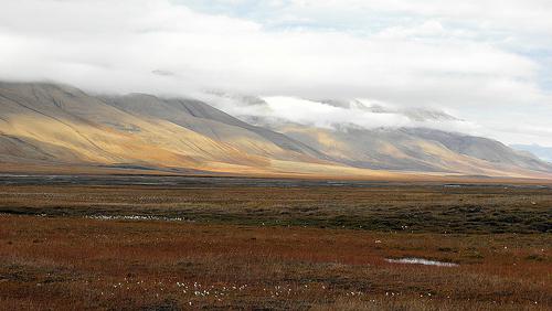
The tundra covers northern Russia and Canada. Its nature is rather scarce, and the climate is considered to be harsh. Because of these characteristics, it received another name - arctic desert... If we consider the geographical position of the tundra, we can see that this zone includes the islands located in the Arctic Ocean, and the northern part of Russia and Canada.
Location of the tundra zone
The Arctic desert stretches in a wide strip along the entire coast of the Arctic Ocean. Here the climate is not mild and high temperatures, and nature is scarce and undersized. In the tundra, winter lasts nine months, while summer is rather cool.
Low temperatures lead to the fact that the ground freezes and does not thaw completely, but only the top layer can melt. In such a natural area, one cannot find forests and tall trees. This area is rich in swamps, streams, mosses, lichens, low plants and shrubs that can survive in such a harsh climate. Their flexible stems and low height adapt perfectly to the bitter cold winds.
Glaciers or stone deposits can be seen in vast areas. The tundra has an invaluable array of shallow small lakes. This can be especially seen on the map of Canada, Russia, Finland. The geographical position of the tundra contributes to the abundant high flow of rivers.
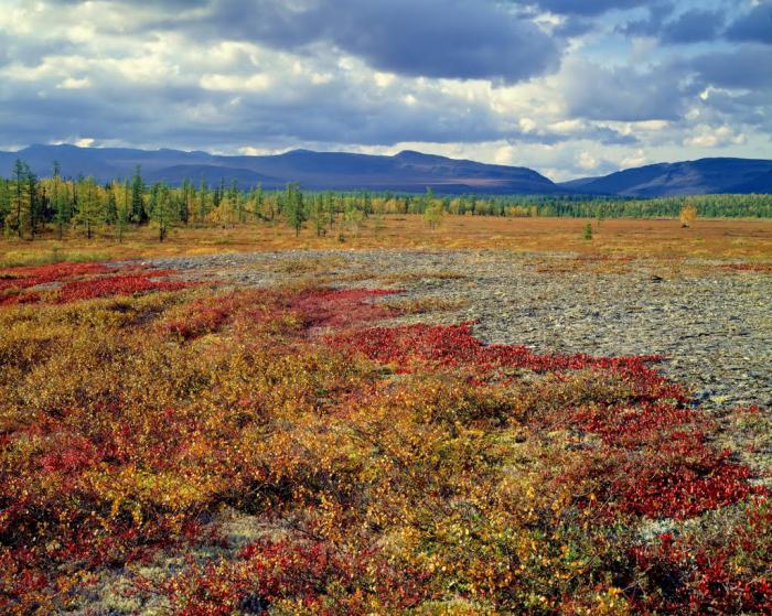
Inhomogeneous features can be noted geographic location tundra. From the north to the very south, there are three subzones. Near the Arctic Ocean there is an arctic subzone, then it is replaced by a moss-lichen one, to the south stretches an area consisting of dwarf birches, cloudberry bushes and the Tundra itself is very beautiful. In the summer you can see how it sparkles with bright colors. All thanks to the bushes of blueberries, blueberries, lingonberries, cranberries.
Climate in arctic deserts
The latitudes of the tundra zone have low indicators of the annual radiation balance. Winter in this zone lasts a long time - eight, or even all nine months. Unusually beautiful polar nights are observed here. In the cold season, frosts and winds are common. Winter air temperature in January for the European part of the tundra is up to -10 degrees below zero. However, closer to the east, the climate becomes sharply continental. Therefore, the temperature in January can reach -50 degrees and below degrees Celsius.
Summer does not last long, it is cold and windy, there is a long one. Usually the air in July is no more than 4 degrees Celsius, it is often possible to observe drizzling rain and fog. The geographical position of the tundra in Russia is a zone from the western part of the country up to It occupies 1/6 of the entire territory of the country. Siberia has the greatest length from north to south.
Heavy snowstorms and hurricane winds are common in this area. They are so impetuous that they are able to knock down not only a person, but also a deer.
What is the tundra in summer
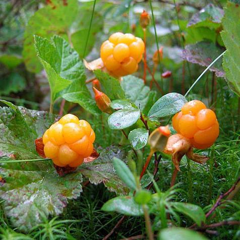
What are the features of the geographical position of the tundra in the summer? At this time of the year, you can spot edible mushrooms and a variety of delicious berries that stretch out in a colorful carpet, and you can also spot the herds of proud reindeer grazing. Thus, they look for their own food in the summer. Deer feed on everything they see: lichens, leaves of shrubs. In winter, they too will find food in the form
Unique flora
The organic world of the tundra is poor. The tundra-gley soils of this zone can hardly be called fertile, since they are completely frozen. Not all plants can survive in the harsh northern conditions, where there is so little warmth and sunlight. The best habitats here are lichens and mosses, polar poppy, black crow, princess, loidia late, swordweed sedge, saxifrage, snow buttercup and others. Such plants are an extraordinary delicacy for local wildlife. What other greens can you see in this area? About 300 species of flowering plants and almost 800 different species of lichens and mosses.
All plants are dwarf here. The so-called "forest" can reach you only up to the knee, and the "trees" will not be taller than the mushroom. The geographical position of the tundra is completely unsuitable for forests, and all because of the constant permafrost, which persists for many years in a row.
Animals of the tundra zone

On the steep rocky shores you can observe the noisy birds. The geographical position of the natural tundra zone is suitable for those animals that prefer the sea. A large amount of water is an excellent habitat for waterfowl: geese, ducks, loons. You can find passerines, waders, waterfowl, white geese, peregrine falcon, tundra partridge, lark. Here you will not find reptiles, but among the representatives of amphibians you can find frogs. Yet animal world rich in white hares, polar fox, weasels, foxes, wolves, polar and brown bears, musk oxen and, of course, reindeer. The tundra lakes are rich in a wide variety of fish - salmon, dallia.
Reindeer are another feature of arctic deserts
They are not only a feature, but also a symbol that the tundra zone is proud of. The geographical location for these animals is very convenient to inhabit. They exist not only in open windswept areas, but also on the islands of the Arctic Ocean. Moreover, these are the only ones from the family of ungulates that can exist here. We can observe large horns in both males and females. The main source of food for reindeer is tundra plants. These are lichens (lichen), buds, grass, small shoots of shrubs. In winter, they can extract plants from under the snow, while breaking it with their hooves.
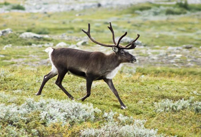
The coat of deer in winter is thick and long, the undercoat is well developed (to keep warm in severe frosts). In the summer, it becomes more rare and lighter. The summer color of deer is from grayish to brown. In winter, it is mostly white. The special structure of the hooves allows the reindeer to move successfully and quickly through swampy swamps and deep snow. These are gregarious and polygamous animals.
In winter, they move to places where extensive reindeer reindeer pastures are observed. One hundred or more kilometers from the habitat in the summer is not a problem for the winter migrations of deer. They shed no more than once a year. This animal is sensitive, has a great sense of smell, and also knows how to swim. Deer can freely swim across lakes and rivers.
How the components of nature in the tundra zone are interconnected
If we consider the geographical position of the tundra, it can be noted that forests begin in the southern part. This is how the forest-tundra originates. It stretches along the entire southern border of the tundra. It is already a little warmer here - in summer the temperature reaches 14 degrees Celsius. In the forest-tundra, a large amount of precipitation falls, which does not have time to evaporate. Thus, wetlands appear. The main food for the deep local rivers is melted snow. The first months of summer are the peak of high water. The geographical position of the tundra zone is gradually giving way to forest tundra.
Man began to explore the northern area long ago. Gradually, the landscape that stretches over more and more populated and transformed. Sea fishing is the main occupation of the northern peoples: the Chukchi and Eskimos. Hunting for local animals has established its own traditions of food and style of clothing. Meat of marine life, venison, fish, poultry are the main food products. Thanks to reindeer husbandry and hunting, the skins of fur and other animals are obtained, which are subsequently used as clothing.
How forest tundra differs from tundra
Forest tundra is located in the zone between the tundra and taiga. More forest with tall trees can already be seen in the river valleys. This is how the geographical position of the tundra and forest-tundra differs. Here, between the rivers, you can find small islands of low trees covered with lichen. Summer is warmer and longer here. Due to the presence of trees, the wind speed is not felt as strongly here as in the tundra, where the area is completely open.
Removing the forest-tundra from the ocean favors harsh winters with bitter frosts. Soils thaw much deeper, and permanent permafrost is observed only in some areas. The main food of the rivers is also melted snow.
The tundra is a natural area that lies north of the zone forests. On the territory of Russia, it stretches from the Kola Peninsula to Chukotka.
Climate
The tundra is divided into three types:
- South - closest to the forest zone.
- The middle one is north of the southern one.
- Arctic is the coldest, northern part of this natural belt... It borders on the zone of eternal snow.
Winter in this climatic zone lasts 8-9 months. Summer is short - 3-4 months. The frozen ground almost does not thaw in summer, so the tundra surface is called “permafrost”. Even in the middle of summer, frost and snow can fall here.
Summer temperatures never exceed + 10˚ C. The earth thaws only a few centimeters. In the southern part, it can be up to + 11˚C in summer. The land thaws there deeper and therefore many swamps and lakes are formed.
In winter, the snow cover does not exceed 15-30 cm. very strong winds ... Therefore, the snow does not lie, but is constantly moving. From any heights it blows away completely.
There is little precipitation, but there is still more of it than water evaporates from the ground. That's why the soil is saturated with moisture.
The soil
In the tundra there is sandy, clayey, peaty, stony soil. In the west of Russia, these are clay-sandy plains with many rivers, swamps and lakes. In the east there are mountain ranges and rocks.
Tundra soils are completely infertile. In high places where the snow is blown away by the wind, the soil has no vegetation at all. Only frozen clay or sand protrudes to the surface. Such areas are called "clay medallions".
Vegetable world
When the wind blows snow across the plain with force, it cuts off the protruding tops of grasses and bushes, as if cutting them. That's why plants cannot grow tall. Only in the lowlands of the southern tundra are there trees and shrubs as tall as a man.
Mostly they grow here grasses, mosses and lichens. The further north, the less grasses and more mosses are found. In the middle zone, we come across creeping willow and. In the Arctic, there are creeping shrubs.
On clay soils, mosses and grasses grow, on stony and sandy soils. Peat soils are dominated by mosses, berries and creeping trees. To all the plants in the tundra not enough warmth. Therefore, the roots of plants do not grow in depth, but along the surface.
Animal world
Aviation and all-terrain vehicles are used for communication in the tundra. All-terrain vehicles severely damage fragile vegetation, which then regenerates for decades. Most best transport the northern inhabitants are reindeer teams.
Although the tundra is poorer than other natural areas, it is able to feed polar animals and migratory birds. Therefore, you need to protect its nature.
If this message is useful to you, it's good to see you.
The tundra zone occupies a vast territory in the Far North of the USSR. In the European part of the USSR, it covers the northern half of the Kola Peninsula and further to the east the entire coast of the Arctic Ocean slightly north of the Arctic Circle. In Siberia, the southern border of the tundra zone runs along the Arctic Circle to the Yenisei River, where it rises to the north and stretches east along the 70th parallel to the Kolyma River; Further, it descends to the southeast, approximately to the base of the Kamchatka Peninsula.
The tundra zone also covers the islands of Vaigach, Kolguev, New earth, Severnaya Zemlya, etc.
The southern border of the tundra almost completely coincides with the southern border of the cold belt, that is, it goes almost exactly along the July air isotherm of + 10 °.
The area occupied by the tundra is about 3 million. sq. km, or 15% of the entire territory of the USSR.
Much attention is paid to the study of the tundra zone in our country. Many of our scientists took part in the studies of this vast zone: G. I. Tanfilyev, B. N. Gorodkov, Yu. A. Liverovsky, M. I. Sumgin, E. I. Tsyplenkin, V. N. Sukachev, L. S. Berg , A. A. Grigoriev and others. Nevertheless, the nature of the tundra zone, in particular its soil cover, is still insufficiently studied. What has already been done in this direction is only the first step in the knowledge of this huge, unique and, in its own way, very rich and promising land.
Climate. The climatic conditions of the tundra are characterized by low average annual temperatures, long cold winters, short summers and low precipitation, which is clearly seen from the data given in table. eighteen.
According to climatic features, the tundra zone can be divided into 5 regions: the western - with a soft maritime climate, Eastern European - with a transitional climate from maritime to continental; West Siberian - with a continental climate; East Siberian - with a sharply continental climate; the Far East - with a cold maritime climate.
Western part the tundra (north of the European part of the USSR) has the mildest climate. Average annual temperatures are negative here, but slightly below zero. January temperatures are about -10 °, and July temperatures are about + 11 °. The amount of precipitation is about 400 mm or more with a clear predominance of winter precipitation over summer.
As we move to the east, the severity of the tundra climate sharply increases. So, already in the east of the European part of the USSR, annual temperatures drop to -4-5 ° at a January temperature of -18-19 °.
Even more dramatic changes occur when moving to the Siberian tundra, where the average annual temperatures reach -15-17 °, and in the extreme east rise to -9 °. In the Chukotka tundra, January temperatures range from -30 to -40 °. In the extreme east, they rise to -25 °. July temperatures are in the range of 11-13 °, that is, higher than in the west.
Very low winter temperatures in the tundra zone of Eastern Siberia are caused by the influence of the Asian pressure maximum, which causes clear weather, weak winds and strong cooling of the air over the snow cover. The supply of extremely cold continental air of temperate latitudes is also observed here.
In the Siberian tundra, the annual precipitation decreases sharply, which rarely reaches 250 mm, and at many points it drops to 150-120 mm.
Thus, to the east, as in other zones, the continentality of the climate grows, which softens somewhat in the extreme east.
In winter, strong dry winds often blow, from which all vegetation protruding from under the snow freezes. The snow period is very long (up to 280 days), but the thickness of the snow cover is not great. Most of all precipitation falls in July - August and September, least of all - in February - March.
Moisture evaporation in this zone is very insignificant and on average does not exceed 50 mm in year. Predominance atmospheric precipitation above evaporation creates conditions for high soil moisture, as a result of which water is constantly retained on the tundra surface and soil development occurs with an excess of moisture. The low thickness of the snow cover makes possible deep freezing of the soil.
In the western part of the tundra zone, influenced by the warm current of the Gulf Stream, in summer time the soil is thawing, but most of the tundra zone is bound by permafrost.
Permafrost in the tundra zone is a very important factor.
Under the permafrost, as defined by prof. M.S. Sumgin, they understand such a layer of soil or soil located at a certain depth from the surface of the earth, which has a negative temperature, lasting continuously for at least 2 years, maximum - millennia and tens of millennia.
The geographic distribution of permafrost within our country is very large, especially in the Asian part of the USSR, east of Krasnoyarsk. Here, the southern boundary of the continuous permafrost distribution runs south of Irkutsk, Chita, Khabarovsk and the mouth of the Amur.
The layer of permafrost has different thickness, but in many cases its thickness is very significant. So, for example, off the coast Kara Sea, in Amderma, at the northern tip of Pai-Khoi, the permafrost strata was drilled to a depth of 400 m, in Transbaikalia near the Bushuley station, the permafrost has a capacity of 66-70 m, on Far East - 50 m etc. To the south, the thickness of the permafrost layer gradually decreases, reaching 1-2 m.
Above the permafrost layer there is an insignificant layer of earth that freezes in winter and thaws in summer. It is called the active layer. The depth of summer thawing usually ranges from 30-150 cm depending on the geographic latitude, as well as on the mechanical composition of the soil and the thickness of the peat. In sandy soils, thawing penetrates to a depth of 100-150 cm, in loamy - up to 70-100 cm, in peaty up to 30-40 see in In this limited layer, biological processes take place and soils develop.
Permafrost has a tremendous effect on the active layer overlying it: it cools the soil, does not allow water to penetrate deeper, and thus contributes to the stagnation of water on the soil surface. The presence of permafrost with low precipitation in summer often causes a peculiar phenomenon of physiological dryness, which plays a very important role in the life of Arctic plants.
Moisture in the permafrost layer is inaccessible to plants; if the ice melts, then the formed melt water, having a low temperature, is not very suitable for plants.
In the tundra, there is no sharp line dividing spring and summer, and the transition of spring to summer and from summer to autumn can only be discussed conditionally. The beginning of summer is usually taken as the disappearance of snow in most of the tundra, and the end of it is the first frost and snowfall at the end of August.
Summer in the tundra is short and cold, but with long daylight hours; frosts also occur in summer. The sun in the tundra is shown little, the cloudiness is very high and on average about 3/4 of the sky is constantly covered with clouds. The relative air humidity in winter is very low, while in summer it is very high, and in August it often reaches 80-90%.
The growing season is on average 2-2.5 months, but with the onset of warmth, due to the long daylight hours, the plants develop rapidly and bloom quickly.
Vegetation. Due to the harsh climatic conditions vegetation in the tundra is poorly developed and consists only of unpretentious northern plants that have adapted to the low temperatures of a short growing season. An essential feature of the tundra, which gives reason to call it the Arctic steppe, is its treelessness.
The word "tundra" (tunduri), taken from the Finnish language, denotes treeless places.
Many reasons hinder the development of forest in the tundra, but the main ones are low soil temperature and the presence of permafrost, which thaws during a short summer only to an insignificant depth, strong winds, high relative humidity and significant wetlands. Under these conditions, tree seeds germinate poorly, and their seedlings do not survive.
The flora of the tundra zone is generally very monotonous and poor in comparison with other natural zones and barely contains 250-500 different plant species.
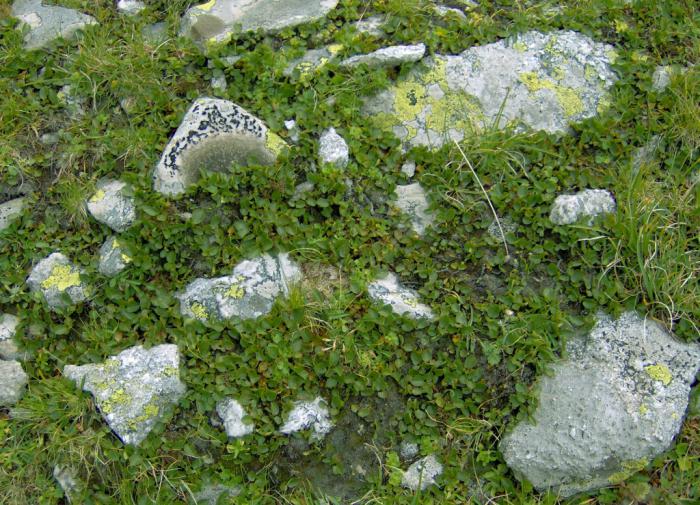
Mosses, lichens, some sedges and grasses are widespread in the tundra, which here, however, do not form a continuous vegetation cover, but grow in separate bushes and tufts.
Among the plants, prevailing shrubs of the cowberry type, shrubs of the heather type, blueberries, blueberries, etc. All tundra plants exhibit numerous signs of xeromorphism, that is, adaptability to arid living conditions.
A characteristic feature inherent in the vegetation of the tundra is the tendency of plants to grow in pillows, or tufts, which gives them better protection from the wind, and therefore from blowing, so destructive in the tundra. Coherent sod is found only in lowlands, which are covered with snow in winter and abundantly moistened in summer.
It should also be noted that lichens play an important role in the tundra, especially lichen, or reindeer moss, which is the main food for reindeer.
Parent rocks. The parent rocks in the tundra zone are mainly glacial deposits, then sediments of the boreal marine transgression and, to a large extent, eluvial formations of various crystalline rocks.
In terms of texture, they are quite diverse: sometimes they are plastic gray clays, sometimes more sandy clays and loams, and sometimes sands. Very often they are layered and contain the remains of marine fauna, and often boulders.
Among these sediments, there are places and outcrops of various bedrocks, including crystalline ones.
In Eastern Siberia, the tundra is located on stony rocks and products of their weathering.
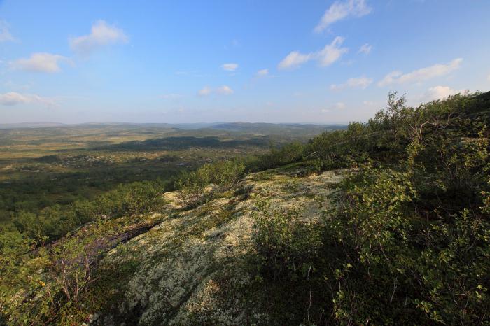
Relief. Large areas of the tundra zone are represented mainly by plains and low hillocks. The flat relief of the tundra is very often diversified by the presence of closed depressions occupied by lakes, by the presence of river valleys and spurs of mountain ranges crossing this vast zone in many places. In the mountainous regions of Siberia, the stony mountain tundra is widespread.
By natural conditions the tundra zone is not uniform and can be subdivided into the following subzones: arctic, shrub, southern tundra and forest-tundra.
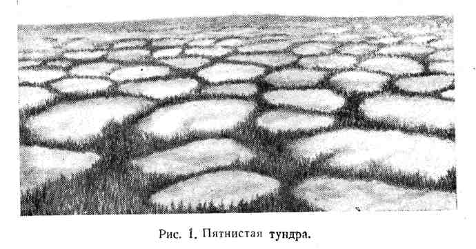
The Arctic tundra is located on the northern edge of the country, where there are no trees or bushes; the latter, if they do appear, it is only along the course of rivers. Spotted tundra is very widespread here. The spotted tundra consists of bare clayey patches the size of a plate or wheel, usually completely devoid of vegetation. The spots are interspersed into dry tundra covered with vegetation, or are only bordered by a border of mosses, lichens, small sedges, etc.
The origin of these spots has not yet been precisely determined. According to most researchers, spots in the tundra are formed in the following way. The exposed clay surface, upon freezing and drying, cracks and disintegrates into irregular polygons or rounded areas; the edges of the cracks then crumble, and vegetation settles in the formed gullies, but the surface of the patch remains bare, since due to strong winds the vegetation cannot take root; in spring, bare spots quickly thaw and blur. In the section of the spots, there are no buried vegetation layers and a humus horizon. At the same time, traces of gleying are clearly visible in the soil profile. There are no sphagnum peat bogs in this subzone.
Shrub, or typical, tundra goes south of the Arctic and occupies vast areas; there are no trees here either, and shrub thickets are found not only along rivers, but also in interfluvial spaces. The vegetation characteristic of this part of the tundra is divided into 3 tiers: the upper one is shrubby, the middle one is herbaceous, and the lower one is lichen-moss.
The first tier is dominated by birch dwarf birch, wild rosemary, shrub willow, blueberry, etc. In the middle, herbaceous tier, sedge, crowberry, fescue, lingonberry, etc. are widely developed. In the lower, directly covering the soil, brown and green mosses and lichens dominate ... Here, sphagnum peat bogs are often found, usually in the form of mounds 1-3 m high, which are very characteristic of the so-called hilly tundra. These peat mounds are mainly composed of mosses and lichens.
The surface of the hillocks is usually covered with creeping woody plants: wild rosemary, crowberry, blueberry, lingonberry, whitewash, marsh heather, dwarf birch and dwarf polar willow. Significant areas are occupied by lichen (reindeer) and lichen-moss associations.
In the river valleys, the same bushes grow as on the watersheds, but here they reach a greater height, sometimes 1 -1.5 m. On the banks of rivers and lakes, thickets of sedges are often found, and willow stands in river valleys; dwarf birch is found everywhere in abundance.
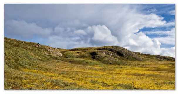
Southern tundra located south of the shrub. A characteristic feature of this subzone is the presence of forest vegetation located only along the course of rivers. On the watersheds, among the shrub thickets, occasionally there are individual trees (spruce, birch and larch). Sphagnum mosses are widely developed, forming small peat bogs.
The forest-tundra is a transitional strip from the tundra zone to the forest zone. It is located on the southern edge of the tundra, on the border with an area of continuous forests. In this subzone, forests grow not only along rivers, but also in small islands in the interfluve, in watersheds.
Polar birch species usually settle here first. and larch, always covered with lichens and strongly oppressed. The harsh conditions of the tundra, the poor soil nutrients, and the presence of permafrost in most of the tundra at a shallow depth make the growth and development of woody plants very difficult. Trees 200-300 years old, stunted, clumsy, knotty, have a diameter of about 5-8 cm.
The forests here are usually confined to small, but very numerous sandy and clayey mounds, the depressions between which are occupied by swampy spaces or dense bushes of small willow, dwarf birch, and where the terrain is higher, also juniper.
In dry places, the soil is covered with lichens, hypnum and other mosses; sphagnum hummocky bogs are located in damp places; tussocks of cotton grass are densely overgrown with cloudberries, moss, birch dwarf birch, crowberry, and sometimes juniper. Sphagnum peat bogs in this subzone are highly developed.
The main factors that determine the climate of the tundra are high latitudes with their characteristic atmospheric circulation, proximity to the Arctic and flat relief.
The climate of the tundra is characterized by long and cold winters, short summers, scarce precipitation, high cloud cover and strong winds. average temperature the warmest month does not exceed 10-12 °, but not lower than 0 °. Relative humidity does not drop below 70% on average at 13:00.
The characteristic features of the tundra climate, in addition to its general severity, are also the predominance of monsoon winds, insignificant evaporation, uneven snow cover and an exceptional maximum stress. solar radiation(in a cloudless time).
Arctic air is predominant for the tundra. The air temperature is low all year round. The average annual does not exceed + 1 ° lack of air saturation with moisture at low temperatures ah is small, evaporation is low and precipitation, therefore, is insignificant (on average 200-300 mm per year, and only on Murman up to 350 mm).
The tundra is characterized by frequent and sharp fluctuations in temperature, which are very sensitive to humans at high relative humidity. The constantly large cloud cover in the tundra is explained not only by the low temperature of these latitudes, but also by the monsoon circulation: winds blowing from inside the continent in winter cool on their way to the Arctic, increasing cloud cover, and summer winds from the seas reach the tundra not yet warmed up and also increase cloud cover. The monsoon nature of the circulation is clearly expressed throughout the tundra zone.
The wind force in the tundra is high (5-6 m / s on average per year) due to the flat relief and the proximity to the ocean. The snow cover is uneven, as strong winds blow snow from place to place. The soil, poorly protected by snow cover, freezes strongly in winter, as a result - permafrost everywhere (excluding Kola Peninsula). However, on a polar day, a continuous flow of solar energy, warming up the earth and the air, and an abundance of light ensure the rapid development of tundra vegetation, which grows here for 2-2% of the month. The maximum voltage of direct solar radiation received by the tundra on a polar day is even greater than in southern regions THE USSR. So, on the lake. Imandra (68 ° N), the voltage of solar radiation in July 1935 in the morning hours with a cloudless sky was 30% higher than in Evpatoria; in Kirovsk, the voltage value in June 1935 was 1.44 cal per minute per 1 sq. cm perpendicular surface, that is, more than in the Crimean resorts. However, due to the large cloudiness, the heat values of direct radiation in the tundra are small, while the scattered radiation is almost 40% of the total. Due to the large length of the tundra zone from west to east, its individual areas have significant climatic differences corresponding to certain climatic regions.
The tundras of the northwestern region are distinguished by an even distribution of temperatures, moderate winters (associated with the influence of the Gulf Stream and the passage of cyclones), significant rainfall, large clouds throughout the year and frequent fogs.
In terms of annual temperature, the northwestern tundra is the warmest. Here, such areas as Vaida-Guba and Murmansk have a positive average annual temperature. The strong influence of the Gulf Stream is felt almost to the Svyatonos lighthouse, to the east of which the influence of the eastern polar regions is already beginning to prevail. In Murman, January is, on average, warmer than on the northern coast of the Caspian Sea (Vaida Guba - 6 °, Astrakhan -9 °). Winter here captures November-March, spring April-May, summer June-August, autumn September-October. The temperature is distributed very evenly: in winter, on average - 10 °, in summer + 12 °. If it were not for the fjords and valleys that cut through the tundra and contribute to the stagnation of cold air in them, the temperature would not have dropped to -25 ° and lower in winter, although these temperatures are much higher than the minimum temperatures of the more eastern tundra. Annual amplitude here is almost the same as on Black sea coast Caucasus (18-20 °).
The direction of monsoon winds is strongly influenced by the local topography and coastal configuration: winds blow mostly along fjords and valleys, and only the most advanced parts of the sea (for example, Fishing peninsula) are characterized by the prevalence of general (westerly) winds. Both the monsoon nature of the wind and its diurnal variation are often disturbed by the passage of cyclones, especially frequent in February and October, when they are usually accompanied by blizzards and snowstorms. Precipitation falls more often in autumn (on average every other day); the smallest number of days with precipitation occurs in spring, when there is very little precipitation (less than 20% per annum). The intensity of precipitation is insignificant, showers are rare, more often drizzling. Although snow falls here more often than in the more eastern tundra, the thickness of the snow cover (60-70 cm), as well as the duration of occurrence (200 days), is less than in the east. Snow cover becomes stable in early October, although snow can fall any month; stable snow cover melts in June. Precipitation falls or does not fall in the tundra, the sky here is almost always gloomy, gray clouds seem to move quickly endlessly; only in early spring and on a polar day, several days with a clear sky are possible. The probability of a cloudy sky is at least 70%, and in the fall more than 90%. The relative humidity is naturally high in case of high cloudiness, low air temperature, and frequent winds from the water surface; it is 80-90% in the cold part of the year and 65-75% in the warm half of the year. Fogs in the northwestern tundra are frequent (up to 59 foggy days a year), especially in summer. In winter, fogs occur mainly in wide bays, where they are associated with the passage over relatively warm, non-freezing waters of cold continental masses air.
The rivers of the northwestern tundra open up in the second half of May and freeze over in early November.
The tundra climate of the northeastern region is the most severe in Europe. It is characterized by a long period of negative temperatures, large fluctuations of climatological elements both in time and in space, and the presence of permafrost. The average annual temperature here is below zero (Pustozersk -4 °, 1).
The warm season (with temperatures above 0) begins on average around May 20 and ends in early October.
Although the duration of the warm season is 3% -4% of the month, the summer lasts only 1-1 1/2 months, the winter is long (about 200 days) and cold with significant snow cover (60 -70 cm) ', thaws are rare.
The duration of the cold season (with an average daily temperature below 0 °) is 75-80 days longer than the warm one. The end of summer (the average daily temperature is above 10 °) occurs around 15 August. Extreme temperature amplitudes can reach 80 °.
The maximum temperatures are high here (30-33 °); however, their effect on the vegetation of the tundra is rather destructive than favorable, since the transpiration of moisture is delayed by the low temperature of the soil, and as a result, the phenomenon of opal occurs. Particularly low air temperatures in winter are noted in the area of the river. Shugor, where local geographic conditions contribute to this.
In the annual course, summer precipitation prevails, accounting for 60% annual quantity... Snow cover decreases very slowly, over 1 1/2-2 months; but on some days, at the moment of maximum melting, a layer of water of 5 mm is obtained. Such conditions are conducive to the formation of spring floods. In the Pechora valley, snow lasts for a long time, sometimes until July, which is facilitated by sharp cold winds from the sea. In the coastal tundra, the winds are fastest especially in autumn, and also in winter, when they form a blizzard. The lowest speeds are observed during the height of summer. Due to the high relative humidity, which, like the temperature, has a large amplitude, the lack of saturation in winter is 0, and in the months with the lowest humidity, May-June, slightly exceeds 3 mm. Evaporation rate per year does not exceed 250 mm.
Permafrost has a great influence on the local climate. In the Bolshezemelskaya tundra, the thickness of the permafrost soil reaches 30 m. In the area of Pustozersk (the Pechora delta), Shrenk found frozen ground, ranging from 1.4 to 19.2 m depth, followed by thawed soil.
The climate of the tundra of the West Siberian region is characterized by a sharp change in insolation throughout the year, long, cold, harsh winters with frequent passage of cold waves, as well as cyclones, accompanied by strong storms and blizzards. The severity of the climate determines the preservation of permafrost and thawing of the soil in summer only from the surface.
In the warm season, the sun does not fall below the horizon for about three months, in the cold season it does not rise above the horizon for about three months. The sum of summer heat is greater here than under the same latitudes to the west, but less than in the East Siberian tundra. Although the tundra of the West Siberian region is separated from western regions only a low Ural ridge, its climate is very different from neighboring regions, especially in winter, when above Western Siberia cyclones with western and southern components pass through. Summer is cooler here than under the same latitudes to the west and east, since the West Siberian tundra is dissected by extended river mouths - "lips", where a large amount of ice remains until mid-summer. At the same time, the proximity of the sea and cyclones to some extent soften the harsh winter, especially in the western part of the tundra, where the temperature in winter sometimes rises by 15-20 ° per day, and then also quickly drops if cyclones are replaced by intrusions of Arctic air, bringing stable severe frosts and fair weather. V. Zhitkov, who explored the Yamal Peninsula in 1909, speaks of the rapid change of all seasons here. “In the middle of June we stood for several days at two small and shallow lakes. On June 15, there was still ice in the middle of the lakes, on the 16th it disappeared, and on June 17, on a hot day, a thermometer near the coast showed a water surface temperature of 19 °. "
Cold and harsh winters last from mid-October to early June with low temperatures falling from November to March below -30 °. In some cases, the temperature drops reached -53 °, 7 in the Arctic tundra and -63 °, 0 in the forest-tundra, where the climate is more continental. The number of days with an average daily temperature below -25 °. In the west of the tundra reaches 40, in the east up to 60. Thaws in the tundra in winter are very rare. During the whole winter there are no more than 4-6 clear days. Cloudy days prevail, during which frequent snowstorms are observed, accompanied by strong "winds, which are common here due to the proximity to the ocean, and also due to passing cyclones. (The Yamal and the lower reaches of the Yenisei are especially strong in the wind: the average annual wind force is 7.4 m / s).
Vlasov says that in Dudinka (forest-tundra) in winter, the population sometimes during storms for 2-3 days does not leave their homes because of the danger of getting lost and freezing. Observers of meteorological stations, going to work during such storms, tie themselves with a rope so as not to lose their way home, and spend more than an hour to cross 30-40 m. The wind force reaches over 40 m / s. The prevailing winds in the year are southern, southeastern, and northern. The latter prevails in summer, the former in winter. Calm days do not exceed 9% per year. The number of storms (wind over 20 m / sec) per year ranges from 50 (in the north) to 80 (in the south of the tundra). Storms are most frequent in winter and spring.
The winter blizzards reigning in the tundra blow snow into sheltered places, and patches of bare earth alternate with powerful snow blasts. Solid precipitation make up no more than 10% of the annual amount (170-200 mm in the tundra and 230-240 mm in the forest-tundra) and can fall in any month of the year. Most of the precipitation occurs in the summer in the form of drizzling rain. Snow falls from mid-October to mid-June. In the tundra, snow or it spreads over the ground as a thin carpet, or, being applied in an incredible amount, evens out valleys and ravines and at the same time becomes compacted so that it can withstand a person. In the arctic tundra, the average height of the snow cover is 40-46 cm, in typical tundra and forest-tundra it increases to 80-90 cm, for example, on the Taimyr Peninsula. Due to the low amount of winter precipitation and strong winds driving off the snow, a thick layer of permafrost is everywhere in the tundra.
Spring comes slowly: in May there are frosts down to -25 °. Positive temperatures come only from June and continue until October, but not every day. The number of days from 0 ° in spring to 0 ° in autumn ranges from 150 to 175. Frosts are possible in any of the summer months. The frost-free period lasts 40 days in the west and 30 days in the east of the tundra, and in the forest-tundra, respectively, 100 and 75. The growing season (with an average daily temperature above 5 °) in the tundra lasts up to 57 days, in the forest-tundra up to 100 days. The soil thaws only 40-60 cm. The wind speed decreases in summer, storms are repeated less often. In summer, the number of days with precipitation is less, but the amount of precipitation is greater than in the cold season; sometimes heavy rainfalls occur, accompanied by thunderstorms (up to 8 times a summer).
The tundra comes alive as soon as the first rays of the sun appear over the edge of the horizon. And when in a cold, windy, foggy summer it walks low above the horizon, everything lives and rejoices, forgetting the winter hardships.
East Siberian tundra differs from other tundra regions in greater continentality, contrasting regimes of summer and winter, stable winter weather, and insignificant snow cover. With an average annual temperature below -10 °, in January - about -40 °, in July - about + 12 °, the absolute amplitude of the year here reaches 85 °, continental 80-90%. In some years, even in the summer months, the average temperature does not exceed 5 °. So, in the Lena delta (73 ° N) in 1883 the temperature in February was -42 °, and in July 5 °. The thaw-free period lasts 8 1/2 months here. The average air temperature for May-September is no more than 5-6 °, and only in river valleys it rises to 11-12 °. Interestingly, winters in the tundra are warmer than in the more southern regions of Eastern Siberia. So, at the mouth of the Yana, December is on average 13 ° warmer than in Verkhoyansk, which lies 4 ° further south, already in the forest zone. The reason lies in strong winds on the coast, which mix the lower cold and heavy layers of air with the upper, warmer ones. Since cold weather in the tundra is accompanied by strong winds, they are more sensitive to humans than in central Siberia, where cold weather is easier to bear, as it happens in calm, clear weather. Anticyclonic weather prevails throughout the winter. There is less precipitation during the winter than during any of the summer months.
The duration of the snow cover is 260 days. Usually, a stable cover begins in the second half of September, and melts from the beginning of June. The early periods of snow melting fall at the end of May, the late ones - by half of June. It is necessary to note the high density of snow in the tundra: while in the forest zone it does not exceed 0.15, here, thanks to strong winds, during all winter months it fluctuates between 0.23 and 0.30. In winter, the southeast wind prevails. With it, the air is clean, the temperature sometimes rises from -23 ° to -3 ° and even to 0 °. Less common are northwest and westerly winds; they bring a blizzard, blizzard, bad weather. Bad weather also brings the south wind. In the area of the mouth of the Kolyma, the west-south-west wind is especially strong, here called “solodnik” (the spoiled Pomor word “shalonnik” - south-west) or “boss” (“head”); last title borrowed from the Chukchi. As for the southeastern wind, bringing warming, the question arose whether it was a hair dryer, since, for example, in N. Kolymsk, the temperature sometimes rose by 40 ° in one day at a wind speed of 7 m / s. However, the presence of hair dryers is still in doubt. Kaminsky believes that most likely it is air masses with The Pacific coming here through the Chukotka Peninsula.
Summer in the East Siberian tundra is much cooler than in the forest zone and than in the tundra of other regions, since there is a huge accumulation of ice near the coast. For example, in Ust-Yansk, the summer is colder than in Verkhoyansk, and the average temperature in May drops to -9, ° 1. The weather in summer is changeable, the winds are stronger, the cloudiness changes during the day. Bunge describes the summer of 1884 in the Lena delta at 73 ° N. w .: “At 1 pm on July 22, the temperature was 21 °, a lot of insects flew, among them a lot of mosquitoes; at night it was also warm, 15-16 °; the next day it was even warmer, many butterflies were flying, the air was filled with the fragrance of flowers; but soon a north-westerly wind blew, it became cold and rainy, and the temperature at night began to drop to -4 °. " There are very few such warm days. Usually the north wind brings cold in summer, fog and warm in winter. Winds; blowing from the sea, as a rule, form fog in summer. Radiation-type fogs are rarely observed in the tundra, since calm weather, favorable for their formation, is also a rare phenomenon.
Summer precipitation is 110-160 mm, or 80-85% of the annual amount. Yielding to the tundra of other regions in annual sum, in summer they, on the contrary, are relatively larger. The transitional seasons are short here (April and September); they are characterized by unstable weather, a sharp change in the direction and strength of the wind, cloudiness, temperature, and in the spring by intense snow melting.
There is very little data on the climate of the tundra in the Far Eastern region. It is known that this region, lying between the average annual isotherms from -4 ° to -14 °, is characterized by sharp variability of climatic elements and high humidity. The passage of Pacific cyclones is responsible for a thick snow cover here. The periodic change of southern winds in summer and spring, and northern winds in winter is often disrupted in winter, when southern winds bring a significant increase in temperature. In such cases, the temperature can rise from -35 ° to + 1 °, 5. Due to the prevalence of humid winds (from the sea), cloudiness is very high here, fogs and precipitation are frequent. Frequent summer rains are followed by heavy snowfalls in winter. Winter is also characterized by a blizzard, which is distinguished by its extraordinary strength. The wind speed reaches 40 m / s. The average wind speed of the winter months is 6-7 m.
Snow cover sets in by November and lasts until May. Frosts are approaching Verkhoyansk (-60 °). The average January temperature ranges from -22 to -18 °, in July - from 8 to 10 °.
The short summer (June-August) is characterized by frequent thick fogs, cloudiness, and changeable weather. The wind speed in the summer months is 4-5 m / s, the cloud cover does not fall below 65%.
Where is the tundra? Not everyone is able to answer this seemingly simple question. Let's figure it out. Tundra is (more precisely, a kind of zones), which lies behind the northern forest vegetation. The soil there is permafrost, not flooded with river and sea waters... Snow cover rarely exceeds 50 cm, and sometimes does not cover the ground at all. Permafrost and constant strong winds negatively affect fertility (humus, which did not have time to "ripen" in summer, is blown out and frozen).
Etymology of the term
In principle, tundra is a general concept. Some clarifications are nevertheless necessary here. Tundra can actually be different: swampy, peaty, rocky. From the north they are limited arctic deserts, but their southern side is the beginning of the Arctic. The main feature of the tundra is considered to be swampy lowlands with high humidity and strong winds. Vegetation there is comparatively sparse. Plants are pressed against the soil, forming multiple intertwining shoots (plant "cushions").
The very concept (etymology of the term) was borrowed from the Finns: the word tunturi means "treeless mountain". For a long time this expression was considered provincial and was not officially accepted. Perhaps the concept took root thanks to Karamzin, who insisted that “this word should be in our vocabulary,” since without it it is difficult to designate vast, low, treeless plains overgrown with moss, about which travelers, geographers, and poets could talk. 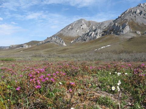
Classification
As already mentioned, tundra is a generalized concept. In fact, it is subdivided into three main zones: arctic, middle and southern. Let's consider them in more detail.
Arctic tundra. This subzone is (mostly) herbaceous. It is characterized by cushion-shaped shrubs and mosses. There are no “correct” shrubs. It has a lot of clayey bare areas and mounds of permafrost heaving.
Middle tundra(it is called typical) predominantly mossy. Near the lakes there is sedge vegetation with modest grasses and grasses. Here you can see creeping willows with dwarf birches, lichens, hidden mosses.
Southern tundra- This is mainly a shrub zone. The vegetation here depends on longitude.
Climate
 The climate here is rather harsh (subarctic). That is why the fauna in the tundra is very scarce - not all animals are able to withstand such strong winds and cold. Representatives of large fauna are very rare. Since the main part of the tundra is located beyond the Arctic Circle, winters here are not only much more severe, but also much longer. They do not last three months, as usual, but twice as long (called polar nights). It is especially cold in the tundra at this time. Continental climate dictates the severity of winter. In winter, the average temperature in the tundra is -30 ºС (and sometimes even lower, which is also not uncommon).
Usually, climatic summer not in the tundra (it is very short). August is considered the warmest month. The average temperature at this time is + 7-10 ° C. It is in August that vegetation comes to life.
Flora, fauna
The tundra is the kingdom of lichens and mosses. Sometimes you can find angiosperms (more often these are low grasses), low shrubs, dwarf trees (birch, willow). Typical representatives of the animal world are fox, wolf, bighorn sheep, hare, lemming. Birds are also found in the tundra: white-winged plover, Lapland plantain, snowy owl, plover, snow bunting, red-throated pipit.
The tundra is the "end of the earth", the reservoirs of which are rich in chir, omul, and nelma). There are practically no reptiles: due to low temperatures, the vital activity of cold-blooded is simply impossible.


