| Motto: “We are a fortress (swati Siyinqaba) " |
|
| Hymn: "Nkulunkulu Mnikati wetibusiso temaSwati" | |
|
|
| Independence date | September 6, 1968 (from) |
| official languages | English, Swati |
| Capital | (official) (royal and parliamentary) |
| Manzini | |
| Form of government | dualistic monarchy |
| King Prime Minister |
Mswati III Barnabas Sibusiso Dlamini |
|
Territory Total % water surface |
153rd in the world 17,363 km² 0,9 |
|
Population Assessment (2009) Density |
1,185,000 people (154th) 68.2 people / km² |
|
Gdp Total (2011) Per capita |
$ 4.1 billion (par) $ 3400 |
| HDI (2013) | ▲ 0.536 (low ; 141st place) |
| Currency | lilangeni (SZL, code 748) |
| Internet domain | .sz |
| ISO Code | SZ |
| IOC code | SWZ |
| Telephone code | +268 |
| Time Zones | +2 |
Kingdom of Swaziland(eng. Kingdom of swaziland, Swati Umbuso weSwatini) - the state in. In the south, southeast, west and north it borders with (border length - 430 km), in the east - with (105 km). The total length of the border is 535 km. The total area of the country is 17,363 km² (land area - 17,200 km²). The country lies on the Weld Plateau, which slopes down from west to east. The most high point- Mount Emlembe (1862 m). Swaziland has several gentle plains. The main rivers are Umpilusi (Great Usutu), Komati, Umbeluzi. The main Natural resources: coal, timber, hydropower potential, there are small deposits of gold and diamonds. About 11% of the territory is occupied by arable land, meadows and pastures - 62%.
Symbolism
Flag
Description state flag: three horizontal stripes of blue (top), red (triple width) and blue; the red stripe has an orange border; in the center of the red stripe there is a large black-and-white shield, two spears and a staff, decorated with feather tassels, horizontally.
Coat of arms
In the center of the coat of arms is a shield supported by a lion, symbolizing the king, and an elephant, symbolizing the queen mother. Above the shield is the headdress worn by the king during the Inkvala festival. At the bottom there is a ribbon with the national slogan.
Geography

Swaziland Map
Swaziland provides big variety natural landscapes, from mountainous areas along the border to savannas in the east and wet forests in North-west. Several rivers flow through the country, including largest river Swaziland - Lusutfu River.
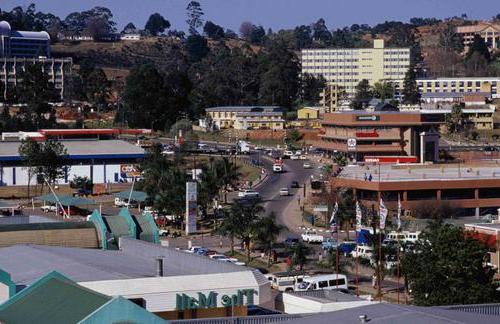
The official capital of the country - (67,200 inhabitants in 2004), the historical capital and seat of the Queen Mother and Parliament -. The largest city and economic “capital” is Manzini (73,000 in 2004).
Climate
The three-stage relief of the country corresponds to three main climatic zones... The moderately warm mountain climate is replaced by a lower subtropical and, finally, tropical in the Lower Velda. There is more precipitation in the summer. temperate zone. average temperature July 12 ° С, February - 23 ° С. Precipitation ranges from 500-700 mm per year in the east to 1200-1400 mm in the west.
Vegetable world
The vegetation of Swaziland is represented by a typical savanna in the west, thickets of xerophytic shrubs are common in the east. The flora is rich: about 2,400 species are known - from lichens and ferns to magnolias and ficuses. Some aloe - 25 species, 12 species of orchids, 10 - lilies.
Animal world
Large mammals include "blue" buffaloes, markhorses, zebras, hippos. Crocodiles are found in the rivers.
History
The ancestors of the Swazi people came to the south in the Middle Ages, from the central part of the continent. First they settled on the coast Indian Ocean However, in the 18th century, the Swazis were pushed back by other tribes to the north, into what is now Swaziland. V early XIX For centuries, the Swazis waged bloody wars against the Zulu and other neighboring tribes who raided the Swazi lands.
In 1836, the Swazi leader Sobhuza (now called the king) won a decisive victory over the Zulu, introduced a centralized system of his power, subjugating other leaders, and in fact created the Swazi state.
The next Swazi king, Mswati I, annexed new lands in the north of the country in the late 1830s and created a state whose territory was more than twice the area of modern Swaziland.
Boers came to Swaziland from the middle of the 19th century. They bought up large plots of land from the Swazi leaders for private ownership. Then, in 1894, the territory of Swaziland was declared part of the Boer Republic of the Transvaal.
After the Anglo-Boer War of 1899-1902, it declared Swaziland its protectorate, retaining the power of local kings and leaders there.
In 1964, the first local parliamentary elections were held in Swaziland. The majority of the seats were won by the party created by the then King Sobhuza II, the Imbokodwo National Movement.
The official languages are English and Swazi.
The urban population is 25%.
The literacy of the population is 82% (2003 estimate).
- 0-14 years old - 46% (men 245 626; women 247 825)
- 15-64 years - 52% (men 270 308; women 291 884)
- 65 years and older - 2% (men 11 357; women 16 289)
The main religion in Swaziland is Christianity (82.7% of the population), in which various Protestant and local African churches, including African Zionists, constitute the majority, and there is also a significant number of Roman Catholics.
Other religions include Islam (0.95%), Bahaism (0.5%), Hinduism (0.15%), and traditional beliefs such as animalism, fetishism, the cult of ancestors, the forces of nature, etc.
As of May 2010, Swaziland is the country with the highest percentage of people infected with the human immunodeficiency virus (HIV). Every fourth adult resident of the country is a carrier of the virus.
Economy
GDP per capita for 2011, par - 3.4 thousand dollars (150th place in the world, 8th place in Black Africa). Below the poverty level - 69% of the population (in 2006). The unemployment rate is 40% (in 2006).
75 % work force the country is employed in agriculture (8% of GDP). They grow sugarcane, cotton, corn, tobacco, rice, citrus fruits, pineapples, sorghum, peanuts, and also livestock (cows, goats, sheep).
In the industrial sector of the economy (45% of GDP) - sugar cane production, coal mining, timber production, production of fruit juice concentrates, production.
The budget deficit is 16% of GDP. The negative trade balance increased from USD 153 million (2008) to USD 194 million. The inflation rate was 7.8%. Unemployment is 40.6%. The country's foreign exchange reserves are estimated at $ 920 million (January 2010). The volume of external debt is USD 367 million.
Exports - $ 1.8 billion (in 2008) - juice concentrates, sugar, timber, cotton, citrus fruits, canned fruits.
The main foreign trade partners are South Africa (60% of exports and over 80% of the country's imports).
Imports - $ 1.9 billion (in 2008) - manufactured goods, vehicles, food, oil products.
The main supplier is South Africa (90%).
Included in an international organization ACP countries.
Economy, transport communications
The main sector of the economy is agriculture (about 8%), which employs most of the able-bodied population. The main crops are sugarcane, corn, cotton, tobacco, rice, citrus fruits, pineapples. In addition to the processing of agricultural products, the mining industry (coal and asbestos) and the production of cellulose are developed. GDP in 1994 was $ 3.3 billion (GDP per capita - $ 3490). The monetary unit is lilangeni (1 lilangeni (E) is equal to 100 cents). Main trading partners: South Africa, Japan, Belgium, Great Britain, Canada.
Total length railways- 297 km, highways - 2853 km (510 km - paved roads).
Culture
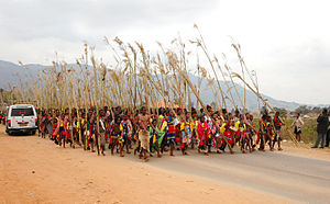
The Umhlanga ceremony, where tens of thousands of Swazi virgins dance in front of the king. Mbabane, 2006.
A tourist attraction is the traditional Reed Dance (Umhlanga), an annual mass celebration in Swaziland.
Swazi Anthem:
Nkulunkulu Mnikati wetibusiso temaSwati;
Siyatibonga tonkhe tinhlanhla,
Sibonga iNgwenyama yetfu,
Live netintsaba nemifula.Busisa tiphatsimandla takaNgwane
Nguwe wedvwa Somandla wetfu;
Sinike kuhlakanipha lokungenabucili
Simise usicinise, Simakadze.
mass media
State TV company Swazi tv (Swaziland Television Broadcasting Authority- "Swaziland Television Broadcasting Authority"), until 1983 - STBC ( Swaziland Television Broadcasting Corporation- "Swaziland Television Broadcasting Corporation"), includes the TV channel of the same name, the state radio company - Radio Swaziland, includes the radio station of the same name.
see also
- Islam in Swaziland
- Music of Swaziland
- Swaziland University
Swaziland is a wonderful and amazing state located in southern Africa. The African continent is still largely a mystery to European residents.
Swaziland is a state that combines the traditions of Aboriginal and European. Local people, Swazis, are highly respected. The government is doing everything to ensure that their family flourishes for as long as possible, and does not disappear from the face of the Earth. As for religion, most of the local residents still adhere to Christianity, and not the traditional Swazi beliefs. However, both religions are equally respected.
Swaziland has two capitals, and so far it is difficult to single out a more official one. The capital of Swaziland, Mbabane, has administrative significance. The government building, most of the banks, and various business institutions are located here. It cannot be said unequivocally that it will be interesting for a tourist to stay here, but it is still worth taking a walk along the incredibly beautiful streets. The modern streets Mbabane Alley, New Alley and Allister Miller can be considered some kind of attractions. The history of the emergence of Allister Miller Street is especially interesting. She was named after the first European to be born in Swaziland. His homeland was the capital of Swaziland, Mbabane.
Also worth a visit is Swazi Square - a huge shopping mall... There you can buy a variety of gizmos for a reasonable fee. By the way, goods in Swaziland are much cheaper than in the rest of Africa.
Also in Mbabane is the National University.
The second capital of Swaziland is Lobamba. It can be called a real treasure cultural heritage that Swaziland keeps within itself. This city is the location of the king's residence, in addition, the highest legislative body of the country, the bicameral parliament, sits here. We can say that those decisions about the political system in the country, which are made by the government in Mbabane, are approved in Lobamba. Lobamba reflects the culture, peculiarities of the country. No joke, you can even meet the king here! For this, Lobamba is revered as the capital: Swaziland, therefore, has two of them.
In Lobamba, the national dances of the Inkvala ceremony and the Umlanga dances are held. You can see the king at such events. And not just to see, but to catch those taking part in. Can every state boast of this?
If you want to explore the culture of the locals, you should visit National Museum which displays all the customs of the aborigines. Also, here you can explore the culture of the country from start to finish. A place like the Cultural Village is also noteworthy. It shows the conditions in which the local residents lived and how they live at the present time. Lobamba is a real highlight of the state, the cultural center of the state of Swaziland. The capital of the country, equal in importance to Mbabane, is the most attractive place for tourists and those who are interested in the peoples of Africa.

Swaziland is thus a unique state. After all, two cities at once are revered as the capital of Swaziland.
SWAZILAND
(Kingdom of Swaziland)
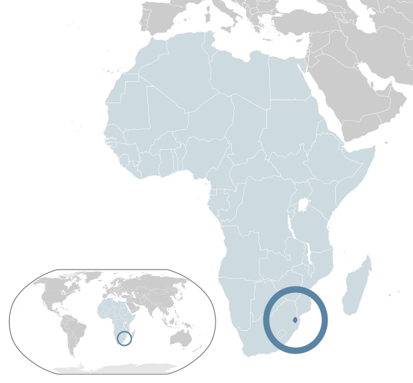
Geographical position... Swaziland is a state in the southeast of Africa. In the east it borders with Mozambique, in the southeast, south, west and north with South Africa.
Square. The territory of Swaziland is 17,363 sq. km.
Gchavny cities, Administrative division... The capital of Swaziland is Mbabane (administrative), Lobamba (royal residence). Largest cities: Man-zini (53 thousand people), Mbabane (47 thousand people).
Swaziland is a constitutional monarchy. The head of state is the king. The head of government is the prime minister. Legislature is a bicameral parliament (Senate and House of Assembly).
Nature
Relief. In the west of the country there is Mountain chain, rising to 1 220 m, in the center there is a plateau, the average height of which is about 610 m, the east of the country is occupied by a low-lying veldt.
Geological structure and minerals. The bowels of the country contain reserves of asbestos, gold, diamonds.
Climate. The climate of the country is transitional from subtropical to tropical, wet in summer... Average monthly temperatures from + 12 ° С to + 20 ° С. Precipitation ranges from 500 - 700 mm in the east of the country to 1 200-1 400 mm and more in the west.
Inland waters... The main rivers of the country are the Komati, Bolshoy Ustu and Umbeluzi.
Soils and vegetation. The vegetation in the west is typical savanna with acacia and baobabs, in the east thickets of xerophytic shrubs prevail.
Animal world... The fauna is typical for the African savannas: blue buffaloes, horned antelopes, zebras, hippos, crocodiles in rivers.
Population and language
The population of Swaziland is about 966 thousand people, the average population density is about 56 people per 1 sq. km. Ethnic groups: Swazi - 90%, Zulus - 2.3%), Europeans - 2.1%. Languages: Swazi, English (both state).
Religion
Believers are mostly Christians, a third of the population adhere to local traditional beliefs.
A brief historical outline
The Swaziland Royal House has been known for over 400 years and is one of the oldest in Africa. V late XIX v. after the Boer War, Swaziland came under the control of the Union of South Africa. In 1907, Swaziland was transferred to the jurisdiction of the British High Commissioner South Africa... In 1967, the country received the right to self-government, and on September 6, 1968 - full independence. In 1973, the constitution was abolished and political activity was prohibited. For four years after the death of King Sobuza II, there was no ruler in the country - it was decided which of the 67 sons of the monarch should take the throne. This problem was resolved in 1986.
Brief economic outline
Economically underdeveloped agrarian country. Main crops: corn, sugarcane, citrus fruits, pineapples, cotton. Driving pasture animal husbandry. Mining of asbestos, coal, iron ore... Artificial plantations have been created on the site of the cleared primary forests. Logging. Sugar, woodworking, fruit canning factories. Exports: sugar, canned fruits, meat, timber, asbestos.
The monetary unit is lilangeni, in free circulation also the South African rand.
A brief outline of culture
Art and architecture. Lobamba. National Museum of Swaziland; Parliament building; the village of the queen mother.
It is not clear which city is considered the main one in this African state. On the one hand, it is known that the official capital is, at the same time, administrative center district with a funny name for our ear Hoho. On the other hand, all sources indicate that there is a second, royal and parliamentary capital, the city.
The famous Wikipedia reports very little information about the capital of the state, located in the southeastern part of the Black Continent. First, it is known that Mbabane is one of the smallest capitals in the world, its population does not even reach 100 thousand people. Secondly, the original purpose of the settlement was a fortress, founded on the border of the 17th - 18th centuries. and served local residents shelter from numerous external enemies. Third interesting fact- A fairly large asbestos deposit was discovered near the Swaziland capital, and its active development is now underway.
One more amazing fact- the capital of Swaziland has as many as two sister cities. One of them is quite famous, located in the Republic of China, the second is (USA).
Natural and cultural attractions
Mbabane may have bright prospects, but today the capital of Swaziland is not very interesting for tourists. On the one hand, this is due to the fact that there are practically no interesting historical sites and monuments in the city. On the other hand, the city cannot boast of the presence of modern architectural masterpieces that could attract travelers from all over the world. To do this, you need to go to the second capital - Lobamba, to see, for example, the Embo Royal Palace - from the name it is clear that this is the residence of the head of state.
Among the natural attractions located in the vicinity of Mbabane, the guests of the country point out: the natural park and reserve Malolotzha. Nature Park having beautiful name Mlilvane, located in scenic location- Surrounds the jagged peak of Nyonyan. Traveling around the area, you can meet zebras and giraffes, crocodiles and hippos. The park is also home to a large number of birds, the main one being the purple loris - the national symbol of Swaziland.
The Malolotzha nature reserve is located 20 kilometers from the capital, which is named after the most beautiful local waterfall. Descriptions of the reserve, which can be found in booklets, cannot be compared with what tourists can see in reality. Rare birds and plants, unique natural landscapes, cultivated paths and modern recreation camps are at the service of travelers.
Useful data for tourists about Swaziland, cities and resorts of the country. As well as information about the population, currency of Swaziland, cuisine, peculiarities of visa and customs restrictions in Swaziland.
Geography of Swaziland
Kingdom of Swaziland - small state in southern Africa, bordering South Africa in the west and Mozambique in the east.
The surface of Swaziland is a highland descending eastward to the coastal plain of Mozambique in three steps: High Weld (1000–1500 m above sea level), Middle Veld (400–800 m) and Low Veld (150–300 m).
Located in the west, the High Weld is characterized by a rugged relief, with individual peaks exceeding 1800 m, the highest point being Mount Emlembe (1862 m). Medium Weld has a leveled surface and is good for farming. Low Veld is famous for its rich pastures and forests, in the east it is bounded by the Lebombo Mountains.
State
State structure
Swaziland is a constitutional monarchy, part of British Commonwealth... The head of state is the king. The legislature is a bicameral parliament (Senate and House of Assembly).
Language
State language: Swazi, English
Local dialects are widely used in the province.
Religion
Believers are mostly Christians (up to 60%), up to 40% of the population adhere to local traditional beliefs.