Bondarev N. D.
Arkhyz and Bolshaya Laba. -M, 2002.
Foreword
Features of travel in spring and summer
Pages of history
B. Laby Valley
M1. Kurdzhinovo - pos. Phia.
M2. To the sources of the Big Laba.
MH. Ashirhumara
M4. To the Labinsky glacier.
Zagedan
M5. To Zagedan lakes (20 km, 1.5 days)
Other routes
Phia
M6. Rechepsta River - lane. Phiya - pos. Phia (23 km, trail, 1 day)
M7. Phiya village - r. Phia - lane. Urup-Phiya - at the source of the river. Atzgara.
Stormy and Azimba
M8. B. Laba River - r. Stormy - lane. Vorontsova-Velyaminova - l. Azimba - r. Azimba (25 km, 2 days)
M9. Burnaya River - lane. Duritsky - r. Amanauz (17 km, 1 day)
From the upper reaches of B. Laba
M10. B. Laba River - lane. Tsegerker - lane. 46th Army - lane. Alashtrakh, trail, 12 km, 1 day.
M11. Glacier Labinsky - lane. Psyrs - lakes Psyrs (1.5 days)
Sanchara
M12. Phiya village - r. Sanchara - lane. Sanchara - lane. Hell-zapsh, trail, 2 days.
M13. Glade 7th post - mineral springs Adzapsh-per. Adzapsh.
M14. Mineral springs Adzapsh - trail along the GKH ridge - lane. V. Damkhurts - river valley. Damkhurts (trail, 2 days).
M15. B. Laba River - lane. Abgytskha - left source of the river. Abgytskha (20 km, 1.5 days)
Other routes
Maker
M16. Phiya village - r. Maker - lane. Maker (trail)
Mamhurz
M17. Damkhurts settlement - r. Mamkhurts - "Seven Lakes" (4-5 days)
Other routes
Damkhurts
M18. The village of Damkhurts - lane. Damkhurts
Other routes
Big Zelenchuk. Arkhyz
On the way to Arkhyz
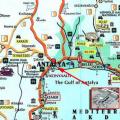
M19. Stanitsa Zelenchukskaya - aul Arkhyz (highway, 48 km).
M20. Lower Ermolovka - Krivaya gully - Shpil settlement - r. Kafar (trail, 1-2 days).
M21. Monuments of Lower Arkhyz (1 day).
M22. To the Savior Not Made by Hands
M23. Lower Arkhyz - Jeti-Karasu tract - Large azimuth telescope.
M24. Climbing Mount Pastukhovaya (2733 m, 4 h)
Other routes
In the vicinity of the aul Arkhyz
M25. Medieval Alan settlement (excursion for 4 hours).
M26. Barite beam - str. Abishira-Akhuba (8 hours).
M27. Rock Karcha-Tebe - per. Byoryu-aush
M28. Arkhyz horizon (6 hours).
M29. Cossack glade - lakes Morkh-Syrty - lane. Ozerny.
M30. Climbing Mount Krasnaya (trail, half a day)
Other routes
Valley of the Arkhyz River
M31. Aul Arkhyz - b. Arkhyz (19 km, road).
M32. Arkhyz river - Gabulu-Chat plateau - Smirnova -r. Psysh (2 days, trail).
M33. Dukka River - lane. Ayulu - r. White - r. Psysh (26 km, 2 days).
M34. Dukka pass - r. Burnaya - r. B. Laba.
M35. Fedoseev pass (1 A, 2880 m).
M36. Rechepsta River - lane. Atsgara - b. Hatsgara (trail, 17 km).
Other routes
Psysh
M37. Valley of the r. Psysh - lake. Naurskoe (trail, 31 km).
M38. Pass Naur (1 A, 2839 m).
M39. Pass Magana - Lake Psyrs - lane. Bearish.
M40. Pass Pshish
M41. Sekirtme river - lane. Chuchkhur - Green Lakes - lane. Rabbit ears or lane. Kholodovsky - r. Psysh (3 days)
M42. Bush Glacier - lane. Kizgych False - lane. Chuchkhurskaya Shchel - per. Chamagwara.
M43. Glacier Psysh - lane. Tokmak and per. Psysh.
Other routes
White and Amanauz
M44. White River (Ayulu) - lane. Dorbun - the source of the river. Stormy
M45. Gorge r. Amanauz - lane. Tornau and lane. Bear-Labinsky glacier.
M46. Amanauz river - lane. Poachers - r. Burnaya (9 km)
M47. Amanauz and Azimba passes
Other routes
Sofia
M48. Aul Arkhyz - b. Sofia - Ice farm (road, 16 km).
M49. Sofia waterfalls(half day excursion) leave an unforgettable experience.
M50. Pass Sofia Saddle (2640 m)
M51. Glacier farm - r. Ak-Ayry - lane. Bash-Jol -r. Psysh (20 km, 1 day)
M52. Ak-Ayry river - lane. Topal-Aush (Kozhukhova) - Green Lakes (2 days)
M53. Ak-Ayry glacier - lane. Ak-Ayry - r. Kyshlau-su (1 day)
M54. Climbing Mount Nadezhda (1A, 3355 m, 10-12 h)
M55. Ak-Ayry river - lane. Kel-Aush - Upper Sophia lakes - the city of Kel-Bashi - r. Ak-Ayry (2-3 days)
M56. Valley of the r. Sofia - Gammesh-Chat lakes (excursion, 15 km)
M57. Sofia River - lane. Eaglet - Lake Crater - Lake Comma - Kashkha-Echki-Chat lakes - r. Sofia (16 km, 2 3 days)
Other routes
Kizgich
M58. Aul Arkhyz - b. Kizgych - Kshgych-Bash tract (trail, 3-6 days).
M59. Kizgych-Bash tract - Besh-Chuchkhur waterfall - Green lakes (one-day excursion).
M60. Passes Kizgych and Satkharo
M61. Kizgych-Bash tract - river valley. Salyngan - l. Salyngan (one day excursion)
M62. Lake Mironov (excursion for 6-8 hours)
M63. Passes Kongur, Salyngan, Chvakhra
M64. Baga-Tala tract - lane. Bugoychat - r. Marukh (14 km)
M65. Pass of the 810th Rifle Regiment (1 B, 3000 m)
M66. Pass Kurella - lane. Chvakhra - lane. Kongur - lane. Satharo - trans. Kizgych False
Kyafar-Urup. Abishira-Akhuba
M67. Stanitsa Zelenchukskaya - Stanitsa Watchtower - pos. Leso-Kyafar
M68. Stanitsa Zelenchukskaya - r. B. Zelenchuk - Generovskaya gully - r. Kyafar-Agur - forestry cordon
At the head of the Kyafar-Agur river
M69. Kyzylchuk ridge - Loose hillock - Agur lakes - lane. Fedoseeva - Arkhyz (trail, 4-6 days).
M70. Agursky lakes - lane. Agur - lane. Mylgval - Lake Kyzylchuk (1-1.5 days).
M71. River Zap. Agur - lane. Kumbyzh - lake. Kyzylchuk - Lake Fish (trail, 4-5 hours).
Other routes
Kyzylchuk. Chilik.
M72. Loose hillock - Kumbyzh tract - r. Kyzylchuk -oz. Rybnoe - lane. Rechepsta - r. Arkhyz (3-4 days)
M73. Lake Rybnoe - lane. Kynkhara - lake. Chilik - lane. Chilik - b. Arkhyz (1.5-2 days)
M74. Lake Rybnoe - lane. Kyzylchuk - Lake Chilik - lane. Psykela - r. Hatsgara - Glade of poppies (2-3 days)
M75. Traverse hr. Abishira-Akhuba from the lane. Chilik to lane. Rechepsta
M76. Pass Kafar-Rechepsta (1A, 3000 m)
M77. Pass Kafar-Arkhyz (1 A *, 3000 m)
Other routes
Atzgara
M78. Atsgara River - lane. Zagedan - b. Zagedanka - b. B. Laba (1-1.5 days).
M79. Glade of poppies - lane. Kabanly - r. Zagedanka -r. B. Laba
M80. Glade of poppies - lane. Kyrthua - r. Zagedanka -r. B. Laba (1.5 days)
To the sources of the Urup River
M81. The village of Urup - ridge. Akshirsky - the upper reaches of the river. Urup -r. Zagedanka (trail, 3-4 days)
M82. Grand Urup canyon
M83. Pass Urup-Atsgara (1 A *, 3000 m)
Other routes
Brief toponymic dictionary
FOREWORD
The Western Caucasus is one of the most popular mountain tourism regions, which experienced a decline in attendance in the 90s, as did the entire Caucasus as a whole. V last years tourists and climbers began to return here. Convenient approaches, varied, technically interesting passes and peaks, many alpine lakes - all this attracts lovers of mountain travel.
The last book on this area was the guide "Mountain travels in the Western Caucasus" (V.V. Arsenin, ND Bondarev, E. D. Sergievsky. M: FiS, 1976). Since then, in Zap. The Caucasus has undergone major changes.
The routes to the southern slopes of the Main Caucasian Ridge (GKH) were cut off due to the appearance of the state border, new routes were developed on the northern slopes. There was a need for a new guidebook, and it was decided to publish it in two books: "Arkhyz. Big Laba" (ND Bondarev) and "From Marukh to Elbrus" (V.V. Arsenin). They continue the series of guidebooks "Elbrus and its spurs" and "South of Baksan" (A. A. Alekseev).
In the guidebook for each valley, firstly, the paths of approaches are described, then the pass routes to the neighboring gorges. By joining separate sections, you can create multi-day routes of various categories of difficulty. Descriptions of the passage of the passes are mainly tied to July - August. Off-season travel (April - May, October - November) has a separate section. Techniques for overcoming mountainous terrain, with rare exceptions, are not given.
Due to the rare visit of some valleys, the descriptions of individual sections may not correspond to the specific situation, first of all, due to the condition of the paths, bridges and the location of the kosha. In recent years, an intensive melting of glaciers has been observed in the Caucasus, which is why already in August, even on the slopes of the northern exposure, large areas of open ice open up, and the danger of rock falls increases.
In the descriptions, the indications "left" and "right" are used in the orographic sense, when the observer looks downstream of the river. Otherwise it is agreed.
Currently, the area has become a border area. To visit it, especially near the border with Abkhazia, a permit is required, which can be obtained in advance at the address: 357100, Karachay-Cherkess Republic, Cherkessk, st. Leonova, 2, military unit 2011.
At the end of the book, there is a list of literature that allows you to get to know more about the nature and history of the area.
In the guide, the chapter "General Geographical Information" was written jointly with V.V. Arsenin. E. A. Alperten and E. A. Chernopyatov took part in the descriptions of the routes. A. Kovalenko, A. Kozhukhov, N. V. Koloshina, V. P. Kuznetsov, I. T. Kuznetsov, V. A. Lunin, P. F. Chirukhin, V. Ya. Fridlyand provided assistance in the preparation of the book. ... It should be noted the special role in the preparation of the guide by L.V. Wegener. He compiled a toponymic dictionary, described several routes, and made valuable comments on the text and diagrams.
The guide uses photographs by E. A. Alperten, N. D. Bondarev, V. A. Zheltyakov, N. Yu. Kretov, A. V. Pavelchik and E. A. Chernopyatov. At the final stage of preparing the book, V. A. Kozhin, V. V. Konyshev, L. V. Turkina, E. A. Chernopyatov did a great deal of technical work.
GENERAL GEOGRAPHICAL INFORMATION
The Western Caucasus is the region of the Caucasus to the west of Elbrus with borders along the upper reaches of the Kuban and Nenskra. In a narrower sense to Zap. The Caucasus includes the area that includes a high-mountainous, glacier-covered section of the Main Caucasian Ridge (GKH) with a length of about 200 km. Located to the west, the lower mountains belong to the North-West. The Caucasus.
The guide covers part of the Zap. Caucasus with mountains in the upper reaches of B. Zelenchuk, B. Laba, Kyafar-Agur and Urup. Administratively, this territory belongs to the Karachay-Cherkess Republic, Stavropol and Krasnodar Territories... The most high peaks district - Pshish (3790 m) and Sofia (3640 m).
To the north of the GKH there are spurs separated by deep valleys of the tributaries B. Zelenchuk and B. Laba. At a distance of about 20 km from the GKH, the ridge is located parallel to it. Abishira-Akhuba, belonging to the system of the Advanced (Lateral) ridge. By the way, Elbrus (5642 m) also belongs to it. Farther north, along the Peredovoye, stretches the Rocky Ridge (height about 2000 m), which has gentle northern slopes. To the south of the GKH are the Bzybsky and Chkhaltsky ridges. Their spurs, cut by deep canyons of the Amtkel, Jampal, Kelasuri and Gumista rivers, are gradually disappearing towards the Black Sea coast.
The rivers of the northern slope of the GKH cut through the Lateral Ridge with narrow gorges, and in the upper reaches, many valleys have vast hollows. The rivers originate from glaciers and snowfields, the maximum water falls in the summer, most of the rivers are clean and transparent.
The mountain river is a serious obstacle. The crossing is especially difficult in rainy weather, when the water level rises noticeably. In the Caucasus, where there is a rather dense network of roads and paths, there are bridges across almost all major rivers. The route must be tied to them. Shepherds arrange luggage, temporary bridges and over large streams. You can learn about the state of these crossings in villages, koshas.
There are many lakes in this region. At the height, the largest of them lie in carats left by ancient glaciers. Many small tar and moraine lakes (some with ice until the end of summer) give these mountains a special charm.
The higher the mountainous country is raised, the deeper and more ancient stone layers are exposed, come out into view as a result of weathering and erosion of rocks. When traveling through the valleys of the Kuban, near Cherkessk, near the river, Quaternary deposits and sedimentary rocks of the Tertiary period (up to 65 million years old), beyond Ust-Dzhegutinskaya - the Cretaceous period (up to 140 million years). Then, at the entrance to Karachaevsk and beyond, you cross a wide belt of Jurassic rocks (up to 200 million years old).
On the seismic map of the country, the Caucasus is assigned to the 7-8 point zone. An earthquake in the mountains is dangerous due to the occurrence of rockfalls, collapse of cornices and mudflows. A strong earthquake, called Chkhaltsky, occurred on July 16, 1963. Its epicenter was near the village of Ptysh, which caused great destruction. The rockfall led to a tragedy in a group of climbers on the wall of the Dombai-Ulgen mountain.
On the southern slope of the GKH, where at that time there was a thunderstorm with a shower, landslides occurred. As a result, the road to the village was destroyed in several places. Chkhalta. A landslide blocked the upper reaches of the river. Ptysh. The river swept away the barrier mudflow washed away the banks and tumbled down the forest.
Although strong tremors are rare, the likelihood of them forces one to carefully approach the choice of the bivouac site, critically assessing it (including the finished sites) from the point of view of rockfall.
The climate of the region is influenced by two factors: proximity to the Black Sea and a chain of high mountains. The influence of the sea is stronger on the southern slopes, which intercept a significant part of the moisture from warm westerly and southwestern winds. At their foot and on the coast, about 1500 mm of precipitation falls annually. The amount of precipitation increases with height, reaching 3000 mm and more. In winter, there is a lot of snow at moderate altitudes; in the highlands, the thickness of the snow cover reaches several meters.
The northern slopes are colder and drier. When crossing the GKH, this difference is very noticeable. With the rise in the mountains, the temperature drops, and the amount of precipitation increases. In Teberda, located at an altitude of about 1300 m, average temperature July +15.6 "C, January ~ 4" C, about 700 mm of precipitation falls per year.
In Dombai (1630 m), the temperature is several degrees lower, and the precipitation is twice as high. According to long-term observations at the Klukhorsky Pass meteorological station (2037 m), the snow cover reaches 2 m, and on the sub-peak slopes it reaches 4 m. The rainiest months are May and June. The relatively dry season lasts from August to October. In August, frosts are not uncommon at an altitude of 2500 m.
Over the past hundred years, the area of most glaciers has decreased by about a quarter, and their number has increased due to crushing (although some small ones have disappeared altogether). The average thickness of the tar glaciers is 25-30 m, and of large valley glaciers - 100 m. The glaciers continue to retreat, moraines are covered with grass and bushes. The Caucasus is characterized by the proximity of glaciers and bright greenery. Azalea blooms in the Khetskvara gorge in July, a few dozen meters from the glacier.
Avalanche danger occurs in late autumn in October - November, when snowfalls begin. Dry snow avalanches occur during or immediately after heavy snowfalls (70-100 mm per day). During the period of blizzards, snow slabs form. In cold winters with little snow, an avalanche can be caused by the formation of a fragile layer of deep rime. With the transition of the average daily temperature over 0 ° С in March - April, the time of descent of wet avalanches begins. They are possible in winter during thaws. A massive avalanche usually ends by May, but in the highlands this period is delayed. On snowy slopes and under cornices, avalanche danger persists all year round.
Avalanche cones remain at the foot of the slopes until the middle, and in shaded areas until the end of summer. The danger of avalanches also exists in the middle mountains: avalanche centers, although rare, are known near Teberda and Arkhyz. Particular attention to avalanche hazards is required when traveling in spring (May) and autumn.
Entering the mountains from the north, you first cross the belt of deciduous forests, starting at an altitude of 500-600 m. Its lower floor (up to 900-1000 m) is occupied by oak-hornbeam forests with hazel, ash, pear, and the upper (up to 1400 m) - beech. In wide developed parts of the valleys, such forests are found as islands, but they completely cover the steep, inaccessible slopes of the gorges. Alder and willow grow along the river banks. Dark coniferous forests (fir, spruce) are located at altitudes from 1200-1400 m to 2200 m. The dry sunny slopes and cliffs are covered with pine trees.
Above is the subalpine belt, the limits of which range from 1800 to 2500 m. Above the edge of the tall-trunk forest, there is a strip of beech, birch, maple crooked woods. Here, thickets of rhododendrons spread, the bushes of which bloom at different times, and its white or cream inflorescences can be seen almost all summer. Even higher are tall-grass meadows as tall as a man. Here is the kingdom of flowers: orange elecampane, blue bells, white daisies, pink mallows, yellow lilies, raspberry clover. In the middle of the sea of flowers, the three-meter-long umbrellas of the cow parsnip rise. Touching it causes burns that do not heal for a long time.
On gentle slopes, where livestock graze, the herbage is poorer. Here stands out thickets of horse sorrel and poisonous hellebore. In alpine meadows (2500-3200 m), short grass does not hide stones. The floral carpet is filled with bright blue hyacinths, purple primroses, yellow buttercups, pink asters, and purple bells. Grass and flowers also grow on rocky shelves high above the snowfields and ice.
The fauna includes over 40 species of mammals and 120 species of birds. Wild boar, roe deer, Caucasian deer, fox, lynx, jackal, marten are found in the forests. The brown hare is everywhere. The Altai squirrel introduced in 1937 has spread. There are also wolves. In the Caucasian and Teberdinsky reserves, work is underway to restore the herd that was exterminated at the beginning of the 20th century. Caucasian bison. In summer, the brown bear keeps at the border of the forest, where you can stumble upon a bed left by it. It also enters the valleys, especially the raspberries. On the grassy ledges near the forest, you can see a herd of chamois, and on the rocks in the upper reaches of the gorges - tours. Turi "paths" go along barely noticeable ledges and ledges, traces of tours are also found on snowfields. It is dangerous to be below these animals, because stones can fall from under the hooves!
Among the birds of the forest and meadow belts, there are both common for the middle zone - jay, woodpecker, cuckoo, and mountain birds - stone partridge (partridge), griffon vulture, black vulture. In the highlands lives the ular (large gray turkey) and the black alpine chough with a yellow beak, living near glaciers and snowfields.
Of the reptiles, lizards, snakes, copperheads, steppe and Caucasian vipers are found (up to the rocks of the alpine belt). Caucasian viper, endemic to Zap. Caucasus, occurs up to an altitude of 2500 m in glades and overgrown talus. In the subalpine zone, the viper keeps near rocks and talus. It can be of different colors, but it is characterized by a wide black zigzag stripe on the back. The snake is difficult to distinguish among dry fern leaves or lichen-covered stones.
Trout is found in rivers and in some lakes.
On the West. In the Caucasus, there are reserves - Caucasian and Teberdinsky (with a branch in Arkhyz). A permit is required to stay in them. In the gorges (B. Zelenchuk, Urup, B. Laba, etc.), reserves have been created where hunting, fishing and picking berries are prohibited.
The foothills and valleys, suitable for agriculture and gardening, are densely populated. The main type of economic activity is cattle breeding. The transfer of livestock to mountain pastures takes place in May-June, the season usually lasts until September. For temporary residence there are traditional koshas - huts made of logs, stone, shreds or twigs, and tents.
The meadows in the valleys where there are roads are used for hayfields. The highlanders value them, cleanse them of stones and fence them off. In no case should you trample the grass, shortening paths, bivouac on it and scatter stones.
Geographic terms and concepts. Geographic definitions. Absolute height Is the vertical distance from sea level to a given point. points above sea level are considered positive, below - negative.
Azimuth- the angle between the direction to the north and the direction to any object on the ground; is calculated in degrees from 0 to 360 ° clockwise.

Iceberg- a large block of ice floating in the sea, lake or aground.
Antarctic belt- descends from the South Pole to 70 ° S latitude.
Anticyclone- the area of increased air pressure in the atmosphere.
Area- the area of distribution of any phenomenon or group of living organisms.
Arctic belt- descends from the North Pole to 70 ° N.
Archipelago- a group of islands.
Atmosphere- the air shell of the Earth.
Atoll- a coral island in the form of a ring.
Beam- a dry valley in the steppe and forest-steppe regions in the Russian Plain.
Barkhan- an accumulation of loose sand, blown by the wind and not fixed by vegetation.
Swimming pool- an area of depression that does not have a runoff on the surface.
Shore- a strip of land adjacent to a river, lake, sea; slope down to the water basin.
Biosphere- one of the shells of the Earth, includes all living organisms.
Breeze- local wind on the shores of seas, lakes and large rivers. Day breeze. (or marine) blows from the sea (lake) to land. Night breeze (or coastal) - from land to sea.
"Brocken Ghost"(on the Brocken mountain in the Harz massif, Germany) - a special kind of mirage observed on clouds or fog at sunrise or sunset.
Wind- air movement relative to the ground, usually horizontal, directed from high pressure to low pressure. The direction of the wind is determined by the side of the horizon from which it blows. Wind speed is measured in m / s, km / h, knots or approximately on the Beaufort scale.
Air humidity- the content of water vapor in it.
Watershed- the boundary between drainage basins.
Elevation- an area raised above the surrounding terrain.
Waves- oscillatory movements aquatic environment seas and oceans caused by the tidal forces of the Moon and the Sun (tidal waves), wind (wind waves), fluctuations in atmospheric pressure (anemobaric waves), underwater earthquakes and volcanic eruptions (tsunamis).
Highlands- a set of mountain structures with steep slopes, peaked peaks and deep valleys; absolute heights of more than 3000 m. The highest mountain systems of the planet: the Himalayas, Mount Everest (8848 m) is located in Asia; in Central Asia, in India and China - Karakorum, Chogori peak (8611 m).
Altitudinal zonality- change natural areas in the mountains from the bottom to the top, associated with climate and soil changes depending on the height above sea level.
Geographical coordinates- angular values that determine the position of any point on the globe relative to the equator and the prime meridian.
Geospheres- shells of the Earth, differing in density and composition.
Hydrosphere- the water shell of the Earth.
Mountain- 1) an isolated sharp rise in a relatively flat area; 2) a peak in a mountainous country.
The mountains- vast territories with absolute heights of up to several thousand meters and sharp fluctuations in heights within their limits.
Mountain system- a set of mountain ranges and mountain ranges, stretching in the same direction and having a common appearance.
Ridge- an elongated, relatively low relief form; formed by hills, lined up in a row and merged at their feet.
Delta- the area of deposition of river sediments at the mouth of the river when it flows into the sea or lake.
Geographic longitude- the angle between the plane of the meridian passing through the given point and the plane of the initial meridian; measured in degrees and measured from the prime meridian to the east and west.
Valley- negative linearly elongated landform.
Dunes- the accumulation of sands on the shores of seas, lakes and rivers, formed by the wind.
The bay- a part of the ocean (sea or lake), which juts out quite deeply into the land, but has free water exchange with the main part of the reservoir.
The earth's crust is the upper shell of the earth.
Swell- slight, with a calm, uniform wave, sea, river or lake disturbance.
Ionosphere- high layers of the atmosphere, starting at an altitude of 50-60 km.
Source- the place where the river begins.
Canyon- deep river valley with steep slopes and narrow bottom. K. submarine - a deep valley within the submarine margin of the continent.
Karst- dissolution of rocks by natural waters and the phenomenon associated with it. Climate is a long-term weather regime in a particular area. Local K., distributed over a relatively small area.
Climatic zone (or belt)- a vast region distinguished by climatic indicators.
Scythe- a sandy or pebble rampart, stretching along the coast or protruding in the form of a cape far into the sea.
Crater- a depression formed after the explosion of a volcano.
Ridge- a sharply uplifting large uplift, one of the types of uplands.
Avalanche- a mass of snow or ice falling down a steep slope.
Lagoon- a shallow bay or bay, separated from the sea by an oblique or coral reef.
Geographic landscape- type of terrain, a relatively homogeneous area of the geographic envelope.
Glacier- a mass of ice slowly moving under the influence of gravity along a mountainside or along a valley. The Antarctic glacier is the largest on the planet, its area is 13 million 650 thousand km2, the maximum thickness exceeds 4.7 km, and the total ice volume is about 25-27 million km3 - almost 90% of the volume of all ice on the planet.
ice Age- a period of time in the geological history of the Earth, characterized by a strong cooling of the climate.
Forest-steppe- a landscape in which forests and steppes alternate.
Forest tundra- a landscape in which forests and tundra alternate.
Lyman- shallow bay at the mouth of the river; usually separated from the sea by an oblique or in-fill.
Lithosphere- one of the shells of the Earth.
Mantle- the shell of the Earth between the earth's crust and the core.
Mainland- a large part of the land, surrounded on all sides by oceans and seas.
Australia- in the Southern Hemisphere, between the Indian and Pacific Oceans (the smallest of the continents);
America North and South- in the Western Hemisphere, between the Pacific and Atlantic oceans;
Antarctica- in the central part of the South Polar Region (the southernmost and highest continent on the planet);
Africa- in the Southern Hemisphere (the second largest continent);
Eurasia- in the Northern Hemisphere (the largest continent of the Earth).
Meridians geographically e - imaginary circles passing through the poles and crossing the equator at right angles; all of their points lie at the same geographic longitude.
World Ocean- all water space of the Earth.
Monsoons are winds that periodically change their direction depending on the season: in winter they blow from land to sea, and in summer from sea to land.
Highlands- a mountainous country characterized by a combination of mountain ranges and massifs and located high above sea level. Tibet- in Central Asia, the highest and greatest highlands on Earth. Its base rests at absolute heights of 3500-5000 m and more. Some peaks rise up to 7000 m.
Low mountains- lower tier mountainous countries or independent mountain structures with absolute heights from 500 m to 1500 m. The most famous of them are the Ural Mountains, which stretch for 2000 km from north to south - from the Kara Sea to the steppes of Kazakhstan. The overwhelming majority of the peaks of the Urals are below 1500 m.
Lowland- a plain that does not rise above 200 m above sea level. The most famous and significant among them is the Amazonian Lowland with an area of more than 5 million km2 in South America.
Lake- a natural body of water on the surface of the land. The largest in the world is the Caspian Sea-lake and the deepest is Baikal.
Oceans- parts of the World Ocean, separated from each other by continents and islands. Atlantic; Indian - an ocean of heated waters; The Arctic is the smallest and shallowest ocean; Pacific Ocean (Great), the largest and deepest ocean on Earth.
Landslide- displacement down the slope of a mass of loose rock under the influence of gravity.
Island- a piece of land surrounded on all sides by the waters of the ocean, sea, lake or river. The largest island in the world, Greenland, with an area of 2 million 176 thousand km2. Relative altitude is the vertical distance between the top of the mountain and its foot.
Geographic parallels- imaginary circles parallel to the equator, all points of which have the same latitude.
the greenhouse effect(atmospheric greenhouse effect) - protective actions of the atmosphere associated with the absorption of reflected long-wave radiation.
Trade winds- constant winds in tropical areas blowing towards the equator.
Plateau- 1) a high plain bounded by steep ledges; 2) a vast flat area on a mountain peak.
Underwater plateau- elevation of the seabed with a flat top and steep slopes.
Plyos- deep (wide) section of the river bed between rifts.
Plateau- a vast area of land with a height of 300-500 m to 1000-2000 m and more above sea level with flat peaks and deeply incised valleys. For example: East African, Central Siberian, Vitim plateau.
Floodplain- part of the river valley, which is flooded during high water.
Semi-desert- a transitional landscape that combines the features of a steppe or desert.
Earthly hemisphere- half of the earth's sphere, allocated either along the equator or along the meridians of 160 ° E and 20 ° W. (Eastern and Western hemispheres), or on other grounds.
Geographic poles- points of intersection of the axis of rotation of the Earth with the earth's surface. Magnetic points of the Earth are points on the earth's surface where the magnetic needle is located vertically, i.e. where the magnetic compass is inapplicable for orientation by the cardinal points.
Polar circles(North and South) - parallels located 66 ° 33 ′ north and south of the equator.
Threshold- a shallow area in the river bed with a steep slope and fast current.
Foothills- hills and low mountains surrounding the highlands.
Prairie- vast grassy steppes in the North. America.
Ebb and flow- periodic fluctuations in the water level of the seas and oceans, which are caused by the attraction of the moon and the sun.
Deserts- vast areas with almost no vegetation due to the dry and hot climate. The largest desert on the globe is the Sahara in the North. Africa.
Plains- vast flat or slightly hilly areas of land. The largest on Earth is East European, or Russian, with an area of more than 6 million km2 and West Siberian in the north of Eurasia, with an area of about 3 million km2.
River- a constant stream of water flowing in the channel. The Amazon is a river in the South. America, the largest in the world in length (more than 7000 km from the source of the Ucayali River), in terms of basin area (7180 μ2) and in water content; Mississippi is the largest river in the North. America, one of the greatest on Earth (length from the source of the Missouri River 6420 km); The Nile is a river in Africa (length 6671 km).
Relief- a set of various irregularities of the earth's surface of various origins; are formed under a combination of endogenous and exogenous processes acting on the earth's surface.
Bed- the deepened part of the bottom of the valley, occupied by the river.
Savannah- a landscape of the tropics and subtropics, in which herbaceous vegetation is combined with individual trees or their groups.
North Pole- the point of intersection of the earth's axis with the earth's surface in the North. hemispheres.
Mud- mud or mud-stone flow, suddenly passing through the valley of a mountain river.
Tornado(American name tornado) - vortex movement of air in the form of a funnel or column.
Middle mountains- mountain structures with absolute heights from 1500 to 3000 m. There are most mountain structures of medium height on Earth. They spread over vast areas of the south and north-east of Siberia. Almost the entire Far East is occupied by them, East End China and the Indo-China Peninsula; in the north of Africa and the East African plateau; Carpathians, mountains of the Balkan, Apennine, Iberian and Scandinavian peninsulas in Europe, etc.
Slope- an inclined area on land or the seabed. Windward slope - facing towards where the prevailing winds blow. Leeward Slope - facing away from the prevailing winds.
Steppe- treeless areas with an arid climate, which are characterized by herbaceous vegetation. In Eurasia, the steppes stretch in an almost continuous strip from the Black Sea to Northeastern China, and in North America they occupy vast expanses of the Great Plains, joining in the south with the savannahs of the tropical belt.
Stratosphere- the layer of the atmosphere.
Subtropical belts(subtropics) - located between the tropical and temperate zones.
Subequatorial belts- located between equatorial belt and tropical belts.
Taiga- zone of temperate coniferous forests. Taiga almost continuous belt covers the northern part of Eurasia and North America.
Typhoon- the name of tropical cyclones of storm and hurricane force in Southeast Asia and the Far East.
Takir- a flat depression in the desert, covered with a hardened clay crust.
Tectonic movements- movements of the earth's crust, changing its structure and shape.
Tropics- 1) imaginary parallel circles on the globe, spaced 23 ° 30 ° north and south of the equator: tropics of Capricorn (northern tropic) - tropics of the northern hemisphere and tropics of Cancer (southern tropic) - tropics southern hemisphere; 2) natural belts.
Tropical belts- located between the subtropical and subequatorial belts.
Troposphere- the lower layer of the atmosphere.
Tundra- treeless landscape in the Arctic and Antarctic.
Moderate belts- located in temperate latitudes.
Moderate latitudes- located between 40 ° and 65 ° N. and between 42e and 58 ° S latitude.
Hurricane- a storm with a wind speed of 30-50 m / s.
Estuary- the place where the river flows into the sea, lake or other river.
Front atmospheric- the zone separating warm and cold air masses.
Fiord (fjord)- a narrow deep sea bay with rocky shores, which is a glacial valley flooded by the sea.
Hill- a small in height and gently sloping hill.
Cyclones- an area of low atmospheric pressure.
Tsunami- Japanese name for huge waves that occur as a result of underwater earthquakes and volcanic eruptions.
Parts of the world- regions of the Earth, including continents (or parts of them) with nearby islands. Australia, Asia, America, Antarctica, Africa, Europe.
Shelf- continental shelf with prevailing depths up to 200 m (in some cases more).
Latitude geographic- the angle between the plumb line at a given point and the plane of the equator, measured in degrees and measured from the equator to the north and south.
Squall- a sharp short-term increase in wind before the storm.
Calm- calm, calm.
Storm- very strong wind, accompanied by strong sea waves.
Equator- an imaginary line connecting points on the globe that are equidistant from the poles.
Exosphere- the layer of the atmosphere.
Ecosphere- an area of outer space suitable for the existence of living organisms.
Erosion- destruction of soils and rocks by flowing waters.
South Pole- the point of intersection of the Earth's axis with the Earth's surface in the Southern Hemisphere.
Core of the earth – central part planets with a radius of about 3470 km.
Economic and social geography
Enclave- a part of the territory of one state, surrounded on all sides by the territory of other states and not having an outlet to the sea.
Urban agglomeration- a group of closely located cities, united by close labor, cultural, household, infrastructural ties into a complex system.
Trade balance- the difference between goods exported from the country (export of the country) and imported (import).
Reproduction of the population- a set of processes of fertility, mortality and natural growth, which ensure the continuous renewal and change of human generations.
Geographic environment- a part of earthly nature with which society interacts at this stage of historical development.
Geopolitics- addiction foreign policy state from geographical location and other physical and economic and geographical factors.
Global population problems- a set of socio-demographic problems affecting the interests of all mankind, posing a threat to its present and future; the combined efforts of all states and peoples are needed to solve them.
Demographic policy- a system of administrative, economic, propaganda measures with the help of which the state influences natural growth population in the desired direction.
Demographic revolution- the transition from one type of population reproduction to another.
Demography- a spider about population, the laws of its reproduction.
Population growth is natural- the difference between the birth and death rates per 1000 inhabitants per year.
Immigration- entry into the country for permanent or temporary (usually long-term) residence of citizens of other countries.
Import- import of goods into the country from other states.
Industrialization - the creation of large-scale machine production in all sectors of the economy, the transformation of the country from an agrarian to an industrial one.
Integration international economic- the process of establishing deep and stable economic relations between countries, based on their pursuit of an agreed interstate policy.
Intensive development path- an increase in production volumes due to additional investment in existing production facilities.
Infrastructure- a set of structures, buildings, systems and services necessary for the normal functioning and ensuring the daily life of the population.
Conversion- transfer of military production to the production of civilian products.
Megalopolis (metropolis)- the largest form of settlement, resulting from the fusion of several neighboring urban agglomerations.
Interindustry complex- a group of industries that produce homogeneous products or have close technological ties.
Population migration- movement of the population across the territory associated with a change of place of residence.
National economy- interaction of people and means of production: means of labor and objects of labor.
Science intensity- the level of costs for research and development in the total cost of production.
Scientific and technological revolution (STC)- a radical qualitative revolution in the productive forces of society, based on the transformation of science into a direct productive force.
Nation- a historical and social community of people, which is formed in a certain territory in the process of development of social market relations of an industrial type and inter-district (international) division of labor.
Industry- a set of enterprises producing homogeneous products or providing homogeneous services.
Socio-economic district- the territory of the country, including several administrative units, which differs from other features historical development, geographical location, natural and labor resources, specialization of the economy.
Zoning- division of the territory into districts according to a number of signs.
Regional policy- a set of legislative, administrative, economic and environmental measures that contribute to the rational distribution of production across the territory and equalization of people's living standards.
Resource availability- the ratio between the amount of natural resources and the amount of their use.
Free economic zone- a territory with a favorable EGP, where, in order to attract foreign capital, a preferential tax and customs regime is established, and special pricing conditions.
Production specialization- production by enterprises of individual parts and assemblies, certain types of products, performance of one or several technological operations.
Territory specialization- concentration in the area of production of certain products or certain saw services
The structure of the national economy- the ratio between various spheres and industries in terms of the cost of production, the number of employees or the cost of fixed assets.
Suburbanization- the process of growth of suburban areas of cities, leading to the outflow of the population and places of employment from their central parts.
Territorial division of labor- specialization of certain regions and countries in the production of certain types of products and services and their subsequent exchange.
Labor resources- a part of the country's population capable of labor activity and possessing the necessary physical development, mental abilities and knowledge for work.
Urbanization- the process of urban growth and the spread of the urban way of life to the entire network of settlements.
Service- labor aimed at meeting the needs of the individual consumer.
Economic geographical position(EGP)- the position of the object in relation to others geographic sites that are of economic importance to him.
Economically active population- part of the country's population, a comma in the national economy, and the unemployed, actively looking for work and ready to work.
Export- export of goods to other countries.
Extensive development path- an increase in production volumes due to the quantitative growth of production units.
Emigration- departure of citizens from their country to another for permanent residence or for a long period.
Power system- a group of power plants connected by power lines and controlled from a single center.
Ethnos- a historically established stable community of people, which has a unique internal structure and an original stereotype of behavior, determined to a greater extent by the "native" landscape.
There is a democratic federal rule of law with a republican form of government.
The names Russian Federation and Russia are equivalent (Constitution of the Russian Federation, article 1).
The head of state is the President of the Russian Federation, elected for four years by the citizens of the Russian Federation on the basis of universal, equal and direct suffrage.
State power in the Russian Federation is exercised on the basis of division into legislative, executive and judicial.
The legislative body is the Federal Assembly - the parliament of the Russian Federation, consisting of two chambers - the Federation Council and the State Duma.
Executive power in the Russian Federation is exercised by the Government of the Russian Federation, which consists of the Chairman of the Government, his deputies and federal ministers.
Moscow - the capital of the Russian Federation
Justice in the Russian Federation is administered only by the court.
Russia by form state structure is a federation, which includes 83 equal subjects: 21 republics, 9 territories, 46 regions, 2 cities of federal significance, 1 autonomous region, 4 autonomous districts.
The Russian Federation - Russia is the largest state in the world in terms of area, occupying 17,098.2 thousand km2, which is approximately 1/8 of the land (not counting).
The total population of Russia at the beginning of 2008 was 142.7 million people, of which the urban population accounted for 73%, the rural population - 27%. The average population density is 8.3 people. per 1 km2.
The capital of the state is the city of Moscow (10.4 million people, 2008)
The official language of the state is Russian.
The monetary unit is the ruble.
Russia is located in the northeastern part of the largest continent, occupying about 1/3 of its territory, including the eastern part of Europe and northern Asia.
The entire territory lying to the west of the Urals (about 23% of the total area of the country) belongs to the European part of Russia; the Asian part of Russia accounts for over 75% of the area. However, almost 80% of Russia's population is concentrated in its European part (including the entire Urals).

Stella "Asia"
The main part of the territory of Russia is located between 70 ° N. sh. and 50 ° N. w .; about 20% of the territory lies beyond the Arctic Circle.
The total length of the borders of the Russian Federation is 60,932.8 km, of which 38,807.5 km are sea borders, and 22,125.3 km are land borders. The greatest length of the land border of the Russian Federation is with, Mongolia and. Sea borders exist with Japan and.
Extreme north point the country - 81 ° 51 "n. lat. - is located on Cape Fligeli (Rudolf Island in the archipelago), and on the mainland - 77 ° 43" n. sh. - at Cape Chelyuskin (peninsula). Extreme southern point- 41 ° 10 "N lat. - located 3 kilometers east of the Ragdan Mountain of the Main Caucasian ridge. The extreme eastern point of the country is 169 ° 02" W. d. - is located on the Ratmanov Island in the Bering Strait, and on the mainland –169 ° 40 "W - on Cape Dezhnev (Chukotka Peninsula). The extreme western point is –19 ° 38" E. - is located in the Kaliningrad region on the border with Poland. The length of the territory of Russia from west to east is 9 thousand km, and from north to south - 4 thousand km.
There are 11 within Russia.
The modern borders of the Russian Federation were formed over a long historical period. Some of them were inherited from the Russian Empire (the entire border with, borders with China and for most of their length). The current maritime border between Russia and the United States was also formed in the century before last, when the tsarist government sold Alaska and the Aleutian Islands to the United States in 1867. The border with Mongolia was finally agreed upon after its separation from China already in Soviet times, although in fact it was formed earlier.
A significant part of the current Russian borders were established as a result of the Second World War.
The new ones, amounting to about 12 thousand km, arose as a result of the collapse of the USSR in 1991. The newly independent states retained the borders of the former Soviet republics. Russian diplomacy has done a tremendous job of legalizing new borders in accordance with the norms international law... In most cases, the experts managed to resolve controversial issues and avoid their politicization.

Russian borders are extremely diverse in morphology. Some of them pass through natural boundaries- large water bodies, mountain ranges and watersheds. The total length of the country's river borders is 7.3 thousand km, and the lake borders are about 500 km. In the Caucasus, the border between Russia and mainly runs along the Main, to the border with Kazakhstan it partially runs along the Tigiretsky, Koksuisky, Katunsky ridges.
The degree of development of the border strip depends on the morphological properties of the border and, in particular, on the degree of its coincidence with natural boundaries, which in turn largely determines the prerequisites for cross-border cooperation. The border territories of the Republic of North Ossetia - Alania are distinguished by a high degree of economic and demographic development, Amur region and the Jewish Autonomous Region, the south of which continues the main zone of settlement of Russia and is distinguished by more favorable natural conditions... The population density is relatively high in the border area of the Orenburg region, as well as in such old-developed areas as in the Belgorod, Bryansk and Pskov regions and even in some mountainous regions- in the Altai Republic and in the Karachay-Cherkess Republic. On the contrary, the steppe regions of a number of regions bordering Kazakhstan and some mountainous regions in the North Caucasus are sparsely populated.

Such large cities as Sochi (331.0 thousand inhabitants), Orsk (246.1 thousand inhabitants), Blagoveshchensk (214.3 thousand inhabitants), Novotroitsk (110.6 thousand residents) and others.
The geographic and geopolitical position of Russia is closely related to its territorial structure and predetermines many features of settlement and economy. It is distinguished by its transcontinental nature (the country's territory covers part of Europe and Asia) and interoceanic strike (Russia goes straight to three oceans - the basin, the Pacific and Arctic oceans.
Most of the sea coast falls on the North Seas, which are extremely difficult for navigation and remote from inhabited areas. 8-10% of Russian citizens live directly by the sea - three times less than the average on the planet. However, Russia has begun to actively rebuild its merchant fleet, which ranks 13th in the world in terms of tonnage.

The most accessible marginal seas of the Arctic, Atlantic and 5-6 regions, and the northern and Far Eastern occupy 10-11% of the country's territory with 2-3% of the population and gross domestic product, and the western - respectively 1.6%, 11, 6% and 9.4%. These are the main ports of Russia.
Russia is the northernmost state. It accounts for half of the northern regions of the world with an area of 11 million km2, or 64% of the country's territory. The population density of the North is only 1 person. per km2, but in aggregate about 10 million people live there. The northernmost city in the world with a population of over 1 million people is located in Russia. () and the northernmost city in the world with a population of over 100 thousand (Norilsk). In general, the northern geographical position means high costs for heating and lighting, the need to build strong industrial premises protected from adverse natural factors. Any construction is more expensive permafrost (often in combination with), which extends to 60% of the territory of Russia.
Natural and climatic conditions are one of the reasons for the country's geographic asymmetry: the eastern part of the countries is more mountainous, the climate there is more severe: St. Petersburg and lie at the same latitude, but frosts on the shores of the Baltic are 4.5 months, and on the Sea of Okhotsk - 7, average January temperatures are –8 ° and –20 ° С, respectively.

The share of regions of the European part of Russia, including the Urals, in the entire territory of Russia is 1/4. 4/5 of the country's inhabitants live in these areas; the overwhelming part of the economic potential is concentrated here.
One of the consequences of the vastness of Russian spaces is the sparseness of the network of cities. The average distance between them in the inhabited zone of the European part of Russia is 45–75 km, for about 250 km. Therefore, it is so important for Russia to have a highly developed, cheap and efficient transport that ensures high mobility of the population. In a rarefied space, a special effect is given by the use of the settlement framework concept, based on the predominant development of cities located along transport axes - polyhighways. This saves transport costs and travel time between cities.
Due to the sparseness of the population and geographic asymmetry, the deep inland geography of production in Russia, the transport capacity of the economy is high, i.e., the ratio of all types of mainline transport to the gross domestic product of freight turnover. At the beginning of this decade, it amounted to 2.5-3 tkm per dollar of production, while in China, Australia, Canada - 0.7-1; in the USA - 0.55; in Europe - and even 0.2–0.4 tkm. High energy consumption is functionally associated with this indicator. Average distance of transportation by railroad- 1330 km, by air- more than 4500.

At the same time, the vast territory of Russia means an abundance and variety of natural resources. Mineral resources constitute the main article of Russian export, giving up to 70% of foreign exchange earnings. In Russia, 20 thousand deposits of practically all types of minerals have been discovered, 37% have been commissioned. Fuel and raw materials play an important geopolitical role. Russia's share in the world's proven oil reserves is almost 10%, - a third (first place in the world - 2.5 times more than in the second-largest), coal - 12%. Russia ranks first in the world in terms of production and.
Especially rich natural resources high latitude areas. The Russian sector of the Arctic includes about a third of its entire area. The Arctic is 90% of the recoverable hydrocarbon resources of the entire continental shelf of Russia, 80% of the total Russian explored gas reserves, deposits of many other minerals - apatite, nickel and copper, tungsten, platinoids, tin, gold, manganese, chromite and titanium ores. Companies that belong to the world's giants - Gazprom, Norilsk, and oil producing companies - operate in the Arctic zone. It produces about 11% of Russia's national income and 22% of exports (with 1% of the population). The Northern Sea Route is of strategic importance - a transcontinental highway that integrates the economic complex of the Far North and connects the Far Eastern and Western regions of Russia.
The collapse of the USSR led to the formation of an enclave - the Kaliningrad region, now surrounded by the EU countries - Poland and. Communication with him, maintaining the competitiveness of the region's economy is an important geopolitical problem for Russia.
Russia implements international connections with many in various fields (politics, economics, culture, health care, sports, etc.), as well as with various international organizations.
After the creation of the Commonwealth of Independent States (late 1991), the position of Russia changed dramatically. Now it is firmly gaining a position of equal partnership.
The priority area of Russia's foreign policy is the development of relations with the CIS countries. Russia continues to cooperate with the organizations in which it is the legal successor of the USSR: UN (United Nations), OSCE (Organization for Security and Cooperation in Europe), CE (Council of Europe), EU (), APEC (Asia-Pacific Economic Community), ASEAN (Association of Southeast Asian Nations), OAU (Organization of African Unity), etc.
Russia considers international economic organizations as one of the forms of cooperation between states. Russia joined the International Monetary Fund (IMF), became a member of the World Bank group formed by the International Bank for Reconstruction and Development (IBRD), participates in the activities of the European Bank for Reconstruction and Development (EBRD), and cooperates with the International Energy Agency. As the legal successor of the USSR, Russia cooperates with the International Labor Organization (ILO). Russia has observer status at the World Trade Organization (WTO).
Race is a historically developed group of people with common physical characteristics: skin color, eyes and hair, eye shape, eyelid structure, head shape, and others. Previously, the division of races into "black" (negroes), yellow (Asians) and white (Europeans) was accepted, but now this classification is considered outdated and incomplete.
The simplest modern division is not too different from the "color" one. According to her, there are 3 main or large races: Negroid, Caucasoid and Mongoloid. Representatives of these three races have significant distinctive features.
Curly black hair, dark brown skin (sometimes almost black), brown eyes, strongly protruding jaws, a weakly protruding wide nose, thickened lips are characteristic of Negroids.
Caucasians usually have wavy or straight hair, relatively light skin, varying eye coloration, slightly protruding jaws, a narrow, protruding nose with a high nose, and usually thin or medium lips.
Mongoloids have straight, coarse dark hair, yellowish skin tones, brown eyes, a narrow eye shape, a flattened face with strongly prominent cheekbones, a narrow or medium wide nose with a low nose, moderately thickened lips.
In the extended classification, it is customary to distinguish several more racial groups. For example, the Amerindian race (Indians, American race) is the indigenous population of the American continent. It is physiologically close to the Mongoloid race, but the settlement of America began more than 20 thousand years ago, therefore, according to experts, it is incorrect to consider the Amerindians a branch of the Mongoloids.
Australoids (Australian-Oceanic race) - the indigenous population of Australia. An ancient race that had a huge range, limited by regions: Hindustan, Tasmania, Hawaii, Kuril Islands. The features of the appearance of indigenous Australians - a large nose, a beard, long wavy hair, a massive brow, powerful jaws sharply distinguish them from Negroids.
Currently, there are few pure representatives of their races left. Basically, mestizos live on our planet - the result of mixing of different races, which may have signs of different racial groups.
Time zones are conventionally defined parts of the Earth in which the same is accepted the local time.
Before the introduction of standard time, each city used its own local solar time, depending on geographic longitude... However, this was very inconvenient, especially in terms of train timetables. The modern time zone system first appeared in North America in late XIX century. In Russia, it became widespread in 1917, and by 1929 it was accepted throughout the world.

For greater convenience (so as not to enter the local time for each degree of longitude), the Earth's surface was conditionally divided into 24 time zones. The boundaries of time zones are determined not by meridians, but by administrative units (states, cities, regions). This is also done for convenience. When moving from one time zone to another, the values of minutes and seconds (time) are usually saved, only in some countries, the local time differs from the universal time by 30 or 45 minutes.
Greenwich Observatory in the suburbs of London is taken as the reference point (prime meridian or belt). At the North and South Poles, the meridians converge at one point, so time zones are usually not adhered to there. Time at the poles is usually equated with universal time, although at polar stations it is sometimes led in its own way.
GMT -12 - Date change meridian
GMT -11 - about. Midway, Samoa
GMT -10 - Hawaii
GMT -9 - Alaska
GMT -8 - Pacific Time (US & Canada), Tijuana
GMT -7 - Mountain time, USA and Canada (Arizona), Mexico (Chihuahua, La Paz, Matsatlan)
GMT -6 - Central Time (USA and Canada), Central American Time, Mexico (Guadalajara, Mexico City, Monterrey)
GMT -5 - Eastern Time (US & Canada), South American Pacific Time (Bogota, Lima, Quito)
GMT -4 - Atlantic Time (Canada), South American Pacific Time (Caracas, La Paz, Santiago)
GMT -3 - South American Eastern Time (Brasilia, Buenos Aires, Georgetown), Greenland
GMT -2 - Mid Atlantic Time
GMT -1 - Azores, Cape Verde
GMT - Greenwich Time (Dublin, Edinburgh, Lisbon, London), Casablanca, Monrovia
GMT +1 - Central European Time (Amsterdam, Berlin, Bern, Brussels, Vienna, Copenhagen, Madrid, Paris, Rome, Stockholm), Belgrade, Bratislava, Budapest, Warsaw, Ljubljana, Prague, Sarajevo, Skopje, Zagreb), West Central African Time
GMT +2 - Eastern European Time (Athens, Bucharest, Vilnius, Kiev, Chisinau, Minsk, Riga, Sofia, Tallinn, Helsinki, Kaliningrad), Egypt, Israel, Lebanon, Turkey, South Africa

GMT +3 - Moscow Time, Eastern African Time (Nairobi, Addis Ababa), Iraq, Kuwait, Saudi Arabia
GMT +4 - Samara time, United United Arab Emirates, Oman, Azerbaijan, Armenia, Georgia
GMT +5 - Yekaterinburg time, West Asian time (Islamabad, Karachi, Tashkent)
GMT +6 - Novosibirsk, Omsk Time, Central Asian Time (Bangladesh, Kazakhstan), Sri Lanka
GMT +7 - Krasnoyarsk time, Southeast Asia(Bangkok, Jakarta, Hanoi)
GMT +8 - Irkutsk Time, Ulaanbaatar, Kuala Lumpur, Hong Kong, China, Singapore, Taiwan, Western Australian Time (Perth)
GMT +9 - Yakutsk Time, Korea, Japan
GMT +10 - Vladivostok Time, Eastern Australian Time (Brisbane, Canberra, Melbourne, Sydney), Tasmania, Western Pacific Time (Guam, Port Moresby)
GMT +11 - Magadan Time, Central Pacific Time ( Solomon islands, New Caledonia)
GMT +12 - Wellington
The wind rose is called a diagram that depicts the mode of change in the directions and speeds of the wind in a certain place, over a certain period of time. It got its name thanks to a pattern similar to a rose. The first wind roses were known before our era.

It is assumed that seafarers invented the wind rose, who tried to identify the patterns of changes in the winds, depending on the season. She helped determine when to start sailing in order to get to a certain destination.
The diagram is constructed as follows: on the rays coming from the common center in different directions, the value of the repeatability (in percentage) or wind speed is plotted. The rays correspond to the cardinal points: north, west, east, south, northeast, northeast, etc. Currently, the wind rose is usually built according to long-term data for the month, season, year.
Clouds are classified using Latin words to define the appearance of clouds as seen from the ground. The word cumulus is the definition of cumulus clouds, stratus - stratus clouds, cirrus - cirrus, nimbus - rain clouds.
In addition to the type of clouds, the classification describes their location. Usually, several groups of clouds are distinguished, the first three of which are determined by their height above the ground. The fourth group consists of clouds of vertical development, and the last group includes clouds of mixed types.

High clouds are formed in temperate latitudes above 5 km, in polar - above 3 km, in tropical - above 6 km. The temperatures at this altitude are quite low, so they are composed mostly of ice crystals. Top clouds are usually thin and white. The most common forms of cloud top are cirrus and cirrostratus, which can usually be seen in fair weather.
Middle clouds usually located at an altitude of 2-7 km in temperate latitudes, 2-4 km - in polar and 2-8 km - in tropical. They consist mainly of small particles of water, but at low temperatures they can also contain ice crystals. The most common type of middle clouds are altocumulus (altocumulus), altostratus (altostratus). They may have shaded parts, which distinguishes them from cirrocumulus clouds. This type of cloud usually occurs as a result of air convection, as well as the gradual rise of air ahead of a cold front.
Low clouds are located at altitudes below 2 km, where the temperature is high enough, therefore, they consist mainly of water droplets. Only in the cold season. When the surface temperature is low, they contain particles of ice (hail) or snow. The most common low cloud types are nimbostratus (nimbostratus) and stratocumulus (stratocumulus), dark low clouds accompanied by moderate precipitation.
Vertical development clouds - cumulus clouds, in the form of isolated cloud masses, the vertical dimensions of which are similar to the horizontal ones. They arise as a result of thermal convection, and can reach heights of 12 km. The main types are fair weather cumulus and cumulonimbus. Good weather clouds look like cotton wool. Their lifetime is from 5 to 40 minutes. Young fair weather clouds have sharply defined edges and bases, while older clouds are jagged and blurred.
Other types of clouds: contrails, billow clouds, mammatus, orographic, and pileus.
Atmospheric precipitation called water in a liquid or solid state, which falls out of the clouds or is deposited from the air on the surface of the Earth (dew, frost). There are two main types of precipitation: overburden precipitation (occurs mainly during the passage of a warm front) and heavy rainfall (associated with cold fronts). The amount of precipitation is measured by the thickness of the water layer that has fallen over a certain period (usually mm / year). On average, the Earth's precipitation is about 1000 mm / year. The amount of precipitation less than this value is called insufficient, and more - excessive.
Water does not form in the sky - it gets there from the earth's surface. This happens in the following way: under the influence of sunlight, moisture gradually evaporates from the surface of the planet (mainly from the surface of the oceans, seas and other bodies of water), then water vapor gradually rises up, where, under the influence low temperatures it condenses (converts gas into a liquid state) and freezes. This is how clouds are formed. As the mass of liquid in the cloud builds up, it also becomes heavier. When a certain mass is reached, moisture from the cloud is poured onto the ground in the form of rain.

If precipitation falls in an area with a low temperature, then the moisture droplets freeze on the way to the ground, turning into snow. Sometimes they stick to each other, as a result of which the snow falls out in large flakes. This happens most often at not very low temperatures and strong winds. When the temperature is close to zero, the snow, approaching the ground, melts and becomes wet. Such snowflakes, falling to the ground or objects, immediately turn into drops of water. In those areas of the planet where the surface of the earth has managed to freeze, snow can remain in the form of a cover for up to several months. In some especially cold regions of the Earth (at the poles or high in the mountains), precipitation falls only in the form of snow, and in warm regions (the equator of the tropics) there is no snow at all.
When frozen water particles move within the cloud, they grow and thicken. In this case, small pieces of ice are formed, which in this state fall to the ground. This is how hail forms. Hail can fall even in summer - the ice does not have time to melt even when the surface temperature is high. The sizes of hailstones can be different: from a few millimeters to several centimeters.
Sometimes moisture does not have time to rise into the sky, and then condensation occurs right on the surface of the earth. This usually happens when the temperature drops at night. V summer time you can observe the settling of moisture on the surface of leaves and grass in the form of water droplets - this is dew. In the cold season, the smallest particles of water freeze, and frost forms instead of dew.
Soils are classified by type. The first scientist to classify soils was Dokuchaev. The following types of soils are found on the territory of the Russian Federation: Podzolic soils, tundra gley soils, arctic soils, permafrost taiga, gray and brown forest soils and chestnut soils.
Tundra gley soils are found on the plains. They are formed without much influence of vegetation on them. These soils are found in areas where there is permafrost(In the Northern Hemisphere). Gley soils are often places where deer live and feed in summer and winter. An example of tundra soils in Russia is Chukotka, and in the world it is Alaska in the United States. On the territory with such soils, people are engaged in agriculture. This land grows potatoes, vegetables and various herbs. To improve the fertility of tundra gley soils in agriculture, the following types of work are used: drainage of the most saturated with moisture lands and irrigation of arid regions. Also, the methods of improving the fertility of these soils include the introduction of organic and mineral fertilizers into them.

Arctic soils are produced by thawing permafrost. This soil is rather thin. The maximum layer of humus (fertile layer) is 1-2 cm. This type of soil has a low acidic environment. This soil is not restored due to the harsh climate. These soils are common on the territory of Russia only in the Arctic (on a number of islands in the Arctic Ocean). Due to the harsh climate and a small layer of humus, nothing grows on such soils.
Podzolic soils are common in forests. There is only 1-4% humus in the soil. Podzolic soils are obtained through the process of podzol formation. A reaction occurs with an acid. That is why this type of soil is also called sour. Dokuchaev was the first to describe podzolic soils. In Russia, podzolic soils are common in Siberia and the Far East. There are podzolic soils in the world in Asia, Africa, Europe, USA and Canada. Such soils in agriculture must be properly processed. They need to be fertilized, organic and mineral fertilizers applied to them. Such soils are more useful in logging than in agriculture. After all, trees grow on them better than agricultural crops. Sod-podzolic soils are a subtype of podzolic soils. In composition, they are in many ways similar to podzolic soils. A characteristic feature of these soils is that they can be washed out more slowly with water, in contrast to podzolic soils. Sod-podzolic soils are found mainly in the taiga (territory of Siberia). This soil contains up to 10% of the fertile layer on the surface, and at depth the layer sharply decreases to 0.5%.
Permafrost taiga soils were formed in forests, in permafrost conditions. They are found only in a continental climate. The deepest depths of these soils do not exceed 1 meter. This is caused by the proximity to the permafrost surface. The humus content is only 3-10%. As a subspecies, there are mountain permafrost taiga soils. They form in the taiga on rocks that are covered with ice only in winter. These soils are found in Eastern Siberia. They are found in the Far East. More often mountain permafrost-taiga soils are found next to small water bodies. Outside Russia, there are such soils in Canada and Alaska.

Gray forest soils are formed on the territory of forests. An indispensable condition for the formation of such soils is the presence of a continental climate. Deciduous forests and grassy vegetation. Places of formation contain an element necessary for such a soil - calcium. Thanks to this element, water does not penetrate deep into the soil and does not erode them. These soils are gray in color. The humus content in gray forest soils is 2-8 percent, that is, the soil fertility is average. Gray forest soils are divided into gray, light gray, and dark gray. These soils prevail in Russia in the territory from Transbaikalia to Carpathian mountains... Fruit and grain crops are grown on the soil.
Brown forest soils are common in forests: mixed, coniferous and broad-leaved. These soils exist only in temperate warm climates. The color of the soil is brown. Usually brown soils look like this: on the surface of the earth there is a layer of fallen leaves, about 5 cm in height. Next comes the fertile layer, which is 20, and sometimes 30 cm. Even lower is a clay layer of 15-40 cm. There are several subtypes of brown soils. The subtypes vary with temperatures. Allocate: typical, podzolized, gley (surface gley and pseudopodzolic). On the territory of the Russian Federation, soils are common in the Far East and the foothills of the Caucasus. On these soils, unpretentious crops are grown, for example, tea, grapes and tobacco. The forest grows well on such soils.
Chestnut soils are common in steppes and semi-deserts. The fertile layer of such soils is 1.5-4.5%. That says the average soil fertility. This soil has a chestnut, light chestnut and dark chestnut color. Accordingly, there are three subtypes of chestnut soil, differing in color. On light chestnut soils, farming is possible only with abundant watering. The main purpose of this land is pasture. The following crops grow well on dark chestnut soils without watering: wheat, barley, oats, sunflower, millet. There are slight differences in soil and chemical composition of chestnut soil. Its division into clayey, sandy, sandy loam, light loamy, medium loamy and heavy loamy. Each of them has a slightly different chemical composition. The chemical composition of the chestnut soil is varied. The soil contains magnesium, calcium, water-soluble salts. Chestnut soil tends to recover quickly. Its thickness is supported by the annually falling grass and leaves of rare trees in the steppe. You can get good yields on it, provided there is a lot of moisture. After all, the steppes are usually arid. Chestnut soils in Russia are widespread in the Caucasus, the Volga region and Central Siberia.
There are many types of soils on the territory of the Russian Federation. They all differ in chemical and mechanical composition. At the moment, agriculture is on the brink of a crisis. Russian soils must be valued as the land on which we live. Care for the soil: fertilize it and prevent erosion (destruction).
Biosphere - a set of parts of the atmosphere, hydrosphere and lithosphere, which is inhabited by living organisms. This term was introduced in 1875 by the Austrian geologist E. Suess. The biosphere does not occupy a definite position, like other shells, but is located within them. Thus, aquatic animals and aquatic plants are part of the hydrosphere, birds and insects are part of the atmosphere, and plants and animals living in the earth are part of the lithosphere. The biosphere also covers everything related to the activities of living beings.
The composition of living organisms includes about 60 chemical elements, the main of which are carbon, oxygen, hydrogen, nitrogen, sulfur, phosphorus, potassium, iron and calcium. Living organisms can adapt to life in extreme conditions. Spores of some plants can withstand ultra-low temperatures down to -200 ° C, and some microorganisms (bacteria) survive at temperatures up to 250 ° C. The inhabitants of the depths of the sea withstand tremendous water pressure, which would instantly crush a person.

Living organisms mean not only animals, plants, bacteria and fungi are also considered living things. Moreover, plants account for 99% of the biomass, while animals and microorganisms account for only 1%. Thus, plants make up the overwhelming part of the biosphere. The biosphere is a powerful store of solar energy. This is due to the photosynthesis of plants. Thanks to living organisms, the circulation of substances on the planet takes place.
According to experts, life on Earth originated about 3.5 billion years ago in the oceans. It was this age that was assigned to the oldest found organic remains. Since the age of our planet, scientists determine in the region of 4.6 billion years, we can say that living things appeared at an early stage in the development of the Earth. The biosphere has the greatest impact on the rest of the Earth's shell, although not always beneficial. Living organisms inside the shell also actively interact with each other.
The atmosphere (from the Greek atmos - steam and sphaira - ball) is the gaseous shell of the Earth, which is held by its gravity and rotates with the planet. The physical state of the atmosphere is determined by the climate, and the main parameters of the atmosphere are the composition, density, pressure and temperature of the air. Air density and atmospheric pressure decrease with altitude. The atmosphere is divided into several layers depending on temperature changes: troposphere, stratosphere, mesosphere, thermosphere, exosphere. Transitional regions are located between these layers, which are called tropopause, stratopause, and so on.
The troposphere is the lower layer of the atmosphere, in the polar regions it is located up to an altitude of 8-10 km, in temperate latitudes up to 10-12 km, and at the equator - 16-18 km. The troposphere contains about 80% of the entire mass of the atmosphere and almost all water vapor. The air density is greatest here. With a rise for every 100 m, the temperature in the troposphere decreases by an average of 0.65 °. The upper layer of the troposphere, which is intermediate between it and the stratosphere, is called the tropopause.

The stratosphere is the second layer of the atmosphere, which is located at an altitude of 11 to 50 km. Here the temperature rises with altitude. On the border with the troposphere, it reaches about -56ºС, and to an altitude of about 50 km it rises to 0ºС. The area between the stratosphere and the mesosphere is called the stratopause. The stratosphere contains the "ozone layer", which defines the upper limit of the biosphere. The ozone layer is also a kind of shield that protects living organisms from the harmful ultraviolet radiation of the Sun. The complex chemical processes taking place in this shell are accompanied by the release of light energy (for example, the northern lights). About 20% of the mass of the atmosphere is concentrated here.
The next layer of the atmosphere is the mesosphere. It starts at an altitude of 50 km and ends at an altitude of 80-90 km. The air temperature in the mesosphere decreases with height and reaches -90ºС in its upper part. The intermediate layer between the mesosphere and the next thermosphere is the mesopause.
The thermosphere or ionosphere begins at an altitude of 80-90 km and ends at an altitude of 800 km. The air temperature here rises rather quickly, reaching several hundred and even thousands of degrees.
The last part of the atmosphere is the exosphere, or scattering zone. It is located above 800 km. This space is already practically devoid of air. At an altitude of about 2000-3000 km, the exosphere gradually passes into the so-called near-space vacuum, which does not enter the Earth's atmosphere.
The hydrosphere is the watery shell of the Earth, which is located between the atmosphere and the lithosphere and is a collection of oceans, seas and surface waters sushi. The hydrosphere also includes groundwater, ice and snow, water contained in the atmosphere and in living organisms. The bulk of the water is concentrated in the seas and oceans, rivers and lakes, which cover 71% of the planet's surface. The second place in terms of water volume is taken by groundwater, the third - by ice and snow of the Arctic and Antarctic regions and mountainous regions. The total volume of water on Earth is close to 1.39 billion km³.
Water, along with oxygen, is one of the most important substances on earth. It is part of all living organisms on the planet. For example, a person is approximately 80% water. Water also plays an important role in shaping the topography of the Earth's surface, transporting chemicals in the depths of the Earth and on its surface.

Water vapor in the atmosphere acts as a powerful filter solar radiation and a climate regulator.
The main volume of water on the planet is made up of the salty waters of the World Ocean. On average, their salinity is 35 ppm (1 kg of ocean water contains 35 g of salt). The highest salinity in the Dead Sea is 270-300 ppm. For comparison, in the Mediterranean Sea this figure is 35-40 ppm, in the Black Sea - 18 ppm, and in the Baltic - only 7. According to experts, the chemical composition of ocean waters is in many ways similar to the composition of human blood - they contain almost all known US chemical elements, only in different proportions. The chemical composition of fresher groundwater is more diverse and depends on the composition of the host rocks and the depth of occurrence.
The waters of the hydrosphere are in constant interaction with the atmosphere, lithosphere and biosphere. This interaction is expressed in the transition of waters from one species to another, and is called the water cycle. According to most scientists, it was in the water that life originated on our planet.
Volumes of water in the hydrosphere:
Marine and ocean waters- 1370 million km³ (94% of the total)
Groundwater - 61 million km³ (4%)
Ice and snow - 24 million km³ (2%)
Land reservoirs (rivers, lakes, swamps, reservoirs) - 500 thousand km³ (0.4%)
The lithosphere is the hard shell of the Earth, which includes the earth's crust and part of the upper mantle. The thickness of the lithosphere on land on average ranges from 35-40 km (in flat areas) to 70 km (in mountainous areas). Under the ancient mountains, the thickness of the earth's crust is even greater: for example, under the Himalayas, its thickness reaches 90 km. The earth's crust under the oceans is also the lithosphere. Here it is the thinnest - on average about 7-10 km, and in some areas The Pacific- up to 5 km.
The thickness of the earth's crust can be determined by the speed of propagation of seismic waves. The latter also provide some information about the properties of the mantle located under the earth's crust and entering the lithosphere. The lithosphere, as well as the hydrosphere and atmosphere, was formed mainly as a result of the release of substances from the upper mantle of the young Earth. Its formation continues today, mainly at the bottom of the oceans.

Most of the lithosphere is made up of crystalline substances, which were formed during the cooling of magma - molten matter in the depths of the Earth. As the magma cooled, hot solutions were formed. Passing along cracks in the earth's crust, they cooled down and released the substances contained in them. Since some minerals decompose with changes in temperature and pressure, on the surface they are transformed into new substances.
The lithosphere is affected by the Earth's air and water envelopes (atmosphere and hydrosphere), which is reflected in the weathering processes. Physical weathering is a mechanical process, as a result of which the rock is crushed to smaller particles without changing the chemical composition. Chemical weathering leads to the formation of new substances. The rate of weathering is also influenced by the biosphere, as well as the topography of the land and climate, the composition of the water, and other factors.
As a result of weathering, loose continental deposits were formed, the thickness of which ranges from 10-20 cm on steep slopes to tens of meters on plains and hundreds of meters in depressions. Soils were formed on these deposits, which play an important role in the interaction of living organisms with the earth's crust.
Orientation on the ground includes determining its location relative to the sides of the horizon and prominent terrain objects (landmarks), maintaining a given or selected direction of movement to a specific object. The ability to navigate the terrain is especially necessary when you are in sparsely populated and unfamiliar areas.
You can navigate by the map, by the compass, by the stars. Various objects of natural (river, swamp, tree) or artificial (lighthouse, tower) origin can also serve as landmarks.
When orienting on the map, it is necessary to link the image on the map with a real object. The easiest way is to go to the bank of a river or road, and then rotate the map until the direction of the line (road, river) on the map coincides with the direction of the line on the ground. Items located to the right and left of the line on the terrain must be on the same sides as on the map.

The compass orientation of the map is mainly used on terrain that is difficult for orientation (in the forest, in the desert), where it is usually difficult to find landmarks. Under these conditions, the direction to the north is determined by the compass, and the map is positioned with the upper side of the frame towards the north so that the vertical line of the map's coordinate grid coincides with the longitudinal axis of the magnetic needle of the compass. Remember that compass readings can be affected by metal objects, power lines, and electronic devices in the immediate vicinity.
After the location on the ground is determined, you need to determine the direction of movement and azimuth (deviation of the direction of movement in degrees from the north pole of the compass clockwise). If the route is not a straight line, then you need to accurately determine the distance, after passing which you need to change the direction of travel. You can also select a specific landmark on the map and, after finding it on the ground, change the direction of movement from it.
In the absence of a compass, the cardinal points can be determined as follows:
The bark of most trees is rougher and darker on the north side;
On coniferous trees, resin is more commonly found on the south side;
Annual rings on fresh stumps on the north side are closer to each other;
On the north side, trees, stones, stumps, etc. earlier and more abundantly covered with lichens, fungi;
Anthills are located on the southern side of trees, stumps and bushes, the southern slope of the anthills is gentle, the northern one is steep;
In summer, the soil near large stones, buildings, trees and bushes is drier on the south side;
Detached trees have a lush and thicker crown on the south side;
Altars of Orthodox churches, chapels and Lutheran pickaxes are facing east, and the main entrances are located on the west side;
The raised end of the lower crossbar of the cross of the churches faces north.
A geographic map is a visual representation of the earth's surface on a plane. The map shows the location and state of various natural and social phenomena. Depending on what is depicted on the cards, they are called political, physical, etc.

Maps are classified according to various criteria:
By scale: large-scale (1: 10,000 - 1: 100,000), medium-scale (1: 200,000 - 1: 1,000,000) and small-scale maps (finer than 1: 1,000,000). The scale determines the relationship between the real dimensions of the object and the dimensions of its image on the map. Knowing the scale of the map (it is always indicated on it), you can use simple calculations and special measuring tools (ruler, curvimeter) to determine the size of an object or the distance from one object to another.
In terms of content, maps are subdivided into general geographic and thematic. Thematic maps are divided into physical-geographical and socio-economic. Physico- geographic Maps used to show, for example, the nature of the relief of the earth's surface or climatic conditions in a certain area. Socio-economic maps show the borders of countries, the location of roads, industrial facilities, etc.
According to the coverage of the territory, geographical maps are divided into world maps, maps of continents and parts of the world, regions of the world, individual countries and parts of countries (regions, cities, districts, etc.).
According to their purpose, geographical maps are divided into reference, educational, navigation, etc.
Russia - a state located on two continents in Eastern Europe and northern Asia. The largest state in the world - 17,125,422 sq / km, or 1/9 of the entire land area of the Earth, which is twice as much as that of the second-ranked Canada.
Russia shares borders with 19 countries(the largest indicator in the world), of which by land with the following states: Norway, Finland, Estonia, Latvia, Lithuania - in the north-west, Poland, Belarus, Ukraine - in the west, Abkhazia, Georgia, South Ossetia, Azerbaijan, Kazakhstan - in the south, China, Mongolia, North Korea - in the southeast; and by sea with Turkey in the southwest, with Japan and the United States in the east. In addition, Kaliningrad Oblast, an enclave of Russia on the Baltic Sea coast, borders Poland and Lithuania on the eastern side.
Russia belong also islands New earth, Severnaya Zemlya, Vaygach, the Franz Josef Land archipelago, the New Siberian Islands, Wrangel Island in the Arctic Ocean in the north, the Kuril Islands (some of which are still disputed by Japan) and Sakhalin Island in the Pacific Ocean in the east.
In the east, Russia is washed Japanese, Okhotsk and Bering seas and the Bering Strait; in the north - by the Laptev and White Sea, Barents, Kara, Chukotka and East Siberian seas; in the West - Baltic Sea and Gulf of Finland; in the south - the Black, Azov and Caspian Seas.
After the collapse of the USSR at the end of 1991, the Russian Federation was recognized by the international community as a republic of a federal structure and admitted to the UN Security Council and a number of other international organizations. The independence of the Russian Federation was declared on August 24, 1991. The head of state is the President (elected once every 6 years), executive power belongs to the government headed by the Prime Minister (appointed by the Parliament on the proposal of the President).
The State Duma and the Federation Council form a bicameral Parliament.
The lower chamber of the State Duma - 450 deputies, elections are held once every 5 years.
Upper House Federation Council - 170 senators appointed by regional parliaments.
Part The Russian Federation includes 22 republics, one autonomous region (Jewish), 4 autonomous districts, 9 territories and 46 regions.
Moscow, St. Petersburg and Sevastopol have direct federal subordination and are cities of federal significance. In total, there are 85 subjects in the Russian Federation for 2015.
From the point of view of the demographic situation in the Russian Federation, the most significant event in March 2014 was the actual reunification Crimean peninsula with the territory of the Russian state.
Capital of Russia- Moscow. The largest city Russia with a population of 12,197,596 people.
Heart of Russia- The Moscow Kremlin.
In total, there are 15 million-plus cities on the territory of Russia, largest cities with a population of over 1 million people. These are Moscow, St. Petersburg (more than 5 million people); Novosibirsk, Yekaterinburg (more than 1.5 million people); Nizhny Novgorod, Kazan, Samara, Chelyabinsk, Omsk, Rostov-on-Don, Ufa, Krasnoyarsk, Perm, Volgograd, Voronezh.
Total Russia covers11 time zones with a difference of +2 to +12 hours in relation to Greenwich.
Population- 146 293 111 people (for 2014 od). Most of the inhabitants of Russia (about 80%) live in the European part (Central, South, North Caucasian, North-West, Volga, Ural federal districts). The rest 20% - in the Asian part of Russia (Siberian, Far Eastern districts). The majority of the population lives in cities - 75%.
Live in Russia representatives of more than 200 nationalities. The largest ethnic group - Russians - make up 80% of the country's population. Tatars - 4%, Ukrainians - 3%, Chuvash, Bashkirs, Belarusians, Mordovians, Chechens, Armenians, Avars and other nationalities - 1% or less.
Peoples of Russia speak over 100 languages and dialects. Russian is the native language of about 130 million citizens (92% of the Russian population). He is the state language Russian Federation. Also, Ukrainian, Tatar, Armenian and other languages are widespread.
Christians live in Russia(mainly Orthodox), Muslims, Buddhists (mainly in Buryatia, Kalmykia and Tuva - Siberia), Jews, pagans and representatives of other religious denominations. The share of Russian citizens who are Orthodox Christians is 70% of all residents of the country. The number of Muslims is 15% of the population. Convinced atheists make up 6% of the population.
State currency- Russian ruble (~ 60 RUB = 1 USD).
Russia possesses the world's largest reserves of mineral and energy resources, large reserves of various minerals, the most important of which are oil, gas, coal, gold and other strategic minerals. Russia ranks first in the world in terms of forest area, which occupy 45% of the country's territory, and has about 1/5 of the world's timber reserves. Also, Russia has the largest number of lakes, containing about a quarter of the world's reserves of unfrozen fresh water.
Despite the vastness of the territory, in agriculture, a relatively small part of the land is used - arable land occupies only 8% of the country's territory. A significant part of the territory is in the permafrost zone.
About 3/4 of the territory countries make up the plains. In the west, the East European Plain stretches - one of largest plains the world, on which almost the entire European part of Russia is located. In the south of the country are the northern slopes of the Caucasus Mountains, where the most high point countries and Europe - Mount Elbrus (5.642 meters). In the east, the plain is bounded by the low old Ural mountains up to 2,000 meters high. And to the east of the Urals lies the West Siberian Plain with vast swampy areas, bordered from the southeast by the Altai Mountains up to 4,500 meters high. Closer to the Pacific coast in the east is the region of mountain ranges and plateaus of Northeast Asia. So, the eastern part of the country, with the exception of the valleys of large rivers, is a mountainous area. There are 120 volcanoes on the Kamchatka Peninsula, 23 of which are active. The tallest of them is Klyuchevskaya Sopka height of 4.750 meters. The largest rivers of the country are the Volga, Northern Dvina, Don, Irtysh, Ob, Angara, Yenisei, Lena, Amur. The largest lakes: Baikal (in the southeast) - the deepest and largest in the world in terms of volume, Ladoga, Lake Onega(in the north-east).
Most of the country is within moderate climatic zone... Extreme regions of the north and northern islands belong to the arctic belt, and some southern regions are close to the subtropics. The climate in almost the entire territory of the country is continental, which is especially manifested in the large amplitude of seasonal temperatures and the scarcity of precipitation. In most of the territory, winter is long. Especially severe frosts are observed in Eastern Yakutia (-45 ..- 50 degrees). In the European part of Russia, the temperature in winter reaches from 0 to -10 degrees. In summer, the average temperatures are +15 .. + 25 degrees. In the warm half of the year - from May to October - the bulk of precipitation also falls.
Difference in climatic zones characterizes the variety of natural areas. V arctic deserts Mosses, polar poppies, buttercups grow in the Far North; in the tundra, dwarf birch, willow, and alder are added to these species. Spruce, fir, cedar, larch are typical for the taiga. To the south and west begins a zone of broad-leaved forests of oak, maple, linden, hornbeam. Also, on the territory of the country you can find many rare species: Mongolian oak, Manchurian maple, elm, walnut. In the forest-steppe and steppe parts of the country, there are oak forests, herbs, and cereals. In the Black Sea subtropics, forests of fluffy oak, junipers, boxwood, black alder prevail. On the coast - eucalyptus, palm.
The fauna is rich and diverse country. In the arctic and tundra zones: arctic fox, reindeer, polar hare, seals, walruses, polar bear. The taiga is inhabited by bear, lynx, red deer, wolverine, elk, sable, ermine, chipmunk, squirrel; wood grouse, hazel grouse, black grouse, woodpecker, nutcracker nest. In addition, the taiga is characterized by the presence of a huge number of mosquitoes. In deciduous forests there are wild boar, deer, mink, numerous birds, lizards. In the forests of the Far East, there are rare Ussuri tigers, bears, and deer. Among the animals of the steppe zone, small rodents predominate, there are many saigas, badgers, foxes, large steppe birds (bustard, crane, little bustard). In the desert there are gazelles, jackals, sand cat, numerous rodents. There are many reptiles and turtles. The Caucasus region is inhabited by mountain goat, Caucasian deer, porcupine, leopard, hyena, bear, as well as a large number of reptiles.