Tourists regard Italy primarily as a country of sightseeing, educational rest. The eternal city of Rome, no less ancient Florence, Verona, Naples, bewitching Venice, the mysterious island of Sardinia, luxurious Milan... Tourists bring a huge amount of knowledge and impressions from trips to these places. Italy is also famous for its seaside resorts. Also popular summer rest on the lakes of the north of the country - Garda, Lago Maggiore, Como. But no less than cities and beaches, tourists are attracted by the mountains of Italy. What are their names? Even a schoolboy knows that the Italian "boot" is called the Apennine Peninsula because of the mountain system of the same name. On its northern border are the majestic Alps. The snow-covered four-thousand-meter peaks look like the fur edge of an Apennine boot in pictures from space. But the list does not end there either. What mountains are in Italy, what are they called and what are they characterized by - read in this article.
Alps
This is a huge mountain system that stretches across the territory of not only Italy, but also Germany, Austria, Switzerland and France. It is in the Alps that the highest point in Europe, Mont Blanc, is located. A reservation must be made here: this leadership takes place if we consider the Caucasus Range as part of Asia. The height of the "White Mountain" (as the name Mont Blanc is translated) is 4808 meters, while Elbrus rises above sea level at 5642 m. The Alps are considered a mountain system. It consists of many ridges. What are the Italian Alpine mountains called? The list is quite extensive. We can say that the Alpine part of the country is divided into Western, Southern and Eastern. The boundaries between them are rather arbitrary. We will consider in order all the Alps, Apennines, mountains and volcanoes of Sicily. Let's start from the highest point in Italy, and at the same time the whole Western Europe- Mont Blanc.

Western Alps
The conditional border in the east of this mountainous region runs along the line connecting lakes Como and Lake Constance. The Western Alps are heterogeneous. They, in turn, are made up of smaller parts. From such mountains of Italy as the Maritime and Ligurian Alps. If we follow the map further to the northeast, we will see that the mountains in this part are getting higher. These are the Kotsky, Provencal, Dauphine, Bernese, Gray, Pennine, Glarn and Lepontian Alps. These mountains are characterized by steep slopes and deep gorges. It is here that ski resorts are located, which receive tourists all year round. Indeed, in the Western Alps there are massive glaciers. In this part there are also independent mountain ranges - Pelva and Vercors. highest peaks located in the Pennine Alps. These are such four-thousanders as Mont Blanc, Monte Rosa and Cervinha. The last peak has another name - the Matterhorn.
Central Alps
This part of the mountain system extends along that northern border of Italy, which is adjacent to Eastern Switzerland and the Austrian province of Tyrol. She is also very tall. But the peaks here reach only 3899 meters above sea level (Ortles). What are the mountains of Italy in this area called? Allocate the Lombard Alps, and in them - Bergama. Here the highest point is Mount Coca (3052 m). The border between Italy and Austria runs along the massif called the Ötztal Alps. The highest point of this ridge - Mount Wildspitze - reaches 3768 meters in height. In the east, the Ötztal Alps merge into the Stubai. In this massif, the Zuckerhüll peak (3507 m) is considered the highest point. Glaciation also occurs in the Central Alps (in the Ortles, Adamello and Bernina massifs). These ranges are characterized by a wide band of foothills. They are occupied by alpine meadows. Where the slopes dissect the spur valleys, there are the most beautiful

Eastern Alps
This is a small area. And not the highest in the Alps. But that doesn't make it any less picturesque. The Eastern Alps are subdivided into Julian and Dolomites. The first mountain system is partly located in Italy (the region of Friuli-Venezia Giulia), as well as in Slovenian Krajina. The name of these Alps comes from Julius Caesar, who marched here with an army and founded Cividale with the capital. The highest point of this massif (and at the same time Slovenia, and the entire former Yugoslavia) is Mount Triglav. Its height is 2864 meters above sea level. But the Julian Alps should not be underestimated. This is a paradise for cavers. Here is one of deepest caves of the world - Checks-2. It goes underground for one and a half kilometers. And in the Vrtoglavice cave there is the deepest continuous natural well (six hundred meters). In this part of the Alps there are such mountains of Italy, which deserve special mention.

Monte Pallidi
This was the name of this system of ridges until the French geologist Déodat de Dolomieu arrived there in the eighteenth century. He investigated the mineral from which these Monte Pallidi, the Pale Mountains, were mainly composed. The breed has an interesting property to reflect the sun's rays. The mineral was named after the French geologist dolomite. Perhaps it is Italy. Photos of dolomites, illuminated by the setting sun and shimmering in different colors, from red to cream, are the hallmark of this massif. Monte Pallidi stretched for one hundred and fifty kilometers. They have eighteen peaks, the height of which overcomes the mark of three thousand meters (Mount Marmolada). It should be said about the unusual origin. These are coral reefs that have risen up as a result of volcanic activity. In Monte Pallidi, which in 2009 were fully included in the list natural heritage humanity, many nature reserves. Dolomiti Bellunesi is the most famous of them.

Apennines
The question of where the mountains are in Italy is idle. They are everywhere, except for the wide Po valley and the lowlands near Venice. Along the entire Italian “boot”, the Apennines stretched for one and a half thousand kilometers, giving the name to the entire peninsula. They are inferior to the Alps in height. The highest point of the Apennines - the top of Corno Grande - does not reach even three thousand meters above sea level. However, these are the youngest mountains on our planet. A very extended system, of course, is divided into massifs, chains and ridges. The highest is the Gran Sasso. The name of this mountain range is translated as "Big Stone". It is in it that the top of Korno (2914 meters) is located. Since the Apennines are young mountains, volcanic activity has not died out in them. Unfortunately, earthquakes are also frequent. To the number famous volcanoes refers to Vesuvius. Its height is only 1277 meters, but the eruptions are very powerful. Amiata is another of the Apennines with volcanic activity. In the southeastern part of this system, there are the karst and lava plateaus of Le Murge and Monte Gargano. The Apennines, merging with the Ligurian Alps in the north, smoothly pass to the mountains of Sicily in the south. The mountains on the toe of the Italian "boot" reach a height of 1956 m. They are called the Calabrian Apennines.

Mountains of the Italian islands
Consider first Sicily - the "pebble" that kicks the "boot". The relief of this island is also very mountainous. In a relatively small space, several arrays fit at once. These are Peloritani, Nebrodi, Le Madonie and the Ibleian Mountains. This whole system is related in origin to the Apennines. Here, too, volcanic activity has not died out, which is manifested in the obstinate and unforeseen nature of Etna. The height of this mountain reaches 3340 meters above sea level. Near Sicily are the islands of Vulcano and Stromboli. Scientists associate their origin with the underground activity of the bowels. Sardinia in relief is not much different from Sicily. Here are located such mountains of Italy as Gennargentu. This is a low chain. The main peak - Mount La Marmora - reaches 1834 meters.

Ski holidays in Italy
Surprisingly, the most popular are the Alpine resorts, although there is no shortage of them in the Apennines. Probably the reason is that in Lavigno, Cervinia you can ski all year round because of the glacier. The Apennines attract not only skiers. Alternative types of outdoor activities are developed here: rock climbing, trekking, orienteering. The Alpine resorts of Italy are not much inferior to the world-famous Swiss Courchevel. And their prices are lower. And no matter what mountains in Italy you choose for winter holiday, - everywhere you will find first-class service. It is interesting that, having risen on the lift to the top ski slope in Cervinje, you can famously move out ... to Switzerland. Tourists are popular with resorts such as Bormio, Dolomites-Superski and Cortina d "Ampezzo. In the extended Apennine mountains there is an array of Abruzzo. It is famous not only ski resorts, but also picturesque villages, clinging, like swallows' nests, over the cliffs. People come here to ride and visit national parks, because virgin nature with numerous lakes has been preserved here.
Holidays in the mountains of Italy on thermal waters
The youth of the Alpine and Apennine systems, not extinct volcanic activity contributed to the emergence of many hot springs. Resorts appeared in their place in the Middle Ages. They are called "terme" (baths). These are not saunas and not Russian steam rooms, although recently there are also plenty of such spa services. The most famous thermal resorts in the Alps are Sirmione (on Lake Garda, in Lombardy), Abano Terme (in the province of Veneto), Erbusco and Merano (in South Tyrol). In the Apennine mountain system, Monsummana and Montecatini are considered the most popular.
Borders and coastline
The total length of the land borders is 1899.2 km, most of which runs through various parts of the Alps. Italy borders Austria (430 km), France (488 km), Slovenia (232 km) and Switzerland (740 km). In addition, the territory of the country is surrounded by the states of Vatican City (border 3.2 km) and San Marino (border 39 km). It also has maritime borders with Balkan countries- Croatia, Montenegro, Albania and Greece.
Coastline has a length of about 7,600 km, slightly indented. The northwestern coast of the Apennine Peninsula is washed by the Ligurian Sea with the Gulf of Genoa. The coast of the Italian Riviera has a predominantly abrasion character and is replete with small bays. The Tyrrhenian Sea, in the northern part of which the Tuscan archipelago is located, washes the mainland of Italy from the west, the islands of Sardinia and Corsica (territory of France) from the east and Sicily from the north.
The narrow Strait of Messina between Calabria and Sicily connects the Tyrrhenian Sea with the Ionian, and the Strait of Sicily (or Tunis) 135 km wide separates Sicily from North Africa. The southern coast of the Apennine Peninsula is most strongly dissected, in the southeastern part steep banks. In the southwest is the Gulf of Squillace, and between the peninsulas of Calabria and Salentina, the large Gulf of Tarentum protrudes into the land.
The Strait of Otranto between the Italian region of Puglia and the country of Albania connects the Ionian Sea with the Adriatic Sea, which washes the eastern regions of the country. The eastern coast is mostly flat, in its southern part the small peninsula of Gargano fences off the Gulf of Manfredonia. The northeast coast is washed by the waters of the Gulf of Venice, which includes the lagoon of the same name and the Gulf of Trieste.
Territorial waters - 12 nautical miles, also Italy owns the continental shelf to a depth of 200 m or to the depth of use.
Western Alps

The conditional border in the east of this mountainous region runs along the line connecting lakes Como and Lake Constance. The Western Alps are heterogeneous. They, in turn, are made up of smaller parts. France borders such Italian mountains as the Maritime and Ligurian Alps. If we follow the map further to the northeast, we will see that the mountains in this part are getting higher.
These are the Kotsky, Provencal, Dauphine, Bernese, Gray, Pennine, Glarn and Lepontian Alps. These mountains are characterized by steep slopes and deep gorges. It is here that ski resorts are located, which receive tourists all year round. Indeed, in the Western Alps there are massive glaciers. In this part there are also independent mountain ranges - Pelva and Vercors.
Geology

Eruption
Etna
in October 2002
Italy is located in the region of the Alpine folding, most of its territory is occupied by the Cenozoic folded mountain ranges of the Alps and the Apennines. These two systems are separated by a trough of the Padana Plain, which is filled with a thickness of sandy-argillaceous marine and continental deposits up to 8000 m thick, accumulated in the Neogene and Anthropogene.
Hercynian and Precambrian granite-gneiss massifs protrude on the island of Sardinia, the peninsula of Calabria and the northeast of the island of Sicily. The base of the Adriatic coast of Italy is also composed of similar massifs, which are covered with a cover of Meso-Cenozoic limestones (Le Murge and Gargano plateaus).
The Italian part of the Alps has a crystalline, limestone and sandy-clay structure. In the western part, there are autochthonous crystalline massifs of Mercantour, Mont Blanc, and others; there are also areas composed of crystalline schists and gneisses. The eastern part of the Alps is made up of a system of limestone covers pushed to the north.
The northern Apennines also have a cover structure, three systems are distinguished: Lower Tuscan (Paleozoic shales and Carrara marbles), Upper Tuscan (Eocene sandstones) and Ligurian (scaly clays and shales with inclusions of ophiolite rocks). In the central and southern parts of the Apennines, they are autochthonous, composed of Paleogene and Neogene limestones, as well as Cretaceous flysch.

The foothills of the Apennines near Rome also have powerful volcanic strata of lavas and tuffs (trachytes, liparites), which form a series extinct volcanoes with huge calderas that filled with water and became lakes: Bracciano, Bolsena, Vico. In southern Italy, in areas of deep faults in the earth's crust, there are one of the world's largest active volcanoes - Etna and Vesuvius.
Italy is prone to natural disasters such as volcanic eruptions and earthquakes. Strong earthquakes: Sicilian 1693 (more than 60 thousand dead), Great Neapolitan earthquake of 1857 (11 thousand dead), Messina 1908 (claimed up to 100 thousand lives), Avezzano earthquake of 1915 (more than 30 thousand dead) , an earthquake in Irpinia in 1980 (2570 deaths). The last one was the L'Aquila earthquake in April 2009.
Central Alps
This part of the mountain system extends along that northern border of Italy, which is adjacent to Eastern Switzerland and the Austrian province of Tyrol. She is also very tall. But the peaks here reach only 3899 meters above sea level (Ortles). What are the mountains of Italy in this area called? Allocate the Lombard Alps, and in them - Bergama.
Here the highest point is Mount Coca (3052 m). The border between Italy and Austria runs along the massif called the Ötztal Alps. The highest point of this ridge - Mount Wildspitze - reaches 3768 meters in height. In the east, the Ötztal Alps merge into the Stubai. In this massif, the Zuckerhüll peak (3507 m) is considered the highest point.
Relief

satellite image Italy, March 2003
Italy - predominantly Mountain country, about 1/3 of the territory is occupied by mountains and hills above 702 m. Plains occupy less than 1/4 of the country's territory.
Eastern Alps

This is a small area. And not the highest in the Alps. But that doesn't make it any less picturesque. The Eastern Alps are subdivided into Julian and Dolomites. The first mountain system is partly located in Italy (the region of Friuli-Venezia Giulia), as well as in Slovenian Krajina. The name of these Alps comes from Julius Caesar, who marched here with an army and founded the province of the Roman Empire with the capital Cividale.
The highest point of this massif (and at the same time Slovenia, and the entire former Yugoslavia) is Mount Triglav. Its height is 2864 meters above sea level. But the Julian Alps should not be underestimated. This is a paradise for cavers. Here is one of the deepest caves in the world - Cheki-2. It goes underground for one and a half kilometers.
Climate

Miage Glacier
Italy is located in the zone of subtropical Mediterranean climate, and the influence of the sea is enhanced by the Alps, which are a barrier to the northern and western winds.
In the Alpine (northernmost) zone, the climate has a continental character, altitudinal zonation is manifested. At the foot of the Alps average temperature July is 20-22 °C. In Bardonecchia (western part), the average annual temperature is 7.4 °C, and average annual quantity precipitation - 660 mm. The eastern part is less warm with more moisture, in Cortina d'Ampezzo these figures are 6.6 ° C and 1055 mm.
In the Aosta Valley (western part of the zone), permanent snow cover starts at 3110 m, and in the Julian Alps snow drops to 2545 m. Susa). In the eastern part of the Alps, gusts of dry and cold boron winds can reach 200 km/h.
In summer, rains fall in high-altitude areas, and in autumn and spring they move to the edges climate zone. Snow falls only in winter, the amount (from 3 to 10 m) depends on the year and proximity to the coast. The foothills receive more heavy snowfalls than the mountainous regions. V mountainous areas frosts down to -15-20 °С are not uncommon.
The lakes located in the region soften the local climate, the average January temperature in Milan is 1 °C, and in Salo, on Lake Garda - 4 °C. On the territory of the Italian Alps there are several hundred glaciers, such as Miage (in the Mont Blanc massif, the largest in Italy) and Calderone (on Mount Corno Grande, the southernmost in Europe).
On the Padana Plain, the climate is transitional from subtropical to temperate - hot summers and harsh winters, softening when moving towards the eastern coast. In Turin, the average winter temperature is 0.3 °C, summer - 23 °C. Rain falls mainly during the off-season, increasing with altitude. Little snow falls on the high plains.
The temperature on the Adriatic coast rises from north to south, partly due to an increase in latitude, partly due to a change in the prevailing winds from east to south. The average annual temperature in Venice is 13.6°C, in Ancona 16°C and in Bari 17°C. Precipitation is scarce - 750 mm in Venice, 650 mm in Ancona and 600 mm in Bari.
![]()
In the Apennines, the severity of winter is determined by altitude, precipitation in the form of snow and rain is moderate (except in some places). Cyclones in the middle of winter cause frequent weather changes, and snow can fall in the southern regions. Average annual temperatures and precipitation are 12.1 °C and 890 mm in Urbino (in the east) and 12.5 °C and 1000 mm in Potenza (Basilicata region).
Along the coast of the Tyrrhenian Sea and the Ligurian Riviera, temperatures and precipitation are influenced by the sea, full exposure to the midday sun, prevailing southwesterly winds, and the proximity of the Apennine ridge, which does not allow northerly winds to pass through. In Sanremo (western part of the riviera), precipitation falls 680 mm per year, in La Spezia (south- East End Riviera) is more rainy - 1150 mm. On the Adriatic coast, it is generally colder (by 1-2 ° C) and drier than on the shores of the Tyrrhenian Sea.
Mountainous Calabria and Sicily are surrounded mediterranean sea and therefore the temperatures on them are higher than in the mountains of the northern part of the peninsula. In the interior, rain is rare in winter, falling more in the western and northern regions of Sicily. In Reggio di Calabria, the average annual temperature and precipitation are 18.2 °C and 595 mm, in Palermo - 18 °C and 970 mm, respectively.
A hot and very humid sirocco wind often blows from North Africa, heating the air up to 40-45 ° C and reaching the south of Sardinia. The climate of Sardinia is also influenced by the cold mistral blowing over its northwestern coast. In Sassari (northwest of the island), the average annual temperature and precipitation are 17 °C and 580 mm, while in Orosei ( east coast islands), these figures are 17.5 °C and 540 mm.
Monte Pallidi
This was the name of this system of ridges until the French geologist Déodat de Dolomieu arrived there in the eighteenth century. He investigated the mineral from which these Monte Pallidi, the Pale Mountains, were mainly composed. The breed has an interesting property to reflect the sun's rays. The mineral was named after the French geologist dolomite.
Perhaps these are the most beautiful mountains Italy. Photos of dolomites, illuminated by the setting sun and shimmering in different colors, from red to cream, are the hallmark of this massif. Monte Pallidi stretched for one hundred and fifty kilometers. They have eighteen peaks, the height of which overcomes the mark of three thousand meters (Mount Marmolada).
It should be said about the unusual origin of the Dolomites. These are coral reefs that have risen up as a result of volcanic activity. In Monte Pallidi, which in 2009 were fully included in the list of natural heritage of mankind, there are many reserves. Dolomiti Bellunesi is the most famous of them.
Apennines
The question of where the mountains are in Italy is idle. They are everywhere, except for the wide Po valley and the lowlands near Venice. Along the entire Italian “boot”, the Apennines stretched for one and a half thousand kilometers, giving the name to the entire peninsula. They are inferior to the Alps in height. The highest point of the Apennines - the peak of Corno Grande - does not reach even three thousand meters above sea level.
However, these are the youngest mountains on our planet. A very extended system, of course, is divided into massifs, chains and ridges. The highest is the Gran Sasso. The name of this mountain range is translated as "Big Stone". It is in it that the top of Korno (2914 meters) is located. Since the Apennines are young mountains, volcanic activity has not died out in them.
Unfortunately, earthquakes are also frequent. Vesuvius is one of the famous volcanoes. Its height is only 1277 meters, but the eruptions are very powerful. Amiata is another very high mountain Apennines with volcanic activity. In the southeastern part of this system, there are the karst and lava plateaus of Le Murge and Monte Gargano.
Soils and vegetation
Based on the physical and geographical characteristics of the country, at least three areas with different types of vegetation can be distinguished: the Alps, the Po Valley and the Mediterranean-Apennine region.
The Alpine part of Italy can be divided into three zones. Up to an altitude of 800 m, broad-leaved forests (cork oak, European olive, cypress, laurel cherry, chestnut, ash, maple) grow on the slopes. Higher (up to 1800 m) on mountain brown forest soils, mountain humus and sod-calcareous soils, beech forests are common, gradually turning into coniferous (larch, spruce).
Shrubs (rhododendrons, hard alder and juniper) grow in the third, highest zone, turning into meadows covered with grass (including sedge) and wild flowers (gentian, breakwort, new marshmallow, saxifrage, representatives of the Carnation and Primrose families). Sedge and grassy willow grow even higher; Numerous mosses and lichens grow under the snow line.
On the Padana Plain, alluvial and brown forest soils were previously represented by oak forests, floodplain meadows and shrubs, now almost all vegetation has been replaced by cultivated plants (wheat, corn, potatoes, rice and sugar beet). Poplar grows in well-irrigated places, and sedges are common in drier places. High clay plains are filled with heather, there are forests of common pine, water lilies and pondweed grow on the banks of the marches.
On the brown, volcanic and, in some places, dark-colored soils of the Apennines, Sicily and Sardinia, up to a height of 500-600 m, the vegetation is represented by groves of evergreen holm and cork oaks; closer to the coast, pine, olive, oleander, carob, mastic and Aleppo pine are common. At altitudes of 1000-1500 m, forests of oak, beech and chestnut prevail, and above 2000 m - mountain coniferous-broad-leaved forests of beech, spruce, fir and pine.
There are also remains of ancient forests, where white ash, white poplar and oriental sycamore are among others. Extensive beech forests are found in Calabria (in the massifs of La Sila and Aspromonte) and Apulia, white fir and various types of pines are common in Abruzzo and Calabria. V Southern Italy Italian alder is found, in Sicily - Sicilian fir.
In the Apennines, the destroyed forest was replaced by shrubs called maquis, in Sardinia and the Apulian plain - by such steppe plants as feather grass. In the upper parts of high massifs, mountain-meadow soils with subalpine meadows are found, for example, in Calabria and Basilicata, where peas, bent grass and white asphodel grow. In Sicily, papyrus is common in freshwater reservoirs.

In 2005, arable land occupied 26.41% of the country's territory, 9.09% were grown permanent crops. 27.5 thousand km² is irrigated (2003).
Mountains of the Italian islands
Consider first Sicily - the "pebble" that kicks the "boot". The relief of this island is also very mountainous. In a relatively small space, several arrays fit at once. These are Peloritani, Nebrodi, Le Madonie and the Ibleian Mountains. This whole system is related in origin to the Apennines. Here, too, volcanic activity has not died out, which is manifested in the obstinate and unforeseen nature of Etna.
The height of this mountain reaches 3340 meters above sea level. Near Sicily are the islands of Vulcano and Stromboli. Scientists associate their origin with the underground activity of the bowels. Sardinia in relief is not much different from Sicily. Here are located such mountains of Italy as Gennargentu. This is a low chain. The main peak - Mount La Marmora - reaches 1834 meters.
Animal world
Wild animals live mainly in mountainous areas, in the Alps there are marmots, wild cats, stone and forest martens, ermine and ferret. Of the larger mammals in the Alps, there are alpine ibex (protected in the Gran Paradiso National Park), chamois, roe deer, lynx, foxes and wolves, in Abruzzo there is a brown bear. Hares and squirrels are common, large horseshoe bats are found in the caves. Fallow deer, moufflons and wild boars live in Sardinia.
In total, 400 species of birds live in Italy, including mountain partridge, black grouse, golden eagle and capercaillie. Reptiles are represented by vipers, amphibians - alpine salamander and alpine newt. Freshwater fish include brown trout, sturgeon and eel. In addition to common marine fish such as red mullet and crucian carp, white shark and swordfish are also represented (especially in the southern part).
Ski holidays in Italy
climbing, trekking, orienteering. The Alpine resorts of Italy are not much inferior to the world-famous Swiss Courchevel. And their prices are lower. And no matter which mountains in Italy you choose for your winter holidays, first-class service awaits you everywhere. It is interesting that, having risen on the lift to the top of the ski slope in Cervinje, you can famously move off ... to Switzerland.
Popular with tourists are resorts such as Bormio, Dolomiti-Superski and Cortina d'Ampezzo. In the extended Apennine mountains there is an array of Abruzzo. It is famous not only for its ski resorts, but also for its picturesque villages, clinging like swallows' nests above the cliffs. People come here to ride and visit national parks, because virgin nature with numerous lakes has been preserved here.
Ecological situation and protected areas

The environmental situation in Italy is influenced by such factors as atmospheric pollution due to industrial emissions (sulfur oxide, etc.), pollution of rivers and coastal waters by industrial and agricultural wastewater, acid rain and insufficient treatment facilities.
total area national parks is about 200 thousand hectares (1969). In the Alpine national parks of Gran Paradiso and Stelvio, as well as the Apennine Abruzzo, alpine landscapes, glaciers, representatives of alpine flora and fauna are protected. The Circeo National Park on the Tyrrhenian coast was created to protect oak and pine forests, dwarf palms and coastal dunes.
Holidays in the mountains of Italy on thermal waters
The youth of the Alpine and Apennine systems, not extinct volcanic activity contributed to the emergence of many hot springs. Resorts appeared in their place in the Middle Ages. They are called "terme" (baths). These are not saunas and not Russian steam rooms, although recently there are also plenty of such spa services.
Links
| in topics | ||
|---|---|---|
| Coat of arms Flag Anthem Political system Constitution Parliament Administrative division
Geography Cities Capital Population Languages History Economy Currency Culture Religion Cinema Literature Music Holidays Sport Education Science Transport Tourism Mail (history and stamps) Internet Military establishment Foreign policy |
||
Coordinates: 42°50′01″ s. w.12°50′01″ e. / 42.833611° N 12.833611° east (G) (O)42.833611, 12.833611
An overview photo report of the most beautiful places in the Italian Dolomites. Cozy towns, picturesque rivers, lakes of fantastic beauty, fabulous mountain valleys, winding serpentines and mountain passes fell into the camera lens.
I was lucky enough to visit the Dolomites twice - in autumn and summer. Your report about this amazing mountain world heritage UNESCO I will start with the November trip. In the porthole, through the darkness and clouds, the snow-capped peaks of the foothills of the Italian Alps are visible. The plane comes in for a landing in Bergamo, the time is eleven o'clock in the evening. Having received our 500 fiats at the airport, we go to the hotel of the Old City.
Waking up before dawn, I hurried to the walls of the Citta Alta to admire the beautiful morning view from them.
2. Bergamo is a very beautiful and cozy town with wonderful diverse architecture and a unique atmosphere. The old part of the city is at the top of the hill. After having a snack, I climb the highest mountain to look at the Cathedral, the Church of St. Mary Maggiori and the Palace of Reason from there. The foggy view was just what we needed.
3. In November, the nature here is full of rich and bright autumn colors, and the trees beckon to pick their ripe, beautiful and juicy fruits. It is a pity that only my telephoto lens could reach this persimmon.
4. Before leaving for the Dolomites, we decided to take a walk in the center of the main city. On Sundays, a festive atmosphere reigns here: fairs, festivities and entertainment are everywhere.
5. We leave along the Venetian highway, then we leave to the north. The road is gradually gaining height, we turn into Riva del Garda.
Inspection of this picturesque place starts from observation deck. From here you have a magnificent view of the northern part of Lake Garda. It is here that the foothills end and the real Alps begin.
6. The old town of Riva del Garda is very cozy and well-groomed. No wonder he is considered one of the the best places holiday in Italy. But now is not the season. On the almost deserted streets you can meet only lonely pensioners and fishermen. All cafes and restaurants are closed. The picturesque embankment is unusually deserted.
7. It was only necessary to get bread out of the backpack, as all the birds immediately flocked from the area. Sparrows, gulls and pigeons were so hungry that they snatched pieces right out of their hands and fought for every crumb.
8. But we must move on towards Austria. The beauty of the mountains in autumn is amazing. Clouds hang over the well-groomed green slopes, yellow vineyards add contrast to the already picturesque pictures. The Alps at this time of the year resemble puzzles, the pattern of which on each individual mountain is original.
9. On almost every rock, under the very clouds, beautiful medieval castles and houses are built.
10. Before Bolzano, we left the highway and climbed the serpentine into the mountains to enjoy the beautiful scenery from there, take a walk and breathe in the purest mountain air. Beauty surrounds from all sides, and we are among the clouds.
11. The next morning we were to be in Dandelion Valley...
It's dark outside. Thick clouds surrounded the mountain valley of the city of Bolzano. It's a light drizzle outside. The soft and warm bed does not let me out of its arms into the cool and damp autumn mountains. As much as I would like it, but I have to get up and follow the planned program. After breakfast, we leave for one of the most beautiful places in the Dolomites, this is the Dandelion Valley. Having left the main road, we rushed up the seemingly endless mountain serpentine. The dark sky, which until recently hung overhead, now appeared before my eyes. Lights up very slowly. The higher we go, the denser the clouds become.
12. To be honest, I imagined the morning in Dandelion Valley in a different light (orange sun, curly clouds and other beauty). But now outside the window is the end of November - the time of heavy snowfalls. The weather makes its own adjustments and we have to be content with such a cloudy-foggy morning.
13. In the Dandelion Valley there is a wonderful village - Santa Magdalena. After some wandering, we find ourselves there. friendly locals in Tyrolean attire they are already wishing us good morning. Some of them are already chopping firewood at such an early hour, and someone is starting a tractor, the workers have begun to repair the road, a team of woodcutters is ready to leave for the plot. A police car also came across. Why is she in these parts? Here, probably, the most peaceful place on the whole planet, it would be better if they were seconded somewhere to Sicily :)
14. Santa Magdalena - very pleasant and quiet place at the foot of magnificent mountain ranges, with beautiful alpine houses, many beautiful flowers on the streets in summer time, households, churches, rivers. We climb to the observation platform to admire the fantastic view of the mountain peaks. Below in the frame you can see the wonderful three-thousanders: Sass Rigais and Furchetta, who did not dare to look out from behind the clouds :) Sad, but still beautiful.
15. I had to turn on the "time machine" and go seven months ahead. I ended up in someone's garden without permission and was impressed by such a sunset light. And you, dear readers, which view do you like more?
16. Sharp dolomite teeth strive to grab some magnificent cloud, shining with a stunningly beautiful rainbow in the warm evening light. Such beauty is everywhere.
17. St. John's Chapel stands alone and modestly on a spacious alpine meadow.
18. Let's finish the inspection of this most picturesque valley, in which I have not seen dandelions. We descend back down to then climb the most beautiful alpine passes.
19. The mountain range of Sella-Group had to go around twice. Having climbed a little uphill, the road forked, and the sign read: “If you go to the left, you will get to the Passo Gardena pass, if you go to the right, you will get to the Passo Sella pass”
In November, the lot fell on Sella. From 1500 meters the road rose through the clouds to the mark of 2200. Snow was added with each turn of the road. From somewhere in the clouds, illuminated by the sun, creamy sheer cliffs were visible.
20. One thing was pleasing - the road was cleared, and the ice was only in places. The magnificent view of the winter snow-capped Alps was worth such an extreme. Rising above the clouds, we saw the sun for the first time in 2 days.
21. Having left this pass and overcoming a couple more similar ones, we finally ended up in the capital of the 1956 Winter Olympics - the city of Cortina d'Ampezzo. This is a panoramic view of the city and the mountain valley.
22. I return to my "time machine" ... July again. At the fork in Val Gardena, I turn left. It's already dark. I rise to the level of 2100, to the Passo Gardena pass. Despite the middle of summer, it's only +4 outside. I spend the night in a hotel on the pass.
23. Morning starts, as always, early. Having climbed one of the slopes, a magnificent view of the serpentine rising from the Gardena Valley opened up in front of me.
24. This beautiful chapel on the pass was built already in this century. It blends in well with the beautiful mountain landscape.
25. Next to it are such barracks (or maybe huts or barns). If it were not for the mountains in the background, then I would have thought that this is the Russian outback, and not the center of Europe.
26. Having left the Passo Gardena pass, I headed along a winding and narrow gorge to the village of La Valle.
27. The smell of manure, which is dumped right along the road, immediately made me feel the rustic flavor. But he in no way affected the positive impression of this beautiful place.
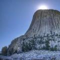
28. Having climbed to the very top, the road ended, I got out of the car to admire great view mountain valley. I was accompanied by a black domestic cat.
29. La Valle reminded me a lot of Dandelion Valley. Very a nice place, where you can stay away from the urban jungle, breathe in the clean mountain air and admire the fantastic mountain scenery.
30. I will not linger here, there is still a very rich program ahead. I made a few more stops and continued on my way. After driving another 15 kilometers, the road brought me to the banks of the Rienza River.
31. The next place I went to is the pearl of the Dolomites - Lake Lago di Braes. It is located at an altitude of almost 1500 meters above sea level. Everyone who plans a route through the Alpine corners of Italy should definitely visit here.
32. With difficulty finding a place in three equipped parking lots, I went for a walk along the shore of the emerald lake. People are brought here by buses, so here you don’t feel lost far away in the mountains. The path along the lake resembles the sidewalk of a decent city.
33. However, this in no way detracts from the beauty of Lago di Braes and does not cause discomfort. You can walk around the lake in about an hour, covering a distance of about 5 kilometers. It is a pity that the weather was overcast without a single hint of light.
34. Having taken a walk, I went to the car, but the nearby cafe beckoned me with fresh and fragrant pastries, I had to stay here for half an hour to have lunch and then visit another lake located nearby. Meet Lake Dobyacco (Toblach Sea).
35. In November, we got into a terrible snowfall here, but we looked at the beautiful swans, which from day to day were supposed to fly away towards the warm Adriatic.
36. Directly there is only 150 kilometers.
37. My route was built in a different way, but the tripod for the camera, forgotten in La Valle, made adjustments and the next place where I ended up was the Valparola pass and the lake of the same name. There is still snow on the pass even in July.
38. Having admired Lake Valparola from a height, I decided to get closer to its shore. As soon as I approached, I noticed some creature that was darting near the shore. It was hard to recognize him from afar. The “long” lens, reserved for such cases, helped me.
39. I read on the Internet that if you are very lucky, you can meet alpine marmots in the Dolomites. Turns out I got lucky. However, as soon as I tried to get closer to him, he immediately hid behind numerous stones. This photo is from a series of find a groundhog :)
40. Now I will tell you about another Dolomites lake. From the city of Bolzano there is a direct road to it, which begins with a three-kilometer tunnel. The lake itself is about 25 kilometers away. On the way, I make a stop in Welshnofen to take a closer look at an interesting chapel.
41. This lake is called Karretsa and it met me very cloudy and rainy in places. hopes for good weather there were almost none, so I had to be content with such obese views
42. Decided to go back and drink coffee in the parking lot. The miracle happened after some 15 minutes. The clouds suddenly receded and the sun finally illuminated the water surface of the lake.
43. This shot of the Lattemar Mountains in the reflection of Lake Carreza won second place in one of the National Geographic photo contests.
44. Having traveled enough through the Dolomites, I headed towards, probably, the most picturesque mountain range Tre Cime Di Lavaredo to meet the alpine sunset there. Having safely crossed the Tre Croki pass, I ended up near Lake Misurina. Standing on the banks of the Misurina with a cup of tea and hot apple strudel, bought in a store on the nearest street, admire the stunning view of the mountain lake.
45. Having traveled only a few kilometers up, I ended up on another lake called Antorno.
46. Carpets of colorful and fragrant alpine flowers and herbs surround almost all the shores of this fabulous lake. The weather is magnificent, in the late afternoon it finally cleared up.
47. At the risk of missing the last rays of the long-awaited sun, I climb up from Antorno. A barrier blocks my way. Having paid 20 euro rubles, I pass. Having wound 15 turns of the serpentine already familiar to me, I ended up somewhere in a rain cloud, and again +4 on the thermometer. Hostel Auronzo, located 100 meters from me, was barely visible. Hello, we have arrived! And where is the sun that shone in my face 10 minutes ago? Where is the sunset and the most important question: where, in fact, is the trident of Tre Cime di Lavaredo itself? Of course, I am not one of those people who lose heart, but I clearly wanted to see something else here. Leaving some things at the shelter, I went straight to the cloud to get my luck, hoping to see at least something ...
48. After walking half a kilometer, the cloud suddenly ended, and the majestic mountain peaks of Lavaredo hung over me. On the way, I came across such a beautiful chapel, which was built right on the edge of the abyss. The light area around it seemed very symbolic to me.
49. Stunning mountain scenery is everywhere, just have time to turn your head and press the camera buttons. Jumping over a small pass, I finally saw Tre Cime from the other side. I saw it exactly as I imagined it. Here is a sunset in the Alps.
50. However, the miracle did not last long, in this light I managed to take only a few shots, as the sun first disappeared behind the clouds, and then behind the neighboring mountain peaks. But thanks for that too. At the foot there are three small lakes "no name" with crystal clear glacial water.
51. Before dark, I had to get to the Auronzo shelter. The route "around Tre Cime" turned out to be about nine kilometers.
52. The next place I have to visit is the magnificent lake Federa, hidden in the mountains.
53. After Cortina, D'Ampezzo had to slow down and look for the right path. Fortunately, there was an information stand and signs near it. Leaving the car right on the side of the road, I began the six-kilometer ascent.
54. At first the track was relatively gentle and passed near a beautiful mountain gorge. Having crossed the bridge, I ran into a very steep mountain, which I had to climb. A test worthy of a good workout.
55. I have already seen a lot of things in the Dolomites, but Federa will be remembered for its unique and unlike landscapes and the atmosphere of Alpine tranquility.
56. I went down to the car much faster and headed towards the already mentioned Valparola pass. A little before reaching it, I left the car in the parking lot next to the deployed division of NATO troops and began a two-kilometer ascent to Lake Limides.
57. Along the way, I repeatedly met the fortifications of the First World War. Due to its accessibility, this route is very popular, especially among tourists with children.
58. Lake Limides is not very big - only 100 meters long. From all sides it is surrounded by magnificent mountain ranges. The springs gushing at the bottom of the lake create the illusion of heterogeneity and multicolored water.
59. Mountain Cinque Torri is within easy reach from here.
60. You can climb to its foot either on a lift or by car. Since the lift finishes work quite early, I drove up the mountain by car. A one-kilometer walk to the foot of the Cinque Torri, of course, was not difficult.
61. There is a museum of the First World War under open sky. Everywhere trenches, dugouts.
Dugouts have been reconstructed, soldier dummies and models of weapons of those times are on display.
62. The highest peak has a height of 2361 meters. About five years ago, this massif was partially destroyed - a huge boulder broke off from the second peak and fell. Climbers constantly train on the sheer cliffs of the Cinque.
This is the last part of my report. I planned to stay here until late in the evening, but the changeable wind again dragged numerous clouds from somewhere, it began to rain. Realizing that in this way the Dolomites told me “Goodbye!”, I got into the car and set off on a long journey to the Adriatic coast ...
6-05-2014, 14:31
Apennine mountains
- Apennine mountains
Mountain system in Italy, stretching for more than 1000 km from north to south of the country, mainly along the eastern coast of the Apennine Peninsula. The prevailing heights are 1200–1800 m, the maximum height of the mountain system is 2912 m (Corno Grande summit). The vegetation of the mountains is represented by Mediterranean shrubs, beech and coniferous forests, meadows are found on the peaks. Geologically, the Apennine Mountains are characterized by the predominance of erosion-dissected ridges. - Abruzzo Apennines
A high and wide mountainous elevation in the central part of the Apennines in Italy, between the Tronto and Sangro rivers. Also referred to as the Abruzzi. The Abruzzian Apennines consist of several mountain ranges composed mainly of Mesozoic limestones. - Amiata
Mountain of volcanic origin in Italy. It is located in the southern part of Tuscany, 50 km southeast of Siena, on the way between Florence and Rome. The height is 1738 m above sea level. Near Amiata are the Val d'Orcia, a UNESCO World Heritage Site. cultural heritage, and the upper Maremma. - Apuan Alps
Mountain range in Italy, in northern Tuscany. Part of the Apennine Mountains system. The Apuan Alps formed in the middle of the Triassic period, somewhat earlier than the rest of the Apennines. Widespread here karst forms relief, as well as marble rocks (the famous Carrara marble, which is considered one of the most valuable varieties in the world). The highest point of the ridge is the peak of Monte Pisanino (1946 m). - Gran Sasso
A mountain range in Abruzzo, the highest part of the Apennine mountains in general and the Abruzzi Apennines in particular. Includes three peaks of Corno Grande (2912 m), Corno Piccolo and Pizzo Intermesoli. In the canopy of Corno Grande is the southernmost glacier in Europe Calderone. The nature of the mountain range, unique for Central Italy, is protected by national park"Gran Sasso and Monti della Laga". - Calderone
Currently the southernmost glacier in Europe. Located in the square of the Corno Grande mountain, the highest point of the Apennines, in the Abruzzi region, in the Gran Sasso massif. After the disappearance in 1913 of the Corral de la Veleta glacier in the Sierra Nevada massif on the Iberian Peninsula, which lay at 37 ° north latitude, the Calderone glacier became the southernmost. Its size is decreasing every year due to melting, and, at current rates, it will disappear before 2020. - corno grande
Mountain in central Italy, the highest point of the Apennines. Mount Corno Grande is located in the Abruzzi region, in the Gran Sasso massif. Height - 2912 m. The top of Corno Grande is popular with climbers, there are several options for climbing, the first of which dates back to 1573. - Maella
Mountain range in Italy. The highest point is Mount Amaro (2793 m). Geologically, the massif belongs to the Central Apennines. Maella is administratively located in the Abruzzo region, in the provinces of Chieti, Pescara and L'Aquila. On the territory of the array organized the same name national park. - Monte Vettore
The highest mountain range mountain range Monti Sibillini. Part of the Monti Sibillini National Park. To the northeast of the mountain range is Lake Pilato. The mountain range is located in Italy, on the border of the Umbria and Marche regions. This massif is notable for the fact that in one of its valleys, located at an altitude of 1940 meters, according to local legends, there is a lake in which Pontius Pilate is buried. The main fame of this place is given by legends about various fairies and other heroes of legends who lived in the vicinity of this ridge. - Monte Meta
Mountain in Italy. Height - 2242 m. The mountain gave its name to the Monti della Meta mountain range, although it is not its highest point, yielding to Monte Petroso (2247 m). - Monte Pisanino
Mountain peak in Italy, Tuscany region. The highest point of the Apuan Alps (1946 m). The peak is administratively located on the territory of the commune of Minucciano (province of Lucca). According to legend, the mountain got its name from the Pisan soldiers who took refuge here. - Monti della Laga
Mountain range in Italy. The highest point is Monte Gorzano (2458 m). Geologically, it belongs to the Abruzzi Apennines. The length of the array is 24 km. Administratively, Monti della Laga belongs to three regions: Abruzzo, Marche and Lazio. Together with the neighboring massif of Gran Sasso, it forms the National Park "Gran Sasso and Monti della Laga". - Monti della Meta
Mountain range in Italy on the border of the regions of Abruzzo, Lazio and Molise. Geologically, the massif is part of the Apennine Mountains. The highest point is Monte Petroso (2247 m). Other peaks are Monte Meta (2242 m), Monte Cavallo (2039 m), Monte Mare (2020 m). In the array are the sources of the Sangro River, many mountain lakes. The area of the massif is 93.3 km². Beech prevails at altitudes of 900–1800 m. Mountain pine, black pine and drooping birch are also common. - Monti Sibillini
Mountain range in Italy central part Apennine is also their watershed. Since 1993, this range has been a national park. Mostly composed of limestone, formed at the bottom of an ancient sea. There are karst landforms. An important role in the formation of the relief was played by glaciers of the Quaternary period. The mountains themselves formed during the Mesozoic and Cenozoic era. There are many peaks over 2000 meters, the highest point is 2476 meters. - Northern Apennines
Mountain system in Italy, which is part of the Apennine mountains. The northern Apennines extend from the Colle di Cadibona (Bocchetta di Altare) pass in the north, separating the Apennines from the Alps, to the valleys of the Tiber and Metauro rivers, south of which the Central Apennines begin. - Tuscan-Roman Apennines
Mountain system in Italy, part of the Northern Apennines. The Tuscan-Roman Apennines are located on the territory of the historical regions of Tuscany, Romagna (with San Marino) and Montefeltro. In the northwest, the Passo della Futa separates them from the Tuscan-Emilian Apennines, in the south, behind the valleys of the Tiber and Metauro rivers, the Central Apennines begin, in the east, behind the Alpe della Luna mountains, the Umbrian-Markan Apennines are located. - Tuscan-Emilian Apennines
Mountain system in Italy, part of the Northern Apennines. The Tuscan-Emilian Apennines are located on the territory of the historical regions of Tuscany and Emilia. In the northwest, the Passo della Chisa separates them from the Ligurian Apennines, in the southeast, the Passo della Futa separates them from the Tuscan-Roman Apennines. the highest peak is Monte Cimone.
Mountain peaks
- Adamello
Mountain peak of the southern range of the Middle Alps. It is located within Italy, at the very Tyrolean border; height 3539 m; significant glacier. Adamello from the north side. The first ascent of Adamello was made by Julius Payer in 1864. - Breithorn
Mountain in the Pennine Alps, on the border of Switzerland and Italy, not far from the Matterhorn. Its height is 4164 meters above sea level. Breithorn has five peaks. - Gran Paradiso
Mountain of the Graian Alps located on the border of the Italian regions of Valle d'Aosta and Piedmont. The seventh highest mountain in the Graian Alps (the highest is Mont Blanc). This is the only mountain over 4000 meters high, located entirely on Italian territory. So it can rightfully be considered the highest peak in Italy. - Grand Joras
The peak in the Mont Blanc massif with a height of 4208 m is located on the border of Italy and France. The northern face of the summit of Grande Joras is one of the most difficult walls in the Alps. The summit consists of six peaks located in a ridge with a length of about one kilometer. - Zhela
Mountain peak on the border (department of the Alpes-Maritimes) and Italy (province of Cuneo), the highest point of the Mercantour massif in the Alpes-Maritimes. Height - 3143 m. - Liskamm
A mountain with a height of 4527 m, located in the Pennine Alps on the border between and Italy. Liskamm is a five-kilometer range with two distinct peaks. Due to the numerous overhanging boulders on the ridge and frequent avalanches, the mountain was nicknamed the cannibal. - Maddalena
A mountain in the Southern Limestone Alps, located northeast of Brescia in Lombardy. Due to its proximity to the city, it is called the "mountain of the Bresciani" (la montagna dei bresciani). Previously, the mountain was called Monte Denno (Monte Denno) from the Latin "Mons Domini". Height - 874 meters above sea level. On the slopes are located the communes of Nave and Botticino. Maddalena is part of the Brescia Hills Park. - Marguares
Mountain peak on the border of France (department of Alpes-Maritimes) and Italy (province of Cuneo), the highest point of the Ligurian Alps. Height - 2651 m. - Marmolada
Gora (east of Trento), the highest mountain in the Dolomites. This is part of the ridge that stretches from west to east. In the west, the mountain breaks into steep cliffs, forming a stone wall several kilometers long. To the north is a relatively gentle glacier. - Matterhorn
Mountain in the Alps. Located on the border between Switzerland and Italy. Height 4478 meters. The mountain rises between the Swiss resort of Zermatt and the Italian Breuil-Cervinia. The mountain's name comes from the German words Matte (meadow) and Horn (peak). - Mont Blanc
A crystalline massif, whose height reaches 4810 m. It is located in the Western Alps, which are part of mountain system Alps. Located on the border of France and Italy in the regions of Upper Savoie and Courmayeur. It is the highest point in Western Europe. The length is about 50 km. Glaciation area over 200 km², large glacier Mer de Glace. mountaineering center. - Monte Giovo
One of the highest mountain peaks in the Tuscan-Emilian Apennines, the height reaches up to 1991 m. It is located between the communes of Pievepelago and Barga, from the valley of the Serchio River. Accessible by two highways - CA / 527 or 525, also crosses the Apennine ridge. - Monte Lema
A 1621 m high mountain located in the Lepontine Alps. From Migliella, in the Lugano district, you can reach the top of Monte Lema in 10 minutes. At the top of the mountain are an observatory and a meteorological station. - Monte Leone
A mountain with a height of 3552 m, located on the border of Switzerland (Valais) and Italy (Piedmont). The highest point of the Lepontine Alps. It is located a few kilometers from the Simplon Pass. - Monte Prado
Mountain peak in the Northern Apennines in Italy. The height reaches 2054 m. The peak is located on the border of the provinces of Lucca and Reggio Emilia. It is part of the Appenino Tosco-Emiliano National Park. - Monte Rondinio
Mountain peak in the Tuscan-Emilian Apennines, the highest in the commune of Pievepelago, after the mountain peak of Monte Giovo. The height reaches up to 1964 m. - Monte Titano
The mountain in the Apennines, the highest point of San Marino, is composed of limestone. The mountain has three peaks, on each of which a tower is built - Guaita, Chesta and Montale, which are part of the complex of the Three Towers of San Marino. - Ortler
Mountain in the mountain range of the same name in Italy. Mount Ortler is the highest (3905 m.) point of the Italian region of Trentino - Alto Adige, and also, if we exclude the Bernina ridge, of all Eastern Alps. - Piz Boe
Mountain peak of the Sella massif in the Dolomites. Height 3152 meters. The highest peak of the Sella massif. It is located on the border of the provinces of Trento, Bolzano and Belluno in northern Italy. Located north of Mount Marmolada and east of the Sassolungo massif. Popular tourist site. - Punta Perruchetti
Mountain on the border of Italy and Switzerland. Height above sea level - 4020 m. This is the highest point of Lombardy and the second highest point of the canton of Graubünden and the Bernina mountain range. Despite the sufficient absolute height, the mountain is included only in the extended list of Alpine four-thousanders, since the relative height of Punta Perruchetti is relatively small. - Roccamelone
Mountain in the Alps, peak height 3538 meters above sea level. - Testa del Rutor
Mountain range in the Graian Alps in the Aosta Valley, Italy. The highest point is Ryutor Peak 3486 m. Mount Ryutor has one of the largest glaciers in the Western Alps. At a distance of about 25 km from Mount Ryutor lies the Mont Blanc massif. - schlern
Mountain in the Dolomites in northern Italy. The mountain is located in the west of the Dolomites, in South Tyrol. Located approximately 15 kilometers east of the city of Bolzano.
mountain ranges
- Graian Alps
Mountains, part of the Western Alps in France (Savoie), Italy (Piedmont and Valle d "Aosta) and Switzerland (west of the canton of Valais)[specify]. The highest peak of Western Europe, Mont Blanc (4807 m), is located in the Graian Alps. Alps Graiennes separated from the Cotes Alps (in the south) by the Mont Cenis Pass, from the Pennine Alps (in the northeast) by the Ferre Pass and the valley of the Dora Baltea River, from the Dauphine Alps (in the west) by the Arc River Valley. The Alps lie in the Savoy pre-Alpine massifs.The name of the Graian Alps comes from the name of the Celtic tribe of Graiotseli, who lived in the vicinity of the Mont Cenis pass and the Viou valley. - Western Alps
Part of the system of ridges and mountain ranges of the Alps to the west of the conditional line connecting Lake Constance and Lake Como (including passing along the upper reaches of the Rhine). The Western Alps stretch in the form of an arc convex in the north-west direction, about 500 km long and up to 130 km wide, and are divided into the Ligurian, Maritime, Provencal, Cote Alps, Dauphine Alps, Gray, Bernese, Pennine, Lepontine and Glarn Alps. In the Western Alps, a number of mountain ranges are also distinguished, including Vercors, Pelva and others. - Carnic Alps
Mountain range in the Southern Limestone Alps on the border between and Italy. They are located on the territory of East Tyrol, Carinthia and Friuli (province of Udine). They are divided by the Gail valley into the Carnic Alps proper and the Gailtal Alps. They got their name in honor of the Roman province - Carnia. The mountains, in turn, gave the name to the era of the geochronological scale - the Carnian age (the beginning of the late (upper) Triassic period). - Lepontine Alps
Mountains, part of the Western Alps in Switzerland (the cantons of Valais, Ticino and Grisons) and Italy (Piedmont). The Lepontine Alps are separated from the Bernese Alps (in the northwest) by the valley of the Rhone River, the Furka and St. Gotthard passes, from the Pennine Alps (in the southwest) by the Simplon Pass, from the Glarn Alps (in the north) by the Anterior Rhine Valley and the Oberalp Pass , from the Oberhalbstein ridge in the Eastern Alps - the Splügen Pass. The area to the west of St. Gotthard is also called the Ticinian Alps, to the east - Adoula. The highest point is Monte Leone (3552 m). - Pennine Alps
Mountains, part of the Western Alps in Switzerland (Canton of Valais) and Italy (Piedmont and Valle d "Aosta). The Pennine Alps are separated from the Graian Alps (in the southwest) - by the Ferret Pass and the valley of the Dora-Baltea River, from the Lepontine Alps ( in the east) - the Simplon Pass, from the Bernese Alps (in the north) - the valley of the Rhone River. The Pennine Alps include more than 40 peaks over 4000 m high. The highest point is Dufour Peak (4634 m). - Central Eastern Alps
A system of mountain ranges, part of the Alps in Austria, in eastern Switzerland, on the northern border of Italy and the northeastern border of Slovenia. Stretched from west to east from the Swiss canton of Graubünden to almost eastern border Austria. Are the most high part Eastern Alps. They lie between the Northern and Southern Limestone Alps. - Stubai Alps
Mountain range in the Central Eastern Alps. Located southwest of Innsbruck, Austria, the border with Italy passes through several peaks of the ridge. The highest point of the ridge is the Zuckerhütl, 3507 m. The ridge got its name from the Stubaital valley, which is located in the northeastern part of the Stubai Alps. - Ötztal Alps
Mountain range in the Central Eastern Alps. The highest point is Mount Wildspitze (3768 m), the second highest in Austria. The border between Austria and Italy runs along the massif - the northern and central parts are located on the territory of Austria, the southern part belongs to Italy. In the west, the ridge is bounded by the valleys of the Inn and Adige rivers and the Resia Pass connecting these valleys. - Julian Alps
A mountain range, a spur of the Alps, located in the Italian region of Friuli-Venezia Giulia, as well as in the Slovenian region of Carniola. The name of the mountains comes from Gaius Julius Caesar, who founded in the Friuli region and the western Extremely Roman province with the capital Cividale. In ancient times, the Julian Alps also covered the mountains further south. These included the Ternovsky forest located in the modern Ternovsky forest, as well as the Grushitsa plateau.
passes
- Great St. Bernard
A pass in the Alps through which, since the time of the Roman Empire, the main route has passed, connecting the North of Italy with central Europe. The height of the pass is 2469 m above sea level. - Brenner
Border pass in the Eastern Alps, located between the Austrian federal state of Tyrol and the Italian autonomous province of South Tyrol. - Little Saint Bernard
Pass in the Western Alps, on the border of France and Italy. It got its name in honor of Saint Bernard of Menton. The pass has long been of great importance for communication between the cities of Europe. Ancient cromlechs are still preserved on the pass, the construction of which dates back to the Neolithic. - Stelvio
The Stelvio Pass is located in Italy at an altitude of 2757 meters. The second largest pass in the Eastern Alps with an asphalt road. The first place is occupied by the Col de lIseran pass (2770 m) in France. - Theodule
Alpine pass between the Matterhorn and Breithorn peaks in the Pennine Alps, on the border of Switzerland and Italy. Its height is 3301 meters above sea level. - Umbrail
Alpine pass in the Alps on the border of Switzerland and Italy. Its height is 2501 meters above sea level. He connects settlements Santa Maria Val Mustair in the Val Mustair valley (Inn district, canton Graubünden, Switzerland) and Bormio in the Valtellina valley, (Lombardy region, Italy).
Mountains of Sicily
- Iblean mountains
Mountain range in southeastern Sicily. Located north of Ragusa and west of Syracuse in the provinces of Catania, Ragusa and Syracuse. - Madonie
Mountain range in the north of the island. The Madonie Mountains are located in the province of Palermo. The highest point is Pizzo Carbonara (1979 m), on the island second in height only to Etna. Two meters below the top of the Pizzo Antenna. Madonie together with the Nebrodi and Peloritani mountain ranges form the Sicilian Apennines. - Monte Archibesi
Peak on the island of Sicily. Height above sea level - 906 m, the third in the Iblean mountains. The mountain is located in the province of Ragusa between Ragusa in Chiaramonte Gulfi. Geologically, Monte Archibessi, with its surrounding mountains, is part of a Miocene extinct volcano. - Monte Casale
Pinnacle in Italy. It is located on the island of Sicily on the border of the provinces of Ragusa and Syracuse. The second highest peak in the Iblean Mountains. Height above sea level - 910 m. The climate on the slopes of Monte Casale is Mediterranean, but snowfalls are possible in winter. At the foot of the climate is milder. - Monte Lauro
Peak on the island of Sicily. Height above sea level - 987 m, this is the highest point of the Iblean mountains. The mountain is located on the border of the provinces of Ragusa and Syracuse, being the highest point of these provinces. - Monte Pellegrino
The cape, 609 meters high, is the second highest peak of the Palermo Mountains. Located in the province of Palermo. It is washed by the waters of the Tyrrhenian Sea, bordered in the north by the Gulf of Palermo, in the south by the Gulf of Mondello. Located in a protected area nature reserve Monte Pellegrino. The cape was a favorite vacation spot for travelers of the 18th-19th centuries and was called by Johann Wolfgang Goethe "the most beautiful cape in the world." - Monte Pizzuta
With a height of 1333 meters, the mountain is the highest peak of the Palermo Mountains, as well as the second highest peak in the west of Sicily. It is located in the commune of Piana degli Albanesi, in the province of Palermo. - Monte Soro
The highest point of the Nebrodi mountain range, located in the north of the island of Sicily, northwest of Etna. It is located on the territory of the Nebrodi National Park. Monte Soro is surrounded by beech groves. Near the mountain there are two small lakes at once: Lago Maulazzo and Lago Biverre. - Nebrodi
A mountain range in the north of the island of Sicily northwest of Etna. Nebrodi - mountains about 80 km long, composed of shales, sandstones, flysch, peaks - limestones. The highest point is Mount Soro or Monte Soro (1847 m). Together with the Madonie and Peloritani massifs, they form the Sicilian Apennines. - Palermo mountains
Mountain range on the island of Sicily, Italy. Together with Nebrodi, Peloritani, Madonie and the Trapani Mountains, they form the Sicilian Apennines mountain system. The name was given to the location from the city of Palermo, the capital of Sicily. The rivers Eleutherio and Yato, flowing into the Tyrrhenian Sea, are divided into two parts, eastern and western; in the south they pass into the hilly valley of Alta Valle del Belice. - Peloritani
Mountain range in the northeast of the island of Sicily. The Peloritani Mountains are located in the province of Messina. The highest point is Montagna Grande (1374 m), a large area of the massif is located at an altitude of 800–1000 m. The Peloritani, together with the Nebrodi and Madonie mountain ranges, form the Sicilian Apennines. - Pizzo Carbonara
The highest point in the Madonie mountain range and the second highest peak in Sicily, after Etna. Pizzo Carbonara is located 10 km northwest of Petralia Sottana. It is a limestone massif and all the rainwater from it eventually flows down to the city of Cefalu. - Rocca Busambra
With a height of 1613 meters, the mountain is the highest peak of the Sican Mountains, as well as the highest peak in the west of Sicily. Located in the commune of Godrano, in the province of Palermo. - Sican mountains
Mountain range in the south-central part of the island of Sicily, Italy. Located between the provinces of Agrigento and Palermo. The name was given by the name of the Sikan tribe, who inhabited Sicily in the Bronze Age. The name of the mountain range, in turn, gave the name to a vast area on the island, located between the cities of Palermo and Agrigento from north to south and the cities of Trapani and Caltanissetta from west to east. On the territory of the Sican Mountains, clay hills with mountain meadows alternate with peaks over 1000 m high. The highest peaks are Rocca Buzambra (1613 m) and Monte Cammarata (1578 m). - Sicilian Apennines
Mountain system in Sicily, located on the territory of the provinces of Messina and Palermo. The system is separated from the Southern Apennines by the Strait of Messina and stretches along Tyrrhenian coast islands. The Sicilian Apennines include the Madonie, Nebrodi and Peloritani mountain ranges, located between Palermo in the west and the Strait of Messina in the east. The system does not include the Etna volcano, as well as the Iblean and Ereisky mountains. The highest point is Mount Pizzo Carbonara (1979 m), according to altitude second only to Etna. - Erei mountains
Mountain range in the south-central part of the island of Sicily, Italy. It is located in the central and northern part of the province of Enna. The highest peak is Monte Altezina (1192 m). - Etna
An active stratovolcano located on east coast Sicily, near the cities of Messina and Catania. This is the highest active volcano in Europe. Now the height of Etna is 3329 m above sea level. It often changes from eruption to eruption. So, at present, the volcano is 21.6 m lower than it was in 1865. Etna is the highest mountain in Italy south of the Alps, it covers an area of 1250 square kilometers. Thus, Etna is the largest active volcano Italy, surpassing its closest "rival" Vesuvius by more than 2.5 times.
The mountains
- Alban mountains
Mountain range in Italy. The Alban Mountains are the remnants of a mountain ring formation of volcanic origin. Their length is about 60 kilometers in the region of Lazio, the province of Rome, 20 kilometers southeast of Rome and 24 kilometers north of Anzio. The highest point is Monte Cavo, 950 meters high. In its southwest, the circular mountainous landscape is torn apart by 2 crater lakes - Albansky and Nemi. - Alps
The highest mountain system in Western Europe. They represent a complex system of ridges and massifs, stretching in a convex arc to the northwest from the Ligurian Sea to the Middle Danube Plain. Capture the territories of 8 countries: France, Italy, Switzerland, Austria, Liechtenstein, Slovenia. The total length of the Alpine arc is about 1,200 km (about 750 km along the inner edge of the arc). Width up to 260 km. The highest point is Mont Blanc, 4808 meters. The eastern spurs of the Alps - the Leith Mountains and the western spurs of the Carpathians - Hundsheimer Berge are only 14 km away. Alps - international center mountaineering, skiing and tourism. - Argentera
Mountain range and peak of the same name in the Alpes-Maritimes, in Italy (province of Cuneo). Height - up to 3297 m. - Barbagia
Mountainous region in the interior of Sardinia. In terms of territory, it almost completely coincides with the province of Nuoro and is located along the Gennargentu mountain range. - Bernina
A mountain range in eastern Switzerland and northern Italy between the headwaters of the Inn and Adda rivers, part of the Central Eastern Alps. The highest point is the peak of the same name (4049 m), this is the easternmost part of the Alps, where the peaks exceed 4000 m above sea level. Geologically, the massif, like all the Eastern Alps, is composed of gneiss and shales. - Vesuvius
An active volcano in southern Italy, about 15 km from Naples. Located on the coast Gulf of Naples in the province of Naples, Campania region. Included in the Apennine mountain system, has a height of 1281 m. - Dolomites
Mountain range in the Eastern Alps, part of the system of the Southern Limestone Alps. The massif is located in the northeastern part of Italy in the provinces of Belluno, Bolzano-Bozen - South Tyrol and Trento. - Kanin
Mountain range in the Julian Alps, on the border of Slovenia and Italy. The highest of the peaks of the massif reaches a height of 2587 m. - Colleto Fava
One and a half kilometer hill in northern Piedmont (Italy). In 2005, members of the Viennese art group Gelitin completed a huge pink plush rabbit on a hillside. The work is about 60 m long and 6 m high. Members of the art group expect, among other things, that climbers will climb this work for recreation. - Kotian Alps
Mountains, part of the Western Alps in France and Italy. The Cotes Alps are separated from the Alpes-Maritimes (in the south) by the Larsh (Maddalena) Pass, from the Graian Alps (in the north) by the Mont Cenis Pass, from the Dauphine Alps (in the west) by the Galibier Pass. - Ligurian Alps
Mountains, part of the Alps within the Italian region of Liguria, framing the Ligurian Sea. Often considered as part of the Alpes-Maritimes. - Lombard Alps
The collective name of the mountain ranges and massifs of the Alps, located mainly within the administrative region of Lombardy in Italy. - Monte Disgracia
The main peak of the Bergel Alps, one of the most significant mountains in the Eastern Alps. - Ortler
Mountain range in eastern Switzerland and northern Italy, part of the Southern Limestone Alps, located south of the Central Eastern Alps. The highest point of the massif is Mount Ortler, the top of which is located at an altitude of 3905 m above sea level. - Rhaetian Alps
The central part of the Eastern Alps in Italy, Switzerland and Austria, between the Splügen and Resia passes. - Sella
Mountain range in the Dolomites in northern Italy. Located north of Mount Marmolada and east of the Sassolungo massif. Surrounded by four valleys: Badia, Val Gardena, Val di Fassa and Fodom. The Sella massif is divided between three provinces: Bolzano, Trento and Belluno. The highest point of the massif is Piz Boe peak (3151 m). - Power
A mountain plateau located in southern Italy in the central part of the Calabria region. It occupies an area of more than 2000 sq. km. The average height of the plateau is 1300 m, and by themselves high points Sila are the peaks of Botte Donato (1928 m.), located in Sila Grande, and Gariglione (1764 m.) in Sila Piccola. - Tofana
Mountain peak in the Dolomites west of Cortina d'Ampezzo. Located in the Veneto region, province of Belluno, northern Italy. The maximum height is 3243 m. - Southern Limestone Alps
Mountain range, part of the Alps in northeastern Italy, on southern border Austria and the northwestern border of Slovenia. Stretched from west to east south of the Central Eastern Alps.
In Italy, the summer period is coming, which means it's time to choose a place for your future vacation! And where and how do the locals relax? Let's get a look!
Every summer, the Italians are divided into 2 “fronts”: the “sea team” and the “mountain team”. Half prefer a beach holiday under the hot summer sun, and the other half - escapes from the stuffiness of big cities in the mountains. And the higher the better!
Where to go?
Sea in Italy
Without a doubt, the Italians are very fond of beach holiday it is in your own country, in Italy, that you can immediately go to 4 seas, because it is surrounded by the Ligurian, Ionian, Tyrrhenian and Adriatic.
Such a huge marine diversity in just one country: choose what you want!
In addition to choosing which sea to go to in Italy, you also need to decide on the type of vacation: mainland and island. So, if you want to stay in the main territory of Italy, then go to the following regions:
- Calabria region (for example, in Tropea),
- Liguria region (for example, Alassio or San Remo)
- the region of Emilia-Romagna (to the mecca of the Italian beaches of Rimini).
If you prefer to visit the islands of Italy, then give preference to Sardinia, Sicily or Capri: there you will find incredible beautiful nature and excellent conditions for summer holidays.
By the way: during your vacation you may need a car to see the entire coast and nearby towns, you can rent a car in Italy through this site.
Mountains in Italy
In addition to the 4 seas, the mountains in Italy are also popular for recreation: the Apennines are stretched along the length of the “boot”, and the Alps are stretched from above. So if you want to enjoy outdoor activities and reunite with nature, you can go to the Emilia-Romagna region with its famous Carno alle Scalle (province of Bologna), to the Dolomites in the Trentino Alto Adige region (for example, to the mountain town of Andalo) or to the famous Cortina. All these and others mountain regions Italy is available for summer holidays and will give you many ideas for entertainment!
Interesting fact: if in winter a huge part of the southern inhabitants of Italy moves north to ski and snowboard in the Alps, then in summer the opposite is true: the north of Italy "migrates" to its south, as in major cities northern part of Italy in summer is very stuffy, humid and hot.

Things to do?
Sea
What to do on the beach? Relax, have fun, swim, sunbathe, enjoy the incredible beauty of the sea and spend great time with friends and family!
Interesting fact: Quite a lot of Italians don't really like to swim, but prefer to just go knee-deep into the water and chat with each other about everything in the world. At least all day long! Very few people really actively swim for half an hour or more (as our compatriots often do with pleasure), and in order to freshen up a little, they quickly get into the water, rinse and continue to stand under the sun :)

The mountains
In the summer in the mountains you can find entertainment for every taste: climbing, relaxing on lakes, hiking, especially in the mountains of Italy, trekking trips are popular. You also have the opportunity to go skiing. Yes, yes, even in the midst of the hot season, you can go to the glaciers where skiing and snowboarding is available all year round! Italy's glaciers are located in the Stelvio and Senales.

Where to go next to Italy?
Sea
Let the Italians love their summer holidays at home, but sometimes they are happy to visit other countries. For trips from Italy to the sea, frequent destinations are Spain, Greece and the Côte d'Azur.

The mountains
Even taking into account the fact that both the Apennines and the Alps are located in Italy, but sometimes for the sake of diversity, local residents go for mountain holidays and to the "Holy Trinity": Austria, Switzerland or France. but mountain vacation in these countries will cost more than in Italy.

What type of summer vacation do you prefer: sea or mountain? Or maybe even combine?
Leave your comments and stay with us: site - this is the most interesting thing about the life of Italy!