


 Back forward
Attention! Slide previews are for informational purposes only and may not represent all the presentation options. If you are interested in this work, please download the full version.
Goals and objectives of the lesson: to form an image of the studied territory; to expand and deepen the knowledge of students about the peculiarities of the geographical location, origin and structure of the territory of Western Siberia, to form ideas about the relief, climate, inland waters and natural zones; form basic terms and concepts; to continue the formation of skills to work with various sources of geographical information, to determine the peculiarities of the geographical location of the territory and to establish relationships between the components of nature, to develop the emotional sphere of students, to form students' respect for nature through the study of the unique natural complex of Western Siberia.
Educational-visual complex and equipment: physical map of Western Siberia, tectonic, climatic maps of Russia, computer, projector, screen, textbooks, atlases, electronic presentation.
Terms and concepts: young platform, plate, lowland, ridges, depressions, saucers, glaciation, polar night, swamp, oxbow, meanders, closed lake, thermokarst, polygonal relief, latitudinal zoning, manes, pegs, urmans.
Geographic objects
Karskoe ;
DURING THE CLASSES
1. Organizational moment.
2. Updating knowledge (slides 1-2). The teacher invites students to consider the panorama of Western Siberia, formulates, together with the students, the topic, goals and objectives of the lesson.
Demonstration of the Vasyugan Plain (a section of Western Siberia located between the Ob and Irtysh rivers), accompanying the reading of an excerpt from travel sketches about a trip to Sakhalin Island: from the Urals up to the Yenisei itself. A cold plain, crooked birches, puddles, here and there lakes, snow in May, and desolate, dull banks of the Ob tributaries — that's all that memory can be preserved from the first two thousand miles ”.
The teacher invites the students to give their opinion and come back to this question at the end of the lesson.
3. Learning new material.
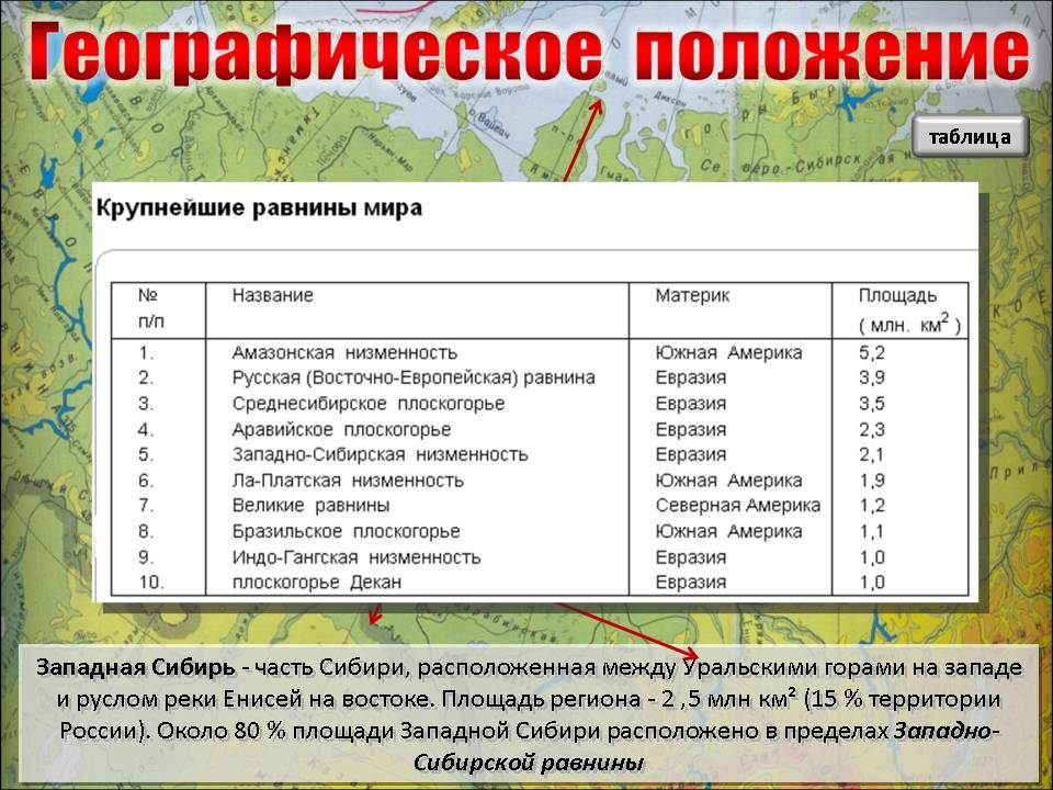
3.1. Geographical position (slide 3). Search conversation (frontal work). Students answer questions using physical map in the atlas, they note the peculiarities of the position of Western Siberia on the territory of Russia, the area, shape, boundaries and length of the territory.
Western Siberia is a part of Siberia located between the Ural Mountains in the west and the channel of the Yenisei River in the east. The area of the region is 2.5 million km? (15% of the territory of Russia). The territory in the plan has the shape of a trapezoid, stretching from north to south for 2500 km from the Arctic Ocean to the hills Kazakh Upland, 800 and 1900 km from the Ural mountains to the Yenisei. In the north it is washed by the Kara Sea and crossed by the Arctic Circle. In the south, Western Siberia borders on Kazakhstan along the state border (they find on the map the Yamal, Gydansky peninsulas, Obskaya Bay, Baidaratskaya Bay, Gydanskaya Bay). About 80% of the area of Western Siberia is located within West Siberian Plain(determine the place of the plain in the world by the area of the territory).
What are the implications of geographic location study area?
The teacher demonstrates the landscapes of Western Siberia (slides 4-11, slide 4- the menu, hyperlinks, the "rounded rectangle" shape is configured, return to slide 4 is carried out by clicking on the "arrow" shape).
The study of the components of nature relies on menu - slide 12.
3.2. Relief, tectonic structure, geological development and minerals (slides 13-17).
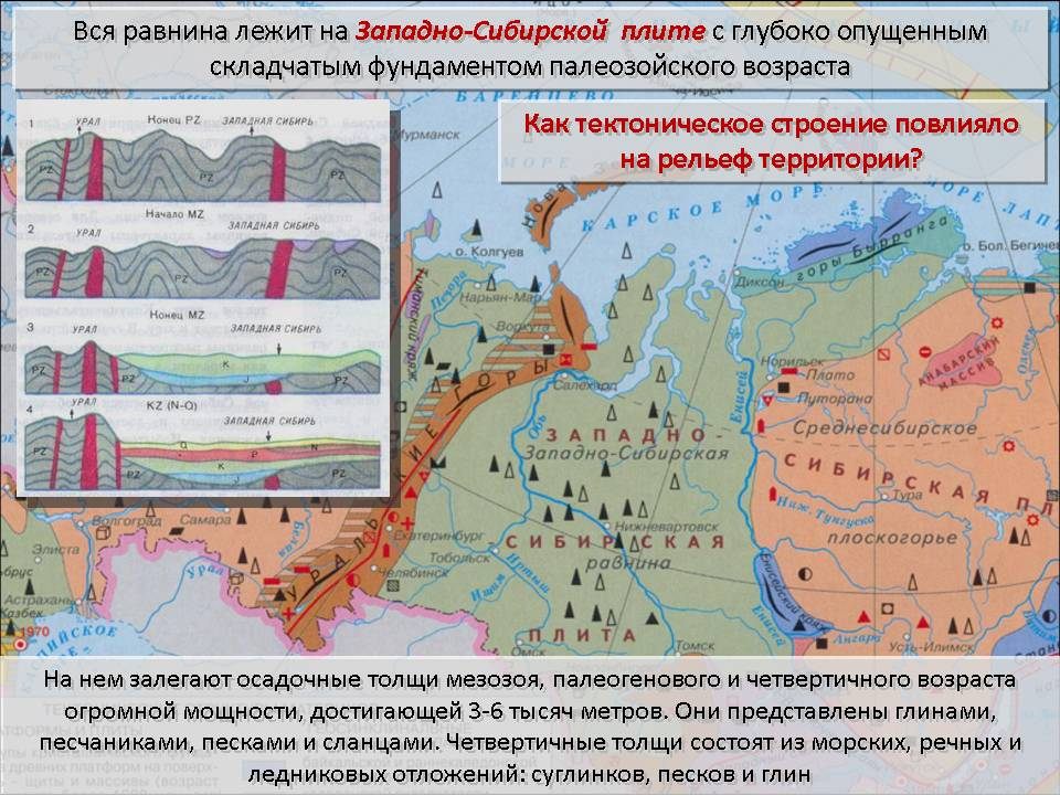
Slide 13. Many features of the nature of Western Siberia are due to the nature of its tectonic and geological structure, the history of development. The whole plain lies on West Siberian plate with a deeply lowered folded basement of the Paleozoic age.
It is overlain by sedimentary strata of the Mesozoic and Cenozoic (Paleogene and Quaternary) age, the thickness of which exceeds 1000 meters, and in some places reaches 3-6 thousand meters. They are represented by clays, sandstones, sands and shales. Quaternary strata consist of sea, river and glacial deposits: loams, sands and clays.
The northern half of the plain has repeatedly been the scene of sea transgressions and glaciers. In the south of Western Siberia at this time, there was an accumulation of lacustrine and river sediments.
How did the structure affect the relief of the territory?
Slide 14. A thick horizontally lying sedimentary rock stratum leads to flatness of the modern relief. The northern and central parts of Western Siberia are lowlands located at an altitude of up to 100 m above sea level. In general, Western Siberia has the shape of a huge bowl, rising slightly to the west, south and east and tilting to the north. The main elements of the relief of the plain are wide flat interfluves and river valleys.
What plains are there in Western Siberia? (found on the map: Sredne-Obskaya, Ishimskaya, Barabinskaya, Kulundinskaya, Vasyuganskaya, Nadymskaya).
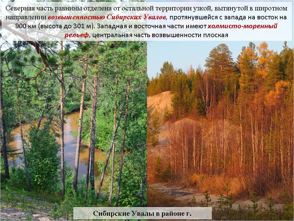
Slide 15. The northern part of the plain is separated from the rest of the territory by a narrow, elongated latitudinal upland of Siberian Uvaly, stretching from west to east for 900 km (height up to 301 m). The western and eastern parts have hilly moraine relief, central part the hills are flat and very swampy
Slide 16. The structure of the territory determined the composition of the region's mineral resources. They are mainly of sedimentary origin.
What minerals are mined in Western Siberia? (oil, natural gas, coal, cooking (rock) and Glauber's salts)
Where are the largest oil and gas fields located? (Yamal, Middle Ob)
Slide 17. During the revival of the Ural and Altai mountains, loose sedimentary strata of the West Siberian plate were deformed. They formed underground domes composed of sands covered with dense clays. There was an accumulation of oil and gas. The largest oil fields are in the Surgut region, gas - in the Urengoy region and on the Yamal peninsula.
3.3. Climate (slides 18-21).
Slide 18. The inland position of Western Siberia determined the severity and continentality of its climate, especially in the south of the plain.
The flatness of the territory and its great length from north to south determine a clearly expressed climate zoning and significant differences climatic conditions northern and southern parts Western Siberia (called the arctic, subarctic and temperate climatic zones). They are associated with a change in the quantity total solar radiation and character circulation air masses. The formation of the climate is influenced by kAV, kVUSh, especially western transfer ( mVUSH). In the second half of winter, an area of increased atmospheric pressure extends to Western Siberia (Asian high)
Questions on the tables for the points Kharasavey, Surgut, Omsk: What are the temperatures during the winter period? (persistent low) Summer? (July temperature increases from north to south). What is the increase in climate continentality from northwest to southeast manifested? annual amplitude fluctuations in air temperature, a decrease in precipitation).
Slide 19. The high-latitude location of Yamal, a small influx of solar radiation, a considerable distance from the warm air and water masses of the Atlantic and Pacific oceans, flat relief, open for the invasion of air masses from the Arctic into summer time and hypothermic continental masses in winter, determine the severity of the climate (they call the arctic climate type). It is characterized by a short cold summer, winter lasts 8 months, often blizzard, observed for several weeks polar night.
Kharasavey - a rotational village in the Yamalo-Nenets Autonomous Okrug Russian Federation... Located on the western coast of the Yamal Peninsula, it got its name from Cape Kharasavey.
Slide 20. Salekhard (from the Nenets “settlement on a cape”) - the administrative center of the Yamalo-Nenets Autonomous Okrug. The only city on earth located directly at the latitude of the Arctic Circle. Located in the subarctic climatic zone. There are also short cool summers, long winters, strong winds. ... Polar day in Salekhard there is a month (from June 7 to July 7): 31 days a year, the upper edge of the sun does not descend under the horizon. Twilight nights, when the sun does not drop below -18 degrees, last from April 4 to September 9, 159 days a year. There is no polar night in the city.
Slide 21 Omsk is located in the continental climate... Winter is harsh, frosts are up to 35-40 degrees, the weather is clear. Snow melts in 10-12 days. In summer, on clear, sunny days, the air temperature rises to 30-35 degrees. In the first half of summer, dry winds are not uncommon (strong sultry winds, scorching plants and causing a strong drying out of the soil). On average, 300-350 mm of precipitation falls here a year, which is 1.5-2 times less than in central regions Russia.
3.4. Inland waters (slides 22-29).
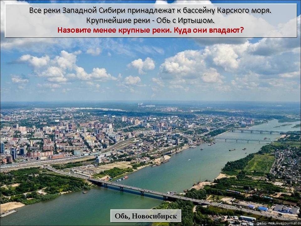
Slide 22. All rivers of Western Siberia belong to basin of the Kara Sea. The largest rivers are the Ob and the Irtysh.
Name the smaller rivers. Where do they flow? (called: Pur, Taz - the Kara Sea; Irysh, Vakh, Ket, Chulym, Tom, Vasyugan, Sosva - tributaries of the Ob; Ishim, Tobol, Konda - tributaries of the Irtysh; Tura, Iset - tributaries of the Tobol)
Slide 23.The largest waterway - the Ob with the Irtysh tributary - is one of the greatest rivers the globe.
It originates in Altai at the confluence of two rivers Biya and Katun. Locals the confluence point of dissimilar rivers (“Biy” and “Khatyn”) has long been revered as a sacred place.
Its basin area is almost 3 million km 2. The length from the sources of the Irtysh is 5410 km. If we consider the length of the Ob from the source of the Katun, then it reaches 4345 km, and from the confluence of the Biya and Katun - 3650. This is one of the most abundant rivers in Siberia; she brings an average of 414 to the Gulf of Ob per year km 3 water. In terms of water content, the Ob occupies the third place in Russia, yielding only to the Yenisei and Lena.
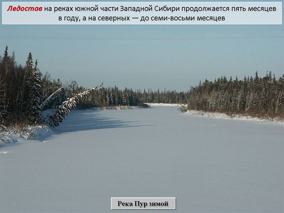
Slide 24. Freezing up on the rivers of the southern part of Western Siberia lasts five months a year, and on the northern - up to seven or eight months.
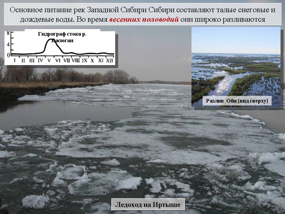
Slide 25. The main feeding of the rivers of Western Siberia Siberia is melted snow and rainwater. During spring floods they spread widely. Work with the gtdrograph of the Vasyugan river flow.
In accordance with the nature of power sources, the runoff is uneven by seasons: approximately 70-80% of its annual amount occurs in spring and summer. Especially a lot of water flows down during the spring flood, when the level of large rivers rises by 7-12 m.In the winter months, no more than 10% annual flow (low water).
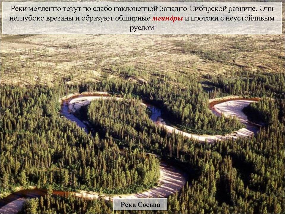
Slide 26. Rivers flow slowly over the slightly inclined West Siberian Plain. They are shallowly cut and form extensive meanders and channels with an unstable bed. Even the largest rivers are characterized by slight slopes and low flow rates.
Because of the small slopes of the channel, lateral erosion prevailed in most of the river valleys of Western Siberia, the deepening of the valleys was slow, and therefore they are usually of considerable width, but shallow depth.
Slide 27. Flat surface of the northern half of the territory, poor drainage associated with shallow incisions of rivers, excessive moisture, abundance groundwater coming from the elevated edges of the plain, all of which led to the formation of vast marshes. Western Siberia is the most swampy plain in the world.
Slide 28. There are about one million lakes within the plain, the total area of which is more than 100 thousand km 2. By origin hollows several groups can be distinguished: occupying primary irregularities flat relief, thermokarst, floodplain, old, moraine-glacial... In the wide valleys of the Ural part of the plain, there are lakes - "fogs" which flood in spring, sharply reduce their size in summer, and in autumn many disappear altogether. In the forest-steppe and steppe regions of Western Siberia, there are lakes that fill suffusion hollows.
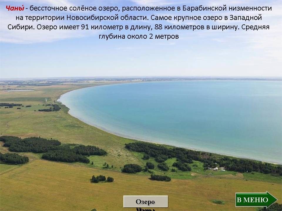
Slide 29. There are many drainless brackish and salty lakes. Chanym- an internal drainage salt lake located in the Barabinskaya lowland on the territory of the Novosibirsk region. The largest lake in Western Siberia. The lake is 91 kilometers long and 88 kilometers wide. The average depth is about 2 meters.
3.5. Natural areas (slides 30-39).
Slide 30: The flat relief of Western Siberia contributes to a pronounced zoning in the distribution of soils and vegetation cover. There are tundra, forest-tundra, forest-swamp, forest-steppe and steppe zones gradually replacing one another.
Slide 31. The tundra zone occupies the Yamal, Tazovsky and Gydansky peninsulas. It stretches much farther north than on the Russian Plain. An important role is played by lichen and moss tundras, which are found in combination with lichen-sphagnum, as well as large-hilly bog massifs.
The harsh climate of the northern regions of Western Siberia, where the heat entering the soil is not enough to maintain a positive temperature of rocks, contributes to the freezing of soils and widespread permafrost... On the Yamal, Tazovsky and Gydansky peninsulas, permafrost is found everywhere. In these areas of its continuous (continuous) distribution, the thickness of the frozen layer is very significant (up to 300-600 m), and its temperatures are low (-2, -8 °). To the south, within the northern taiga up to latitude of about 64 °, permafrost occurs already in the form of isolated islands, interspersed with taliks. Its power decreases, temperatures rise to 0.5-1 ° C.
Slide 32. Thermokamrst- the process of uneven subsidence of soils and underlying rocks due to thawing of underground ice and subsidence earth surface formed during thawing of frozen soils. The result is polygonal relief.
Slide 33. The forest-tundra descends to the south in a strip of about 100-150 km almost to the Siberian Uvaly. It presents larch and birch crooked forest... In the south of the forest-tundra, pine and cedar appear in the forests. Along the rivers, sparse Siberian larch forests go far to the north, since the river valleys are drier because of better drainage, and heat comes from the south with river water. In areas lying to the west of the Urals, such forests are represented by spruce.
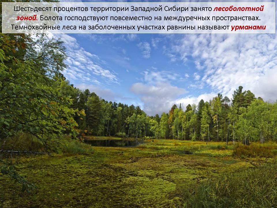
Slide 34. Forest (taiga, forest-swamp) zone covers the area between 66 o and 56 o N. a strip of about 1000 km, occupying about 60% of the territory of Western Siberia. The main type of forests in the zone are dark coniferous forests with a predominance of spruce and fir and Siberian pine. The most important element of taiga landscapes is swamps lowland and riding type. The middle and northern parts of the West Siberian Plain are among the most waterlogged areas on the earth's surface. Pine forests are most often confined to the sandy deposits of the plains. In addition, within the forest zone, pine is a characteristic tree of sphagnum bogs and forms a kind of association of sphagnum pine forests on boggy soils. Broad-leaved species (with the exception of linden, which is rarely found in the southern regions) are absent in the forests of Western Siberia. The dark coniferous forest in the wetlands of the plains is called urman.
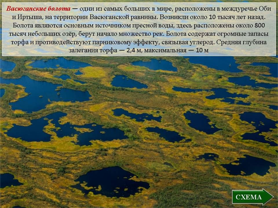
Slide 35 The Vasyugan bogs are one of the largest in the world, located between the Ob and Irtysh rivers. Area - 53 thousand km? They appeared about 10 thousand years ago and have been constantly increasing since then. Swamps are the main source of fresh water in the region, there are about 800 thousand small lakes, many rivers originate. Swamps contain huge reserves of peat and counteract the greenhouse effect by sequestering carbon. Average depth of peat occurrence - 2.4 m, maximum - 10 m
Slide 36. Taiga forests grow mainly on the slopes of river valleys and narrow sandy rises in the interfluves - manes... In the western pre-Ural part of the zone, dominated by pine forests... In the northern and middle parts of the plain, spruce - cedar and larch forests dominate, in the southern - taiga of spruce, cedar, fir, birch.
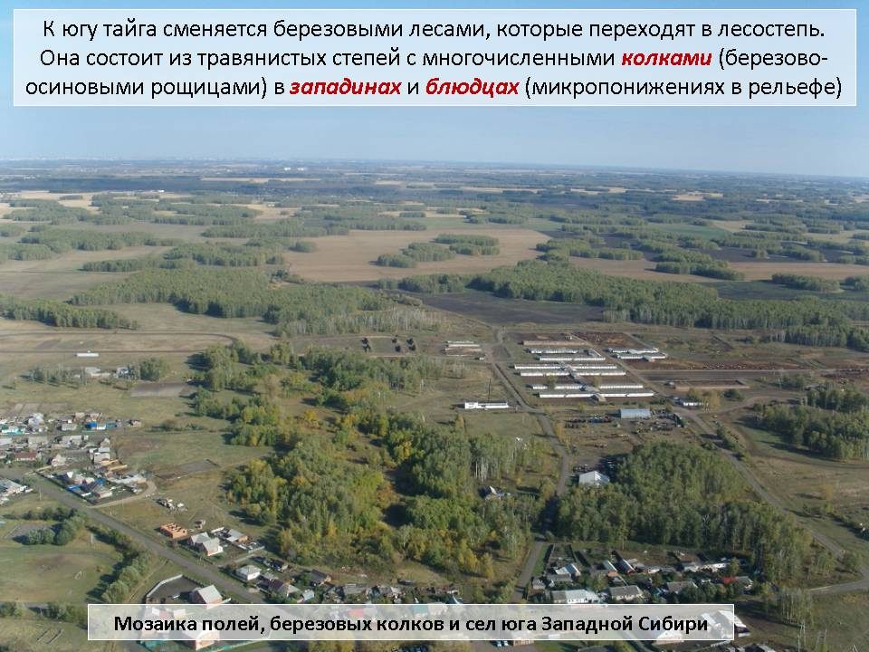
Slide 37. To the south, the taiga is replaced by birch forests, which turn into forest-steppe... It consists of grassy steppes with numerous with pegs(birch-aspen groves) in depressions and saucers(microdepressions in the relief).
Slide 38. The extreme south of Western Siberia is occupied by the steppe zone, where obese chernozems and dark chestnut soils. They are almost completely plowed up. Spring wheat fields are located on vast tracts of former virgin lands
Slide 39. In the steppes there are many salty drainless lakes where soda and table salt are mined.
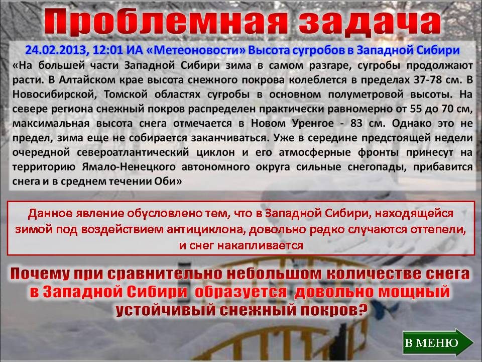
4. Solving the problem problem in groups (slide 40). The teacher reads out the text message News Agency "Meteonovosti" from 02.24.2013 (12:01): “In most of Western Siberia, winter is in full swing, and the snowdrifts continue to grow. In the Altai Territory, the height of the snow cover ranges from 37-78 cm. In the Novosibirsk and Tomsk regions, the snowdrifts are mostly half a meter high. In the north of the region, the snow cover is distributed almost evenly from 55 to 70 cm, the maximum snow height is observed in Novy Urengoy - 83 cm. However, this is not the limit, winter is not going to end yet. Already in the middle of the coming week, the next North Atlantic cyclone and its atmospheric fronts will bring heavy snowfalls to the territory of the Yamalo-Nenets Autonomous Okrug, and snow will also increase in the middle reaches of the Ob.... Question: Why, with a relatively small amount of snow in Western Siberia, is a rather thick, stable snow cover formed?
Students discuss options, voice them and give reasoning for answers.
Answer: This phenomenon is due to the fact that thaws rarely occur in Western Siberia, which is under the influence of an anticyclone in winter, and snow accumulates.
5. Summing up. Reflection.
Students answer the questions: What new have we learned in lesson today? What new concepts did you meet? What did you like? What caused the difficulty? Who was the most active in the class? and etc.
6. Homework: paragraph 38, questions, cartographic nomenclature, preparation by groups of messages about the reserves of Western Siberia, environmental problems and areas of human economic activity.
the date of the ___________________________
Option 1
Part 1
Indicate what does not apply to inland waters
Rivers and lakes
Lakes and swamps
Seas and bays
Glaciers and permafrost
In which mountains is the source of the Ob River?
Caucasus
Altai
Sayan
Ural
Choose the most swampy plain in Russia
Meshcherskaya lowland
West Siberian Plain
North Siberian lowland
Caspian lowland
Indicate which group of rivers belong to the Arctic Ocean basin
Neva, Don, Dnieper, Kuban
Kolyma, Ob, Yenisei, Lena
Neva, Pechora, Amur, Volga
Which statement about Russia's water resources is correct?
Russia's water resources are unevenly distributed
Water resources of Russia depend on geographic latitude
Russia's water resources are concentrated in the European part
Russia's water resources do not affect the development of agriculture
The excess of the source over the mouth is:
river slope
river fall
river size
river height
What is the name of a sudden rise in the water level in the river?
High water
Flood
Flooding
Flood
The main reason for the formation of permafrost
crustal movement
harsh climate
development of the north by people
accumulation of water in the ground
In Russia, the largest number of mountain glaciers is concentrated on ...
northern Urals
Koryak highlands
Altai
Caucasus
Rain food is predominant for rivers ...
European part
Western Siberia
Eastern Siberia
south of the Far East
Establish a correspondence between rivers and their tributaries
Rivers tributaries
A) Cupid 1) Biya and Katun
B) Ob 2) Shilka and Argun
C) Volga 3) Vilyui and Aldan
D) Lena 4) Oka and Kama
12. Set the correspondence:
Ocean pool River
A) Quiet 1) Yenisei
B) Arctic 2) Cupid
C) Atlantic 3) Don
4) Lena
5) Volga
6) Neva
13. Set the correspondence:
The origin of the basin Lakes
A) Baikal 1) Tectonic
B) Kronotskoe 2) Glacial-tectonic
C) Onega 3) Volcanic
Part 2.
Indicate the main reasons for the spread of swamps.
What lake are we talking about?
The lake is located in the eastern part of Russia. Has a hollow tectonic origin... The Angara River originates in this lake. The depth is 1620 meters.
Surname, name ______________________________________________
the date of the ___________________________
Option 2
Part 1
Most of the rivers in Russia are fed:
Rain
Glacial
Snow
Mixed
In which mountains is the source of the Yenisei River?
Caucasus
Sayan
Altai
Ural
From the suggested plains, select the swampy
Valdai
Meshcherskaya
Privolzhskaya
Central Russian
Indicate which group of rivers belongs to the Atlantic Ocean basin
Neva, Don, Dnieper, Kuban
Kolyma, Ob, Yenisei, Lena
Amur, Kamchatka, Anadyr, Penzhina
Neva, Pechora, Amur, Volga
Which statement about lakes is wrong?
A large number of lakes in Karelia and Kola Peninsula educated
in hollows plowed up and worked by a glacier
Half of Russia's fresh waters are concentrated in Lake Baikal
The distribution of lakes across the territory of Russia is uneven
Lake Baskunchak fresh
What is the name of the lowest water level in a river?
High water
Flood
Low water
Flood
The amount of water that the river carries out in a year is called ...
solid drain
water consumption
river regime
annual flow
The permafrost zone includes
Russian and West Siberian plains
West Siberian and North Siberian lowlands
North of the Russian Plain, most of Western Siberia, almost all Eastern Siberia and the Far East
Eastern Siberia and the Far East
Most often, avalanches are observed at ...
Ural
Caucasus
Altai
Putorana plateau
The feeding of the rivers of the Caucasus and Altai is mainly
Rain
Snow and rain
Snow
Glacial and snow
Establish a correspondence between the types of glaciers and the territories of their distribution
Types of glaciers Place of distribution
A) cover glaciers 1) Caucasus
B) mountain glaciers 2) New earth
3) Altai
4) Northern Land
12. Set correspondence:
Ocean pool River
A) Arctic 1) Ob
B) Quiet 2) Cupid
C) Atlantic 3) Neva
4) Pechora
13. Set the correspondence:
The origin of the basin Lake view
A) Tectonic1) The length of the basin is much greater than
B) Glacial width
B) Volcanic2) Crescent-shaped depression
D) Old women 3) The rounded shape of the basin
4) Insignificant depth, rugged shape
hollows
5) Steep, steep banks, large
depths
Part 2.
What rivers are flooded more often? Why?
What lake are we talking about?
The lake is located in the western part of Russia. It has a glacial-tectonic basin. The Neva River originates in this lake.
Answers: Option 1 Part 1
1-3
2-2
3-2
4-2
5-1
6-2
7-4
8-2
9-4
10-4
11- A-2 B-1 B-4 D-3
12- A-2 B-1.4 B-3.6
13- A-1 B-3 B-2
Part 2
1- Flat relief, moisture coefficient is more than 1, permafrost, close occurrence of groundwater
2- Baikal
Option 1 Part 1
1-4
2-2
3-2
4-1
5-4
6-3
7-4
8-3
9-2
10-4
11- A -2.4 B-1.3
12- A-1.4 B-2 B-3.5
13- A-1.5 B-4 C-3 D-2
Part 2
On the rivers of the northern runoff. In the spring, in the upper reaches of the rivers located to the south of the lower reaches, there is already ice drift and floods, and in the lower reaches the ice has not left yet. As a result, ice jams and dams are formed, above which the water level rises, and the river overflows its banks.
Ladoga lake
Evaluation criteria:
For the correct answer to tasks 1 part from 1 to 10 - 1 point, 11-13 - 2 points, 2 parts of 2 points each (if there is a complete answer). Total points: 18 points
18-16 points - score "5"
15-13 points - score "4"
12 - 9 points - score "3"
8 - 0 points - score "2"
Tundra and forest-tundra zones- humid, moderately cold - occupy the coast Barents Sea on the moraine-marine plain in the subarctic climate belt. The tundra covers the entire Kanin Peninsula to the south up to 67 ° N. Further, the border goes to Naryan-Mar and to the Polar Urals. To the south, the forest-tundra stretches in a narrow strip (30-40 km).European tundra and forest-tundra are warmer and more humid than Asian ones. Frequent winter cyclones originating on the Barents Sea branch of the Arctic front associated with the trough of the Icelandic minimum bring warm enough from the Atlantic and the non-freezing part of the Barents Sea sea air... This is reflected in the distribution of winter temperatures (the average January temperature at the Kanin Peninsula is -10 ° C, and at the Yugorsk Peninsula -20 ° C), the annual precipitation (in the west of the tundra is about 600 mm, and in the east - 500 mm), the most high temperatures permafrost (from 0 to -3 ° C).
In the European tundra, only two subzones are expressed: typical, moss-lichen, and southern, or shrub. Typical tundra is especially widespread in the area from the Timan Ridge to the Urals. Among the moss tundras, there are both dry mossy hypnum and wet swampy moss tundras with a cover of hygrophilic mosses. In addition to mosses and lichens, there are herbaceous plants: plants - arctic bluegrass, alpine bluegrass, sedges, arctic pike, alpine basilis; from shrubs - wild rosemary, dryad (partridge grass), polar and net willow, blueberry. The southern subzone is characterized by the prevalence of shrub (dwarf birch and willow) and shrub communities in combination with moss, sphagnum and lichen-sphagnum bogs in the vegetation cover.
On the southern edge of the tundra, there is a transitional zone of the forest-tundra. The forests here are light forests, consisting of Siberian spruce 5-8 m high, to which the meandering birch and Sukachev larch join. The lowered places are occupied by swamps or dense thickets of bushes - small willows and birch dwarf birch. There are many crowberries, blueberries, blueberries, herbs, lichens. In the north of the forest-tundra, open spaces are widespread, which are characterized by singly scattered oppressed crooked trees. High-trunk forests penetrate deep into the territory only along river valleys due to the warming effect of river waters and protection from strong winds. In the south of the forest-tundra, in sparse birch forests, bird cherry trees appear with the latest flowering on the plain (June 30) and mountain ash (blooms around July 5).
Rice. 26. Borders of zones and provinces of the Russian Plain
Physico-geographical provinces: tundra zone - 1 - Kaninsko-Pechora; forest-tundra zone - 2 - Mezensko-Bolshezemelskaya; taiga zone - 3 - Pechora, 4 - Timanskaya, 5 - Severo-Dvinskaya, 6 - Northern Uvaly, 7 - Tikhvinsko-Vepsovskaya, 8 - Priladozhskaya, 9 - Unzhinsko-Vetluzhskaya, 10 - Vyatsko-Kamskaya; zone of mixed and deciduous forests - 11 - Baltic, 12 - Valdai, 13 - Smolensko-Moscow, 14 - Bryansk woodlands, 15 - Central Russian, 16 - Meshcherskaya; forest-steppe zone - 17 - Central Russian, 18 - Oksko-Don, 19 - Volga, 20 - Low Trans-Volga, 21 - High Trans-Volga; steppe zone - 22 - Azov-Don, 23 - Privolzhsko-Ergeninskoe, 24 - Low Trans-Volga, 25 - General Syrt; semi-desert zone - 26 - Caspian; desert zone - 27 - Caspian
Moss tundras contain large reserves of green fodder and serve as a valuable forage base for reindeer herding.
The fauna of the tundra is monotonous and characterized by the poverty of forms. Among mammals, the domesticated reindeer and the polar wolf are characteristic. Rodents are represented by lemming, the Ob lemming. Arctic fox is widespread everywhere. It enters the forest-tundra and even the northern taiga. Ermine and white hare are often found in river valleys. A common animal in the forest-tundra is the wolverine, but in summer it leaves for the tundra to the shores of the Barents Sea.
In the Kaninskaya and Malozemel'naya tundra, there are European species - pine marten and European mink, as well as acclimatized muskrat. Many birds nest in the tundra - common eider, snow bunting, tundra swan. Among them there are also rare ones, included in the Red Data Books, - the little swan, the lesser white-fronted goose (duck family), the white-tailed eagle, the gyrfalcon, the peregrine falcon. Of the game animals of the tundra and forest-tundra, the Arctic fox, ermine are of great importance, and of the fish - salmon, whitefish, pike, perch and char. The bowels of these zones are rich in oil, gas and coal.
The taiga zone extends south of the forest-tundra. Her southern border runs along the line St. Petersburg - Novgorod - Yaroslavl - Nizhny Novgorod - Kazan. In the southwest, the taiga merges with the zone of mixed and deciduous forests, and in the southeast with the forest-steppe zone.
The taiga of the Russian Plain differs from the Siberian one by its geographical position and the history of the development of the territory, and they determined the modern appearance of its nature. The close position to the Atlantic Ocean and the warmest sector of the Arctic predetermined the development of the Pleistocene multiple cover glaciers, a temperate continental climate, facilitating the dispersal of both more thermophilic European plants and animals, and colder-loving Siberian ones across the plain. European taiga receives more rainfall than West Siberian taiga. Their annual number on the plains is more than 600 mm, and on the heights - up to 800 mm. The entire area of excessive moisture, since precipitation exceeds the evaporation rate by 200 mm. There are many lakes in the Onega and Volga basins, and Eastern taiga is poor in lakes, but rich in swamps.
Podzolic soils are developed on moraine and fluvioglacial deposits of the taiga. The flat relief of the northern part of the forest zone, as well as the impermeable properties of the soils, contribute here to strong swampiness and the development of bog-podzolic peat and peat-gley soils to the east of the Northern Dvina. Typical podzolic soils are characteristic of the middle part of the taiga. The podzol formation process is weakened in the north, where low temperature and waterlogging prevent the formation of podzol, as well as in the south due to a decrease in moisture.
The European taiga is characterized by dark coniferous forests of spruce: only here European spruce (ordinary) and Siberian spruce are found together. European spruce moves eastward only to the Urals, while Siberian spruce enters the Kola Peninsula and the east of Karelia. Siberian fir, Sukachev's larch and Siberian cedar crossed the Urals to the west. There are many pine forests along the river valleys and zandras. Deciduous species play a secondary role in forests: birch, aspen, alder. There are many sphagnum bogs. Dry and floodplain meadows are widespread in the zone.
The taiga animals are characterized by reindeer, wolverine, lynx, wolf, squirrel, and white hare. The Siberian rodent came to the northeast of the taiga - the chipmunk, which settled west to the Northern Dvina and Of the White Sea... Mink, otter, water shrew live along the river banks. There are many birds in the taiga. The wood grouse, hazel grouse are everywhere, and the ptarmigan is found in the moss bogs. The three-toed woodpecker is characteristic of spruce forests. Schur, bullfinch, and kipsha are widespread. Some of them fly to more southern places for the winter and live in the zone of mixed forests. In meadows and marshes, snipe and woodcock, geese, ducks, corncrake, lapwings and others are found. Among reptiles, the viper and viviparous lizard are found everywhere, the common gray toad. Newts are found in stagnant bodies of water.
The European taiga is divided into three subzones: northern, middle and southern. Northern taiga is characterized by excessive moisture. In its western part, winters are snowy, moderately cold, and in the eastern part, winters are cold, quite snowy. The forests here are undersized and thinned out of spruce and pine (green moss, long moss, sphagnum and lichen). The agroclimatic characteristics are as follows: the depth of soil freezing is 120 cm, the duration of the growing season is 65 days, the sum of active temperatures is 800-1200 ° C, i.e. this is the territory of early vegetable crops with reduced heat requirements.
The middle taiga is characterized by excessive moisture, moderately cold and cold winters with many snows. It is dominated by blueberry spruce forests (from European and Siberian spruce). Agroclimatic parameters are as follows: duration of the growing season - 100 days, depth of soil freezing - 70 cm, the sum of active temperatures 1200-1500 ‰ С, which corresponds to early crops temperate zone(gray bread, legumes, potatoes, flax and other crops).
The southern taiga is also quite humid, but it has significant differences in winter temperatures (the average January temperature in the west is -6 °, in the east -13 ° C), the depth of soil freezing in the west is 30 cm, in the east is 60 cm or more. The sum of active temperatures is 1900-2400 ° C. It is home to wood-sorrel spruce forests, shrubs and pine forests. Elm, linden, hazel and euonymus appear in the south of the taiga. Middle-early crops are cultivated: wheat, legumes of later varieties, and sugar beets.
Within the taiga, not only subzonal, but also provincial differences are clearly expressed. As an example of taiga provinces, consider the Pechora.
The Pechora province is located in the extreme north-east of the zone. It occupies the southern most elevated part of the Pechora lowland, confined to the syneclise of the same name. The bedrocks here are sandy-clayey deposits of the Triassic, Jurassic and Cretaceous, overlain by a thick (up to 100 m) stratum of Quaternary fluvioglacial, lacustrine-alluvial and lacustrine-glacial deposits. Moraine spots are found here and there in the interfluves.
Flat or wavy interfluvial plains are located at heights of more than 150 m, but only occasionally in the very south they rise above 200 m. In some places there are hills - the remains of end-moraine ridges, kama and oza. The lowland is drained by the Pechora and its numerous tributaries, the largest of which are the Izhma and Usa. The interfluvial plains are swampy, the near-valley parts are better drained, therefore they are less swampy.
The climate of the province is the most severe and continental in comparison with other taiga provinces. Winter is harsh, long and snowy. average temperature January is -18 ...- 20 ° C. The highest snow cover on the Russian Plain is observed here - 70-90 cm. Summer is cool, with cloudy, often rainy weather. The average July temperature is 14-16 ° С; annual quantity precipitation 600-800 mm, to the east, with the approach to the Urals, gradually increases. The rivers of the province are full of water. The large thickness of the snow cover determines their high flood in May. There are many lakes in the lowlands. They are often found among swamps.
The Pechora province lies in the northern taiga subzone, only its extreme south falls into the middle taiga. The vegetation cover is dominated by sparse spruce and pine forests. Siberian conifers are common in the stand: cedar, fir, larch. Usually forests are swampy. Gley-podzolic soils develop under them. Only on the valleys and on the slopes of hills do not boggy spruce forests grow. In the northern part, primary birch forests are quite widespread, to a large extent also swampy. There are a lot of swamps in the province. Hilly, and in the southern part - sphagnum ridge-hollow prevail. Floodplain meadows with high grass stands are developed along the rivers. The taiga is inhabited by European and Siberian species of animals.
The province is rich in oil and gas deposits. The taiga population is engaged in fur trade.
The zone of mixed and deciduous forests is located in the western part of the plain between the taiga and forest-steppe and extends from the western borders of Russia to the confluence of the Oka and the Volga. The territory of the zone is open to the Atlantic Ocean and its impact on the climate is decisive.
The zone is characterized by a mild, moderately warm climate. In the relief, there is a combination of uplands (200 m or more) and lowlands. The bedded plains are overlain by moraine, lacustrine-alluvial, fluvioglacial and loess rocks. Sod-podzolic and gray forest soils are formed within the zone under conditions of a moderately humid and moderately warm Atlantic-continental climate.
Here the large high-water rivers of the East European Plain begin - the Volga, the Dnieper, the Western Dvina, and others. The underground waters lie close to the surface. This contributes to the development of swamps and lakes with a dissected relief, clay-sandy deposits and sufficient moisture.
The climate of the zone favors the growth of coniferous trees together with broad-leaved ones. Meadows and bogs are also formed depending on the relief conditions and the degree of moisture. European coniferous-deciduous forests are heterogeneous. Of broad-leaved species, linden, ash, elm, oak are widespread in the zone. As we move to the east, due to an increase in the continentality of the climate, the southern border of the zone shifts significantly to the north, the role of spruce and fir increases, while the role of broad-leaved species decreases. The most widespread of the broad-leaved species in the zone is linden, which forms the second tier in mixed forests. They have a well-developed undergrowth with a predominance of hazel, honeysuckle, and euonymus. In the herbaceous cover, taiga representatives - oxalis, minik - are combined with elements of oak forests, among which the role of dimple, clefthoof, woodruff, etc. is significant.
The natural complexes of the zone change to the south, as the climate becomes warmer, the amount of precipitation is approaching evaporation, the dominance is shifting to broad-leaved species, and conifers become rare. In these forests, the main role belongs to linden and oak.
Here, as well as in the taiga, dry and floodplain meadows on alluvial soils are developed. Among the bogs, transitional and lowland ones prevail. There are few sphagnum bogs.
In the area of mixed and deciduous forests in historical times, there were many wild animals and birds. At present, they are pushed aside to the least populated places or are completely exterminated and are only preserved and restored in reserves. Today, the typical animals of the zone are wild boar, elk, bison, black or wood polecat, badger, etc. In recent decades, the number of wild boar, river beaver and elk has significantly increased. The boar range border has moved to the northeast and southeast in some places up to 600 km or more. Coniferous-deciduous forests are characterized by animal species characteristic of Eurasia, but mostly similar in origin to the species of western deciduous and mixed forests, for example, European roe deer, European red deer, European mink, marten, dormouse, European forest cat, muskrat. Red deer, sika deer, muskrat have been acclimatized. Among reptiles in mixed forests, a quick lizard and so are widespread.
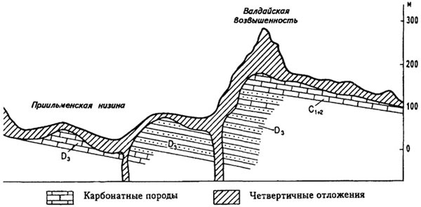
Rice. 27. Geological structure of the Valdai Upland

The zone of coniferous-deciduous forests has long been densely populated and developed, therefore its nature has been greatly changed by human activity. For example, forests occupy only 30% of the territory of the zone, the most convenient plots are plowed up or occupied by pastures; in the animal world, a change in the species composition took place - the tarpans and European tours that once lived in the forests have completely disappeared. Marten, wolverine, desman, golden eagle, osprey, white-tailed eagle, white and gray partridges have become rare. Great work was carried out to restore the river beaver, bison, red deer, increase the number of elk, acclimatize the raccoon dog, American mink and muskrat. Many species of animals and plants have been taken under protection. In the zone, reserves have been established that protect the most typical natural complexes and especially rare animals and plants. Among them is the Prioksko-Terrasny biosphere reserve, which protects the natural complexes of the center of the zone, which played an important role in the restoration of bison brought from Belovezhskaya Pushcha and the Caucasus in the dense coniferous-deciduous forests.
Valdai province stretches from the upper reaches of the Lovati and Western Dvina rivers to the north-north-east to Lake Onega... It is made up of hills Valdai(341 m), Tikhvin(280 m) and Vepsovskaya(304 m), separated by depressions about 100 m above sea level. In the west, the hills abruptly drop off the picturesque Valdai-Onega ledge(up to 150-200 m) to Priilmenskaya lowland... In the east, the hills gradually turn into adjacent low-lying plains.
The province is located on the western flank of the Moscow syneclise; therefore, the sedimentary stratum that composes the cover is monoclinal. The Valdai-Onega scarp is usually considered as a carbonic clint (cuesta scarp), which fixes the boundary of the distribution of Carboniferous rocks, represented by limestones, dolomites and marls. The province is located in the marginal part of the Valdai glaciation, therefore, a well-preserved glacial-accumulative hilly-moraine relief with end-moraine ridges (Torzhok, Vyshnevolotskaya, Lesnaya, etc.) and numerous moraine lakes along the basins ( Seliger, Volgo, Valdai, Veljo and etc.). This strip of young scenic landscapes is called By the lake... The thickness of the moraine covering the preglacial relief varies from 1–2 m to 100 and more meters. The carbonate rocks under the moraine cause the development of karst landforms where the thickness of the Quaternary deposits is small - within the Carboniferous scarp itself and in the valleys of the rivers cutting through it. Karst forms are represented by saucers, ponors, hollows, as well as cavities, caverns, caves.
The sources of the Volga, Dnieper and Western Dvina lie on the Valdai Upland. Many rivers flow in troughs of glacial melt water, and their valleys are not yet fully formed. Short rivers connect numerous lakes, forming a single water system.
The climate of the province is humid with cool summers. The average July temperature is only 16 ° C, and the average daily temperature rarely rises above 20 ° C. Winter is moderately cold. The average January temperature is -9 ...- 10 ° С. Cyclones that often come here cause thaws. The annual precipitation is over 800 mm, which is the maximum for the Russian Plain. The maximum is in the summer.
The province is characterized by an extraordinary diversity of soil and vegetation cover, which is due to the frequent change of parent rocks and landforms. Moraine hills and ridges are covered with broadleaf-spruce forests on sod-podzolic and podzolic soils. Pine forests predominate on outwash plains, lakeside sands and sandy hills. On limestones, dolomites and carbonate moraine, dark-colored humus-calcareous soils are widespread, on which spruce-deciduous forests grow, dominated by oak, with linden, ash and elm in the second tier.
Scattered among the forests are damp meadows and pine-sphagnum low-lying herbaceous and convex ridge-hollow bogs with cloudberries and cranberries. They are confined to the bottoms of wide valleys, lake shores, and sometimes flat watersheds.
A significant part of the province's area was long and strongly changed by man, but in some places weakly changed areas still remain. Here, in 1931, the Central Forest Reserve was created, which now has the status of a biosphere. Its territory is covered with spruce and spruce-deciduous forests typical of the province.
Meshcherskaya province is located between the Klyazma and Oka rivers. In the north, it is limited by the slopes of the Smolensk-Moscow Upland, in the east - by the Oksko-Tsninsky shaft. The typical landscape of Meshchera is a gently undulating alluvial-outwash forest plain 80-150 m above sea level with lakes and swamps. Moraine-erosion rises with average heights of 150-200 m are widespread along the edges of Meshchera. This type of landscape is called woodland... Woodland landscapes formed at the edge of the Pleistocene ice sheet, in depressions of the preglacial relief, along which the flow of melted glacial waters took place. There are also elevated remnants or "loess islands" - opolya. On the East European Plain within Russia, the Polissya type of landscapes forms a whole belt, consisting of Bryansk-Zhizdrinsky, Meshchersky, Mokshinsky, Balakhninsky, Vetluzhsky, Kamsko-Vyatsky and other woodlands.
Meshchera is confined to the preglacial tectonic trough. At its base, there are Carboniferous limestones, overlain by Jurassic and Cretaceous sandy-argillaceous deposits. Quaternary deposits consist of eroded moraine preserved in the highest areas of the preglacial relief ( Egoryevskoe plateau, Oksko-Tsninsky shaft and others), and large strata of sands and loams of water-glacial and alluvial origin. In the central part of Meshchera, there is a lowland with peat bogs and lakes (Svyatoe, Velikoe, etc.). Around it stretch wide strips of sandy plains with dunes. Rivers flow slowly in flat swampy lowlands and drain them poorly.
Meshchera's climate is moderately humid with cold, snowy and long winters. The average January temperature is -11 ...- 12 ° C. Snow lasts up to 150-160 days with a maximum snow cover height of 50-55 cm. Winter types of weather are unstable - with frosts and thaws. Due to the significant amount of snow, the floods on the Meshchera rivers are long. Summers are warm with maximum precipitation. The average July temperature is 18.5-19 ° C. The annual amount of precipitation (about 600 mm) exceeds the evaporation rate, therefore the territory is excessively humid.
The main area of Meshchera is covered with pine forests, in some places with an admixture of oak and swamps. Spruce and birch forests are less common. Sod-podzolic and sod-podzolic-gley soils have formed under the forests on sands and sandy-clay deposits. Light lichen forests are widespread on sandy ramparts, hills and dunes; spruce-pine forests with an admixture of oak, maple and linden dominate in the interfluves along the slopes of the valleys; grow on moraine outcrops mixed forests from spruce, oak and linden, with hazel undergrowth and thick grass cover from snow, clefthoof, lily of the valley; wet oak forests are found on the floodplains.
Swamps occupy about 35% of Meshchera's surface. The main types of bogs are lowland and transitional, among which there are sphagnum-sedge, hypnum-sedge, sedge and birch-sedge. Upper bogs are less common, but they form large tracts and contain thick peat beds (up to 8 m) High Quality... The Shaturskaya thermal power plant operates on Meshchersky peat.
Various landscapes are located in the south of Meshchera in the wide valley of the Oka and the strongly meandering valley of the Pra River, as well as in their interfluve. There in 1935 was created Oksky reserve.
The forest-steppe zone, moderately humid and moderately warm, is located in the south of the Atlantic-continental climatic region of the temperate zone of the East European Plain. Its southern border runs approximately south of Voronezh, Saratov, rises along the Volga valley to the north and goes along the Samara valley. The European forest-steppe is characterized by the main natural features of the entire zone, but at the same time, it differs in its natural appearance from the forest-steppe of the West Siberian Plain, since it has differences in geographic location and the history of the formation of the territory. The forest-steppe stretches from the southwest to the northeast, i.e. occupies the southernmost position in the west of the plain. This determined its bioclimatic features: its western part, up to the meridian of Voronezh, has a semi-humid climate and richer vegetation, and the eastern part is semi-arid with depleted vegetation cover.
Winter in the east is colder and snowy, the average temperature is -12 ° ...- 16 ° С. Summer in the European forest-steppe can be moderately warm with sufficient moisture. Then the vegetation and soils receive a lot of moisture, the groundwater is replenished with a sufficient amount of moisture, their level rises and becomes available in many places for plant roots, the outflows of spring waters in ravines, gullies and river valleys increase. In such a summer, steppe, forest and cultural vegetation develops magnificently (abundantly). Summers can be hot with droughts and dry winds. This type of weather has a detrimental effect on the development of natural and cultivated vegetation. An important bioclimatic zero strip of the ratio of precipitation and evaporation passes through the forest-steppe zone: to the north of it, precipitation is 100-200 mm more than evaporation, and to the south - 100-200 mm less than evaporation.
The East European forest-steppe was formed on the hills and lowlands in the marginal area of the Dnieper glaciation, overlain by loess-like loams. The relief is characterized by erosional dissection, which creates a certain variegation of the soil cover. The soils of the watershed elevated areas under the oak forests are characterized by significant podzolization. The tongues of degraded and leached chernozems extend to the north along high river terraces with loess-like covers. The most typical for the northern part of the zone are gray forest soils, weakly podzolized, developed on loess-like loams. For the southern strip of the forest-steppe, leached and podzolized chernozems are typical. Gray forest soils are developed in small areas along watersheds. Of the intrazonal soils, common in depressions - steppe saucers, malt is characteristic.
The natural vegetation of the forest-steppe is almost not preserved. The forests are found here as small islands. Forest-steppe Russian plain oak, which distinguishes it from the more eastern regions of Russia. The main forest-forming species in the European forest-steppe is the pedunculate oak, which is mixed with Norway and Tartar maples, elm and ash; in the shrub undergrowth - hazel, warty euonymus, honeysuckle, etc. In the floodplains, in well-drained areas, oak forests are also found, and on the terraces there are mixed oak-pine forests of Scots pine, pedunculate oak, etc.
The steppe areas in the forest-steppe, once covered mainly with forbs (V.V. Alekhin called them northern colorful forbs), are plowed up. Small patches of virgin steppes remained on the beams and on the coastal slopes, inconvenient for plowing, as well as in reserves.
The fauna of the zone consists of the inhabitants of forests and steppes. There are no own species here. Due to the strong plowing of the zone in the animal world, animals of open spaces and human companions now prevail.
Five provinces are distinguished within the forest-steppe zone.
The Central Russian province is located on the hill of the same name in the westernmost part of the zone. The northern border of the province runs approximately along the sub-latitudinal section of the Oka. The upland formed within the Voronezh anteclise, which is characterized by uplifts over a long history of geological development, including the modern era. Slightly south of the latitude of Kursk - Voronezh, the basement rocks come closest to the surface (100-200 m). The largest iron ore deposit of the Kursk Magnetic Anomaly is associated with the Precambrian crystalline rocks (gneisses and granites). The basement rocks are overlain here by Upper Cretaceous strata with a predominance of writing chalk, and in some places also by sandy-argillaceous deposits of the Paleogene and Miocene.
In the north, the gentle slope of the Voronezh anteclise is covered with Devonian limestones, sandstones and clays. They are opened by rivers in the Don and Oka basins, where they form picturesque indigenous banks. To the north, the Devonian layers subside and limestones of the Carboniferous come out to the surface, among which lies the clay-coal-bearing stratum of the Moscow basin, belonging to the Lower Carboniferous. Deposits of brown coal are associated with it, as well as sedimentary iron ore... On the watersheds, Carboniferous rocks are overlain by sandy-clayey Jurassic and Cretaceous strata, which are washed away near rivers.
Of the Quaternary deposits, brown carbonate loess-like loams and reddish-brown clays are widespread. Loess-like loams in the south pass into uneven-aged loess. Their power is different. On watersheds, they are often completely absent or reach 2-3 m, on the slopes of river valleys and gullies, their thickness is 10-12 m.
In the Neogene-Quaternary time, the entire territory experienced uplifts up to 200 m, which determined the formation of a step-tiered plain here with a height of up to 293 m above sea level and its intense erosional dissection.
Lithology has a great influence on the formation of the relief of various parts of the upland. Its northern part, up to the parallel of Orel, where limestones are widely represented, is sharply dissected by deep river valleys. On the slopes of the valleys, solid layers of limestone form steep and rocky walls, cornices, cliffs. Limestones contribute to the creation of small canyon-like valleys, the development of karst forms. In the middle and southern parts of the territory, where loose strata are developed, wide terraced valleys with sloping slopes prevail. Sharper relief forms are confined to the places of distribution of writing chalk. Such a deeply dissected relief with a large amplitude of relative heights is observed near Belgorod. The depth of the incision here reaches 150-125 m. In the loess strata, ravines with steep walls have arisen. Landslides are formed on the slopes of all erosional forms.
Various erosional forms are developed on the entire upland - valleys, gullies, ravines, represented by several types. Here are also common karst forms relief. Therefore, the Central Russian Upland can be attributed to the region of the classic gully-ravine relief in combination with limestone and chalk karst.
The elevated, rugged relief of the province affects its climate. Summers are cool here, and the annual amount of precipitation is slightly higher than in the adjacent lowlands. The average July temperature is 19 ° C in the northwest and 23 ° C in the southeast. The maximum precipitation falls in July (60-70 mm). But the summer is dry too. Winter is moderately cold: the average January temperature is -8 ...- 10 ° С. Absolute minimum is equal to -35 ...- 40 ° С. The maximum height of the snow cover reaches 30-45 cm in the third decade of February. The annual amount is about 600 mm on the western slope, and up to 500 mm on the eastern slope. Precipitation gradually decreases from northwest to southeast.
The dense river network of the province dissects its surface in all directions. The Oka begins almost in the center and goes to the north with numerous tributaries (Zhizdra, Zusha, Upa, Tarusa). The rivers of the western part carry their waters to the Dnieper. The Don flows along the eastern edge of the hill and receives the waters of the Beautiful Swords, Pines, Seversky Donets with Oskol. In summer, many small rivers dry up and their valleys look like ancient gullies.
The Central Russian province is dominated by gray forest soils, as well as leached and podzolized chernozems. The vegetation of the province has been greatly modified by humans. Before human intervention, almost the entire northwestern part of the upland was covered with oak forests. Nowadays there are only small tracts of forests (Tula Zaseki). In the southwestern part of the upland, on the Vorskla River, centuries-old oak forests have been preserved. These forests consist of pedunculate oak with small-leaved linden, ash, maple, birch and aspen. In the subzone of a typical oak forest-steppe, modern forests are represented by gully oak forests, which have survived to this day in only a few places and in small areas.
In the south of the upland, within the limits of the outcropping of chalk deposits, pine forests of chalk pine are developed, which have also been preserved in a few places (the Oskol region, the right bank of the Potudan, etc.). They are called chalk forests. These are ancient, still preglacial forests of the Central Russian Upland.
Remnants of the former steppe vegetation have been preserved on the steep, steep slopes of the valleys, in deep winding ravines and ravines. On these surviving areas, forest-steppe reserves were formed: Central Black Earth them. V.V. Alekhina, Galichya Mountain, Forest on Vorskla.
At the end of the last century, botanists discovered an interesting steep cliff of the Don River - Galich Mountain. The most valuable for science, scientists consider the vegetation of steep cliffs. Here ancient species have been preserved from the preglacial and postglacial times. These are relic plants. Among them, the most interesting are the tertiary forest shrubs - the Sofia wolfberry and the representative of mountain alpine meadows - the furry breakthrough.
The steppe zone extends from the southern border of the forest-steppe zone to the Kumo-Manych depression in the south. It reaches its greatest width at 42 ° E. To the east, it becomes narrower and shifts sharply to the north. The steppe zone is located on the southern erosional-accumulative loess plains.
The steppe climate is not humid enough, with warm summers and cold winters. Winter is especially severe for these latitudes in the Trans-Volga steppes. The average January temperature here is -14 ...- 16 ° С. The Azov steppes are distinguished by milder winters with an average January temperature of -4 ...- 6 ° C. Summer temperatures in the steppe zone are everywhere +21 ... + 23 ° С, and the sum of temperatures for the period with an average daily temperature above + 10 ° С reaches 2800-3000 °. There is not enough moisture in the steppes. During the year, the western steppes of Russia receive 500 mm of precipitation, and the Middle Volga region - about 400 mm. At high air temperatures in the steppes, evaporation exceeds the amount of precipitation by 200-400 mm, which leads to insufficient moisture. Dry winds are frequent here, in the east their total duration is 20-30 days.
The northern steppes are less warm, but more humid than the southern ones. Therefore, the steppe zone is divided into two subzones: northern and southern. Ordinary and southern chernozems have formed in the northern steppe under the herb-fescue-feather grass vegetation. In the southern drier steppes, dark chestnut and chestnut soils are widespread under sod-grass steppes with Ukrainian feathergrass, hairs and fescue. Their distinctive feature solonetsousness, expressed in varying degrees.
Among the steppe plants, Western European species grow, some of them are classified as Tertiary relics, for example, the bluish rank is a Balkan relic, the large-flowered pollen head is an endangered European-Mediterranean species. Some endemic relics have survived - Taliev's cornflower, Don serpukha, Don gorse, feather grass.
In the steppe zone, woody vegetation is found only in river floodplains. In the floodplain of the Don, for example, poplar, wild carp, willow, alder, oak, aspen, elm, maple, willow, etc. grow.
Rodents predominate among the animals of the steppes: ground squirrels, mole voles, field mice, hamsters. They are hunted by ferrets, foxes, weasels and feathered predators - eagles, hawks, falcons. Larks and the steppe harrier are also widespread among birds, but the bustard and little bustard are rare. Many steppe insects have become very rare in nature, therefore they are included in the Red Data Books, for example, steppe grasshopper, steppe bumblebee, alpine barbel, butterflies - Apollo, mnemosyne, a solitary bear, several bluebirds, etc. Therefore, microreserves of insects began to be organized. One of the first such reserves was created in Voronezh region among fields on an area of 1 hectare. Beneficial insects, including plant pollinators, are protected here.
The steppes of the East European Plain have long been mastered by man, the most fertile soils have been plowed up; chernozems on which wheat, barley, corn, legumes, industrial and melon crops are cultivated. Thousands of kilometers of state-owned forest belts stretch across the steppe zone. The largest forest plantations in the steppe stretch from Saratov to Volgograd, then to Elista. The near-valley Don forest belts are created from Voronezh to Rostov. Protective afforestation is carried out in the sands of the lower Don basins.
Since the last century, ponds have been created in ravines and gullies and the banks of reservoirs have been landscaped.
Semi-desert and desert zones within Russia are located in the southwestern part of the Caspian lowland and on the Ergeni Upland. They adjoin the coast of the Caspian Sea, merge with the semi-deserts and deserts of Kazakhstan in the east and the Eastern Ciscaucasia in the southwest. The arid landscapes of the Caspian Sea began to form on the low-lying sea plains after the retreat of the Khvalynsk Sea about 20 thousand years ago.
The climate of semi-deserts and deserts is moderately dry and very warm with an annual rainfall of 300-400 mm. Evaporation rate exceeds precipitation by 400-700 mm. Winters are cold enough, freezing temperatures prevail. The average January temperature in the southwest is -7 ° С, and in the northeast -11 ° С. In winter, the snow cover is formed, the height of which reaches 10-15 cm. Snow lasts 60-80 days. In the extreme south of the Caspian lowland, a stable snow cover does not form every year. It usually forms 15-30 days later than the transition of the average daily temperature through 0 ° C. This contributes to the seasonal freezing of the soil to a depth of 80 cm (about the same amount as in the middle taiga).
The semi-desert and desert of the Caspian lowland are distinguished by an abundance of salt lakes, salt marshes and salt licks. Therefore, there are developed light chestnut solonetzic soils, the absorbing complex of which contains sodium. The thickness of the humus horizons is 30-40 cm, and the humus content is only 1.3%. In the north of the semi-desert zone, the vegetation of the wormwood-cereal type is developed with the predominance of feather grass of hairwort (tyrsa) and Lessing, as well as Tauric wormwood and Lerkha. To the south, the number of cereals decreases, wormwood begins to predominate, and the number of saltwort increases. The undersized grass cover consists of white and black wormwood, fescue, fine-legged, xerophytic feather-grass, izen dwarf shrub (prostrate kochia). Tulips, buttercup, rhubarb appear in spring. White wormwood grows on slightly saline loams. Clayy, more saline soils are covered with black wormwood. On the salt licks, in addition to black wormwood, the saltwort biyurgun and kermek and the tamarik shrub grow. In the Astrakhan Trans-Volga region, sands are widespread, which are characterized by the gramineous grain, or kiyak, which is a sand fixer. There is a Siberian wheatgrass, which is of great fodder value. Willow, white poplar, black poplar, aspen, elk, and wild rose grow in wet hollows. An oak is found in the Volga floodplain.
For the fauna of semi-deserts and deserts, ground squirrels are common, there are many jerboas, of which the small, earthen bunny, uphill-footed is characteristic. There are numerous gerbils - comb, southern, or midday, inhabiting mainly sands. The ermine, weasel, steppe ferret, badger, wolf, common fox and small corsac fox are widespread, there are many reptiles. Larks are typical birds of the semi-desert. White-winged lark nests on the outskirts of salt licks. On the self-deposited lakes, sea plovers and sheath ducks are common. The Volga delta is characterized by the great cormorant. Of the geese, the gray goose and the egret nest in the delta. Sultan's chicken and pheasant are rare. The baleen tit is widespread in the coastal strip.
Some species of plants and animals are included in the Red Data Books. For example, a rare endemic - Regel's bow, Taliev's cornflower, giant mole rat, dressing, bustard, little bustard, etc.
Sea to the northern slopes of the Kazakh Upland for 2.5 thousand km. In the northern part, the plain stretches from the Urals up to 1000 km, and in the southern part - almost 2 thousand km. The entire plain lies on the West Siberian plate with a deeply submerged folded basement of the Paleozoic age. It is overlain by sedimentary strata of the Mesozoic, Paleogene and Quaternary ages of enormous thickness, reaching 6 thousand meters. They are represented by clays, sandstones, sands and shales. Quaternary strata consist of sea, river and glacial deposits: loams, sands and clays. During the revival of the Ural and loose sedimentary strata of the West Siberian plate, they were slightly deformed. Folds appeared in them, which led to the formation of underground domes. In such domes, composed of sands, overlain by impermeable dense clays, there was an accumulation of oil and. Largest deposits in the Surgut region, gas - in the Urengoy region and on the peninsula. In the south of the plain, where the folded basement is raised, there are deposits of ore. The largest of them is Sokolovsko-Sarbayskoe.
The thick horizontally lying sedimentary strata determines the flatness of the modern one. The northern and central parts of Western Siberia are lowlands located at an altitude of up to 100 m above sea level. The southern part of the plain rises slightly higher. In general, Western Siberia has the shape of a huge bowl, rising slightly to the south, west and east and tilting to the north. The northern most lowered part of the plain is separated from the rest of the narrow, elongated in the latitudinal direction by the upland of the Siberian Uvaly.
Rivers flow slowly over the slightly sloping plain. They are shallowly incised and form extensive meanders and channels with an unstable channel. During spring floods, they spread widely.
The flat surface of the northern half of the territory, weak drainage associated with shallow incisions, excessive moisture, an abundance of incoming from the raised edges of the plain - all this led to the formation of extensive ones. Western Siberia is the most swampy plain in the world. Swampiness is 38%.
The inland position of Western Siberia determined its continentality, especially in the south of the plain. Average January temperatures vary from -25 ° C in the north to -18 ° C in the south. Mid-July - from + 2 ° С on the coast zoning. The extreme north on the Tazovsky and Gydansky peninsulas is occupied by the tundra zone. descends to the south almost to the Siberian Uvaly. It features larch and birch crooked forests. In the south of the forest-tundra, pine and cedar appear in larch forests. Forests go far to the north along the rivers, as the river valleys are drier because of better drainage, and heat comes from the south with river water. In the tundra and forest-tundra zone, there are pastures where herds of reindeer many thousands graze. Rich prey is provided by commercial hunting (fox skins) and fishing. Gas production is in progress.
Sixty percent of the territory of Western Siberia is occupied by a forest bog zone. Swamps dominate the interfluvial areas. forests grow mainly on the slopes of river valleys and narrow sandy rises in the interfluve - manes. Pine forests prevail in the western part of the Ural region. In the northern and middle parts of the plain, spruce-cedar and larch forests dominate, in the southern - taiga of spruce, cedar, fir, birch. In the taiga, they hunt sable, squirrel, marten, muskrat and mink. To the south, the taiga is replaced by birch-aspen, which turn into. It consists of grassy groves with numerous birch-aspen groves in depressions (groves). The extreme south of Western Siberia is occupied by the steppe zone, where chernozems and dark chestnut soils have formed in an arid climate. They are almost completely plowed up. On vast tracts of former virgin lands, there are fields of spring wheat. The plowing of the steppes led to dust storms. At present, in the vast expanses of the south of Western Siberia, special methods of moldboard-free tillage are used, in which the stubble of grain crops is preserved. It promotes the accumulation of snow, protects against blowing. There are many salt lakes in the steppes, where soda and table salt are mined.
WESTERN SIBERIAN PLAIN (West Siberian Lowland), one of the largest plains the globe. Located in the northern part of Asia, in Russia and Kazakhstan. The area is over 3 million km 2, including 2.6 million km 2 in Russia. The length from west to east is from 900 km (in the north) to 2000 (in the south), from north to south up to 2500 km. In the north it is washed by the Arctic Ocean; in the west it borders on the Urals, in the south - on the Turgai plateau and the Kazakh hills, in the southeast - on the mountains of Southern Siberia, in the east - along the Yenisei river valley with the Central Siberian plateau.
Relief... It is a low accumulative plain with a rather uniform relief, various forms of permafrost (widespread up to 59 ° north latitude), increased swampiness, and ancient and modern salt accumulation developed in the south in loose rocks and soils. Heights of about 150 m prevail.In the north, in the area of distribution of marine accumulative and moraine plains, the general flatness of the territory is disturbed by gently sloping moraine and hilly-ridged (Severo-Sosvinskaya, Lyulimvor, Verkhne-, Srednetazovskaya, etc.) uplands with a height of 200-300 m, the southern border of which runs about 61-62 ° north latitude; they are covered like a horseshoe from the south by the flat-topped uplands of the Belogorsk Continent, Sibirskie Uvaly, and others. In the northern part, permafrost exogenous processes (thermal erosion, soil swelling, solifluction) are widely developed, deflation on sandy surfaces, and peat accumulation in swamps. There are numerous ravines on the plains of the Yamal and Gydansky peninsulas and on the moraine uplands. To the south, flat lacustrine-alluvial lowlands adjoin the area of moraine relief, the lowest (height 40-80 m) and swampy of which are Kondinskaya and Sredneobskaya. The area not covered by the Quaternary glaciation (south of the Ivdel - Ishim - Novosibirsk - Tomsk - Krasnoyarsk line) is a weakly dissected denudation plain that rises (up to 250 m) towards the Urals. In the interfluve of the Tobol and the Irtysh, there is a sloping, in places with ridged ridges, lacustrine-alluvial Ishim plain (120-220 m) with a thin cover of loess-like loams and loesses overlying saline clays. It is adjacent to the alluvial Baraba Lowland and the Kulunda Plain, where the processes of deflation and modern salt accumulation are developing. In the foothills of Altai - ridge-ridged Priobskoe plateau (height up to 317 m - highest point West Siberian Plain) and Chulym Plain. O geological structure and minerals, see the article West Siberian Platform, with which the West Siberian Plain is geo-structurally connected.
Climate... Prevails continental climate... Winter in polar latitudes differs in severity and duration up to 8 months (the polar night lasts almost 3 months), average January temperatures are from -23 to -30 ° С; in the central part, winter lasts up to 7 months, average January temperatures are from -20 to -22 ° С; in the south, where the influence of the Asian anticyclone increases, at the same temperatures the winter is shorter (up to 5-6 months). The minimum air temperature is -56 ° С. In summer, the western transport of Atlantic air masses predominates during invasions in the north of cold air from the Arctic, and in the south - dry warm air masses from Kazakhstan and Central Asia... In the north, summers are short, cool and humid with polar days, in the central part - moderately warm and humid, in the south - arid and dry, with dry winds and dust storms. The average July temperature rises from 5 ° С in the Far North to 21-22 ° С in the south. The growing season in the south is 175-180 days. Precipitation fall mainly in summer. The wettest (400-550 mm per year) are the Kondinskaya and Sredneobskaya lowlands. To the north and south, the annual precipitation gradually decreases to 250 mm.
Surface waters. There are more than 2000 rivers in the West Siberian Plain that belong to the basin of the Arctic Ocean. Their total runoff is about 1200 km 3 of water per year; up to 80% of the annual runoff occurs in spring and summer. The largest rivers are the Ob, Yenisei, Irtysh, Taz and their tributaries. The rivers are fed by mixed (snow and rain), the spring flood is extended, the low-water period is prolonged in summer-autumn and winter. Ice cover on rivers lasts up to 8 months in the north, and up to 5 months in the south. Major rivers navigable, important floating and transport routes and, in addition, possess large reserves of hydropower resources. The total area of the lakes is more than 100 thousand km 2. Largest lakes located in the south - Chany, Ubinskoe, Kulundinskoe. In the north, there are lakes of thermokarst and moraine-glacial origin. In the suffosion depressions there are many small lakes (less than 1 km 2): in the Tobol-Irtysh interfluve - more than 1500, on the Barabinskaya lowland - 2500, including fresh, salty and bitter-salty; there are self-deposited lakes.
Types of landscapes. The uniformity of the relief of the vast West Siberian Plain determines a clearly expressed latitudinal zoning landscapes, although compared to the East European Plain natural areas here they are shifted to the north. On the Yamal, Tazovsky, and Gydansky peninsulas, under conditions of continuous permafrost, landscapes of the Arctic and subarctic tundra with moss, lichen, and shrub (dwarf birch, willow, alder) cover were formed on gleys, peat-gley turf soils, peat bogs and soils. Polygonal mineral herbal-hypnum bogs are widespread. The share of native landscapes is extremely insignificant. To the south, tundra landscapes and bogs (mostly flat-hilly) are combined with larch and spruce-larch woodlands on podzolic-gley and peat-podzolic-gley soils, forming a narrow zone of forest tundra, transitional to the forest (forest bog, represented by the northern zone of the temperate zone) and southern taiga. Common to all subzones is swampiness: over 50% of the northern taiga area, about 70% - middle, about 50% - southern. The northern taiga is characterized by flat and large-hilly raised bogs, the middle taiga is characterized by ridge-hollow and ridge-lake bogs, and the southern taiga is characterized by hollow-ridge, pine-shrub-sphagnum, transitional sedge-sphagnum and low-lying arboreal sedge. The largest swamp massif is the Vasyugan Plain. The forest complexes of different subzones, formed on slopes with varying degrees of drainage, are peculiar. Northern taiga forest complexes on permafrost are represented by sparse and undersized pine, pine-spruce and spruce-fir forests on gley-podzolic and podzolic-gley soils. The native landscapes of the northern taiga occupy 11% of the area of the West Siberian Plain. Common to the forest landscapes of the middle and southern taiga is the wide distribution of lichen and dwarf-shrub-phosphagnum pine forests on sandy and sandy loamy-ferruginous and illuvial-humus podzols. On loams in the middle taiga, spruce-cedar forests with larch and birch forests are developed on podzolic, podzolic-gley, peat-podzolic-gley and gley peat-podzols. In the subzone of the southern taiga, on loams, there are spruce-fir small-grass forests and birch forests with aspen on sod-podzolic and sod-podzolic-gley soils (including those with a second humus horizon) and peat-podzolic-gley soils. Indigenous landscapes in the middle taiga occupy 6% of the area of the West Siberian Plain, in the southern - 4%. The subtaiga zone is represented by park pine, birch, and birch-aspen forests on gray, gray gley and sod-podzolic soils (including those with a second humus horizon) in a complex with steppe meadows on cryptogley chernozems, in places solonetzic. The indigenous forest and meadow landscapes are practically not preserved. Swampy forests turn into low-lying sedge-hypnum (with ryamas) and sedge-reed bogs (about 40% of the territory of the zone). For forest-steppe landscapes of sloping plains with loess-like and loess-like coverings on saline tertiary clays, birch and aspen-birch outcrops are typical on gray soils and malts in a complex with grass-grass steppe meadows on leached and black-gleaned meadows, more southern black soil meadows are more southern solonetzic and saline. There are pine forests on the sands. Up to 20% of the zone is occupied by eutrophic reed-sedge bogs. In the steppe zone, indigenous landscapes have not been preserved; in the past, these were grass-feather grass steppe meadows on ordinary and southern chernozems, sometimes saline, and in drier southern regions- fescue-feather grass steppes on chestnut and cryptogley soils, gley solonetzes and salt marshes.
Environmental problems and protected natural areas. In the areas of oil production, due to pipeline breakthroughs, water and soil are polluted with oil and oil products. In forestry areas - cuttings, waterlogging, the spread of silkworms, fires. In agricultural landscapes, there is an acute problem of lack of fresh water, secondary soil salinization, destruction of the soil structure and loss of soil fertility during plowing, drought and dust storms. In the north, there is degradation of reindeer pastures, in particular due to overgrazing, which leads to a sharp decline in their biodiversity. The problem of preserving hunting grounds and natural habitats of fauna is no less important.
For the study and protection of typical and rare natural landscapes, numerous reserves, national and natural parks... Among the largest reserves: in the tundra - the Gydansky reserve, in the northern taiga - the Verkhnetazovsky reserve, in the middle taiga - the Yugansky reserve, etc. national park- Priishimskie Bory. Natural parks have also been organized: in the tundra - Deer streams, in the northern taiga - Numto, Siberian Uvaly, in the middle taiga - Kondinsky lakes, in the forest-steppe - Bird's harbor.
Lit .: Trofimov V. T. Regularities of spatial variability of engineering-geological conditions of the West Siberian plate. M., 1977; Gvozdetsky N.A., Mikhailov N.I. Physical geography of the USSR: Asian part. 4th ed. M., 1987; Soil cover and land resources of the Russian Federation. M., 2001.