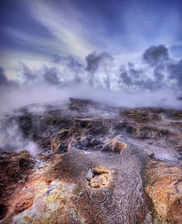
Geotechnical monitoring(hereinafter referred to as monitoring) on permafrost soils - a set of works based on field observations of the state of the foundation soils (temperature regime), hydrogeological regime, movement of foundation structures of a newly erected, reconstructed and operated structure.
In areas where permafrost soils are spread, monitoring must be carried out for all types of buildings and structures, including underground utilities.
Monitoring is carried out in accordance with the project, which is developed in the design process and is a section of the approved part of the design documentation.
When developing a monitoring project, the composition, volumes, frequency, timing and methods of work, schemes for the installation of observation wells, geodetic marks and benchmarks, sensors and instruments are determined, which are assigned in relation to the considered construction (reconstruction) object, taking into account its specifics, including: the results of engineering surveys at the construction site, the principle of using permafrost soils as foundations, features of the designed or reconstructed structure and structures of the surrounding buildings, etc.
The monitoring project should take into account the factors influencing the newly erected (reconstructed) structure, its foundation, the surrounding soil massif and surrounding buildings during construction and operation, incl. the possibility of manifestation of dangerous geocryological processes (cryogenic heaving, thermokarst, landslide processes, surface subsidence during thawing, etc.), as well as thermal effects from construction work.
For monitoring during the construction period, control thermometric and hydrogeological wells are equipped, permanent geodetic marks are installed on the foundations of the structures, according to which measurements of soil temperature, groundwater level, their composition and temperature, leveling of foundations, including submerged piles, are measured paths of overhead cranes, drainage trays in technical floors and underground buildings, as well as sidewalks near structures.
Places of installation of thermometric and hydrogeological wells, geodetic marks, the frequency of measurements are established according to the appendices of SNiP 2.02.04-88 (updated edition). In addition, the density of soils laid in embankments is monitored when replacing soils in excavations and when territory is reclaimed. Thermometric wells are equipped in accordance with GOST 25358-82, hydrogeological wells - SP 11-105-97 (Parts I, IV), leveling marks and geodetic measurements are carried out in accordance with GOST 24846-81.
During the period of operation of the structure, monitoring is carried out in order to ensure the design regime of the foundation soils and the condition of the foundations of the structure. The monitoring includes the following types of work:
- routine and control inspection of the condition of technical floors, subfields of buildings and communications and other devices located in them;
- monitoring the condition of concrete foundations;
- monitoring the temperature of the soil at the base of structures;
- monitoring the air temperature in the underground;
- observation of the settlements of foundations;
- observation of the hydrogeological regime of the foundation.
The duration of monitoring depends on the principle of construction and is for structures built according to:
- I principle - during the entire period of operation of the structure;
- II principle:
a) using preliminary soil thawing - within 5 years;
b) with the admission of thawing during operation - within 10 years.
The duration of monitoring can be reduced when changes in monitored parameters are stabilized, or increased in the absence of stabilization of changes in monitored parameters.
During the monitoring process, it is necessary to ensure the timely informing of interested parties about the identified deviations of the controlled parameters (including the tendencies of their changes exceeding the expected ones) from the design values and the results of thermal and geotechnical forecast.
Environmental requirements for the design and construction of foundations and foundations on permafrost soils
The design of foundations and foundations on permafrost should provide for measures to ensure the prevention, minimization or elimination of harmful and undesirable environmental and related social, economic and other consequences.
Environmental requirements taken into account in design and construction are based on the results of engineering and environmental surveys carried out in accordance with SP II-102 and SP II-105, which assess the condition the environment and forecast of the impact of the construction object on it.
The forecast of the impact on natural conditions is carried out for the entire period of construction and operation of buildings and structures and must establish:
- the possibility of changing the thermal regime of permafrost soils in the construction area and adjacent territories due to violations of heat transfer conditions as a result of construction and temperature exposure during operation;
- changes in the hydrogeological conditions of the construction site as a result of earthworks, including ways of unloading surface and suprapermafrost waters through drainage canals;
- the degree of activation of dangerous geocryological processes, including: precipitation and heaving of soils, thermokarst, solifluction, erosion, soil erosion, etc.;
- the possibility of the occurrence of slope processes and waterlogging of the territory.
Taking into account the results of engineering and geological surveys, design solutions are selected and measures are developed for the reclamation and restoration of the soil and vegetation layer, backfilling of excavations, trenches and quarries, flattening and sodding of slopes and slopes, as well as to prevent erosion, thermokarst and soil erosion processes.
The main measures for environmental protection during the construction of foundations and foundations on permafrost soils are developed at the stage of feasibility study.
Design documentation for the construction of foundations and foundations on permafrost soils at the "P" stage should include a separate section "Environmental protection".
It is allowed to start the production of work on the construction of foundations and foundations only if there are POS and projects for engineering preparation and protection from dangerous permafrost processes and flooding of the territory, which specifically reflect all the features of the permafrost and soil conditions of the construction site. The construction organization project must necessarily provide for the exact timing and features of the work, as well as measures to restore damaged areas of the construction site.
 General information about permafrost for geotechnical monitoring
The geological activity of ice is an object of study in special sciences - glaciology and geocryology. Glaciology Is the science of the physical properties of glaciers, their origin, development, geological activity and the impact on the formation the earth's surface... Geocryology (permafrost) studies the patterns of formation and distribution of permafrost and geological processes occurring in the permafrost zone of the lithosphere.
It is customary to refer to the frozen zone of the lithosphere the areas of development of such rocks, which are characterized by zero or negative temperatures and the presence of ice in them, enclosed in pores and cracks.
Rocks can obey climatic changes: seasonal freezing and thawing, but they can also be permafrost. The antiquity of permafrost is confirmed by archaeological and paleontological finds. So, on the Anadyr Peninsula, near Lake Chirovoy, in loams lying in the cracks of the ice hillock, N. Grave discovered the remains of the site of an ancient man who lived here in the Upper Neolithic, at least 2000 years ago.
Isotopic methods have established that well-preserved remains of mammoths are many millennia old. The Taimyr mammoth died 12 thousand years ago. Based on these data, permafrost rocks are those rocks in which negative temperatures persist continuously for millennia and tens of thousands of years.
Permafrost rocks in Russia are located mainly in Siberia, where the southern border of their distribution runs south of Lake Baikal. The northern border roughly coincides with the Arctic Circle. Along the southern boundary of permafrost, an insular nature of its distribution is noted. Total for the globe 23% of the land area is covered with "permafrost"; the largest areas of its distribution are also Canada (6 million km 2), Greenland (1.6 million km 2), Alaska (1.5 million km 2), Antarctica (12,980,000 km 2).
 Ice within the distribution of permafrost rocks can occur in the form of ice-cement, vein, repeated, buried and cave ice. Ice-cement fetters mineral formations, holding and cementing them. Vein ice fills cracks in rocks.
Rewire ice penetrates into rocks through frost cracks deeper than the border of their seasonal freezing. It can grow not only vertically, but also horizontally and form large clusters. It was found that such ice masses were continuously formed during the entire Quaternary period. Actually buried ice are observed in the zones of modern glaciations inside the deposited moraines and under them.
Cave ice are formed in a variety of cavities. They can also be found outside the zone of distribution of permafrost rocks (for example, in the Kungur cave). Such ices are solid ice masses, or drip forms (pillars, draperies), or individual crystals on the walls and ceiling of caves.
Lateral distribution of permafrost
 Distinguish between seasonal and permafrost.
Seasonal permafrost exists only in winter, perennial - persists all year round and for many years. The most vivid and large-scale permafrost (cryogenic) processes are manifested in the permafrost zone, i.e. in the area of permafrost distribution. Permafrost is especially widespread in the north of Eurasia and North America... In Russia, it occupies about 2/3 of the entire territory - mainly in Siberia and the Far East. When mastering huge natural resources these regions require a detailed study of permafrost conditions and processes, since they very often turn out to be a decisive factor that seriously complicates all types of construction.
In the direction from north to south within the permafrost zone of the Northern Hemisphere, as the permafrost area and thickness decrease, three subzones are distinguished: continuous, discontinuous and sporadic distribution of permafrost soils. In the subzone continuous distribution the thickness of the permafrost is measured in hundreds of meters (usually from 100 to 500 m), sometimes reaching 1 km or more. Harsh climatic conditions in this subzone, the most favorable for the formation of permafrost, however, taliks are also found here - areas where frozen strata are absent.
Taliki are developed mainly under rivers and lakes, which are abundant enough for the warming effect of the water to prevent freezing.
In the subzone discontinuous propagation the thickness of the permafrost usually does not exceed 100 m. Taliki occupies a much larger area here, and the formation of new permafrost is limited. Finally, the southern subzone of sporadic distribution can be considered as an area of predominant permafrost degradation.
Thus, being in many regions not only a modern formation, but also a relic of the glacial epochs, permafrost persists to this day due to the sharply continental climate with long cold and little snowy winters.
Vertical spread of permafrost
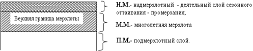
Three layers are distinguished in the vertical section of the permafrost zone (polar cover complex, according to A.I. Popov, 1967). Upper layer called active, this is the layer of seasonal thawing. Its thickness as a whole increases from north to south up to three to four meters and depends on the thermal conductivity and water permeability of rocks: sandy soils thaw deeper than clay soils, which, in turn, are deeper than peat. In the active layer, rocks regularly pass from frozen to thawed state and back, which is expressed in cryoturbation- mixing of soil, which is associated with the formation of specific forms of permafrost microrelief.
The active layer is underlain by thick, permanently frozen strata. At the top of them ( second layer), seasonal fluctuations in negative temperatures still occur, which are accompanied by mechanical stresses and cracking. Even lower, starting from a depth of about 10 m, the negative temperature of the rocks remains constant throughout the year - this is third most powerful layer, a kind of foundation of the permafrost.
 Seasonally frozen soils that occur wherever negative winter temperatures are held for a certain time, in fact, consist of one active layer. However, the processes occurring in it (swelling, soil sorting, cracking, etc.) are not as active as in the active layer of the permafrost zone, due to the absence of underlying permafrost, which plays the role of an aquiclude and affects the distribution of pressure in the soil.
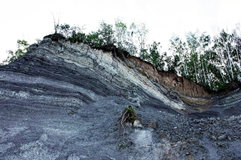
Permafrost development can proceed epigenetically(the previously formed rock freezes) and syngenetically(the formation of the soil and its freezing occur simultaneously). The first path is typical for uplands, where denudation predominates, and as the weathering crust is removed, freezing penetrates deep into the strata of the rocks. The second path is typical for lowlands, where accumulative processes dominate, for example, the accumulation of alluvium in river valleys.
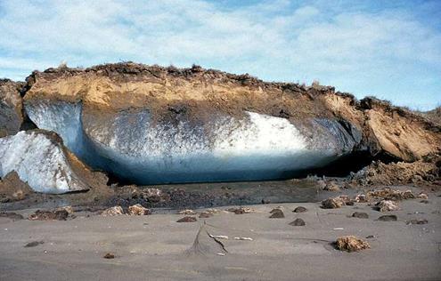
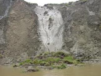
As an integral component of frozen soils, underground ice can be found in them in various forms - from pore and capillary to large ice lenses and veins. Usually distinguish: ice-cement- without accumulations scattered between particles of loose rock; segregation ice- has the form of ice interlayers, which stand out during freezing of finely dispersed (clay and silty) soils; injection ice- is formed when water penetrates into cracks and aquifers; polygonal wedge ice- formed as a result of freezing in frost cracks of water trapped in them from the surface. In addition, underground ice can be buried- This is the former ground ice, covered with mineral sediments.
Permafrost (cryogenic) processes and landforms
The main permafrost processes include: frost cracking, frost sorting of loose material, heaving and formation of ice, frost weathering, cryogenic creep, solifluction, thermokarst. Most of the permafrost landforms are of complex origin, i.e. various cryogenic processes took part in their formation. Cryogenesis occurs mainly in the two upper elements of the polar cover complex, with the greatest activity associated with the active layer. Therefore, permafrost forms are usually small in size and belong to micro- or mesorelief. They are located on the surface of larger forms that are of tectonic, erosional or other origin.
The nature of cryogenic relief formation is influenced by numerous factors: climate, epigenetic or syngenetic freezing, thickness and ice content of frozen rocks, mechanical composition of soils in the active layer, exposure and slope of slopes, etc. This leads to the fact that permafrost forms of the same type, but from different regions, sometimes differ significantly from each other.
Frost cracking
Occurs with strong and rapid soil cooling, usually on clear winter nights. The penetration depth of cracks reaches 3-5 m and more. The network of frost cracks, as a rule, has ordered outlines, forming a pattern of polygons (four, five, or hexagons). The largest polygons are observed within the low-lying coastal plains, where higher air humidity softens daily temperature contrasts. On the contrary, the densest network of cracks occurs in sharply continental conditions.
In the warm season, frost cracks are filled with water and liquefied soil. In autumn, the water freezes, forming veins, which repeatedly grow and significantly widen the cracks - up to the first meters near the surface.
If the climate in a given area becomes warmer and the polygonal-veined ice melts, then the cracks expanded by them are filled with mineral soil - this is how ground veins... In most cases, such ground veins in a buried state serve as an important paleogeographic evidence of the existence of permafrost here in the past.
Frost sorting
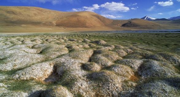
This sorting often complements frost cracking. It is heterogeneous in terms of the texture of the soils of the active layer. The result of their joint work is stone polygons or, less commonly, stone rings... Frost sorting processes are as follows. Fine-grained (sandy-clayey) soil areas, having a high moisture capacity, significantly increase in volume when frozen. At the same time, they push out larger debris (crushed stone, pebbles, boulders) to the surface and towards frost cracks. Multiple repetition of freezing-thawing gradually leads to a clearly pronounced differentiation of the soil, which is usually observed only in the upper part of the active layer (up to 0.5 - 0.8 m) and gradually fades with depth.
If the soils of the active layer do not contain large debris, the frost sorting mechanism leads to the formation of widespread spotted (or medallion) tundra. Medallion spots are located inside fractured polygons and have a rounded or oval shape; their surface is clayey and devoid of vegetation.
Swelling and formation of icings
Cryogenic heaving processes are mostly associated with freezing of free water. Distinguish between seasonal and perennial heaving mounds. Seasonal heaving mounds occur during winter freezing of the active layer: groundwater in its lower part is under pressure (from below there is a powerful permafrost) and swells the upper frozen layer above it. In case of high pressure, an explosion and outpouring of water on the surface may occur with the formation soil ice... Seasonal heaving soils are small in size (the height is usually no more than 0.5 m with a diameter of 2-3 m); in the warm season, the ice core of such hillocks thaws out, and they collapse.
Have peat mounds the frozen core is preserved in summer due to the low thermal conductivity of peat; they can grow from year to year and reach a height of several meters. Smaller (usually no more than 1 m) perennial heaving mounds develop in clay and loamy soils with better thermal conductivity. They got the name "Burial mounds"... In summer, the permafrost thaws in them, but the clayey soil saturated with water swells and retains the shape of a small hill.
 |
 |
The largest perennial heaving mounds are formed within the low-lying boggy areas. Their height can reach tens of meters with a diameter of the first hundreds of meters. An ice core lies under the peat shell at such mounds, the emergence and growth of which is associated with the swelling of the surface. These largest perennial heaving forms are called hydrolaccoliths... The names are also often used: Yakut bulgunyakh and Eskimo pingo.
Unlike heaving forms ice are formed as a result of the outpouring of water on the surface and its freezing there (and not in the soil) in the form of a more or less extensive ice body.
Frosty weathering
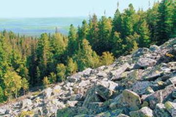
On the flat tops of mountains in a zone devoid of vegetation, as well as on the interfluves of plateaus and plateaus, as a result of active physical (temperature and frost) weathering, rubble-block stone seas
.
Solifluction
 Solifluction is the flow of waterlogged soil during its seasonal thawing. Such soil, even on small slopes of the terrain, sometimes reaching only a fraction of a degree, can spread.
Seasonal freezing and thawing of soils also occur outside the permafrost zone, leading to the same phenomena under conditions of waterlogging and at a certain slope of the surface. V mountainous areas as a result of solifluction processes drip terraces, curums and stone streams, structural soils and upland terraces.
Indented terrace(mudslides) have the shape of a small tongue, ranging from several meters to hundreds of meters, with a steep cliff at the bottom. When the layers slip, the layers are crumpled and often ruptured.
Kurums and stone streams(stone rivers, stone seas) represent clusters of acute-angled boulders of various sizes. Their movement is carried out down the slope due to the sliding of boulders on the moistened and frozen crushed stone litter. Similar landforms are also found outside the permafrost zone. They may indicate climate change that has occurred.
Upland terraces are formed in high-mountainous areas on the slopes of mountains. They arise at various levels of solitary mountains, and this distinguishes them from river, lake and sea terraces. Outwardly, such terraces are relatively flat surfaces bounded by ledges. According to S.V. Obruchev, they are formed as a result of solifluction processes. According to S.G. Boch and I.I. Krasnov, upland terraces arise as a result of snow-frost weathering along the edge of the snowfield.
Thawing niches (thermokarst)
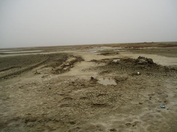
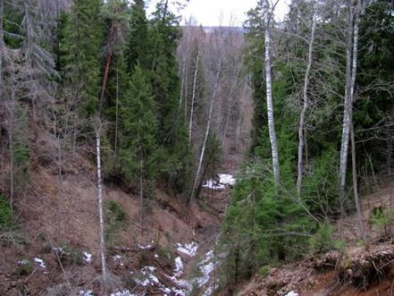
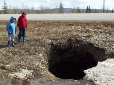 Thermokarst- the phenomenon of the formation of karst sinkholes as a result of thawing of the active layer, permafrost and subsidence of the soil. In most cases, local fires contribute to this.
This process is formed by thawing underground ice, which can be associated with climate warming, leading to the degradation of permafrost, or with local causes, such as the warming effect of water bodies, large fires, human economic activities, etc. Thermokarst landforms are of subsidence origin: the earth's surface subsides over the formed underground cavities.
The morphological manifestation of thermokarst depends on the total ice content of frozen strata and the form of occurrence of underground ice. In addition, the thermokarst relief in most cases is complicated by concomitant processes: solifluction, erosion. Depending on the appearance and size, they are distinguished thermokarst saucers, funnels, dips, hollows, lake baths, hollows and other hollow shapes.
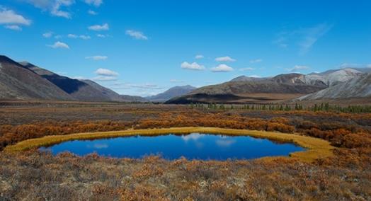
Subsequently, such thermokarst is often filled with water, forming thermokarst lakes characteristic of the tundra zone.
 |
 |
|
Development scheme of thermokarst lakes in the tundra part of the North |
|
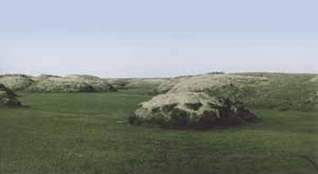
Rounded lakes are thermokarst basins flooded with water. Such hollows and hollows occur when underground ice melts and the surface subsides. This happens if the soil contains a lot of ice. This condition 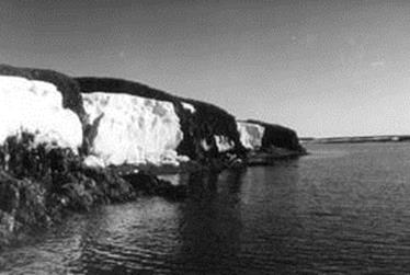 the answer is loose rocks lying on plains or in hollows, where water would accumulate in a warm climate.
There are many reasons for the appearance of thermokarst depressions: climate warming, flattening of vegetation, disturbance of the upper layers of the soil by transport and during grazing of deer. They are also formed during the usual summer thawing of soils. It is enough to form a small reservoir, as its water begins to transfer its heat to the frozen rocks, the thawing of underground ice intensifies, the lake grows until the water leaves or a sufficiently thick layer of lake sediments accumulates at the bottom, isolating the ice from the water.
The emergence of permafrost on the banks of the Yakutia River
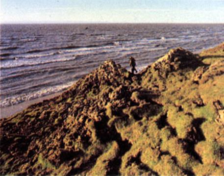
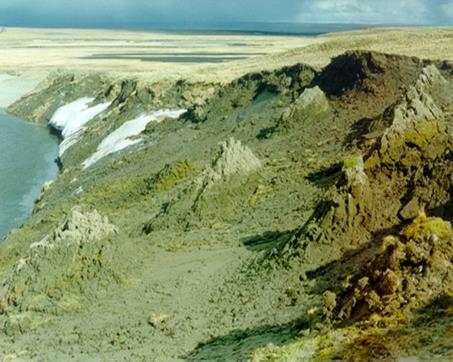
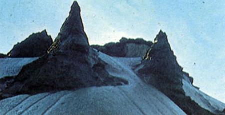
Drained thermokarst basins - alases - are covered with meadow vegetation and are the best pastures in the tundra. Thermal erosion and thermal abrasion. In areas with permafrost, the rapid growth of potholes, hollows, ravines is facilitated by flowing water. It acts on the surface both mechanically - tearing off and carrying away soil particles, and thermally - melting permafrost (thermal erosion). Permafrost-folded sea coasts are easily destroyed. Thanks to this phenomenon - thermal abrasion - the shores of many Arctic seas recede, small islands disappear.
Erosion in permafrost usually has a significant thermal component (hence the term thermal erosion). Due to the thermal effect of flowing water on the frozen bottom and banks, erosion potholes and ravines often grow very quickly. Erosion forms are laid along the cracks in polygonal soils and along thermokarst depressions. After the ice wedges melt, the resulting ditches rapidly expand with water, turning into ravines, while the central parts of the polygons remain in the form of small hills several meters high. Such hills are known under the Yakut name. bayjarahi.
 |
 |
 |
 |
|
Bayjarahi |
|
Thus, the noted temperature-deformation phenomena in the active and permafrost layers of the soil largely depend on changes in external factors introduced by humans during the development of a given territory.
Permafrost in Russia and modern glaciation
 Modern glaciers occupy a small area on the territory of Russia, only about 60 thousand km 2, but they contain large reserves of fresh water. They are one of the sources of river feeding, the importance of which is especially great in the annual flow of the rivers of the Caucasus.
Main area modern glaciation(more than 56 thousand km 2) is located on the Arctic islands, which is explained by their position in high latitudes, which determines the formation of a cold climate.
The lower border of the nival zone drops here almost to sea level. Glaciation is concentrated mainly in the western and central regions where more precipitation falls. The islands are characterized by cover and mountain-cover (mesh) glaciation, represented by ice sheets and domes with outlet glaciers. The most extensive ice sheet is located on the Northern Island of Novaya Zemlya. Its length along the watershed is 413 km, and its maximum width reaches 95 km.
Moving eastward, most of the islands remain ice-free. Thus, the islands of the Franz Josef Land archipelago are almost entirely covered with glaciers, on the New Siberian Islands glaciation is typical only for the northernmost group of De Long islands, and on Wrangel Island there is no blanket glaciation - there are only snowflakes and small glaciers.
The thickness of the ice sheets of the Arctic islands reaches 100-300 m, and the water reserve in them is approaching 15 thousand km 2, which is almost four times more annual flow all rivers of Russia.
Glaciation of the mountainous regions of Russia, both in area and in volume of ice, is significantly inferior to the ice sheet of the Arctic islands. Mountain glaciation is characteristic of the highest mountains of the country - the Caucasus, Altai, Kamchatka, the mountains of the North-East, but it also occurs in low mountain ranges of the northern part of the territory, where the snow border lies low (Khibiny, northern Urals, Byrranga, Putorana, Kharaulakh mountains ), as well as in the area of Matochkin Shara on the North and South Islands of Novaya Zemlya.
Many mountain glaciers lie below the climatic snow limit, or "level 365", at which snow remains on the horizontal underlying surface for all 365 days of the year. The existence of glaciers below the climatic snow boundary becomes possible due to the concentration of large masses of snow in negative landforms (often in deep ancient crust) leeward slopes as a result of snow drift and avalanches.
The area of mountain glaciation in Russia is slightly more than 3.5 thousand km 2. The most widespread are tar, tar-valley and valley glaciers. Most of the glaciers and glaciers are confined to the slopes of the northern points, which is due not so much to the conditions of snow accumulation, but also to greater shading from the sun's rays (insolation conditions). In terms of the area of glaciation among the mountains of Russia, the Caucasus ranks first (994 km 2). It is followed by Altai (910 km 2) and Kamchatka (874 km 2). Less significant glaciation is characteristic of the Koryak Upland, the Suntar-Khayata and Chersky ridges. Glaciation in other mountainous regions is not great. The largest glaciers in Russia are the Bogdanovich glacier (area 37.8 km 2, length 17.1 km) in the Klyuchevskoy group of volcanoes in Kamchatka and the Bezengi glacier (area 36.2 km 2, length 17.6 km) in the Terek basin in the Caucasus.
Glaciers are sensitive to climate fluctuations. In the XVIII - early XIX centuries a period of general reduction of glaciers began, which continues to this day.
The internal waters of Russia are represented not only by accumulations of liquid water, but also water in a solid state, which forms the modern cover, mountain and underground glaciation. The area of underground glaciation is called permafrost (the term was introduced in 1955 by the Soviet permafrost scientist PF Shvetsov; earlier the term “permafrost” was used to designate it).
 Cryolithozone - the upper layer of the earth's crust, characterized by negative temperatures of rocks and the presence (or the possibility of existence) of underground ice. It includes permafrost rocks, underground ice and non-freezing horizons of highly mineralized underground waters.
Cryolithozone (from the Greek kryos - cold, frost, ice, lithos - stone and zone - belt * a. cryolitic zone, cryolithozone; n. Frostboden; f. zone de cryolithe; and. zona de criolitas) - part of the cryosphere, which is the upper layer of the earth's crust, characterized by negative. temperature of soils and forges. rocks and the presence or possibility of the existence of underground ice.
The term was proposed by P.F.Shvetsov in 1955. K. includes frozen rocks, frosty rocks and chilled rocks. Chilled rocks are saline or saturated salt waters and brines with temperatures below 0 ° C (Cryohaline waters).
By the time of its existence, the permafrost zone is distinguished for perennial (from several years to thousands of years) and seasonal (areas of seasonal freezing of rocks). The perennial permafrost zone is subdivided into subaerial land, subglacial under glaciers, and submarine under the waters of seas and oceans.
The subaerial permafrost zone approximately coincides in area with the permafrost zone, in which permafrost rocks (permafrost) are developed, occupying 25% of the land and spread over almost 1/2 of the territory. CCCP. This amounts to approx. 10-10.7 million km 2.
The distribution from the permafrost surface, the distribution of the average annual temperature of rocks at the base of the layer of their annual fluctuations obey geocryological. zonality and altitudinal zonality. Near the south. the permafrost boundaries have a sparsely insular distribution, the northern one is insular, massively insular, discontinuous and continuous. At the same time, permafrost occupies an area of up to 10% with a frozen stratum thickness (MMT) of up to 10-15 m; from 10 to 30% (at MMT up to 25-30 m); from 30 to 80% (at MMT up to 50 m); from 80 to 95% (at MMT up to 150 m) and more than 95% (permafrost thickness up to 1500 m and more). From south to north (while in mountains the area of distribution decreases with height), the average temperatures of frozen rocks decrease, the depth of seasonal freezing on taliks decreases, and the nature of cryogenic processes and phenomena changes.
The subaerial permafrost zone is subdivided into 2 permafrost. zones - northern (continuous) and southern (insular and discontinuous) permafrost propagation. 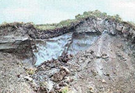 Within the sowing. geocryological the permafrost zone has a large thickness (up to 1500 m), mainly. Pleistocene age and vertical continuous structure. Only hydrogenic and hydrogeogenic types of taliks are developed here, the existence of which is due to the thermal effect of reservoirs, streams and groundwater. High ice epicryogenic (marine, ice-sea) and syncryogenic sediments of decomp. genesis c syngenetic. wedge ice (including ice complex).
For the south. geocryological zones are characteristic preim. The permafrost is of the Upper Holocene age, the thickness of which on the plains increases from 3 to 5 to 100 m and more from south to north. All categories of taliks are developed within it, and radiation-thermal taliks determine the character of IMF propagation from the surface. B south. zone occurs periodically. disconnection top. permafrost surface from the seasonally freezing layer (the formation of non-melting permafrost) and the emergence of thin frozen strata and “overflights” on taliks.
Ha C. East European, West Siberian plains and, possibly, on the Central Siberian plateau, relict Pleistocene permafrost are widespread, occurring at a depth of from the first tens to 200 m and more and having a thickness from the first tens to 500 m. Upper Holocene permafrost, there is a two-layer permafrost. In the mountains Yuzh. Siberia, in the Altai highlands, Cp. Asia and others. The presence of permafrost is due to the altitudinal zonation. In Altai, the islands of the MMP start at heights. 2000-3000, in the Tien Shan -2000-2500, in the Caucasus - approx. 2500 m. The permafrost continuity increases with height, cp. the temperature drops to -15 ° C and below, and their thickness on some ridges increases to 2000 m and more. Ha high. more than 5 thousand m permafrost in summer can only thaw for a short time (during the day) from the surface on the southern slopes. In the vertical section, the permafrost zone consists of one or several. layers of frozen, frosty and chilled rocks
In the conditions of a long cold winter with a relatively small thickness of the snow cover, the rocks lose a lot of heat and freeze to a considerable depth, turning into a solid frozen mass. In summer, they do not have time to completely thaw, and negative ground temperatures persist even at shallow depths for hundreds and thousands of years. This is facilitated by the huge reserves of cold that accumulate over the winter in areas with negative average annual temperatures. So, in the Middle and North Eastern Siberia the sum of negative temperatures for the period of snow cover is -3000 ... -6000 ° С, and in summer the sum of active temperatures is only 300-2000 ° С.
Rocks that have been at temperatures below 0 ° C for a long time (from several years to many millennia) and cemented by moisture frozen in them are called permafrost. Ice content, i.e. the ice content of permafrost can be very different. It ranges from a few percent to 90% of the total breed. In mountainous areas there is usually little ice, but on the plains, underground ice often turns out to be the main rock. Especially a lot of ice inclusions are contained in clay and loamy deposits of the extreme northern regions of Central and North-Eastern Siberia (on average from 40-50% to 60-70%), which differ in the lowest constant soil temperature. 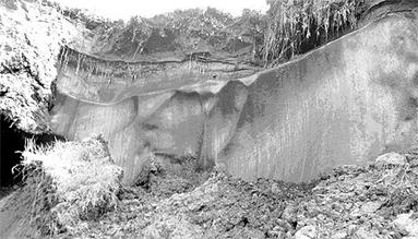
Permafrost - unusual phenomenon nature, which was noticed by explorers in the 17th century. It was mentioned in his works by V.N. Tatishchev ( early XVIII v.). The first scientific studies of permafrost were carried out by A. Middendorf (mid-19th century) during his expedition to the north and east of Siberia. Middendorf was the first to measure the temperature of the permafrost layer at a number of points, established its thickness in the northern regions, made assumptions about the origin of permafrost and the reasons for its widespread distribution in Siberia.
In the second half of the XIX century. and the beginning of the XX century. permafrost was studied along with prospecting work by geologists and mining engineers. In the Soviet years, serious special studies of permafrost were carried out by M.I. Sumgin, P.F. Shvetsov, A.I. Popov, I. Ya. Baranov and many other scientists.
The permafrost area in Russia occupies about 11 million km 2, which is almost 65% of the country's territory.
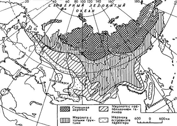
Permafrost distribution over the territory of Russia
Its southern border runs along the central part of the Kola Peninsula, crosses the East European Plain near the Arctic Circle, deviates southward along the Urals to almost 60 ° N, and along the Ob - to the north to the mouth of the Northern Sosva, then runs along the southern slope of the Siberian Uvalov to the Yenisei in the Podkamennaya Tunguska area. Here the border turns sharply to the south, runs along the Yenisei, goes along the slopes of the Western Sayan, Tuva and Altai to the border with Kazakhstan.
In the Far East, the permafrost boundary runs from the Amur to the mouth of the Selemdzha (left tributary of the Zeya), then along the foot of the mountains on the left bank of the Amur to its mouth. There is no permafrost on Sakhalin and in the coastal areas of the southern half of Kamchatka. Permafrost spots are found south of the border of its distribution in the Sikhote-Alin mountains and in the high mountains of the Caucasus.
Within this vast territory, the conditions for the development of permafrost are not the same. The northern and northeastern regions of Siberia, the islands of the Asian sector of the Arctic and the northern island of Novaya Zemlya are occupied by continuous low-temperature permafrost. Its southern border runs through the northern part of Yamal, the Gydan Peninsula to Dudinka on Elisey, then to the mouth of the Vilyui, crosses the upper reaches of the Indigirka and Kolyma and goes to the coast of the Bering Sea south of Anadyr. To the north of this line, the temperature of the permafrost layer is -6 ... -12 ° C, and its thickness reaches 300-600 m and more. To the south and west, permafrost with islands of taliks (thawed ground) is widespread. The temperature of the permafrost layer is higher here (-2 ... -6 ° С), and the thickness decreases to 50-300 m. Near the southwestern edge of the permafrost area, there are only isolated spots (islands) of permafrost among the thawed ground. The temperature of the frozen ground is close to 0 ° С, and the thickness is less than 25-50 m. This is insular permafrost.
In the frozen mass, large reserves of water are concentrated in the form of underground ice. Some of them were formed simultaneously with the enclosing rocks (syngenetic ice), others - during the freezing of water in previously accumulated strata (epigenetic).
The large thickness of the permafrost, the finds of well-preserved mammoths in it indicate that the permafrost - a product of a very long-term accumulation of cold in rock strata. The overwhelming majority of researchers consider it to be a relic of the ice ages. The modern climate in most of the permafrost distribution area only contributes to its preservation, therefore the slightest violation of the natural balance leads to its degradation. This must be taken into account in the economic use of the territory within which the permafrost is widespread.
Permafrost affects not only groundwater, the regime and feeding of rivers, the spread of lakes and swamps, but also many other components of nature (relief, soil, vegetation), as well as economic activity person. When developing minerals, laying roads, building, during agricultural work, it is necessary to carefully study the frozen soil and prevent its degradation.
Permafrost types and processes caused by permafrost in Russia
As already noted, about 65% of the territory of Russia has permafrost, therefore, the construction of structures in such conditions is an urgent problem.
The term permafrost should be represented in a time period of the order of several hundred years or more, and in general, in accordance with the period of permafrost existence, the following structures should be considered:
- Permafrost soils that have existed for centuries and thousands of years.
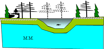
- Permafrost (mm), existence for years, tens of years.
- Seasonal permafrost, existence of hours, days.
Continuous permafrost
This type of permafrost is found in the far north of Russia. The scheme of the existence of continuous permafrost with the main accepted designations is presented in the scheme:
 |
 |
| Scheme of the existence of continuous permafrost with the main accepted designations |
Layered permafrost (degradation of continuous permafrost)
This type of permafrost occurs in some places and does not have a clear theory of its origin. One of the theories assumes that this type
occurred as a result of the degradation of continuous permafrost.
It is possible that a tectonic crack has arisen, along which water (heat) passed, and thawed a layer of soil with a higher thermal conductivity.
It is interesting to note that for a long time, researchers have raised the question of the thickness of the permafrost layer. So in 1827 in Yakutsk, the Russian merchant Fyodor Shergin (an employee of the Russian-American Company) decided to dig in the frozen soil for a well and get water. He subsequently made a bet. Having developed about 100 m, the frozen ground was not passed. As a result, Fedor Shergin practically went bankrupt. The Russian Academy of Sciences became interested in this and allocated money to continue the work - this money was enough for about 15 m of tunneling. Thus, a well with a depth of H = 116.4 m was dug in 16 years. This well is called "Sherginskaya mine" and is still located almost in the center of Yakutsk. Subsequently, this mine served as an object for research work. Thermal calculations were used to determine the thickness of the permafrost layer in this place, which was approximately 500 m.
Island permafrost
This type of permafrost with dimensions in plan from tens to several hundred meters and a depth of up to 10 meters or more is found in the Siberian region (northern part of the Krasnoyarsk Territory, Irkutsk, Chita regions).
 |
 |
| Scheme of the existence of insular permafrost against the background of thawed soil |
It is often difficult to accurately determine the location of such permafrost by geological surveys. Not taking into account (not certain position) of this permafrost can cause significant difficulties in the construction of structures in these areas. It is necessary to carry out more accurate (detailed) geological exploration.
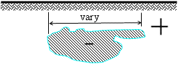
Lens permafrost
The insidiousness of this type of permafrost, found in the southern regions of Siberia, is clearly shown in Scheme 4. The dimensions of such permafrost in the plan can be tens of meters, and the thickness does not exceed several meters. Such lenses against the background of thawed ground are dangerous because they are very difficult to identify. If, during the construction of the building, the lens was not determined, and the building at least partially covers the lens, then during operation the heat fluxes from the building will cause degradation (thawing) of the lens, which will provoke unpredictable uneven precipitation.
If you follow the change in permafrost in Siberia from North to South, then you can consistently meet all the listed types of permafrost. However, lens permafrost can also form “artificially” in the built-up areas, provided that heat transfer between the soil surface and the atmosphere is disturbed.
So, for example, back in the city of Irkutsk in 1925, cases of the formation of lenses of frozen soil were recorded. The construction of the building here began in 1917 and then mothballed for 8 years. As a result, a lens of frozen soil formed under the building, which, after the building began to operate, began to melt, which led to uneven precipitation and an emergency in the building. Similar phenomena were found in Bratsk and Shelekhov (Irkutsk Oblast).
It is necessary to present the results of the experiment, which was staged in Bratsk (Roshchin V.V.) (see Scheme 5). A canopy measuring 11 m by 24 m was built above the surface of the soil (such a structure, due to the impossibility of getting sunlight on the ground, disrupted the natural heat exchange at the base).
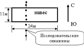
Scheme of a research site for studying the conditions of artificial formation of a lens in frozen soil
Research wells were drilled across the canopy from north to south to determine the depth of freezing (thawing) of the soil. Observations have shown the development of the following process:
- After 1 year of the canopy's existence, the thawing of the soil ended by the end of September.
- After 2 years of the canopy's existence, the thawing of the soil ended by the end of November.
- After 3 years of the canopy's existence, the soil did not thaw, since a lens of frozen soil formed under the canopy.
Thus, these studies have clearly shown how sensitive the natural environment is to external influences.
If we drill a well in frozen soil, then we will see the following picture (see diagram 6) changes in soil temperature over depth (z)
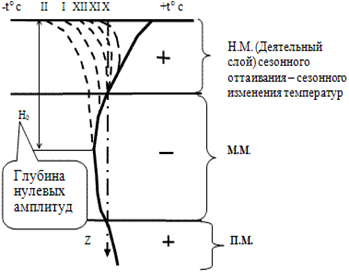 Scheme of seasonal changes in the temperature of active and permafrost soils along the depth of the base in different periods of time
During the summer period, the suprapermafrost layer of the soil (active layer) will have a positive temperature, i.e. will be in a thawed state. With the beginning of the winter period, when the temperature of the air and the soil surface drops to a negative value, the suprapermafrost layer of the soil will begin to freeze.
Annual changes in the temperature amplitude of this layer along the depth of the base will reach the value H 0, below which the soil will be practically at a constant negative temperature of ≈ -4 ° C (permafrost).
With a cyclical action of negative and positive temperature on the ground, in the last three stages are possible:
- Freezing.
- Frozen state.
- Thawing.
Annual thawing and freezing of the active soil layer
Freezing of the active layer in the winter period may not occur to the entire depth, in this case they speak of non-melting permafrost, since there will be an interlayer of thawed soil between the active layer and permafrost.
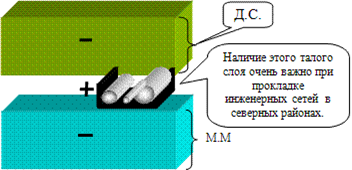 Diagram of a non-draining active soil layer and the possibility of laying engineering communications in these conditions
The presence of an interlayer of thawed soil with a non-merging active layer is important from the point of view of the possibility of laying utilities in this layer. Engineering networks laid in a thawed layer of soil will not experience deformations associated with freezing and thawing and therefore are economically profitable.
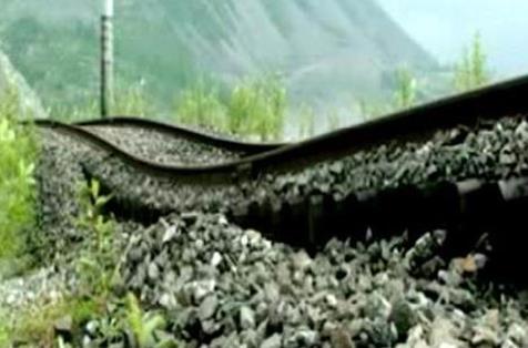
In the process of freezing and thawing, soil deformations can occur, which reach 20 ... 30% and more. Freezing water increases by only ≈ 9%, however, under natural conditions, this phenomenon is explained by moisture migration (movement of ground water from the underlying thawed layers to the freezing front), which is largely manifested in clay soils. This phenomenon leads to frost heaving of soils.
Heaving of soils during freezing
It should be noted that this is a very important problem, with the resolution of which builders are very often encountered not only in areas of permafrost soil, but also in areas of deep seasonal freezing. Therefore, this should be discussed separately.
It should be mentioned that for the first time the builders met with this issue during the construction of railways in the north of Russia (Siberia). With a merging active layer, the swelling of clay soils, due to the migration of moisture from the underlying still thawed layers to the freezing front, leads to dehydration of the underlying layer.
![]() Diagram of the merging active layer and the development of the phenomenon of soil heaving in it
Diagram of the merging active layer and the development of the phenomenon of soil heaving in it
If we denote: h is tuberous. - the amount of soil heaving; H pr. Is the thickness of the freezing active layer (DS), then the active heaving zone (H act) (see the diagram in the diagram) will be numerically: H act ≈ 2/3 N pr.
This phenomenon is of great importance, since it allows you to place engineering networks in a dehydrated - not heaving layer (lower 1/3 N etc.), without fear of their deformation.
Sediment during thawing of the active soil layer
When freezing, the soil freezes with the surfaces of the foundations, and then, when heaving, deforms them. This often leads to displacement of foundations. Subsequently, during thawing, the soil loses its strength properties, the compressibility increases significantly (subsidence occurs). It is also possible for such a soil to flood out from under the base of the foundation (loss of stability - failure to fulfill the conditions of the first limiting state).
Ice formation
In the North, one could often see such a picture when ice suddenly appeared under the exploited houses. 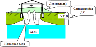
Scheme of the most probable formation of ice with a merging active layer and a high level groundwater
This is explained by the fact that the depth of freezing under the house with the merging active layer (DS) is much less (thermal effect of the building) than on the open surface. This leads to the formation of pressurized waters (with a high U.G.V. and a merging active layer), which can break through and, flowing out through windows and doors, freezing on the surface, form ice.
Ice formed during the period of freezing of the active layer is especially harmful to roads.
When the active layer freezes (merging permafrost), the soil, first of all, freezes under the road (the influence of ditches). The rest of the active layer will be in the freezing stage. As a result, there is a movement of pressure water along the slope and it is possible for them to break through to the surface with the formation of ice.
The most effective use of special measures, i.e. artificial creation conditions conducive to faster freezing of the soil in the place we need. Clearing of surfaces from snow, removal of vegetation layer, etc. is used. As a result, under the cleared area there is a rapid freezing and merging of the active layer with permafrost. This measure stops the movement of pressurized water towards the road and if ice formation occurs, then in this place it does not have a negative impact on the operated road.
Slope current. Solifluction phenomenon
The phenomenon of solifluction or the course of a slope as a result of freezing and thawing processes.
Solifluction(Latin solum - soil and fluctio - outflow) - runoff of soil, oversaturated with water, over the frozen surface of the ice-cemented base of the slopes. Solifluction is observed in different natural areas... The phenomenon is widespread in zones with permafrost or deep and long-term freezing soils (tundra, forest-tundra, Central and Eastern Siberia, Canada, highlands). The fine-earth soil cover is saturated with moisture from melting snow or rains, becomes heavier, becomes viscoplastic and begins to move even at slopes of 2-3 ° along the slippery surface of the frozen underlying layer that has not yet thawed, accelerating as the slopes increase from several centimeters to a meter per year. At the same time, scalloped floods, low ridges and whole solifluction terraces appear on the slopes, even on slopes with stands (mainly larch), forming a drunken forest.
There are two types of cryogenic landslides:
1. cryogenic sliding landslides - the displacement of thawed rocks of the seasonally thawed layer (STL) along the frozen-thawed interface;
2. Cryogenic landslides of the current (fast solifluction) - the process of liquefaction of rocks of the seasonally thawed layer (STL) and their viscous / viscoplastic flow over the surface of permafrost (permafrost).
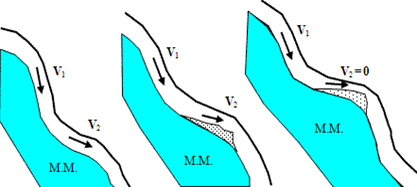
If we take point A on the surface of the slope of the active layer, then during freezing as a result of heaving, it will move to point B. Then, during thawing under the action of gravitational forces, point B will drop and will be in the position of point C. Thus, as a result of seasonal temperature changes, point A will eventually move to point C, i.e. possible gradual sliding of the slope.
Even the same slope can have surface areas with different slopes. In this case, the steeper slope sections will have a higher creep rate (V 1) compared to the speed (V 2) on the flatter sections. As a result, in areas with a lower flow rate of the slope, soil particles will gradually accumulate, up to a complete stop (horizontal area with V 2 = 0).
 |
 |
|
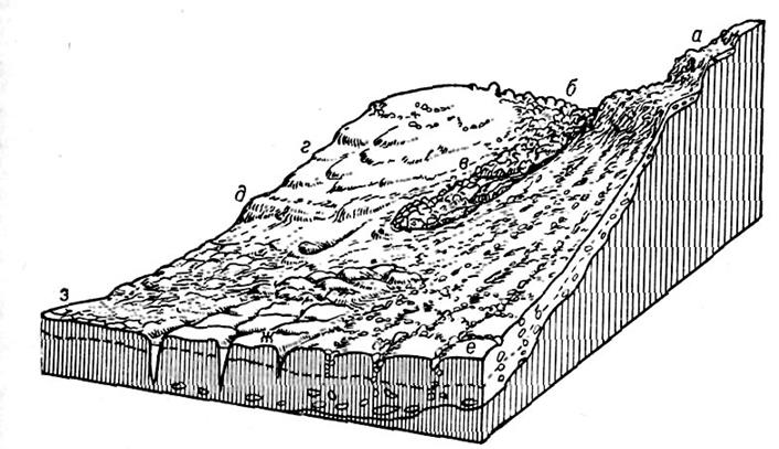
Permafrost-morphological formations: a - upland terraces; b - curum; c - stone river; d - solifluction (drip) terraces; d - solifluction shaft; e - cellular forms of structural soils; g - fissured frost polygons; h - polygonal soils |
Diagram of the development of an uneven slope flow process in an active soil layer |
Thus, a kind of "waves of the slope relief" are formed, going up, while the soliflucation layer flows down.
 |
 |
| The steep slopes of the Kvarkush plateau (Krasnovishersky district of the Perm Territory) and the alternation of freezing - thawing seasons provoke the formation of stone talus (curums) and flat soil flow (solifluction) | Fossil underground ice outcrop on the Arctic coast of Yakutia |
Temperature change in the upper layers of permafrost soils
Below the depth H 0 - the amplitude of zero temperatures, the permafrost soil will be at a constant negative temperature of ≈ -4 ° C. Such a constant temperature is ensured practically at a depth of ≈15 m (depth of zero amplitudes).
The frozen ground is actually a solid body. The strength (R) of frozen soil is almost linearly dependent on its temperature R = f (t ° C). When the temperature of the upper layers changes, the strength will also change, the higher the temperature, the lower the strength.
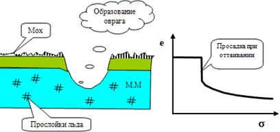
Subsidence during thawing of a layer of permafrost soil
This phenomenon is a kind of scourge for builders. When permafrost soil thaws, the strength characteristics of the soil drop sharply, this phenomenon must be taken into account when constructing buildings in such places.
In one of the villages northern expedition the following phenomenon was noticed. They laid a road, but as soon as the all-terrain vehicle passed through one place several times, a ravine formed in this place. The all-terrain vehicle, in its movement with caterpillars, tore off the surface layer of moss. The soil was bare and began to thaw under the influence of sunlight. Moss played the role of thermal insulation, and since there was ice in the frozen soil layer, during thawing, this entailed subsidence - an avalanche-like development of deformations (see graph e = e (s)) under its own weight (formation of a ravine).
 |
 |
|
Diagram of the development of the process of subsidence of a thawing base with a characteristic compression dependence |
|
In the laboratory of permafrost studies at the Igarskaya scientific research station, such a peculiar experiment was carried out (Dalmatov BN). The laboratory room is made directly in frozen ground. Light from one laboratory penetrated through a two-meter thickness into another laboratory, creating some illumination at the same time. The light penetrated through layers of ice, individual inclusions of which were 20 cm thick.
There is no doubt that when thawing, such soil will have subsidence properties. When designing buildings on such soils, it is necessary to use the "Guidelines for calculating the settlement of thawed and thawed soils in time" (1967-1976, Research Institute of Bases and Foundations).
Formation of frost cracks in active and permafrost soil layers
When ground surfaces bare from snow freeze (a sharp drop in temperature), its volumetric decrease occurs, often accompanying the formation of wedge-shaped cracks (cracks). The depths of these cracks - cracks reach several meters, and the opening width is 10 ... 15 cm. Frost cracks cross not only the active layer, but also penetrate into permafrost. Over time, water penetrates into the cracks, which then turns into ice, and this contributes to the further growth of the formed frost crack.
Such frost cracks lead to a change in the depth of frost penetration. They can cause damage to the roadbed, buildings, engineering networks.
Permafrost and modern climate
 At the end of the 20th century, the problem of climate change towards global warming became one of the central problems of concern to the world community. Most climatologists associate the increase in air temperature with the ever-increasing industrial emissions of carbon dioxide, methane, and other gases that cause the greenhouse effect. More recently, just a few years ago, a number of major climatologists predicted an increase in air temperature in the North at the beginning of the 21st century by 10-15 degrees Celsius. Ufologist A.K. Priima even predicted that with such a sharp warming of the climate, a third of humanity could die from droughts and disasters.
Analysis of meteorological data for a number of countries of the Northern Hemisphere (Russia, Canada, USA-Alaska, China) confirms that in the last 25-30 years the climate has indeed been warming, albeit more moderate. The increase in air temperature over this period in most regions of Russia is 1-1.2 degrees Celsius. According to the American Geophysical Union, between 1991 and 1997, the global air temperature rose by 0.62 degrees Celsius. In the last 3-4 years, every Russian in the middle zone of our country could feel the warming of the climate: here are hot and dry summer seasons and mild winters followed each other.
Climate warming leads, in turn, to the thawing of permafrost and the release of gases (especially methane) buried in the permafrost, and their additional entry into the atmosphere. It is no coincidence that warning headlines have appeared in newspaper reports in recent years: "Methane Bomb in Permafrost." Numerous studies on the problem of global warming have been and are being carried out within the framework of thematic plans of institutes, state and international programs.
The economic importance of the permafrost area, or permafrost zone, as it is called by permafrost scientists, is difficult to overestimate. This is the strategic rear of the Russian economy, its fuel and energy base and currency shop. The northern edge of the country is extremely sparsely populated. In the vast expanses of arctic cold deserts, tundra, forest-tundra, taiga and mountain steppes, on plains, plateaus and mountains, there is less than one person per square kilometer. In the Yamalo-Nenets National District, this figure is 0.6 people. per sq. km, in Koryakia and Chukotka - 0.1-0.2, and in Evenkia and Taimyr and at all 0.03-0.06.
Nevertheless, we must not forget that within the permafrost zone of Russia, more than 30% of the explored reserves of all oil in the country, about 60% of natural gas, innumerable deposits are concentrated. coal and peat, most of the hydropower resources, reserves of non-ferrous metals, gold and diamonds, huge reserves of timber and fresh water. A significant part of these natural resources is already involved in economic circulation. An expensive and vulnerable infrastructure has been created: oil and gas production facilities, trunk oil and gas pipelines thousands of kilometers long, mines and quarries, hydroelectric power plants, cities and towns have been erected, roads and railways, airfields and ports have been built. Magadan, Anadyr, Yakutsk, Mirny, Norilsk, Igarka, Nadym, Vorkuta are located on the permafrost, even within the borders of Chita there are islands of permafrost. At present, methods for predicting the consequences of the construction of buildings and structures on permafrost are well developed. However, it is not only human activities that change the permafrost conditions. On a much larger scale, unpredictable climate changes affect the frozen strata.
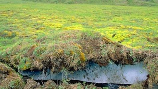
Progressive thawing of frozen rocks can have catastrophic consequences. The fact is that the upper horizons of permafrost rocks with a thickness of 2-5 to 30-50 m and more contain ice in the form of small lenses and veins, as well as large deposits in the form of a wedge-shaped lattice (polygonal in plan) or stratal deposits with a thickness of up to 30 40 m. In some parts of the northern plains, ice accounts for up to 90% of the volume of frozen rocks.
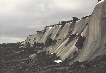
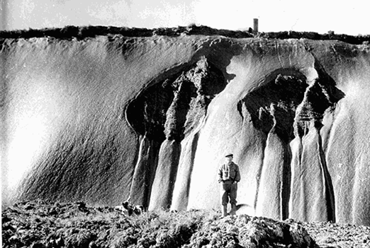 Large ice veins in permafrost. Kular ridge, Northern Yakutia
Thawing of ice-saturated rocks will be accompanied by subsidence of the earth's surface and the development of dangerous permafrost (cryogenic) geological processes: thermokarst, thermal erosion, solifluction, etc. Whole regions with low absolute surface elevations will be flooded by the sea. There will be a threat of destruction of buildings and engineering structures erected with the preservation of the frozen foundation. Such consequences of climate warming will be devastating for the economy.
Permafrost scientists are able to quantitatively assess the coming changes in permafrost for any period of time and prevent many of their harmful consequences, minimize the costs of stabilizing the permafrost environment, but only if the initial climatic parameters are reliably known. The catch is that climate forecasts are far from perfect, due to the complex nature of changes in weather and climate. The climate is constantly undergoing natural changes. In 1625 Sir Francis Bacon drew attention to the fact that in addition to daily and seasonal changes in meteorological elements, there are also numerous long-term cycles of their change.
In 1957, J.C. Charlesworth already counted about 150 cycles of climate fluctuations of varying duration. A.S. Monin and Yu.A. Shishkov distinguish billion-year cycles, cycles lasting hundreds and tens of millions of years and smaller (in the historical-geological understanding) fluctuations with a period from tens of thousands to tens of years. The short-period fluctuations of meteorological elements are well-known: 9-14-year, 5-6-year, etc. All different-period cycles of climate and weather change are superimposed on each other and create a complex integral course of changes in meteorological elements. In the last two to three decades, directional changes associated with technogenesis have become more and more noticeably superimposed on natural climatic cycles.
Unfortunately, the reliability and accuracy of long-term meteorological forecasts still leave much to be desired. As a result, the results of climate forecasts are contradictory, which, in turn, causes ambiguity in permafrost forecasts. There are different scenarios of significant climate warming in the permafrost region in the 21st century (M.I.Budyko, O.A. Anisimov, M.K. Gavrilova, F.E. Nelson) and moderate warming (E.P. Borisenkov, A.V. Pavlov), there is even a cooling scenario (N.A. Shpolyanskaya). Scenarios of significant climate warming apply to the permafrost territory only taking into account its most general properties. According to M.K. Gavrilova, by the middle of the coming century, the average annual air temperature in Siberia and the Far East will increase by 4-10 degrees Celsius, as a result of which the permafrost will thaw out and, over time, will remain only in high mountains and on the plains of the north of Eastern Siberia and the Far East. O. A. Anisimov and F. E. Nelson believe that an increase in global air temperature by 2 degrees Celsius will lead to complete thawing of frozen rocks in 15-20% of the permafrost zone. Meteorological data for the last 10-15 years show that extreme scenarios of climate change are not justified, warming is proceeding, but at a more modest pace.
When substantiating the scenarios of moderate climate warming, in addition to the data of meteorological stations, the results of observations at geocryological (permafrost) stations are also used, where, simultaneously with meteorological measurements, the thermal regime of soils, seasonal freezing - thawing and permafrost processes are studied (A.V. Pavlov). This combination increases the reliability of permafrost-climatic forecasts. Let us dwell on this problem in more detail.
Until recently, the network of meteorological stations in the north of Russia was quite extensive; the duration of meteorological measurements in our country reaches 180 years. In addition, by the beginning of 1990, there were about 25 permafrost stations - reference points for monitoring the permafrost zone.
When studying long-term fluctuations of the modern climate, it is necessary to average meteorological data for a number of neighboring years in order to exclude random variations. The most frequently chosen averaging period is 10 years.
Two periods can be distinguished with a pronounced increase in air temperature in the North: from late XIX century to the 1940s of the XX century (this period is called the "warming of the Arctic") and from the mid-late 1960s to the present. The last (modern) warming has not yet reached the size of the "Arctic warming". Moreover, in the early 1990s, a noticeable cooling was observed at a number of Arctic meteorological stations. However, the following years turned out to be warm enough, which was the reason for the continuation of the general trend of climate warming today.
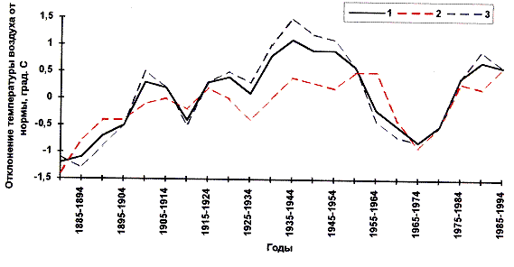
Deviation of 10-year moving averages of average annual (1), average summer (2) and average winter (3) air temperatures from the norm in Salekhard (north Western Siberia)
The rate of increases in the average annual air temperature over the past 25-30 years is 0.02-0.03 degrees Celsius per year in the European North, 0.03-0.07 - in the north of Western Siberia and 0.01-0.08 degrees Celsius a year - in Yakutia. The rise in air temperature itself during this period varies from 0.4 to 1.8 degrees Celsius. Climate warming is mainly due to an increase in winter air temperature.
If the trend towards climatic warming continues in the first half of the 21st century, the average annual air temperature can be expected to increase by 0.9-1.5 degrees Celsius by 2020 and by 2.5-3 degrees Celsius by 2050. Precipitation by the same years they will increase by 5 and 10-15%, respectively.
Analysis of monitoring data and geothermal studies indicates widespread degradation of the upper horizons of the permafrost zone (an increase in the temperature of permafrost, a decrease in their area, an increase in the depth of seasonal thawing) over the past 15-25 years.
As an illustrative example of the ongoing thermal changes in the permafrost zone, we use the observational data of the Marre-Sale station (Western Yamal), located at the site of the meteorological station of the same name. Here, almost at all experimental sites, an increase in the temperature of frozen rocks at a depth of 10 m was recorded in 1979-1998.
It varied from 0.1 to 1 degree Celsius. Only in the strip of surface water runoff (site 34) long-term changes in the temperature of the rocks were practically not observed.
Based on the results of geothermal studies, it was found that the modern warming of rocks reaches depths of tens of meters. An examination of the observational materials of the same station Marre-Sale shows that, despite the large interannual variations in the depth of seasonal thawing, on the whole, there is a weak tendency towards its increase in 1978-1998. The predicted depth of seasonal thawing for 2020 will increase in the North by only 15-20 cm in sands, and even less in sandy loams, clays and peats. Projected regional increases in rock surface temperature will not exceed 1.4 degrees Celsius for 2020 (2025) and 2.3 degrees Celsius for 2050.
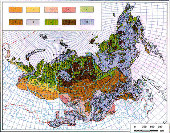 Probable changes in permafrost in Russia during climate warming by 2020 and 2050
The figure shows the evolution of permafrost in Russia in the event that the above forecast estimates of climate warming in the North in the 21st century are justified. 4 zones have been identified, differing in varying degrees and unequal timing of the beginning of the widespread deep thawing of permafrost from above.
For the beginning of deep thawing of frozen rocks, the moment is taken when the layer of soil thawed over the summer does not completely freeze in winter and the roof of the permafrost begins to progressively decrease. The time interval during which the permafrost will completely thaw depends not only on climate warming, but also on the composition and ice content of the rocks, their temperature and thickness, and on the heat inflow from below (from the earth's interior).
Melting can last for years, decades, hundreds and thousands of years.
When compiling a schematic map (see Fig. 3), it was taken into account that permafrost will react differently to the same changes in the global climate in different landscape conditions. The greatest contribution to the diversity of the response of permafrost to atmospheric influences is made by the relief of the earth's surface. The map shows three categories of relief: plains, plateaus, and mountains.
The first zone from the south is the territory where permafrost by 2020 will thaw from above everywhere where it is developed. This zone will form only within the West Siberian Lowland, at the southern limit of the modern permafrost zone. There are rare lens islands of permafrost rocks with temperatures above -0.5 degrees Celsius, confined to peatlands. After their thawing, the southern border of the permafrost zone will retreat to the north by 300 km or more, the melting of peat bogs swollen with ice will be accompanied by intense subsidence of their surface, but this will not bring serious changes to the natural environment and human activity: permafrost peat bogs are rare and are practically not involved in economic activities. ...
The second zone is the territories where permafrost will melt everywhere by 2050. In the north of the European part of Russia, the permafrost zone by this time will retreat in the northern or northeastern direction by 50-100 km, in Western Siberia - by 100-250 km, in the south of the Central Siberian Plateau - by 600 km. In the mountains, changes in the permafrost zone will be minimal: islands of permafrost will thaw everywhere only on the Yenisei Ridge and in a small part of the mountains of Southern Siberia and southeastern Transbaikalia. As in the previous zone, the consequences of the thawing of frozen rocks will be insignificant: islands and small masses of frozen rocks in the most inconvenient for humans tracts - peat bogs, in highly mossy areas of the taiga, on the shaded bottoms of narrow, deep valleys, on the slopes of the northern exposure - will disappear. The modern temperature of these rocks is not lower than -1 degrees Celsius.
The third zone unites territories where by 2050 deep thawing of permafrost will not begin everywhere. The current temperature of permafrost here varies mainly in the range from -1 to -5 degrees Celsius. Only low-ice rocks with temperatures not lower than -1 ... -1.5 degrees Celsius will thaw. These are mainly sands and rocks. The width of the zone of partial thawing of permafrost in the north of the European part of Russia will reach 30-100 km, in the north of Western Siberia - 40-200 km, in Eastern Siberia - 240-820 km.
The zone also includes part of the low mountains of southern Siberia, Transbaikalia, the south of the Far East and Kamchatka up to 60-62 degrees north latitude.
The fourth zone, a zone of relatively stable permafrost, includes the northern part of the permafrost zone with the most low temperatures rocks - from -3 to -16 degrees Celsius. Their power is measured in hundreds of meters. With the predicted scale of climate warming, deep thawing of frozen rocks in this area is excluded. Only the area of taliks will slightly increase.
Thus, on the basis of the above data, one can draw a conclusion about changes in the permafrost zone of Russia by the middle of the XXI century. In 50 years, the temperature of the soil surface will increase by 0.9-2.3 C 0, and the depth of seasonal thawing will increase by 15-33%. As a result, the southern boundary of the permafrost zone on the plains and plateaus will retreat to the north and northeast by 50-600 km. If we add a zone of partial melting to the zones of complete thawing of permafrost, then in general a permafrost degradation zone will form, the width of which in the north of the European part of Russia will reach 50-200 km, in Western Siberia - 800 km and in Eastern Siberia - 1,500 km. The islands and permafrost massifs in the mountains of Transbaikalia, the south of the Far East and Kamchatka will be greatly reduced, but they will not completely disappear.
Negative consequences of climatic warming will be observed throughout the permafrost zone: increased degradation of frozen strata both vertically and horizontally; disruption of the functioning of natural and technical systems, the design of which did not take into account the possibility of global warming and permafrost degradation. In an area where permafrost is relatively stable (the third and fourth zones in Fig. 3), due to the high ice content of the upper horizon of frozen rocks, even a slight increase in the depth of seasonal thawing will lead to the activation of such destructive permafrost processes as thermokarst, thermal erosion and solifluction. The processes of destruction of the coastal ledges of the Arctic seas will intensify. The economy of the North will require additional costs to ensure the safety of the frozen foundations of buildings and engineering structures.
The warming of the climate and permafrost zone expected by the middle of the XXI century is comparable to the warming during the Holocene climatic optimum 4600-8000 years ago, when the southern boundary of the permafrost zone retreated to the north and took a position close to its predicted position in 2050. In territories where permafrost persisted , the depth of seasonal thawing increased. Analysis of the structure of the upper permafrost horizon allows us to establish the depth of seasonal thawing at this time. In the Arctic and alpine regions, it turned out to be 20-40% more than the current depth, that is, comparable to the predicted value of the increase in the thickness of the seasonally thawed layer by 2050. This coincidence once again confirms the reality of the proposed scenario of climate and permafrost warming.
Regional patterns of engineering and geological conditions and zoning Siberian platform
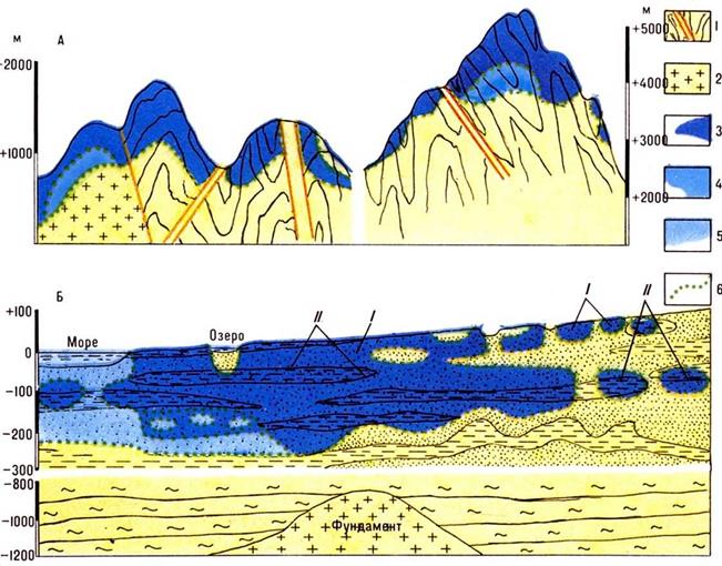
Formation and geological and structural features. Engineering-geological zoning of the Siberian platform is necessary to establish the patterns of spatial variability of engineering-geological conditions on its territory. This task can be successfully solved with strict adherence to the historical and genetic principles of the study and systematization of all factors that determine the engineering and geological conditions of the territory. The regional engineering-geological zoning of the Siberian platform is based on the engineering-geological analysis of rocks and their constituent complexes, the study of the patterns of their distribution in the earth's crust.
The modern engineering-geological appearance of the rocks of this territory was formed under the influence of a complex tectonic regime and climatic conditions throughout all stages of geological development. Based on modern ideas about geological structure The Siberian platform and the laws of its development, it is possible to establish a genetic relationship between the structure, composition, state, physical and mechanical properties of rocks and their complexes, the confinement of these complexes to certain geological structures.
The Siberian platform has a two-tiered structure. The lower structural stage is composed of complex and highly metamorphosed formations of the Archean and Early Proterozoic ages, which form the basement of the platform. They come to the day surface, on the Aldan and Anabar shields and in the Angara-Kan part of the Yenisei ridge. The upper structural layer is composed of rocks from Late Proterozoic to Quaternary age.
Permafrost and hydrogeological conditions. The patterns of distribution and thickness of permafrost mainly depend on the historical, climatic and geological and structural features of the platform. Taking into account the dynamics of changes in geocryological conditions in the Holocene, two geocryological zones can be distinguished on the territory of the Siberian platform: North and South. The boundary of the zones coincides with the boundary of the closure of the Late Holocene and Pleistocene cryogenic strata and is of great engineering and geological significance, since it divides the territory with different modern geocryological characteristics (see Appendix Table 2). At the boundary, the thickness of the cryogenic strata sharply increases, emphasizing its different age. Near the boundary, there is also a transition from continuous to island propagation through the transition zone of discontinuous permafrost propagation. To the south of this line, there are no Pleistocene syngenetic frozen rocks and ice wedges, but thermokarst and pseudomorphoses are widespread.
With all the diversity of the influence of regional and local factors on the territory of the Siberian Platform, a latitudinal-zonal change in the main characteristics of the cryogenic strata can be traced. In the southern regions of the platform, the temperature of frozen rocks varies from 0 to -1 °, and the thickness of the island massifs of frozen rocks - from 3 to 50 m. In the northern regions of the platform, the temperature of rocks decreases to -14 °, and cryogenic strata up to 1500 m and more occur practically everywhere. The areas of taliks here do not exceed a few percent.
Intrazonal heterogeneity of geocryological conditions is determined by the influence of regional and local factors. The most important of the regional factors is the tectonic mobility of individual regions. When assessing the role of neotectonic movements from a geocryological standpoint, special attention should be paid to two aspects: on the one hand, a significant change in the relief, and on the other, the formation and rejuvenation of tectonic faults. Stable uplifts (from 100 to 500 m) are characteristic of most of the Siberian platform and cause a plateau-like dissected relief, the absolute heights of which usually do not exceed the ceiling of the air temperature inversion. Under conditions of winter maximum air pressure, the temperature of rocks increases from the bottoms of the valleys to the watersheds. The altitude gradient of temperature rise is on average 2-3 ° / 100 m.
Only in areas where tectonic uplifts reached 500-1000 m (Putorana plateau, Yenisei ridge, Angara-Lena and Aldan plateau), the relief rises above the ceiling of the air temperature inversion and the latitudinal-zonal regularities in the formation of the main characteristics of the cryogenic strata are violated by the influence of altitudinal-zonal features heat transfer. Here, above the inversion ceiling, an increase in the severity of permafrost conditions with an increase in absolute height terrain. The gradient of lowering the temperature of rocks with height is approximately equal to 0.5-0.7 ° / 100 m.With an increase in height for every 100 m, the thickness of the cryogenic stratum increases by 40-50 m. -15 °, What's on 7-8 ° below the zone-determined ones (Fotiev et al., 1974).
In most of the territory, bedrocks occur practically from the surface. Their cryogenic structure is determined by fracturing, porosity and water content at the beginning of freezing. Strong fracturing, and, consequently, the ice content of the bedrock to a depth of 30-50 m is a characteristic feature Northern zone... Among the cryogenic processes, the most developed are: cryogenic weathering and sorting of soils, slope processes, as well as frost cracking of soils with the formation of ice wedges and primary soil veins. Relative subsidence and accumulation predetermined the geocryological features of the vast Central Yakut lowland. Freezing of thick sandy-argillaceous strata here mainly occurred synchronously with the accumulation of sediments, as a result of which the sediments are characterized by significant ice content due to ice-cement and the wide development of thick (up to 50 m) syngenetic wedge ice. Due to the high ice content of Quaternary sediments and the wide development of repeated ice, thermokarst processes, frost cracking and swelling are widely developed.
The renewal of old and the formation of new tectonic faults significantly affected the dynamics of groundwater and predetermined the peculiarities of the formation of geocryological conditions on the Putorana plateau, along the eastern side of the Predverkhoyansk trough, within the Aldan shield. The specificity of the permafrost geocryological conditions in these regions is a decrease (in comparison with zonal characteristics) in the thickness of permafrost strata, an increase in their discontinuity, and an increase in the temperature of rocks.
In most of the platform, geocryological conditions are closely related to hydrogeological ones. Due to the fact that in the vertical section the hydrochemical and hydrodynamic zones in different hydrogeological structures are replaced in a different sequence, and their thickness varies widely, in the process of cooling the upper horizons of the earth's crust below 0 ° in strict accordance with the environmental conditions, a different the structure of the cryogenic strata. 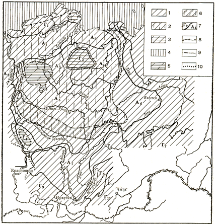
Types of cryogenic strata of the Siberian platform: 1-tier I type; 2-tier II type; 3-bunk type III; 4-II, IV, VI types; 5-II, III, VII and VIII types; 6-subtype "b" of type II cryogenic strata. Borders: 7-hydrological basins of the 1st order; 8-areas of distribution of various types of cryogenic strata; 9-areas of distribution of subtypes of cryogenic strata; 10-areas of permafrost. A-artesian basins with indices 1-8, respectively: Khatangsky, Anabaro-Olenekksiy, Kotuisky, Oleneksky, Tungusky, Yakutsky, Angara-Lensky, West Siberian. G-systems of hydrogeological massifs with indices 1-10, respectively: Taimyr, Khantayskaya, Anabarskaya, Patomo-Vitimskaya, Baikal-Charskaya, Aldanskaya, Verkhoyano-Kolymskaya, East Sayanskaya, Daurskaya
The cryogenic strata of the first type is developed only in the eastern and southern parts platforms, within the boundaries of the Yakutsk and Angara-Lena artesian basins, as well as within the Yenisei and Aldan systems of hydrogeological massifs. Only within the boundaries of these basins, directly under the stratum of permafrost, in the cracks and pores of rocks, there are accumulations of fresh water, predominantly of hydrocarbonate composition for industrial and drinking water supply.
The two-tiered cryogenic strata of the second type occupies the central and northern parts of the Siberian platform, within the boundaries of the Anabar-Oleneksky, Kotuisky, Oleneksky, Tungusky and Yakutsky ( Western part) artesian basins. Within the boundaries of these basins, directly under the stratum of permafrost, in the cracks and pores of rocks, there is an accumulation of saline waters and brines with a negative temperature of predominantly chloride composition. Their mineralization reaches 100-200 g / l, and only in the Anabar-Olenek basin - 20-30 g / l.
Accumulations of fresh waters of hydrocarbonate composition can be found here only within the limits of blind filtration taliks in channels and floodplains. large rivers, as well as under the baths of large non-freezing freshwater lakes.
The two-tiered cryogenic strata of the third type is developed on the territory of the Anabar system of hydrogeological massifs, composed of dense crystalline rocks. Here, frosty rocks lie along the stratum of permafrost, therefore, the accumulations of fresh water are confined exclusively to the rocks of the seasonally thawed layer, as well as to blind filtration taliks under the channels of large rivers.
The complex structure of the cryogenic strata is characterized by the Putorana Plateau. Here, on low watersheds and in valleys, a strata of the second type is developed, and in the high mountain parts of the third, seventh and eighth types, characterized by the predominance of frost rocks in the section, the cracks and pores of which do not contain either water or ice (the map conventionally shows the eighth type cryogenic strata.) In this area, fresh subpermafrost waters are apparently absent altogether.
Cryogenic strata of the fourth and sixth types are confined mainly to low marine terraces and the shelf of the seas of the Arctic Ocean. These types of cryogenic strata are characterized by the predominance in the section of accumulations of negative temperature groundwater of marine origin. In addition to the fourth type shown on the map, the relict, submerged in the sea, cryogenic strata of the second type could have survived in the shallow coastal areas.
The lithology of rocks is also one of the regional factors that significantly affect the conditions for the formation of the geocryological environment. First of all, attention should be paid to the regularities of the distribution of permafrost rocks, carbonate rocks on the territory of the region and to assess the regional conditions for the emergence and development of karst. Karst and artesian basins and artesian slopes of karst-stratal waters are known to be areas of concentration of spring runoff. Therefore, during the entire cooling period, groundwater significantly opposed the conditions of freezing of rocks, causing the formation of a kind of geocryological situation.
Under the influence of the powerful warming effect of karst waters, more heat rocks, significant discontinuity and low thickness of cryogenic strata. An example is the monoclinal karst basins of the periphery of the Siberian platform, especially on the southern slopes of the Yakutsk, Angara-Lensk, and Tunguska artesian basins; in the Aldan folded area, the Yukhtinsko-Ylllymakhsky and Gynamsky karst basins.
Among the local factors influencing the formation of the temperature of rocks and, to a lesser extent, the discontinuity and thickness of cryogenic strata, it is necessary to highlight: the exposure of slopes, snow cover, vegetation, composition and moisture content of Quaternary sediments. They significantly change the zonal value of the temperature of rocks, and therefore it is necessary to carefully study them during engineering-geocryological studies in each region separately. Without this information, it is difficult, and sometimes impossible, to predict changes in the geocryological situation in the process of terrain development.
Construction in permafrost areas
Features of construction in the permafrost zone. Construction of buildings and structures in the south, where the air temperature does not drop below 5 degrees, and construction in Siberia differ. There are many different factors to consider here. Buildings constructed without taking into account permafrost may become unusable after a while. This happens because in summer the earth warms up unevenly by several tens of centimeters. When thawing, the soil becomes wet, sometimes fluid. It settles, creeps. That part of the building, under which the soil softens, subsides. In winter, the soil freezes again, the wet soil swells and the building warps and sometimes collapses.
The presence of permafrost in certain regions of our country poses many problems for scientists, the solution of which is of great practical importance. Most of these tasks have already been solved by scientists. Per last years in the north and east of our country, hundreds of cities and towns have been built. Many of them stand on permafrost, stand firmly for centuries. Let us recall at least such a city as Norilsk, built beyond the Arctic Circle. The streets of Norilsk are built up with multi-storey buildings. Factories, schools, hospitals, cinemas, and residential buildings have been built in the city.
These buildings have stood for many years, erected on a kind of "chicken legs" of reinforced concrete piles. The lower part of them goes deep into the layer of permafrost, and above the surface of the earth they rise no more than a meter. Air flows freely under the building. The soil freezes in winter, thaws in summer, but this does not affect the building, since the reinforced concrete piles are firmly frozen with their foundations into the permafrost layer, and it keeps them like ticks. The city of Norilsk is connected by rail with the port city of Dudinka, which has grown on the banks of the Siberian Yenisei River. This railway is the northernmost on the globe. Hundreds of mines have been built in the permafrost zone, providing our country with coal, polymetallic ores, tin, gold, diamonds and many other valuable minerals. The North, a huge land bound by permafrost, is transforming, revealing its riches.
When building in areas with permafrost soils, the correct choice of sites for construction with soils such that they are not heaving, are not subject to the formation of ice and failures is of particular importance. In addition, it is necessary to choose such space-planning and structural solutions, as well as methods of construction, in order to ensure the normal operational qualities of buildings.
Depending on the geological, hydrogeological and climatic conditions, the construction of buildings in permafrost regions is carried out by the following methods:
construction of buildings using conventional methods. This method is used when the base is rocky or semi-rocky rocks that do not have significant crevices filled with ice or frozen soil. Permafrost is of no practical importance here.
If the depth of such foundations is up to 3 m, then the foundations are satisfied with the usual ones; if the depth is 3-4 m - reinforced concrete columnar or pile, and at a depth of more than 4 m - pile with piles deepening into the thickness of the undisturbed structure by arranging boreholes.
When building on fractured frozen bedrocks, the strength of the foundation is increased by drilling wells and injecting steam into them under pressure to thaw the ice and heating the soil layer to 50 ° C, after which cement mortar is immediately injected into the cracks under pressure, which hardens until the soil layer cools. The same method is used when building on taliks of sufficient power in the absence of permafrost inclusions in them;
preservation of the base soils in a permafrost state. This method is used for subsidence and other weak ice-saturated soils with a thickness of at least 15 m with a stable temperature regime... If the building is heated, then the base is reliably protected from thawing by arranging a cold underground with a height, depending on the width of the building, in the range from 0.5 to 1 m or more.
To ventilate the underground, air vents are arranged in the basement, which make it possible to regulate the air intake depending on the season;
thawing of the soil at the base. This method is used in construction on soils that do not have a large thawing settlement. In order to ensure a slow and uniform thawing of the soil, it is recommended to take the minimum depth (but no less constructive) if the active layer does not consist of heaving soils, and also replace the active soil layer if it includes heaving rocks.
With this method, the overall rigidity of the building is ensured (by arranging continuous reinforced concrete belts, monolithic seams, etc.);
preliminary thawing of the soil and its compaction at the base. This method is applicable for heated buildings, when the restoration of the frozen state of thawed soils is excluded. The choice of any of the listed methods is carried out as a result of a comprehensive technical and economic analysis.
When designing industrial buildings, preference should be given to blocking them into single buildings. It is most expedient to erect large-span buildings with equipment placed on stacks that are not connected with the building frame.
For enclosing structures, layered elements made of lightweight effective materials are used. Particular attention should be paid to the airtightness of structures - at the joints of the elements and at the joints of the panels.
Permafrost soils at the base of deep foundations of supports with a grillage or without grillage are recommended to be used according to principle I, subject to the following conditions and requirements:
- permafrost soils should be predominantly of a merging type, the temperature of which during the entire period of operation of the bridge will not exceed the values adopted in the calculations of the bearing capacity of the foundation;
- in places of heavy snow drifts, the longitudinal profile of the road must ensure that there is a gap under the bridge within the crossing, as a rule, not less than 3.5 m;
- the channel at the place of the bridge crossing should be designed in such a way as to minimize the possibility of icing and thermokarst formation, for which it is necessary to ensure the maximum preservation of the surface layer of the soil within the low-water part of the channel and the concentrated passage of water under the bridge, using trays or Other devices. If such measures are insufficient, it is recommended to intercept the under-channel flow from the upper side of the bridge at a distance of 50-100 m, for example, using a permafrost curtain, arranged using cooling devices. To prevent the appearance of thermokarst, measures should be taken to exclude the possibility of prolonged stagnation of water along the embankment and under the bridge, as well as significant damage to the moss cover in the area of the bridge crossing;
- the bottom of the channel in places of its possible significant erosion should be strengthened at a length of at least 15 m to the upper and lower sides of the axis of the small bridge;
- pile elements (piles different types) foundations should be embedded in frozen soils below the level of their maximum possible thawing to a depth that ensures the perception of the design loads, including the forces of frost bulging;
- the bottom of the pile elements must be located at least 4 m above the surface of underground ice or highly icy soils. If this condition is impracticable, such soils should be cut with pile elements, and if this is not possible, the decision to use highly icy soils as foundations should be made individually.
Any permafrost coarse-grained soils, dense and medium-density sands, hard, semi-hard and refractory clay soils, as well as other low-compressive soils during thawing (characterized by a relative sediment during thawing of no more than 0.03) are suitable as the basement of foundations used according to principle II. the condition of ensuring the bearing capacity of the bases and displacements of the top of the supports provided for by the project of the supports within the normalized tolerances.
In the foundations of foundations, solid frozen soils should be used mainly according to principle I. At the same time, for the foundations of railway bridges, it is necessary to ensure for the entire period of operation the temperatures of frozen soils of the base are 0.5 ° C lower than the design temperatures for sands and sandy loams and by 1 ° C - for loams and clay.
Plastic-frozen soils in foundations should be used, as a rule, according to principle II. In the case of the technical and economic inexpediency of such a solution, it is allowed to use these soils according to principle I (for railway bridges in an experimental manner), if during the entire period of operation of the structure using a set of measures (for example, cooling devices, rock fill, ventilated cavities and other measures) the temperature of the soil will be kept not higher than the bearing capacity in terms of strength and deformability of the foundation accepted in the calculations.
In this case, the number of cooling units should be assigned taking into account the reliability factor equal to 2.
Permafrost soils at the base of the foundations of a small bridge, as a rule, should be used according to the same principle; it is not allowed to rest them partially on frozen and partially on non-frozen or thawing soils.
With a significant number of supports big bridge it is allowed to use two principles for the soils of the foundations of neighboring supports, taking into account the requirements of the standards. For soils of the foundation of each individual support, the combination of the two principles is not allowed.
Permafrost is sometimes called “underground glaciation”. Ice cementing rocks occurs there in a variety of forms: lenses, veins, spots, wedges, huge layers, so-called fossil ice. In Russia, the total area of frozen rocks is about 11 million square meters. km. Thus, permafrost is spread over almost 2/3 of the country's territory. Frozen soils were found even under water, on the shelves. In general, the distribution of permafrost corresponds to areas of sharply continental with cold and little snow winters. At the same time, it is generally accepted that the sharply continental climate only contributes to the preservation of the permafrost formed during the Quaternary glaciations. The lesser distribution of permafrost in the western part of the country is explained by the presence of a cover glacier, which prevented deep freezing of soils. In different parts of the country, the thickness of permafrost is different: it ranges from several tens of meters to a kilometer. The deep layers of frozen soils are practically not affected by seasonal temperature fluctuations. In the vast expanses of the Russian North and Siberia, a single frozen monolith lies in the depths. However, the state of the frozen ground is not constant. At present, it can be argued that the cold is gradually receding from the bowels of the planet. There are several zones of permafrost distribution.
Zone of continuous distribution of permafrost
This zone contains the northeastern part West Siberian Plain, most of and the North-East of Siberia. Under permafrost conditions, peculiar permafrost or cryogenic (created by ice) forms of microrelief are formed. In severe frosts, the soil cracks from the surface and water penetrates into the frost cracks. Freezing, it expands these cracks and a kind of lattice polygons are formed. Sometimes, a lens of ice formed at a certain depth lifts the above ground, and a swelling mound called hydrolaccolith appears. In Central Yakutia, such hillocks reach 40 meters in height. When the pressure of the ice and the water contained in it breaks through the soil, the water breaks out to the surface, forming the ground. On the slopes of the Byrranga mountains, stone taluses are also widespread. In addition, under the influence of alternating freezing and thawing of rocks on the slopes, they begin to flow down. The process of soil flow is called solifluction (from the Latin words "soil" and "outflow").
Zone of discontinuous distribution of permafrost.
To the south of the zone of continuous permafrost distribution, there is a zone of its discontinuous distribution. That is, among the frozen soils, there are non-frozen areas. Most characteristic form in this zone are thermokarst basins or alases. They are formed in places of subsidence of the soil, which has arisen due to the thawing of permafrost. Often, such basins are occupied by lakes. It is interesting that such lakes are short-lived. Water from them through cracks in glacial veins can drain into the bed of a neighboring river, and a swampy lowland forms in place of the lake.
The zone of the island distribution of permafrost
This zone covers the Baikal region and the south. The same forms of microrelief are widespread here as in the previous zone, but they are much less common, and are confined to the "islands" of permafrost.
Permafrost covers an area of approx. 10 million km 2, or more than 60% of the territory of Russia. Southern border distribution of permafrost passes from the north-west to the south-east from the Kola Peninsula to the mouth of the river. Mezen and further almost along the Arctic Circle to the Urals. In Western Siberia, the border has a sublatitudinal strike: along the latitudinal section of the river. Ob, to the origins of the river. Taz and further to the river. Yenisei to the mouth of the river. Podkamennaya Tunguska, where it turns sharply to the south. To the east of the Yenisei, permafrost is distributed almost everywhere, excluding the south of the Kamchatka Peninsula, about. Sakhalin and Primorye (see the figure on p. 101 and the map on p. 102).
Permafrost (or permafrost) refers to rocks that are frozen to a considerable depth and do not thaw for a long time - from several decades to many millennia. Permafrost forms on land (in the mountains and on the plains), on the shelf of the Arctic seas (Barents, Kara, etc.) and under glaciers. The possibility of freezing rocks under glaciers is determined by the air temperature and the thickness of the glacier (in the ice mass the temperature rises with a depth of 2–2.5 ° С for every 100 m).
The upper layer of the earth's crust, which is the area of distribution of permafrost, is called the permafrost zone. The lower boundary of the permafrost zone is the 0 ° C isotherm. The temperature of the upper permafrost horizons at the beginning and end of the warm season of the year goes over 0 ° С. During the cyclic processes of freezing and thawing, a seasonally thawed layer is formed in its roof. If rocks thaw deeper than this layer and do not freeze in winter, the permafrost roof decreases and taliks of various sizes and depths appear.
The main characteristics of permafrost are distribution, thickness, ice content and temperature, cryogenic formations (landforms). Their distribution in space obeys the main geographic laws: latitudinal zoning, altitudinal zonality and sector. By the nature of the distribution of permafrost, two latitudinal permafrost zones are distinguished:
I - northern (continuous distribution) and II - southern (non-continuous distribution of frozen strata). Southern zone It is subdivided into three subzones depending on the area occupied by many years of permafrost: II a - discontinuous, II b - massively insular, II c - island and sparsely insular distribution of permafrost. To the south, there is a zone (area) of relict frozen rocks.
Two permafrost sectors are represented on the territory of Russia: the European-West Siberian (Atlantic), the climate and nature of which develop under the predominant influence of the Atlantic (and Arctic) air masses, and the Asian, located in the zone of action of the Siberian anticyclone and characterized by a sharp continental climate... Sector differences are most clearly manifested in the thickness of the frozen strata and the latitudinal position of zones and subzones (see Table 1 on p. 103). Permafrost, most likely, arose on the Earth following the general the cooling of the climate at the end of the Pliocene - the beginning of the Pleistocene, after which it retreated many times and advanced again. On state of the art permafrost rocks were mainly influenced by their evolution in the second half of the Pleistocene and in the Holocene: climatic conditions changed, epochs of ice sheets alternated with interglacial periods, the sea level either rose to +100 m or more, then dropped significantly below the modern shelf in the Arctic seas became dry land (see Table 2 US. 104-105). The permafrost contains many traces (relics) of ancient times.
In the European-West Siberian sector, relict frozen strata are widespread, preserved during periods of maximum thawing. In the north, they lie under modern frozen rocks together, and in the southern part - in isolation (two-layer permafrost). To the south of the frozen zone, they survived at a depth of 50–100 m and are covered by thawed sediments.
Map Permafrost distribution
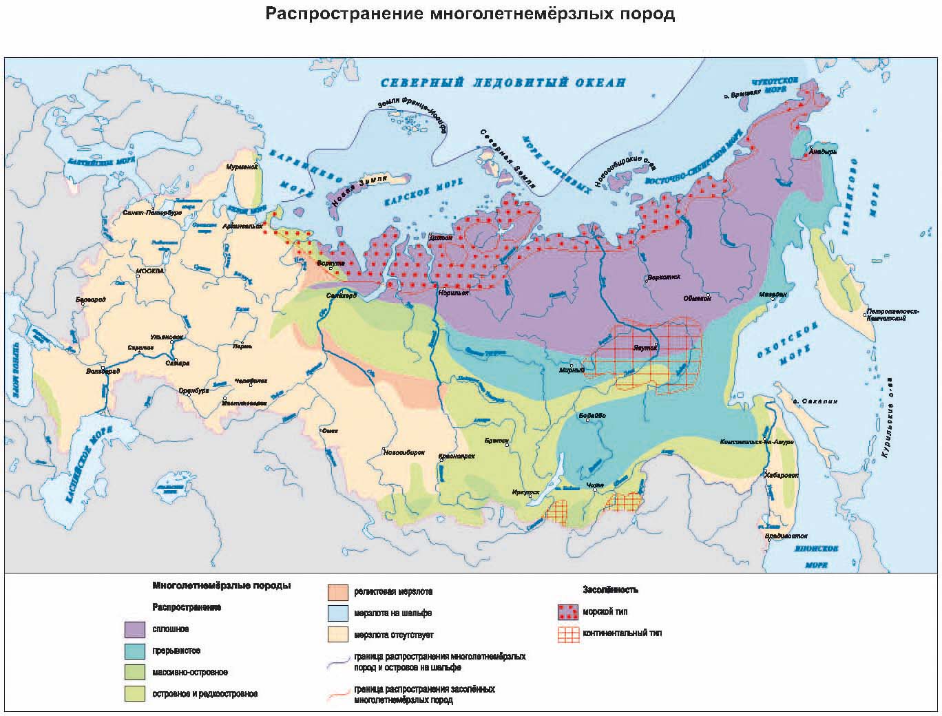
Table 1
Distribution, temperature and thickness of permafrost in Russia
|
Zones (areas) |
Subzones |
Permafrost area,% |
Temperature, ° С |
Southern boundary of the subzones, ° N |
Maximum power, m |
||
|
European-West Siberian sector |
Asian sector |
European-West Siberian sector |
Asian sector |
||||
|
I North |
more than 95 |
-1 to -10 |
66,5–68 |
64–65 (50–60*) |
300–450 |
500 (200)– 1500*** |
|
|
II South |
IIa |
75–95 |
from -0.5 to -3 |
65–67,5 (53–58*) |
60–64 |
100–450 |
100–700 |
|
IIb |
25–75 |
from 1 to - |
63,5–66 |
58–62 (50**) |
50–300 |
(1000***) 0–100 |
|
|
IIc |
less than 25 |
1 from 2 to -0.5 |
61 |
52–60 |
0–200 |
0–50 |
|
* Primorye and Khabarovsk Territory; ** Transbaikalia; *** Left bank of Vilyui, river basin. Markha
On the shelf of the Arctic seas of Russia, there are islands of frozen rocks up to 50–100 m thick. The largest of them is relict permafrost, which has not yet thawed after the last (Sartan) freezing.
The northern coastal lowlands are characterized by saline frozen rocks containing more than 0.05% soluble salts in their composition. This is prey predominantly clayey marine sediments that did not thaw in the epoch of climatic optimum and retained the primary salinity. They are most typical for the Bolshezemelskaya tundra. and the Yamal and Gydan peninsulas in Western Siberia. In Central and Eastern Siberia, the area of saline frozen rocks is there is only a narrow strip along the Arctic th coast, penetrating inland along the valleys of the Lena and Kolyma rivers. Into the pool the Lena River has the world's largest area of continental salinization of permafrost, associated with a sharp predominance of evaporation over the atmosphere spheral sediments. Locally continent Salinization is also found in intermontane depressions of the Baikal region.
The structure of permafrost rocks depends mainly on the distribution of ice inclusions in them. In crystalline and metamorphic rocks, ice occurs in the form of veins filling cracks, in sands - in the form of lenses or small crystals, in clays, loams, sandy loams and peat - in the form of interlayers (schlieren) or mesh. There are also large deposits of underground ice, genetically subdivided into vein (wedges), stratal, buried and cave.
A special place is occupied by giant ice veins, the formation of which began in the Sartan Ice Age and continued for hundreds and thousands of years. As a result, the ice wedges grew to 20-50 m high and 3-5 m wide and merged into an almost solid mass of ice. Such ice strata are widespread within the North Siberian, Yano-Indigirskaya and Central Yakut plains and on the coasts of the northern seas. Their total volume on the territory of Russia is about 1 thousand km 3.
In the north of Western Siberia and the East European Plain, a kind of natural phenomenon is the formation of underground ice deposits in Pleistocene marine sediments (thickness 30–50 m, dimensions in plan up to 1–2 km). In Eastern Siberia, they are much less common.
table 2
Permafrost evolution stages
|
Geological period |
Age, index |
Sectors |
Climatic era |
Sea level (relatively modern) |
Air temperature (rel. Modern) |
|
Middle Pleistocene |
150,000 (II2-4) |
Hebrew-West-Siberian |
Maximum glaciation (rice) |
100-150 m higher |
Lower by 5-6 ° С |
|
Asiatic |
Maximum glaciation |
Slightly higher |
Lower by 5-6 ° С |
||
|
Late Pleistocene |
125000-135000 (III1) |
Hebrew-West-Siberian |
Interglacial (Mikulinskoe, Kazantsevskoe) |
Slightly higher |
Higher by 2 ° C |
|
Asiatic |
Interglacial (Kazantsevskoe) |
Close to modern |
Higher by 3 ° C |
||
|
65,000 - 80,000 (III2) |
Hebrew-West-Siberian |
Glaciation (early Valdai, zyryanskoe) |
Below by 20-80 m |
Lower by 5-6 ° С |
|
|
Asiatic |
Glaciation (Zyryansk) |
Close to modern |
Lower by 7-8 ° С |
||
|
30,000 - 65,000 (III3) |
Evr.-Zap, -Siberian. and Asian |
Interglacial (Middle Valdai, Karginskoe) |
5-6 m higher |
Lower by 1 ° С |
|
|
18,000 - 20,000 (III4) |
Hebrew-West-Siberian |
Glaciation (late Valdai, sartan) |
Below by 100 m |
Lower by 10 ° С |
|
|
Asiatic |
Glaciation (Sartan) |
Lower by 7-8 ° С |
|||
|
Holocene |
5000 - 8000 (IV) |
Hebrew-West-Siberian |
Climatic optimum |
Slightly higher |
Higher by 2 ° C |
|
Asiatic |
|
Permafrost characteristics |
|||||
|
Temperature, ° С |
Thickness, m |
||||
|
On the land |
Under the glaciers |
Offshore |
On the land |
Under the glaciers |
Offshore |
|
-14 to -16 |
from -1 to 14 |
from -0.5 to -10 |
300–600 |
500–700 |
20–300 |
|
from –11 to –19 (from -14 to -22 in the mountains) |
300–700 (1000–2000 in the mountains | ||||
|
-2 to -4 (from –2 to –6 in the mountains) |
MMP * absent |
from -0.5 to -7 |
50-300 (50-400 in the mountains) |
MMPs are absent |
10–200 |
|
-2 to -8 (from –4 to –10 in the mountains) |
50-400 (300-700 in the mountains) | ||||
|
from –1 to –10 |
to 10 |
from 0 to -1.5 |
up to 300-500 |
up to 700 |
up to 500 |
|
from –3 to –13 |
up to 500 | ||||
|
Close to modern |
|||||
|
from –11 to –18 (from -13 to -21 in the mountains) |
-5 to -15 |
–3 to –5 |
400–700 (800–1500 in the mountains) |
300–700 |
100–300 |
|
-9 to -20 (from -13 to -23 in the mountains) |
350–1000 (800–2000 in the mountains) | ||||
|
from –11 to –18 (from -13 to -21 in the mountains) |
MMP * absent |
0 to -7 |
200–400 |
MMPs are absent |
50–250 |
|
0 to -6 (-2 to -6 in the mountains) | |||||
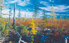 A raised bog in a perennial frozen rocks. Magadan Region
With the melting of ancient glaciers or icebergs, the processes of destruction (thermal denudation) of rocks were activated, and large blocks of ice could be buried under a thick cover of landslide or landslide deposits. They were “mothballed” by permafrost and remained for a long time in the thickness of frozen rocks. One of these glacial outliers was opened by the waters of the Yenisei in the Arctic Circle and was named Ice Mountain.
The permafrost distribution area is characterized by specific processes and phenomena called cryogenic. These are cryogenic weathering and frost cracking, frost heaving, ice formation, thermokarst, thermal abrasion, and various slope processes.
Distribution features, intensity of development and manifestation of exogenous processes are determined by landscape and geological factors. The formation of certain permafrost landforms is associated with these processes.
Frost cracking occurs as a result of sharp fluctuations in temperature on the earth's surface, leading to the rupture of frozen rocks and the formation of a polygonal system of cracks. Frost cracks in the warm season are filled with water, which subsequently freezes and turns into ice wedges. A polygonal grid of ice wedges appears. The sizes of the polygons depend on the temperature gradient and the physical and mechanical properties of the rocks and vary from 0.5 to 50 meters. Re-wedge ice occurs on accumulative plains in the bottoms of river valleys and in interfluves, forming mainly in sands or peat at rock temperatures below –3 ° C. The intensity of the process increases from south to north.
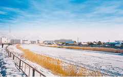 Winter channel. Yakutsk
Frost heaving of rocks is caused by an increase in the volume of freezing moisture and ice accumulation during freezing. This process is very widespread, mainly in loams, clays and peat. As a result of freezing of peat bogs in swampy lowlands, hilly areas with a relative height of several meters arise. Such formations are widely developed in the north of Western Siberia. When the average annual air temperatures fall below –6 ° C, freezing of the upper horizons of rocks often leads to the formation of perennial heaving mounds - hydrolaccoliths containing an ice core; they can reach heights of 30-60 meters with a diameter of 100-250 meters and are found most often in Transbaikalia, in Taimyr, in the north of Western Siberia and in Yakutia, where they are called Bulgunnyakhs. The development of heaving in the seasonally thawed layer leads to the sorting of soils with the formation of stone polygons, spots-medallions and stone placers of strips-curums (on the slopes).
Ice bodies formed as a result of layer-by-layer freezing of water on an open surface are called icing. They are formed during the cold season as a result of the outpouring of underground, river or lake waters, breaking through the ice or ground roof under significant pressure. According to the time of existence, one-year and perennial (not thawing completely in the summer season) ice are distinguished. The source of water is most often underground (ground and fissure) waters, so ice tends to be active tectonic structures and are most typical for mountain systems south and east of Siberia. The ice floes vary from very small (area up to one thousand m 2, volume up to one thousand m 3) to gigantic (area more than one million m 2, ice volume more than 22 million m 3). Large ice masses are found in the basins of the Yana, Indigirka, on the tributaries of the Lena. In Yakutia they are called Taryns. The largest tarn appears on the river. Moma, the right tributary of the Indigirka, this frost stretches along the valley in a huge tongue (3.5 km wide and 40 km long). Its thickness is 3–8 m, and its area is more than 100 square kilometers.
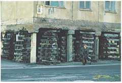 Residential building on permafrost. Norilsk
Thermokarst is the formation of subsidence and sinkhole landforms due to thawing of underground ice. The reason for its occurrence is such a change in heat transfer on the soil surface, in which the depth of seasonal thawing exceeds the depth of occurrence of underground ice and long-term thawing of the frozen frozen mass begins. The forms of thermokarst manifestation are diverse. The most common are swampy depressions and thermokarst lakes with a depth of 0.5 to 20 m. On the rises and slopes, large ice veins melt into a hummocky-depression relief.
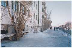 Frost under a residential building. Yakutsk
The question of the origin of numerous, sometimes very large lacustrine-thermokarst boggy basins, called alases in Yakutia, and Khasyrei in Western Siberia, raises many disputes. They are considered thermokarst formations associated with a decrease in the water area or drainage of thermokarst lakes as a result of their drainage by the river network. Thermokarst landforms are widespread in the northern coastal lowlands. With the distance to the south, the signs of the modern development of the process gradually fade away. Outside the permafrost zone, only relict thermokarst landforms are found, indicating a much more active development of the process in the past.
The process of destruction of banks, composed of frozen rocks, under the influence of mechanical energy of waves and heat of water is called thermal abrasion. Shores composed of icy frozen rocks or rocks containing large deposits of underground ice are destroyed much faster than thawed shores. The rate of their retreat often reaches several meters per year. The highest intensity of thermal abrasion is recorded on the shores of the seas and large lakes in the extreme North-East of Russia.
A peculiar group is formed by slope permafrost processes involved in the demolition, transit and accumulation of material, the so-called. solifluction is a viscous flow of silty loamy and sandy loamy rocks of the seasonally thawed layer on slopes with a steepness of up to 15 °. Solifluction is accompanied by the formation of characteristic forms of micro- and mesorelief: solifluction flows, stripes, terraces, etc. Along with solifluction, cryogenic landslides are widely developed, the gliding mirror of which is the roof of frozen rocks. Large blocks of seasonally thawed highly waterlogged rocks are quickly displaced by tens and hundreds of meters along slopes of different steepness us (from 3–7 ° to 10–25 °). Resistance process driven by ruptures of the sod cover. Cryogenic landslides and solifluction are common mainly in the Northern Subarctic.
Kurum formation is a complex process of cryogenic weathering of coarse material and its transportation down the slope. Daily and seasonal temperature fluctuations lead to cyclical expansion and contraction of rock debris and their pulsating downslope displacement. The transport speed of the material is usually a few centimeters per year. On wet slopes, material moves 3-4 times faster than on dry slopes. The sizes of the kurums are different, their area can be calculated in many square kilometers. They are most widespread near the southern boundary of the permafrost, in the mountainous regions of the Baikal region and the Far East, with a sufficient continental humid climate and changeable weather.
The study of permafrost is of great practical importance in various industries National economy country. Human engineering activity leads, first of all, to the destruction of the soil and vegetation cover, which in polar regions entails a sharp increase in the depth of seasonal thawing (sometimes 2–4 times), activation of thermokarst, thermal erosion and other cryogenic processes. When developing deposits, building, laying railways and highways, etc., it is necessary to take into account the possibility of heaving and subsidence of soils, sliding of thawed soils on slopes (solifluction, landslides), the formation of ice on roads, near bridges, and more. Saline frozen rocks significantly reduce the bearing capacity of soils. When large deposits of underground ice thaw, there is a catastrophic activation of slope processes, which also complicates construction. When developing the northern regions, it is necessary to take into account that their nature is very vulnerable, and the technogenic activation of cryogenic processes will make it difficult or impossible to restore natural geosystems for a long time.
Permafrost and its types. - section Astronomy, Earth, its composition and structure "Permafrost" (Permafrost Permafrost, Permafrost) - Part of the Cr ...
"Permafrost" (permafrost, permafrost) is a part of the permafrost characterized by the absence of periodic permafrost. Permafrost areas- the upper part of the earth's crust, the temperature of which does not rise above 0 ° C for a long time (from 2-3 years to millennia). In the permafrost zone, groundwater is in the form of ice, its depth sometimes exceeds 1,000 meters. The following structures:
· Permafrost soils that have existed for centuries and thousands of years.
· Permafrost (mm), existence for years, tens of years.
· Seasonal permafrost, existence of hours, days.
End of work -
This topic belongs to the section:
Land, its composition and structure
Engineering geology is understood as the science that studies the earth's crust as an environment for human life and activities. In the IG, the main ... The earth is its composition and ... Classification of minerals Sulfides sulphates halogens carbonates ...
If you need additional material on this topic, or you did not find what you were looking for, we recommend using the search in our base of works:
What will we do with the received material:
If this material turned out to be useful for you, you can save it to your page on social networks:
| Tweet |
All topics in this section:
Land, its composition and structure
The earth is part of the sun and we rot. From west to east around the sun. Has a companion moon. Consists of various shells and composition. Hydrosphere and atmosphere. The atmosphere borders on space.
Geosphere of the Earth
Inner geosphere of the Earth: Earth's crust(0-50), upper mantle (50-400), peridotite barrel (400-1200), lower mantle (1200-2900), liquid core Fe (2900-5000), solid core (5000-6370). Under the earth's crust is located
Basic geochronology. Eras and periods
Geochronology shows attribution. sequential geological events in the development of Z. At the heart of geological there are 2 prerequisites: - mutual change of sedimentary rocks in time. younger breeds always
Tectonic movements. Platforms and geosynclines. Dislocation types
Geological development of the land is under constant. the influence of endogenous processes (internal). lead to continuous deformation of the earth's crust, cat. yavl. thin shell. Deformation of the earth's crust appeared. in moved
Seismic phenomena. Earthquakes and Seaquakes - Seismographs
Manifested. in the form of elastic vibrations of the earth's crust and are observed in regions of geosynclines i.e. mountain builder. regions. annually on earth there is 1 catastrophic and up to 100 earthquakes. if the tecton. this
Rock-forming minerals, their structure and properties. Maos scale
Rock-forming minerals are minerals that are permanent essential components in the composition of rocks. The most important are silicates (75% of the mass of the earth's crust). For each
Minerals, oxide and silicate groups.
Oxides and hydroxides consumed about 200 minutes (more than 40 encounters on the ground of a trace of this type), they account for about 17% of the total mass of the earth's crust, while most of this amount is represented by compounds
Sedimentary rocks of mechanical and chemical origin.
The formation of sedimentary material occurs due to the action of various factors - the influence of temperature fluctuations, the effect of the atmosphere, water and organisms on rocks, etc. All these processes are pr
Organogenic sedimentary rocks and rocks of mixed origin.
Organogenic rocks are formed due to the accumulation of waste products of organisms: primarily marine and, to a lesser extent, freshwater invertebrates. Some organogenic rocks during
Basic properties of silty and clayey rocks
Clays are one of the most common types of rocks, making up up to 11% of the total volume of the earth's crust. Properties: Swelling Swelling is understood as the ability of clays
Geological activity of the wind. Aeolian deposits. Moving sands and control measures.
Wind is one of the most important exogenous factors that transform the topography of the Earth and form specific sediments. This activity is most clearly manifested in deserts, which occupy about 20% of the surface.
Weathering of rocks and its types. Weathering crust. Eluvium and its properties.
Weathering is physical, chemical and organic (biological). Physical weathering - mechanical crushing of rocks with almost no change in their mineralogical composition. This is happening
Anti-weathering measures
Weathering control measures can be constructive and conservation. Constructive measures are to create rational structures (no protrusions, cornice
Geological activity of flowing waters. Types of erosion.
Blurring of rainfalls. trickles, developed. in the form of streams and rivers, called. water erosion. There are 2 types of water erosion on the surface of the earth: flat (flat washout), jet. Flat leads to alignment
Deluvial and proluvial deposits
Deluvium, deluvial deposits, deluvial trail - an accumulation of loose products of weathering of rocks at the foot and at the lower parts of the hills. Deluvium is very widespread and about
Ravines. Era of prevention and development.
A ravine is a form of relief in the form of relatively deep and steep-sloping un-turfed troughs formed by temporary streams. Ravines arise on elevated plains or hills folded by p
The structure of erosion of river valleys. Alluvium and its properties. River erosion control measures.
The structure of the river valley in cross section. The main elements of the river valley are the river bed, floodplain and above floodplain terraces and their slopes. The channel is the lowest part of the river d
Geothermal zones of the earth's crust. Geothermal step in the depths of Belarus.
GEOTHERMIA (GEOTHERMIKA) is a science that studies the thermal field of the Earth. Determination of temperature in the Earth's shells is based on various, often indirect, data. Most Reliable Temperature Data
Glaciers and glacial deposits. Properties of Moraine and Fluvioglaceal Sediments.
Glacier - a mass of ice of predominantly atmospheric origin, experiencing a viscoplastic flow under the influence of gravity and taking the form of a stream, a system of flows, a dome (shield) or
Tape clays and their properties.
On the way, adjacent to the melting glacier, fine-grained sediments are deposited. At the same time, in winter, when the melting is minimal and the flows are weak, in these lakes, finely dispersed fractions (clay
Seasonal freezing of soils.
In winter, the soil freezes to a certain depth, and in the warm season it thaws. This is the seasonal freezing of the soil. The depth of the sounding is different from fractions of a meter in the south and up to 3-4m for sowing and hovering
Standard depth of seasonal freezing of soils in Belarus
Seasonal freezing of soils on Bel from 102 to 150 cm. Under the conditions of Bel. Freezing of soils depends on many factors and fluctuates within wide limits. Thanks to many years of measurements in various
Frosty heaving of soils
During freezing, soils (silty loam and sandy loam) increase in volume, i.e. the progressive increase in progress refers to a large amount of ice in the near-surface part of the permafrost thickness.
Karst processes and karst rocks. Types of karst.
Karst - chemical dissolution of rocks, occurs as a result of the filtration of underground water, the end products are stalactites and stalagmites. When rocks dissolve in a rock massif
Zones of karst formation and cementation.
The raising or lowering of the karst massif, due to the movements of the earth's crust, causes a change in the position of the corrosion base. At the same time, the karst process either intensifies or weakens. Below level n
Measures to prevent karst formation and increase the strength of karst rocks.
Construction in karst areas is associated with significant difficulties, since karst rocks are an unreliable foundation. Hollowness reduces the strength and stability of rocks as foundations
Landslides and the causes leading to their occurrence. Landslide slope signs.
Landslides - sliding displacement of soils on the slopes of valleys, ravines, gullies, sea shores, excavations under the influence of gravity and the pressure of surface or ground waters. Landslides destroy the
The degree of slope stability.
Determine the ratio of forces seeking to push the mass of rocks down the slope to the forces that resist this shear force. The degree of stability of the slope is determined by the ratio
Anti-landslide measures are passive and active.
Landslide control is a very difficult task. Landslide antislides are prescribed taking into account the activity of the landslide and subdivided into passive and active (engineering). Passivevlprophylactic
Theories of the origin of groundwater.
The waters of the upper part of the earth's crust are called underground. 1) infiltration (groundwater comes from atmospheric precipitation, which penetrate the ground through the smallest channels of rocks, where
Groundwater. Aeration zone and capillary border.
Groundwater - constant in time and significant in the area of distribution of the horizons of groundwater on the first aquiclude from the surface. They are characterized by a number of features: 1.
Maps of hydroisogypsum and determination of the direction of movement of groundwater.
Hydroisohypsum maps reflect the nature of the surface (mirror) of groundwater (Fig. 56).
Artesian waters. Overhead and piezometric level. Top and bottom of the confined bed.
Artesian water - groundwater trapped between water-resistant layers and under hydraulic pressure. They occur mainly in pre-Anthropogenic deposits, within large geological
Artesian basin, its main properties.
An artesian basin is an underground reservoir of fresh water. Within the artesian basin, three areas are distinguished: nutrition, pressure and discharge. In the recharge area, the aquifer is usually uplifted
Aggressiveness of groundwater and its types.
Aggressive pv-pvolzhimich-th composition, the cat has a destructive effect on concrete and metal structures, well filters, casing pipes, pumps, etc. Aggress effect on concrete caused it to swell and crumbling.
Industrial and thermal waters.
Industrial water is a natural highly concentrated aqueous solution of various elements, for example: solutions of nitrates, sulfates, carbonates, brines of alkaline halloids. Industrial water contains co
Mineral medicinal waters.
Mineral waters are natural waters that are the product of complex geochemical processes. They have a therapeutic effect on the human body, due to either an increased content of useful
The actual speed of movement and the speed of filtration of groundwater.
THE VELOCITY OF GROUNDWATER MOVEMENT VALID (TRUE) - the speed of movement of groundwater in the pores or cracks of the city. It is determined using indicators introduced into the aquifer, or by dividing
Power, pressure gradient, flow rate and direction of movement of the underground flow.
Head gradient is the change in head per unit of path length. The flow rate is a quantity proportional to the cross-sectional area of the flow and the head gradient in the direction of travel. Distance of the tap
Depression funnel during well and channel operation in pressure and non-pressure reservoirs.
During the operation of a water well, a depression funnel of the surface of the groundwater level is formed around it, within which water moves to the well. With limited natural resources ar
Determination of the direction of groundwater.
In the absence of maps reflecting the position of the free or piezometric surface of groundwater, in order to determine the direction of their movement, it is necessary to have at least three workings in order to establish
Methods for determining the filtration coefficient of soils.
Methods for determining the filtration coefficient according to GOST 25584 are used for sandy, silty and clayey soils and do not apply to soils in a frozen state, and also do not establish coefficients
Determination of the speed of movement of groundwater
We only note that the most important means for experiments to determine the actual speed of groundwater movement are the so-called indicators (coloring matter
Purpose, tasks and composition of engineering and geological surveys.
ENGINEERING AND GEOLOGICAL RESEARCH- a set of works aimed at studying the interaction different types engineering activities (construction, mining) with the geological environment. In tasks
Exploration work. Drilling, electrical exploration.
In areas where prospecting geologists have found significant signs of minerals, prospecting and exploration work is being carried out. The network of routes thickens, ditches are dug, pits are laid, and other times
Reservoir drainage - The reservoir drainage system is laid at the base of the structure to be protected directly on the aquifer.
The wall drainage system consists of drainage pipes (with filtering sprinkles) laid on waterproof soil from the outside of the structure. The ring drainage system is located along
Suffusion phenomena and their difference from karst ones.
Suffusion is the removal of small particles from a rock under the influence of a filtration flow (underground water). Small particles are detached from the rock and carried out of it. There are two types of suffoses
Compression and stamp studies of soils.
Compression refers to soil compaction with the displacement of air from the pore space. Dynamic influences from traffic, pile sinking and earthquakes can cause a similar compaction effect.
SPECIAL CASES OF BODYWATER
§ 8. Permafrost (perennial)
Perennial, or permafrost, is a stratum of rocks in the earth's crust with a negative temperature, stable for a long time, regardless of the physical state of the water contained in the rocks. The area of permafrost distribution in the USSR is 49.7% of the entire territory of the country, and on the globe - up to 24% of the entire land area.
The study of permafrost and construction conditions in the regions of its distribution is of great national economic importance. Numerous deposits of a wide variety of minerals have been identified here: coal, iron ores, diamonds, tin, tungsten, nickel, gold, oil, gas and many others, which caused the growth in these areas of the mining industry and the development of other sectors of the national economy and related housing. and road construction.
The natural conditions of the regions where permafrost is spread determine special requirements for the design, construction and operation of structures, non-observance of which leads to deformation of structures or their destruction.
The origin of permafrost is due, in the opinion of most researchers, to the fact that during the year the earth's crust loses more heat than it enters, and winter freezing exceeds summer thawing. In general, the details of these processes have not yet been sufficiently studied, and the exact reasons for the origin of permafrost have not been clarified.
The thickness of the permafrost strata depends on many factors: on the temperature regime of the atmosphere, soil and lithosphere; from the nature of the relief, vegetation; from the thickness of the snow cover; from the presence of surface water bodies and drains; from the circulation of groundwater; from geochemical processes occurring in the lithosphere; from human production activities. The thickness of permafrost varies from several meters to 600-800 m, and in the basin of the river. Vilyuya exceeds 1000 m.
Permafrost cannot be regarded as a continuous screen separating surface water from groundwater; their distribution is intermittent. The degree of discontinuity depends on many natural factors: climatic, geological, hydrogeological, orographic, tectonic, etc. Even in the Far North of our country, under lakes, along river valleys, in areas of young tectonics and in other places, rocks with a positive temperature are widespread. The degree of discontinuity of permafrost increases in the direction from north to south, and gradually permafrost transforms into thawed.
The upper layer of the earth's crust in areas of permafrost distribution thaws in the spring and summer, and freezes in autumn and winter. If this layer, during freezing in winter, does not merge with the permafrost layer, then it is called the seasonally freezing layer, and if it does merge, it is called the seasonally thawing, or active, layer. Active layer thickness in different places ranges from fractions of a meter to 6-8 m. In finely dispersed soils - loams and clays - the depth of seasonal freezing and thawing rarely exceeds 2-3 m.
The experience of construction in areas where permafrost soils are spread shows that underestimation of the regime of the active layer leads to the most sad consequences: roads, airfields, buildings and other structures are deformed and even destroyed. Therefore, the establishment of the thickness of the active layer and its temperature regime is essential and is one of the main tasks in engineering surveys.
Often, the depth of winter freezing does not reach the permafrost strata of rocks. The active layer formed during the summer period does not merge with the permafrost. This is spilling permafrost. Sometimes there is an alternation of thawed and permafrost layers of soil to a considerable depth. Such a bedding is called layered, or discontinuous, permafrost. This is due to the presence of coarse-grained and fractured rocks, but with which groundwater circulates at a high speed, which protects them from freezing.
Underground, permafrost waters, according to N.I. Tolstikhin, are divided into three categories: suprapermafrost, interpermafrost and subpermafrost.
The suprapermafrost waters overlying the permafrost zone are, in turn, subdivided into waters of the active layer and waters of perennial suprapermafrost taliks.
The suprapermafrost waters of the active layer lie on the layer of permafrost, which is a waterproof bed for them. A characteristic feature of these waters is the seasonal change of liquid and solid phases. In the north, the duration of the existence of the liquid phase is determined by two to three months of the summer-autumn period; towards the south, the existence of the liquid phase increases to six months or more. The waters of the active layer are nourished by atmospheric precipitation and partly by surface watercourses.
Chemically, the suprapermafrost waters of the seasonal layer are characterized by low mineralization, a significant content of organic matter, and the presence of humic acids. Their temperature is low and rarely exceeds 5 ° C.
The suprapermafrost waters of perennial taliks exist due to the thermal effect of surface waters. Similar taliks occur under lakes and river beds. Along the heat-bearing river valleys of Siberia, there are through taliks, through which the connection of suprapermafrost, interpermafrost and subpermafrost waters is carried out. These waters are distinguished by the constancy of quality and quantity. Their mineralization is low, hardness 0.8-1.2 mg eq; they are widespread in the basins of the Lena and Kolyma rivers. The flow rate of capturing structures (wells, galleries) often reaches 47 l / sec. Water data is used for drinking and utility water supply.
Interpermafrost waters. To interpermafrost waters, along II. II. Tolstikhin, referred to as liquid water circulating in the massif; permafrost, and the solid phase - fossil ice and frozen aquifers temporarily preserved by permafrost, which once functioned. The main factor that protects liquid permafrost waters from freezing is their dynamism, and sometimes also high salinity. By the nature of the host rocks, there are stratal, karst and fissure-vein rocks. interpermafrost waters.
When driving mine workings in the case of intersection of interpermafrost waters, the tributaries may increase over time, which is due to an increase in aquifers due to thawing of ice in cracks, frozen aquifers, etc.
Permafrost waters. All underground waters below the permafrost layer are called subpermafrost waters. These Vedas have a pressure, often several hundred meters. By the nature of occurrence and circulation conditions, subpermafrost waters are similar to groundwaters in non-permafrost regions. The conditions of feeding and runoff of subpermafrost waters are different.
According to the hydrogeological conditions among the subpermafrost waters, PI Tolstikhin distinguishes the following types: alluvial, porous-stratal, fissure-stratal, fissure or vein, and fissure-karst.
Alluvial under permafrost, the waters are fed due to the seepage of atmospheric waters along taliks in the alluvium, the inflow of groundwater from the bedrock and due to condensation. The permafrost waters of alluvial deposits have a temperature close to zero. Only in those cases when the waters of bedrock with a higher temperature take part in the feeding of alluvial waters, the subpermafrost waters of alluvium have an abnormally high temperature.
The chemical composition of alluvium subpermafrost waters is characterized by a lower content of organic matter.
Subpermafrost waters of alluvial deposits play a negative role in the development of many placer mineral deposits; a lot of material resources have to be allocated to combat them.
Pore-stratal subpermafrost waters occur in sedimentary rocks and have a hood. In many places, artesian basins of subpermafrost waters have been identified.
Fissured-stratal subpermafrost waters are characteristic of rocks of ancient age (Paleozoic - Jurassic). They circulate along cracks in layers of sandstones, limestones, conglomerates and other rocks overlain by impermeable seals. In particular, in many deposits of coal, widespread in the permafrost zone (Bukachachinsky, Bureinsky basins, etc.), subpermafrost waters of this type are confined to fractured sandstones, conglomerates, and occasionally to siltstones and coal seams. Clay rocks are water-resistant and divide groundwater into a number of aquifers. Waters have a pressure of tens to hundreds of meters.
Fissured and fissured-karst subpermafrost waters are associated with tectonic faults. These waters are noted in many places in Transbaikalia, in the Aldan basins, on the Lena and in other places. The regime of these waters is even more unstable. Limestones in the area of permafrost are the most water-abundant rocks; they are associated with outcrops of large springs, where thick ice is formed.
Sources in the permafrost zone. Permafrost regions are characterized by specific conditions for groundwater discharge to the surface. Sources are divided into descending and ascending. Descending springs are formed due to suprapermafrost waters located above the local erosional basis. According to the regime, the sources of suprapermafrost waters are divided into seasonal and functioning throughout the year. The debit of those and other sources is unstable.
Ascending springs are formed due to the outflows of subpermafrost waters. The geological conditions of the outcrops of subpermafrost waters are very diverse. The source regime is complicated by permafrost factors - thawing and freezing of water flow paths, which determines the division of the rising sources into the following types: periodically disappearing, migrating, seasonal changeable, variable in flow rate and constant. The rising springs regime, which is dependent on freezing and thawing of water paths, does not reflect the true state of the aquifer feeding these springs. High-rate ascending springs are formed in the places where fissure-karst subpermafrost waters come out to the surface.
Permafrost related phenomena. In the area of permafrost distribution, ice, hydrolaccoliths, thermokarst, solifluction and heaving are observed.
Frost - an ice body formed on the surface of the earth or on the ice of a river as a result of freezing of underground or river water that poured out onto the surface of the earth or the ice cover of the river. Distinguish between ground, or ground, ice, river and mixed.
Ground ice is formed when groundwater emerging to the surface freezes.
River ice develops as a result of an increase in the head of the bottom in a freezing river in places of a sharp narrowing of the flow area or filling the channel with ice. River ice deforms bridges, pipes, water intake structures, and also significantly complicates the movement of transport on winter roads on the ice of rivers
Rice. 8. Hydrolaccolith (according to M. Ya-Chernyshev)
1 - rocks of the active layer; 2- -ice;
3 - aquifer cracks
Hydrolaccoliths - swelling mounds arise due to the formation of ice in the thickness of the frozen rocks (Fig. 8), ie, during the formation of underground ice. There are annual (seasonal) and perennial hydrolaccoliths. Hydrolaccoliths are rounded and dome-shaped with varying heights. There are also gentle swellings and roll-shaped uplifts. The most important in the formation of hydrolaccoliths are submerged taliks, when freezing, hydrolaccoliths are formed with heights from several meters to 70-80 m.In diameter, large hydrolaccoliths sometimes reach 200-250 m.
Ground ice and heaving mounds are a reliable search indicator for groundwater in areas of permafrost distribution.
Thermokarst - closed funnel, hollow or saucer-shaped depressions formed as a result of thawing of buried ice or thawing (degradation) of permafrost soil with its subsequent compaction. Thermokarst in many areas of permafrost occupies up to 30% of the area and more. Thermokarst depressions are usually filled with water, forming lakes, swamps with an area of hundreds of square meters, and sometimes even kilometers. With the formation of new thermokarst depressions under the influence of local changes in the thermal regime of permafrost rocks, which occurs during the development and development of new territories, a serious threat to various engineering structures arises. Therefore, during the economic development of new territories, it is necessary to conduct special studies in order to identify the potential for the development of thermokarst processes.
Solifluction is the flow of waterlogged thawed soil of the active layer under the influence of gravity. Solifluction is widespread in the Far North. It appears on slopes at small angles (several degrees). There are known cases of the transition of solifluction melting into landslides of a catastrophic nature. Solifluction phenomena cause significant damage to various structures, mainly roads traced along slopes or on slopes.
Swelling is the process of increasing the volume of freezing soil, which occurs both as a result of an increase in the volume of freezing moisture, and as a result of the formation of layers and ice lenses in the freezing soils, which is especially intensive in conditions of a migratory flow of water from the outside to the freezing front. Particularly thick layers and lenses of ice are formed with a long delay of the freezing boundary at a certain depth and the close position of the groundwater table to it. If freezing is intense (during severe frosts), then the water in dispersed soils does not have time to catch up to the freezing front and lenses and ice layers are not formed, but only individual ice crystals appear, scattered throughout the mass of the soil and firmly cementing it particles.
The frost heap has a negative impact on various structures, but the greatest complications are caused by the roadbed and railways, including those on the entrance and exit roads in quarries, as well as airfield pavements. Usually, the uplift of the ground is uneven, which changes the profile of the roadway or surface and introduces significant complications in the operation of transport. In spring, during thawing, the soil of heaving places liquefies and loses its ability to maintain the road surface.
Heaving on roads and airfields is noted not only in the area of permafrost distribution, but also in the regions of seasonal permafrost, although it is manifested here less intensely.
Construction conditions in permafrost regions. In connection with the implementation of a broad program for the construction of various structures in the areas of permafrost distribution, the issues of taking into account the peculiar climatic, hydrogeological and soil conditions of specific construction sites where the construction of facilities is planned are acquiring great importance.
The practice of construction in these areas shows that as a result of construction, the temperature regime at construction sites is violated and, as a result, the hydrogeological conditions and physical and mechanical properties of the base soils change significantly. Usually, the frozen soils of the foundations thaw out under the influence of heat transfer from structures, often to a considerable depth, and the thawed soils become more or less subsiding. Depending on the speed of the thawing process, structures undergo deformations, often significant. Consequently, structural solutions in the design and construction of structures, made without taking into account their deformation-stress state and the conditions of joint work with thawing subsidence soils, lead to the premature destruction of capital buildings built on such soils. This is evidenced by the long-term practice of construction in the regions of Vorkuta, Norilsk, Transbaikalia, Yakutsk, Magadan, etc.
As indicated, in the areas of permafrost distribution, deposits of many minerals are concentrated: coal, iron ore, non-ferrous metals, as well as diamonds, gold, etc. When developing deposits in these regions, one has to reckon with the following features: labor intensity of the development of loose frozen rocks increases in comparison with thawed ones by about 10-15 times; with natural ventilation in winter, rock cooling and ice formation are observed in the workings; when ventilating the workings with heated air, the temperature of the frozen rocks increases, their ice content decreases, which introduces significant complications in the course of work; the hydrogeological conditions are specific here, often complicating the conduct of mining operations; the thickness of frozen rocks only temporarily and even then does not always protect the workings from surface and ground waters.
To combat the negative phenomena of groundwater for underground work, it is necessary, according to V.P. Bakakin, to preserve the natural state of frozen rocks by any means.
When conducting open pit mining, the main complicating factor is the significant strength of the permafrost. According to A. N. Zelenin, loam with a moisture content of 20% in the thawed state has a cutting resistance of 5-7 kgf / cm  , and at -25 ° C up to 150 kgf / cm ... Therefore, the main measure that significantly improves the conduct of open pit mining is to reduce the energy intensity of the rocks being mined. To reduce the strength of the developed rocks, the most widespread methods are thermal and water-thermal reclamation, which, in comparison with the explosive method of loosening, are about 10 times cheaper. Under certain conditions, it is possible to achieve the depth of thawing of loose rocks from the surface up to 6-9 m or more without the use of labor-intensive expensive engineering work. This makes it possible to use high-performance mining machines, dredges, excavators, spoilers, etc. at the mines, which sharply increases the intensity of development, labor productivity and reduces the cost of production.
Currently, various options for thermal and water-thermal reclamation are used: by using natural thermal processes (snow retention in winter and snow removal in early spring, burning of vegetation and moss cover, blackening of snow, etc.); thawing frozen soils by injecting water into them; filtration and drainage method. The disadvantage of these methods is the length of the preparation period, but with appropriate planning of preparatory and cleaning works, they give a significant effect.