1/3 of the territory is located within the temperate zone North America... Thermal conditions and humidification are not uniform. Due to the increase in the annual value of the radiation balance by an average of 6 KJ / cm 2 for each degree of latitude, latitudinal zoning is clearly traced.
The largest territory within the temperate zone is occupied by natural complexes of the forest zone, including subzones of taiga, mixed, broad-leaved and western oceanic coniferous forests.
Taiga subzone stretches from the Atlantic coast in the east and the Pacific coast in the west. It is characterized by moderately humid, sometimes severe snowy winters and warm, short summers. The average minimum temperature is 25 ° C, the amount of precipitation is 400-700 mm per year. Permafrost is not ubiquitous. The vegetation cover of the taiga is characterized by dark coniferous forests. Tree stand central regions Taiga is mainly formed by three types of trees: black spruce, white spruce, balsam fir. American larch and paper birch, prevailing in clearings or burnt-out areas, as well as several types of poplar are widespread. Along with spruce and spruce-fir forests, forests of white pine, or Weymouth pine, red pine and Banks pine are widespread. The taiga of North America is in many ways similar to the taiga of Europe.
Under the canopy of coniferous trees, as in the Eurasian taiga, podzolic soils are formed.
The taiga is not uniform throughout. The western part of the subzone, located in the Mackenzie River basin, is distinguished by a sharply continental and dry climate; it is dominated by dry sparse forests with light needles (pine, white spruce, larch), and in the southern part there are small-leaved species, in particular aspen. The prevailing soils are gray forest soils.
The southern part of the eastern sector of the temperate zone is the territory adjacent to the Great Lakes, and most of the Appalachian Mountains are landscapes subzones of mixed and deciduous forests. The climate is moderately warm and rather humid. The winter period is characterized by intense cyclonic activity, causing frequent precipitation, mainly in the form of snow. There is also a lot of precipitation in summer, as moisture comes here from the Gulf of Mexico. Thermal winter conditions are an important landscape-forming factor.
The northern half of this area is occupied by subzone of mixed forests. In mixed forests, among broadleaf forests, the dominant position is occupied by various types of maple: sugar, red, silver. There are also large-leaved beech, American linden, American elm, ash, yellow birch; rock oak is widespread. Conifers grow along with deciduous trees: Canadian hemlock, thuja, pine, spruce, fir, larch - typical representatives of taiga vegetation.
In the most humid eastern part of the Central Plains and in the foothills of the Appalachians, subzone of deciduous forests, which comes to subtropical belt, deciduous trees are beginning to be replaced by evergreens. Pine predominates among conifers on outwash terraces or steep rocky slopes of the primary banks of river valleys. On the Appalachian plateau, oak and beech are found, in the east of the Central Plains - oak and some relict plants, in particular tulip tree, hickory, liquandamber, etc. The main forest-forming species include oak - white, red and large-fruited, hickory, linden, beech, chestnut , deciduous magnolia, black walnut, western sycamore. Dense undergrowth, lianas, various grasses complement the richness of deciduous forest vegetation. It is associated with the fertility of the accompanying brown forest soils.
Landscapes subzones of western oceanic coniferous forests are formed on the territory of the Cordillera mountain belt under the strong influence of the Pacific air masses. This subzone includes only mountainous landscapes, which differ significantly from the plain ones even in the lowest belt of mountains. In different parts of this region, four types of mountain landscapes are distinguished: meadow-tundra; meadow-tundra oceanic; forest-tundra continental; forest meadow.
The Cascade Mountains, the Canada Coast Ridge, the northern United States Coast Ranges, the Rocky Mountains, the most humid but unshaded lower western slopes are home to extremely productive Douglas pine forests (Weymouth pine). Douglasia (Douglas fir, or pseudo-tree) is one of the largest trees in the world, their height sometimes exceeds 100 m, their diameter reaches 1.5-2 m. The densest forests are characteristic of the coast. It is dominated by thuja and western hemlock. Closer to the peaks and on the eastern slopes prevail different types pines (yellow and sugar), forming light, grassy pine forests.
At the upper border of the forest, at an altitude of 1500-2000 m, there are rare forests of spruce, fir and larch, and higher - tall-grass grasses and sedge subalpine meadows, turning into alpine low-grasses.
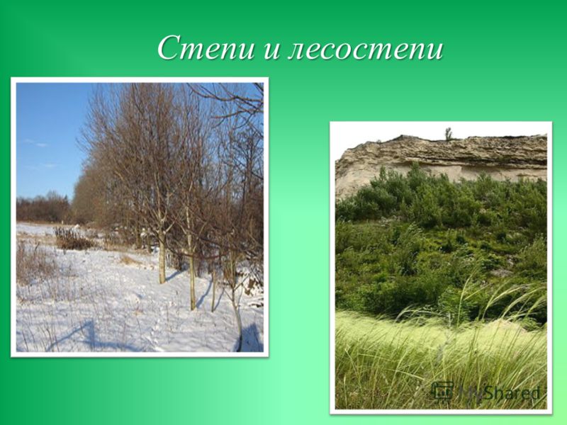
Prairie subzone takes western part Central plains and is a transitional subzone between deciduous forests and steppes. Compared to the forest-steppe, the prairie receives much more solar heat, the amount of precipitation reaches 800 mm.
Among the many dozen species of grasses, blue and small bearded vultures prevail. Among other cereals, there are less tall ones - Indian grass, meadow bluegrass. Of the flowering plants, white and pink immortelles, blue astragalus, light yellow rosewort, and yellow goldenrod are widely represented.
The peculiarities of the climate and vegetation cover have left their mark on soil-forming processes. As a result of the withering away of plant organisms, a large amount of organic matter remains in the soil every year, replenishing the reserves of humus. However, the thickness of the humus layer and the humus content are less here than in chernozems. This is due to the fact that in prairie soils, as in brown forest soils, the abundance of heat and moisture generates rapid humus mineralization. All these signs make it possible to distinguish the soils of this subzone into a special type - prairie chernozem soils. The area of distribution of these soils corresponds to the center of the US corn belt, one of the main agricultural areas of the country (Iowa). Prairie chernozem soils are formed on loesses. There are four types of prairie, which gradually replace each other from east to west as dryness increases. Meadow prairie located in the east of the zone and resembles a forest-steppe. The grass stand is high and closed (bearded grass, feather grass, wheatgrass, forbs). Shrubs and single trees, mainly oak, are found in the beams. Typical prairie forms a strip elongated from north to south, the axis of which almost coincides with the 100 ° W meridian. e. The dryness is higher than in the meadow prairie. Here, along with bearded grass and feather grass, Gramma grass, bison grass, asters, phloxes, "Indian summer", etc. are typical.
Mixed (dry) prairie differs in a smaller amount of forbs: gramma grass, bison grass, keleria prevail. The sod of the bearded man stands out.
Sod grass prairie is located to the west of the mixed and also occupies elevated sandy hillocks in the area of typical dry prairies. The grass sods are sparse. This type of prairie forms the transition from prairie to steppes.
The prairies are almost completely plowed up. The prairie area is now one of the most important agricultural areas in North America.
To the west of the Central Plains, annual precipitation drops to 600 mm per year and evaporation begins to exceed precipitation. Here is formed steppe zone, which occupies the territory of the Great Plains from the province of Alberta (Canada) in the north to the state of Texas (USA) in the south. Thus, the typical steppes stretch from north to south along the foothills of the Cordillera. They are also found in separate areas on the inner plateaus of the Cordilleras.
Most of the territory is occupied by dry steppes, located mainly within the Great Plains; they cover most of the Columbia Plateau and the south of the Fraser Plateau. Annual precipitation amounts to 400 mm. This does not provide sustainable crop yields, so a significant part of the land is not plowed up. From the herbaceous vegetation, there are local grasses - Gramma grass, bison grass, and fescue-like fescue. Wormwood grows on sandy soils. The soils of dry steppes - chestnut chernozems and chestnut soils of North America - differ from European ones in their low humus content.
Typical steppes occupy a narrow strip between forest-steppes and dry steppes; 550-600 mm of precipitation falls annually. Undulating black earth plains cut by ravines and gullies, once overgrown with local species of fescue and wheatgrass, bearded vulture, are plowed up almost everywhere.
The zone of deserts and semi-deserts occupies a smaller area compared to the vast areas that they cover in Eurasia. Deserts and semi-deserts in the temperate zone of North America occupy the driest part of the Columbia Plateau and the entire territory of the Great Basin. Annual precipitation in the continent's deserts barely reaches 250 mm. The scarcity of precipitation is due to the influence of the Cordilleras, which retain moisture on the western slopes of the ridges. The complex orography, the presence of numerous short ridges lead to the fact that the landscapes of deserts and semi-deserts do not form clearly separate territories, as on the plains of Central and Central Asia, but are distributed in separate areas. Most of the area has no drainage into the ocean, which leads to salinization. The main background of the vegetation cover is created by thickets of black wormwood bushes. This plant is more than 1 m high and has a powerful root system. Absorbing soil moisture, wormwood accumulates a lot of salts, which, after the dying off of plant organisms, remain in the upper layers of the gray-brown soils prevailing here. On solonetzic soils, thickets of quinoa are common. The largest plant in the deserts of the temperate zone is saxaul, a shrub up to 1.5 m high.
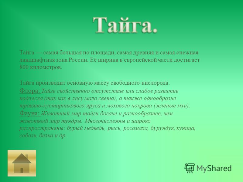
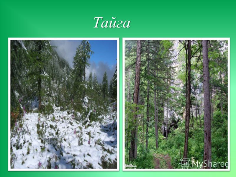
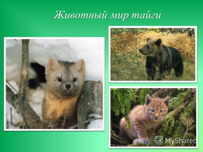
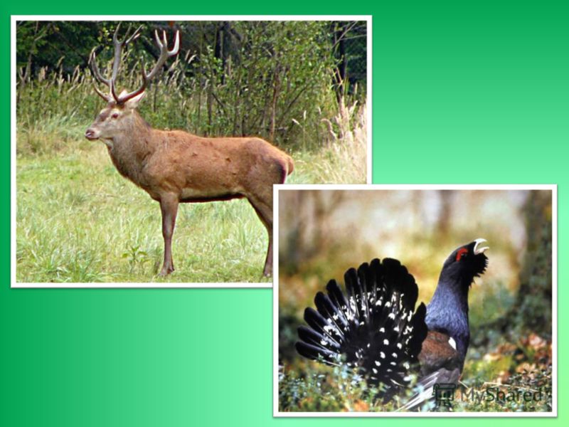
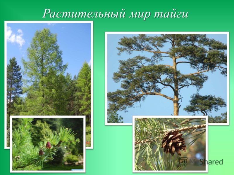
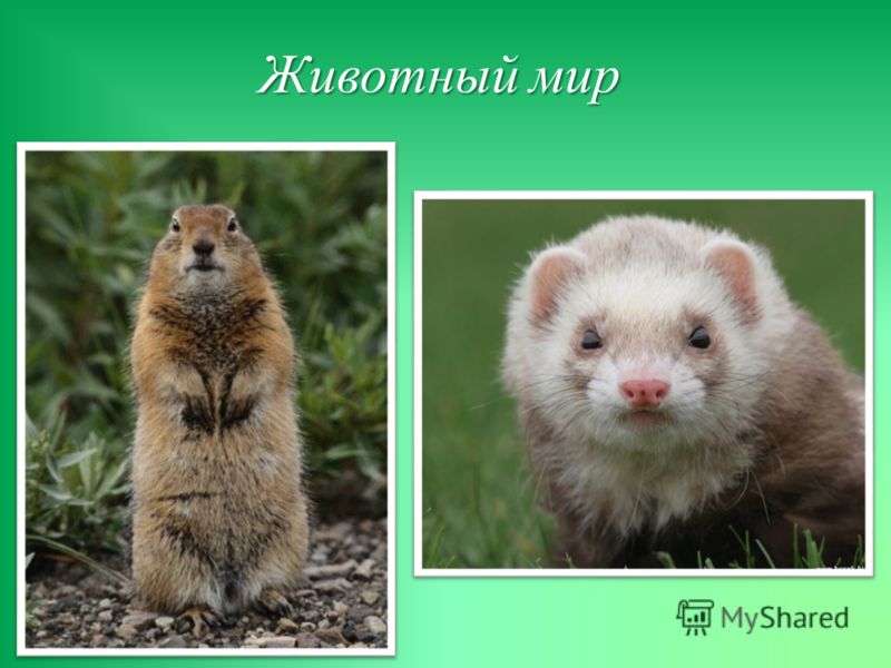
Taiga is the largest in area, the oldest and the snowiest landscape zone in Russia. Its width in the European part reaches 800 kilometers. Taiga produces the bulk of free oxygen. Flora: Taiga is characterized by the absence or weak development of undergrowth (since there is little light in the forest), as well as the monotony of the herb-shrub layer and moss cover (green mosses). Fauna: The fauna of the taiga is richer and more diverse than animal world tundra. Numerous and widespread: brown bear, lynx, wolverine, chipmunk, marten, sable, squirrel, etc.
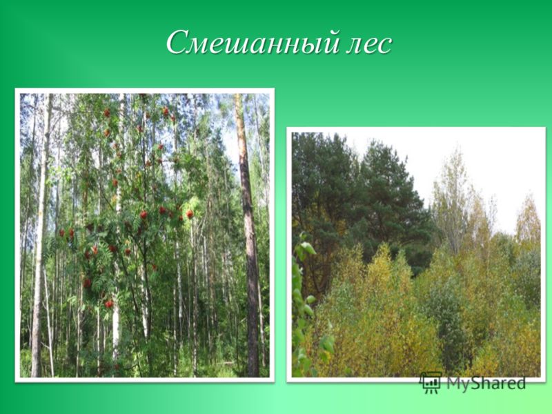
Southern taiga in the European part of Russia is being replaced mixed forests... The zone of mixed and deciduous forests has the form of a triangle, the base lying at western borders country, the top of the same abutting the Ural Mountains. The climate is moderately warm, rather humid; long, warm summer, mild winter (in the European part of the zone); Flora: oak, beech forests, birch, ash, berries and mushrooms are common. Fauna: very similar to the fauna of the taiga ...
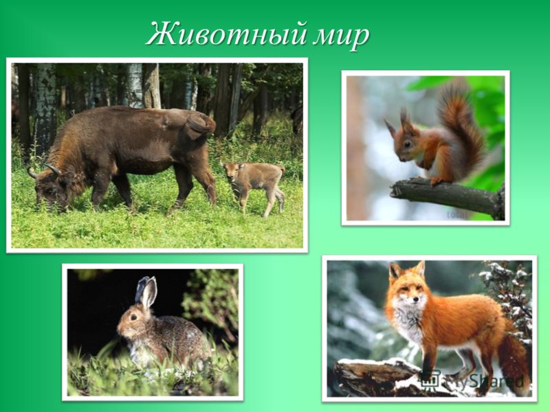
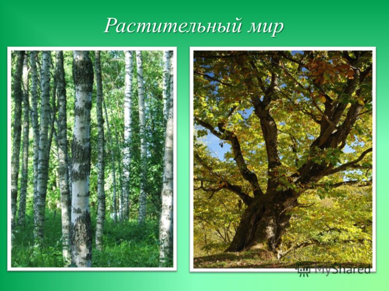
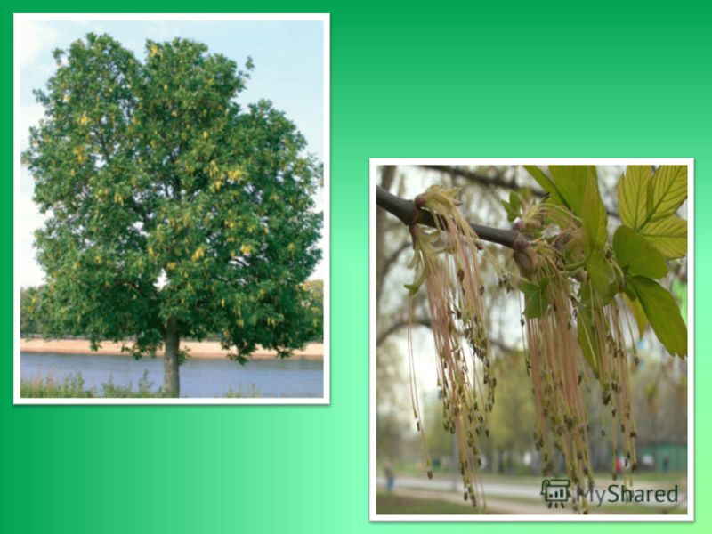
In Eurasia, the forest-steppe stretches in a continuous strip from west to east from the eastern foothills of the Carpathians to Altai. To the west and east of this strip, the continuous strike of the forest-steppe is disturbed by the influence of the mountains. Fauna: in the forest-steppe there are no special species of animals peculiar only to it. Steppe species (ground squirrel, marmot, bustard, etc.) combine and coexist here with typical forest representatives (squirrel, marten, elk). Flora: characterized by a complex alternation on the watersheds of picturesque massifs of deciduous forests (less often coniferous forests) with areas of forb steppes. In Europe and in the European part of Russia, light broad-leaved forests of oak (oak groves), beech, linden, chestnut, ash, etc. are typical.
Geographic belt- the largest regional division geographic envelope, encircling the globe in the latitudinal direction. Geographic zones correspond climatic zones... Each geographic zone is distinguished by the integrity of climatic conditions.
The globe is subdivided into the following geographic areas and belts:
- North Polar Zone - North of the Arctic Circle
- arctic belt
- North Temperate zone- between the Arctic Circle and the Tropic of Cancer
- southern temperate zone
- Hot Zone - Between the Tropics of Cancer and Capricorn
- southern tropical belt
- equatorial belt
- northern tropical belt
- South Temperate Zone - between the Tropic of Capricorn and the Antarctic Circle
- northern temperate zone
- South Polar Zone - south of the Antarctic Circle
- antarctic belt
The following belts are also distinguished on the borders:
- two subequatorial (north and south)
- two subtropical (northern and southern)
- subarctic
- subantarctic
In the Hot Zone, the sun is at its zenith at least once a year - at the edges of the tropics during the summer solstice, and at the equator during the equinoxes. It is the hottest (hottest) part of the earth and has two annual seasons: dry and wet. The hot zone includes most of Africa, South India, South Asia, Indonesia, New Guinea, northern Australia, Central America and northern South America. In the two Temperate zones, the sun is never directly at its zenith, the climate is temperate (mild), slowly changing from warm to cold. There are four seasons in these zones - spring, summer, autumn and winter. The Northern Temperate Zone includes the UK, Europe, northern Asia and North America. The South Temperate Zone includes southern Australia, New Zealand, southern South America and South Africa. In the two polar zones, there is a phenomenon such as a polar day and a polar night - at the borders of the zones during the solstice the sun does not rise for 24 hours, while at the poles, the day "lasts one year" - six months of sunshine and six months of night. The polar zones are the coldest parts of the earth, covered with ice and snow. North Polar Zone (Arctic) includes northern Canada and Alaska, Greenland, northern Scandinavia, northern Russia and arctic ice... The South Polar Zone (Antarctica) consists of the continent of Antarctica; other closest continents - south cape Chile and Argentina as well New Zealand.
10.The role of living matter in development crust, atmosphere, hydrosphere.
At the highest level of the hierarchy of biosystems is the global ecosystem - biosphere – the totality of all living organisms and their ecological environment within the planet. The "biosphere" was first applied by the Austrian geologist E. Suess (1873), defining the space of organic life on Earth. An outstanding role in the development of the theory of the biosphere belongs to the Russian scientist V.I. Vernadsky. In his classic work "Biosphere" (1926), he essentially rediscovered this concept, giving it the meaning and status of a global system in which all living organisms interact with each other and with environment, which have a decisive influence on planetary geochemical and energy transformations. The biosphere is a part of the globe within which life exists. It is a shell of the Earth, consisting of the atmosphere, hydrosphere and the upper part of the lithosphere, which are interconnected by complex biochemical cycles of migration of matter and energy. Vernadsky (1868-1945), one of the founders modern look on the biosphere, defined it as the outer shell of the Earth, the area of distribution of life, the basis of which is the interaction of living and inert matter.According to modern concepts, the biosphere is a kind of shell of the Earth containing the entire set of living organisms and that part of the planet's matter that is in continuous exchange with these organisms. In a biosphere that is very complex in composition, structure and organization, a relatively small number of main components can be distinguished:
- living matter Is a set of bodies of living organisms that inhabit the Earth, regardless of their systematic affiliation. The total weight of living matter is estimated at 2,400 billion tons (dry). According to V.I. Vernadsky's definition, living matter is one of the most powerful geochemical forces of our planet;
- nutrient - this is chemical compounds that have arisen as a result of the vital activity of organisms. In this case, the resulting chemical compounds may not be part of the bodies of organisms ( coal, peat, humus, chalk, limestone, oil, etc.);
- inert substance - This is a substance that is formed without the participation of living matter (rocks of the earth's crust of inorganic origin, water, air components);
- bioinert substance – these are products of the processing of rocks and sedimentary rocks by organisms;
- cosmic matter .
The biosphere in its main features can be characterized by the individual shells that it covers: the lower atmosphere, the hydrosphere, and the upper lithosphere. Atmosphere Is a gaseous envelope that surrounds the Earth. The atmosphere is considered to be the area around the Earth in which the gaseous medium rotates together with the Earth as a whole. The exchange of matter between the Earth and space takes place through the atmosphere. The Earth receives cosmic dust and meteorite material, loses the lightest gases: hydrogen and helium. The Earth's atmosphere is permeated through and through by the powerful radiation of the Sun, which determines the thermal regime of the planet's surface, causes the dissociation of atmospheric gas molecules and the ionization of atoms. The atmosphere has a layered structure, which is primarily determined by the features of the vertical temperature distribution: the troposphere (up to 10 km), the stratosphere (10- 47 km), mesosphere (47-80 km), thermosphere (80-1000 km). At altitudes over 1000 km, there is an exosphere, from where atmospheric gases are dispersed into world space. All structural parameters of the atmosphere (temperature, pressure and density) have significant spatio-temporal variability: latitudinal, annual, seasonal and diurnal. The composition of the atmosphere includes nitrogen (78 , 08% by volume), oxygen (20.95%), argon (0.93%), carbon dioxide (0.03%), neon, helium, methane, krypton, hydrogen, xenon, water vapor, ozone, etc. An important variable component of the atmosphere is water vapor. Spatio-temporal variability of its concentration ranges from 3% in the tropics to 2 · 10 -5% in Antarctica (y earth surface). The bulk of water vapor is concentrated in the troposphere, and its concentration rapidly decreases with height. The average content of water vapor in a vertical column of the atmosphere in temperate latitudes is about 15-17 mm of the "layer of precipitated water", that is, the layer of condensed water vapor will have such a thickness. One of the most important components of the atmosphere is ozone About 3... Ozone is mainly concentrated in the stratosphere, where its formation and decomposition is associated with the absorption of ultraviolet radiation from the Sun, which is destructive for living organisms: O + O 2 = O 3... The main amount of ozone is concentrated at altitudes of 20-25 km. The average monthly values of the total ozone content vary depending on the latitude and season and are the ozone layer thickness in the range of 2.3-5.2 mm at ground-based pressure and temperature values. The ozone layer - the "screen" is extremely important for the preservation of life on Earth. Hydrosphere - the water shell of the Earth. Due to its high mobility, waters penetrate everywhere into various natural formations. They are in the form of vapors and clouds in earthly atmosphere, form the oceans and seas, exist in a frozen state in the high-mountainous regions of the continents and in the form of powerful ice shells cover the polar land areas. Precipitation penetrate into sedimentary rocks, forming groundwater. Water is capable of dissolving many substances in itself, therefore any water in the hydrosphere can be considered as natural solutions of various degrees of concentration. The purest atmospheric waters contain 10-50 mg / L of dissolved substances, and seawater - up to 35 g / L. The hydrosphere is in close relationship with the lithosphere (groundwater), the atmosphere (vaporous moisture) and the living matter of the biosphere, into which it enters. as an obligatory component (a person is 70% water). According to V.I. Vernadsky, water stands out in the history of our planet, but it plays an important role in the geological history of the Earth. Water is one of the factors in the formation of physical and chemical environment, climate on our planet, the emergence of life on Earth. If the water of the hydrosphere is evenly distributed over the surface of the planet, it will cover it with a layer of 3000 m. But the average thickness of the earth's crust is ten times the average thickness of the hydrosphere, and the radius of our planet is 2100 times The overwhelming majority of natural waters make up the World Ocean (94%), which is a unique natural system of the biosphere. A grandiose process of exchange and transformation of the energy and matter of our planet takes place in it. At the same time, various physical, chemical and biological processes are combined, forming a single nature of the ocean. Since the formation of the ocean, its nature has changed under the influence of various natural processes: solar radiation, geological and geochemical factors and, most importantly, under the influence of biological processes. Biological processes have manifested themselves and are manifested in the development of living organisms, in biological productivity and sedimentation throughout the entire area of the ocean floor, in the formation of various kinds of organogenic silts. Sea (oceanic) water is a natural solution containing an average of 35 g of dissolved substances in 1 liter of water ... In general, we can assume that in sea water all chemical elements of D.I. Mendeleev. However, the predominant part of the dissolved substances is composed of a few chemical elements: O, H, Cl, Na, Mg, S, Ca, K, Br, C, Sr, B, F, Si, Rb, Li, N, P, J. Some of the elements, despite their low concentration, play an important role in ocean chemical processes and in marine organisms. In this regard, the leading role belongs to nitrogen, phosphorus and silicon, which are assimilated by living organisms, and their concentration in seawater is controlled by the growth and reproduction of marine animals and plants. One feature of ocean water should be noted - the main ions are characterized by a constant ratio throughout the entire volume of the World Ocean. This indicates the stability of the dynamic equilibrium between the amount of dissolved substances entering the ocean from the surface of the continents and their deposition. ocean water there are dissolved gases that are formed during the exchange of gases with the earth's atmosphere, with the participation of biochemical processes in the ocean and at its bottom, during degassing of the mantle in the regions of rift valleys and underwater volcanoes. So, if in the Earth's atmosphere there is the most nitrogen and oxygen in mass and a little carbon dioxide, then in the dissolved atmosphere of the ocean, the basis in mass is carbon dioxide, which is almost 100 times more than in the earth's atmosphere. Oxygen in the ocean is almost 100 times less and very little nitrogen. Other gases, such as hydrogen sulfide, argon, and methane, are also dissolved in noticeable quantities. In general, the mass of gases dissolved in the ocean is about 30 times less than the mass of the Earth's atmosphere. Water is the most powerful absorber of solar heat on the Earth's surface (the heat capacity of water is 3300 times the heat capacity of air). Therefore, the decisive role in the absorption of solar energy on our planet belongs to the World Ocean. The ability of the oceans to absorb solar energy is 2-3 times greater than that of the land surface. Only 8% is reflected from the ocean surface solar radiation... Due to the special thermal properties of water, the ocean acts as a store of solar energy on the planet. It heats up mainly in equatorial belt(from 15 o south latitude to 30 o north latitude), and in higher latitudes of both hemispheres gives off heat. The main carriers of solar heat accumulated in the ocean are surface currents. average temperature the ocean surface is equal to 17.8 o C, the "hottest" surface at The Pacific(+19.4 о С), and the "coldest" one under the ice of the Arctic Ocean (- 0.75 о С). The temperature of the surface of the World Ocean is on average 3 ° C higher than the temperature of the air at the surface of the Earth. The waters of the World Ocean are in active motion all the time. This is facilitated by atmospheric circulation, uneven heating of the surface, salinity contrasts arising from the variability of evaporation and precipitation in the water area, temperature contrasts, the forces of gravity of the Moon and the Sun. The total fresh water reserves are 2.5% or 35 million km 3, i.e. That is, for every inhabitant of the planet there is about 8 million m 3 of fresh water. However, the vast majority of fresh water is difficult to access. Approximately 70% of fresh water is concentrated in glaciers, the total volume of which is estimated at 27 million km 3 Fresh groundwater usually occurs to a depth of 150-200 m, below they turn into salty and brines. The volume of fresh groundwater is estimated to be about 100 times greater than the volume of fresh water in all lakes, rivers and swamps. The least amount of water on the Earth's surface is located in such an important component of the hydrosphere for humans as rivers. But rivers, unlike other components of the hydrosphere, are fast conveyors of water. Water in rivers is renewed much faster than in any other component of the hydrosphere. Therefore, despite the relatively small instantaneous supply of water in the channels (1200 km air masses participating in the water cycle in nature. The water cycle ensures the unity of all types of water in the hydrosphere. Occupying most of the planet's surface, the hydrosphere is very diverse. natural conditions... A significant diversity is created by the simultaneous existence of water in three phases, sharply differing in components, a large set of substances and gases dissolved in it, and the formation of various static and dynamic structures. Even at first glance, a homogeneous ocean is in fact an anisotropic environment, in which inhomogeneities on a scale from micrometers to hundreds of kilometers are created by physicochemical processes, the activities of living organisms and under the influence of human activities. its "entrance" and "exit". The input is the flow of solar energy that drives the hydrosphere, and the output is the substances that accumulate as a result of the flows of energy and matter in the communities. The input of this system also receives energy from the bowels of our planet and the energy of the gravitational attraction of the Moon and the Sun, but these values are much less than the flow of solar radiation. Lithosphere - this is the upper solid shell of the Earth. The biosphere includes the upper horizons of the lithosphere (lithobiosphere), which are now or have been exposed in the past to living organisms. The biosphere, for example, includes some minerals, in particular, coal - a product of plant photosynthesis in past geological eras.
In the Northern Hemisphere, the temperate geographic zone includes most of Europe, North, East and Central Asia, and the middle regions of North America. V Southern hemisphere it received limited distribution. (Check the atlas map for the location of the temperate zone.)
The largest area in temperate latitudes is occupied by forest zones. Their characteristic feature is the clearly manifested seasonality of natural processes. In the northern part of the belt, coniferous forests (taiga) stretch out in a continuous wide strip on podzolic soils. Harsh temperate continental and harsh continental climate(with the exception of west coasts) is the reason for the predominance of conifers - larch, pine, spruce, fir, cedar, and in the Eastern Hemisphere - also thuja, hemisphere and Douglas fir. With sufficient moisture, dark coniferous spruce-fir forests are formed, with insufficient moisture on permafrost soils - light-coniferous pine-larch forests. In the southern taiga, small-leaved species (aspen, alder, birch) are mixed with conifers. Large areas are occupied by swamps.
In the southern part of the temperate zone in the conditions of the marine and transitional to continental types climate, mixed and deciduous forests are formed. In the Northern Hemisphere, conifers are gradually replaced by deciduous broadleaf - beech, oak, chestnut, hornbeam, maple, linden, elm, ash - with an admixture of small-leaved, forming mixed forests. To the south, coniferous species disappear, completely giving way to broadleaf species. Sod-podzolic soils develop under mixed forests, and brown forest soils under broad-leaved ones.
In the monsoon area East Asia monsoon mixed and broad-leaved forests, unique in composition, have survived. They are dominated by local species of conifers - Korean spruce and cedar, Daurian larch, as well as Manchurian and Amur species of oak, linden, chestnut, maple with a rich underbrush of black chokeberry, Amur lilac. Healing eleutherococcus and ginseng are found under the forest canopy. The fauna of the forest zones is diverse. There are many ungulates - elk, roe deer, deer, wild boar, bison and bison are under protection. The owner of the taiga is a brown bear. The ermine, mink, marten, sable, squirrel, weasel possess valuable fur. Among the predators there are wolves, foxes, lynxes, wolverines, and the rarest Amur tiger. Beaver, otter, muskrat live near the reservoirs. There are many birds: wood grouse, black grouse, hazel grouse, woodpecker, thrush, oriole, crossbill, owl, heron. The nature of the taiga has largely retained its original state.
To the south, as the continentality of the climate increases, the forest zones gradually turn into forest-steppe. Plots of pine or aspen-birch forests alternate here on gray forest soils with rich forb-cereal meadows on chernozems.
The steppe zone occupies significant areas in the south of the East European Plain and Western Siberia, north of Central Asia, south of the plains of the central regions of North America. The climate is continental with hot dry summer and in cold winters with thin snow cover. Low-grass dry cereal steppes (feather grass, fescue, wheatgrass) prevail, in more humidified areas - forbs and cereals. As a result of the decomposition of the rich grass cover in the steppes, chestnut and the most fertile chernozem soils were formed. Therefore, the steppe and forest-steppe regions are almost everywhere plowed up, the "sea of grasses" have replaced the fields of grain.
Deserts and semi-deserts temperate zones occupy part of Central Asia, the inner Cordillera plateau of the United States in North America, the Patagonia plains in South America... Hot dry summers are replaced by cold and snowless winters. As in tropical deserts, flora and fauna are not distinguished by the richness of the species composition. Feather grass, tamarisk, ephedra, saxaul grow on brown and gray-brown desert soils, wormwood and quinoa grow on saline soils.
Ungulates, rodents and reptiles dominate among the animals. Representatives of ungulates in Asia are gazelles and gazelles, wild ass, ibex, wild ass, rare saigas and Przewalski's horse. Of the predators, the caracal and the wild cat are typical, the snow leopard (irbis) is preserved in the mountains, and the pikas and gerbils are among the rodents.
Natural zones of the subarctic and subantarctic belts
In the subarctic geographic zone, there are two natural zones - forest tundra and tundra, occupying the northern outskirts of North America and Eurasia, going beyond the Arctic Circle into Eastern Siberia... Long frosty winters, damp and cool summers lead to severe freezing of soils and the formation of permafrost. Thawing of only the upper soil layer in summer leads to waterlogging of the territory. Tundra-gley and peat-boggy soils are poor in humus.
Forest tundra is a transitional zone from taiga to tundra. Forest sparse forests in river valleys of low larches, spruces and birches alternate with herbaceous and shrub vegetation in the interfluves.
In the harsh conditions of the tundra, stunted grasses and creeping shrubs dominate. There are many swamps. The shrub tundra in the south is characterized by dwarf birch, polar willow, wild rosemary, lingonberry, cloudberry. To the north, in the moss-lichen tundra, a continuous cover is formed by deer moss (reindeer moss), above which the polar poppy, forget-me-not, buttercup, and saxifrage rise. In the Arctic tundra in the north, only mosses, rare sedges and cotton grass grow.
To survive in harsh conditions, tundra animals have acquired thick fur and stock up on fat for the winter. Arctic fox, polar hare, polar wolf, lemmings have protective white-gray coloration. Reindeer is almost completely domesticated. In summer, migratory birds (geese, waders, osprey) nest. The snowy owl and the ptarmigan remain for the winter.
In the Arctic and Antarctic geographic zones - the kingdom of the Arctic and Antarctic deserts. They occupy the extreme insular outskirts of North America, the island of Greenland, the extreme north of Asia and Antarctica.
In conditions constantly low temperatures there is an accumulation of thick layers of snow and ice - ice deserts are formed. Mountain and shelf ice sheets are widespread on the islands, and powerful ice sheets are found in the central part of Greenland and Antarctica. Vegetable world here it is extremely sparse and scarce. Only in ice-free areas - stony deserts - are mosses and lichens found.
There are few land animals, tundra species come in. In the Arctic, the polar bear hunts for seals. The only large ungulate is the musk ox. There are many birds on the coasts, including migratory ones. In summer, guillemots, loons, gulls, petrels, cormorants arrange “bird markets” on the rocks. In Antarctica, there are amazing flightless birds - penguins. The coastal waters are home to whales and seals.
In temperate geographic zones, there are natural zones of coniferous, mixed and deciduous forests (including monsoon), forest-steppe and steppes, deserts and semi-deserts. Antarctica, Greenland, northern Eurasia and North America are located in polar latitudes Oh.
"The Nature of the Russian Plain" - Give a description of the rivers of the Russian Plain. Taiga. Slo. Bvs. Among forests, lakes, fields, steppes, the life of people freely developed. Russian plain. rivers of the Russian Plain. ? The East European Plain. In the rest of the territory, the basement is covered by a sedimentary cover of varying thickness. Ladoga lake... FGP Natural areas Relief and geological history Climate Inland waters.
"Siberian Plain" - Uvaly - a low, elongated, flattened upland, no more than 200m high. How can a person protect themselves from annoying insects? Flat low-lying district. Breathe deeply and evenly. I. Frolov. Mosquitoes do not inject from hunger. Causes. Explore the most specific traits landscape of Western Siberia. There is little rainfall here, from 300-350 mm per year.
"Nature of Russia" - Unique objects of nature in Russia and the Kaliningrad region. To boil water, we put a kettle on the stove. Amber. These are the properties of the quartz biotite schist, of which the huge boulder is composed. The Yenisei originates in the mountains of Tuva. The banks are bare, low, mostly clayey-sandy. Lying stone.
"Natural zones of the cold zone" - the Earth is our common home. Icy deserts... Desert semi-desert steppes. Mixed and deciduous forests. In the direction from the pole to the equator, natural zones replace each other in a certain order. cold moderate hot moderate cold. Natural zones of the cold belt. "Ecological systems". Deserts and semi-deserts.
“Territory of the Russian Plain” - Why are there so many wonderful corners of nature on this territory? What will we learn in lesson today? Which one tectonic structure is the plain located? Why is the East European Plain called Russian? Volga. Delta of the Volga. Test your knowledge. Complete assignments using maps, tutorial, additional material.
"East European Plain" - Write out the main landforms: Russian Plain. Volga river. The East European Plain almost completely coincides with the East European Platform. Tectonics and mineral resources Russia. The East European Plain. Glaciation left its mark on the formation of the relief of the East European Plain.
There are 14 presentations in total


