What territory does it occupy? What are the main features of the geopolitical and economic geographic location Russia?
Basic information about Russia
The modern state of Russia appeared on the world map only in 1991. Although the beginnings of its statehood arose much earlier - about eleven centuries ago.
Modern Russia is a republic of the federal type. It consists of 85 entities, different in area and population. Russia is a multinational state in which representatives of more than two hundred ethnic groups live.
The country is the world's largest exporter of oil, gas, diamonds, platinum and titanium. It is also one of the world leaders in the production of ammonia, mineral fertilizers and weapons. The Russian Federation is one of the leading space and nuclear powers of the planet.
What are the main features This will be discussed further.
Geographical location area, extreme points and population
The country occupies a huge area of 17.1 million square meters. km (first place in the world in terms of territory). It stretches for ten thousand kilometers, from the shores of the Black and Baltic Seas in the west to the Bering Strait in the east. The length of the country from north to east is 4000 km.
The extreme points of the territory of Russia are as follows (they are all displayed by red conventional icons on the map below):
- northern - Cape Fligeli (within the Franz Josef Land);
- southern - near Mount Kichensuv (in Dagestan);
- western - on the Baltic Spit (in the Kaliningrad region);
- eastern - Ratmanov Island (in the Bering Strait).
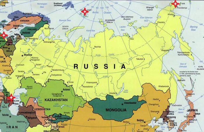
Russia directly borders on 14 independent states, as well as on two partially recognized countries (Abkhazia and South Ossetia). An interesting fact: about 75% of the country's territory is located in Asia, but almost 80% of Russians live in its European part. Total population of Russia: about 147 million people (as of January 1, 2017).
Physical and geographical position of Russia
The entire territory of Russia is located within the Northern Hemisphere of the Earth and almost all (with the exception of a small part of the Chukotka Autonomous Okrug) - within the Eastern Hemisphere. The state is located in the northern and central part of Eurasia and occupies almost 30% of Asia.
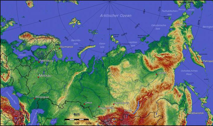
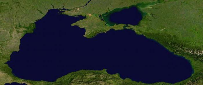
From the north, the shores of Russia are washed by the seas of the Arctic Ocean, and in the east - by the Pacific. In the western part, it has access to the Black Sea, which belongs to the Atlantic Ocean basin. The country has the longest length of any country in the world. coastline- over 37 thousand kilometers. These are the main features of the physical and geographical position of Russia.
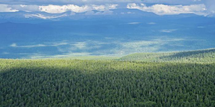
The country has a colossal wealth and diversity natural resource potential... Its vast expanses are home to the richest oil and gas fields, iron ore, titanium, tin, nickel, copper, uranium, gold and diamonds. Russia also possesses enormous water and forest resources. In particular, about 45% of its area is covered with forest.
There are others worth highlighting. important features physical and geographical location of Russia. So, most of the country is located north of 60 degrees north latitude, in the I zone, millions of people are forced to live in these difficult natural and climatic conditions. All this, of course, left its mark on the life, culture and traditions of the Russian people.
Russia is in the area of so-called risky farming. This means that the successful development of agriculture in most of it is difficult or impossible. So, if in the northern regions of the country there is not enough heat, then in the southern regions, on the contrary, there is a deficit of moisture. These features of Russia's geographical position have a noticeable effect on the agro-industrial sector of its economy, which is in dire need of government subsidies.
Components and levels of the country's economic and geographical position
These are, perhaps, the main features of the geographic location of Russia of an economic nature. How has it changed in recent decades? And has it changed?
After the collapse of the USSR, the country's economic and geographical position deteriorated markedly. And above all transport. After all, Russia's access to the strategically important waters of the Black and Baltic Seas in the early 1990s was significantly limited, and the country itself was several hundred kilometers away from the highly developed states of Europe. In addition, Russia has lost many of its traditional sales markets.
Geopolitical position of Russia
Geopolitical position is the place of the country in the world political arena, its relations with other states. In general, Russia has ample opportunities for economic, political, military, scientific and cultural cooperation with many countries of Eurasia and the planet.
However, these relations are not developing in the best way with all states. So, in last years Russia's relations with a number of NATO countries - the Czech Republic, Romania, Poland, which were once close allies Soviet Union... This fact, by the way, is called the largest geopolitical defeat of the Russian Federation in the new century.
Russia's relations with a number of post-Soviet states remain complex and rather tense: Ukraine, Georgia, Moldova, and the countries of the Baltic region. The geopolitical position of the country changed significantly in 2014 with the accession Crimean peninsula(in particular, in the Black Sea region).
Changes in the geopolitical position of Russia in the twentieth century
If we look at the twentieth century, then the most tangible change of power in the European and world political arena took place in 1991. The collapse of the powerful state of the USSR entailed a number of fundamental changes in the geopolitical position of Russia:
- more than a dozen young and independent states with whom it was necessary to establish a new type of relationship;
- the Soviet military presence was finally eliminated in a number of countries in Eastern and Central Europe;
- Russia received a rather problematic and vulnerable enclave - the Kaliningrad Oblast;
- The NATO military bloc gradually approached directly to the borders of the Russian Federation.
At the same time, over the past decades, fairly strong and mutually beneficial ties have been established between Russia and Germany, China, Japan, and India.
As a conclusion: Russia in the modern world
Russia occupies a vast territory, possessing colossal human and natural resource potential. Today it is the largest state on the planet and an important player in the global arena. The most important features of the geographical position of Russia can be identified, here they are:
- The vastness of the occupied space and the enormous length of the borders.
- Stunning variety natural conditions and resources.
- Mosaicity (unevenness) of settlement and economic development of the territory.
- Ample opportunities for trade, military and political cooperation with various neighboring states, including the leading economies of the modern world.
- The volatility and instability of the country's geopolitical position over the past decades.
The peculiarities of the geographic location of Russia are extremely advantageous. But it is important to learn how to use these benefits (natural, economic, strategic and geopolitical) correctly and rationally, directing them to increase the power of the country and the well-being of its citizens.
Russia is largest country the world (1/8 of the land). The area of Russia is 17.1 million km 2, which is almost twice as much as the PRC or the USA. Russian territory comparable to the whole mainland - South America.
Russia accounts for 77% of the territory and 53% of the population of the CIS countries.
In terms of population, Russia is in seventh place after China, India, USA, Indonesia, Brazil and Pakistan.
Russia is located in the northern part of Eurasia, with the European part accounting for about 1/3, and the Asian part - 2/3 of the country's territory.
The length of Russia from west to east is about 9 thousand km. The westernmost point of the Russian Federation is near the city of Kaliningrad (38 ° 38 "E), the extreme east point on about. Ratmanov (169 ° 02 "W), on the mainland - Cape Dezhneva (160 ° 40" W). Consequently, almost the entire territory of the Russian Federation is located in the Eastern Hemisphere. There are 11 time zones within Russia.
Extreme north point countries - m. Fligeli on about. Rudolph as part of arch. Franz Josef Land (81 ° 50 "N), on the mainland - Cape Chelyuskin (77 ° 43" N). Extreme southern point- on the border with Azerbaijan, on the crest of the Main Caucasian Range (41 ° 10 "N).
Thus, Russia is located mainly in temperate latitudes, although the northern part of the country is located in the harsh arctic, and a small section of the Black Sea coast is in subtropical latitudes. The geographical position determines the exceptional severity of natural conditions: about 64% of the territory falls on regions with permafrost soils (Russia accounts for 1/2 of the planetary zone of the North), everywhere in winter precipitation falls in the form of snow.
The total length of borders is 58.6 thousand km, of which only 14.3 thousand km are land, and 44.3 thousand km are sea.
The sea borders in the north and east are 12 nautical miles (22.7 km) from the coast, and the border of the Russian maritime economic zone is 200 nautical miles (about 370 km).
By land, Russia borders in the northwest with Norway and Finland, in the west and southwest - with Estonia, Latvia, Belarus, in the south - with Georgia, Azerbaijan, Kazakhstan, Mongolia, China, in the southeast - with the DPRK.
Most of the maritime boundaries run in the north, along the waters of the seas of the Arctic Ocean and in the east - along the seas of the Pacific Ocean. In the north, Russia borders on the USA, Canada, in the east - on the USA and Japan. In the west there are sea borders with Sweden, Poland, Germany and other Baltic states, in the south - with Ukraine, Georgia (along the waters of the Azov and Black Seas). The borders with Azerbaijan and Kazakhstan pass through the waters of the inland Caspian Sea. Before the collapse of the USSR, Russia bordered only on seven foreign states, and the borders with Ukraine, Belarus, Kazakhstan, etc. within the former USSR were internal. The borders that coincide with the borders of the USSR are for the most part enshrined in international treaties, they are equipped with border outposts and customs, and are guarded by border troops. A significant part of the borders with the CIS states does not yet possess all the attributes inherent in the state border, and is sufficiently "transparent" for the penetration of people and goods. This situation, unfortunately, damages the country's economy and poses a threat to its security.
BUDGET STATE EDUCATIONAL INSTITUTION
SECONDARY PROFESSIONAL EDUCATION
"COLLEGE OF HUMANITARIAN AND SOCIO-PEDAGOGICAL DISCIPLINES NAMED AFTER SAINT ALEXI, MITROPOLIT OF MOSCOW"
by discipline: "Geography"
Togliatti, 2014
Bibliography
1. Favorable and unfavorable features of the Russian state enterprise. Their opportunities for the development of the country
Russia is located in the east of Europe and in the north of Asia, occupying about 1/3 of the territory of Eurasia. The European part of the country (about 23% of the area) includes territories to the west of the Ural Mountains (the border is conventionally drawn along the Urals and the Kumo-Manych depression); The Asian part of Russia, occupying about 76% of the territory, lies to the east of the Urals and is also called Siberia.
The northernmost point of Russia is Cape Fligeli on Rudolf Island in the Franz Josef Land archipelago (81 ° 51 With. lat.), the easternmost point is Ratmanov Island in the Bering Strait (western of the two Diomede Islands, 169 ° 0 h. etc.). The extreme northern and eastern mainland points of Russia: Cape Chelyuskin on the Taimyr Peninsula (77 ° 43 With. sh.) and Cape Dezhnev in Chukotka (169 ° 39 h. etc.). Data extreme points are at the same time the corresponding extreme points of Eurasia. The southernmost point of Russia (41 ° 11 With. sh.) is located south-west of Mount Bazarduzu, on the border of Dagestan with Azerbaijan. The westernmost point lies in the Kaliningrad region at 19 ° 38 v. etc., on the Baltic Spit of the Gdansk Bay Baltic Sea; but the Kaliningrad region is an enclave, and the main territory of Russia begins to the east, at 27 ° 17 v. d., on the border of Russia with Estonia, on the banks of the Pedja River.
Eastern border Russian maritime. It passes through the water expanses of the Pacific Ocean and its seas - the Japanese, Okhotsk and Bering seas. Here Russia borders on Japan and the United States. The border runs along more or less wide sea straits: with Japan - along the La Perouse, Kunashirsky, Treason and Soviet straits, separating the Russian islands of Sakhalin, Kunashir and Tanfilyev (Malaya Kuril ridge) from Japanese island Hokkaido; with the United States of America in the Bering Strait, where the Diomede Islands group is located. It is here, along a narrow (5 km) strait between Russian island Ratmanov and the American island of Kruzenshtern passes the state border of Russia and the United States.
Almost along its entire length, the western border does not have distinct natural boundaries. It starts on the coast Barents Sea from Varangerfjord and passes first along the hilly tundra, then along the valley of the Pasvik river. In this section, Russia borders on Norway. Further, Finland is Russia's neighbor. The border goes along the Manselka Upland, through a very swampy area, along the slope of the low Salposelka ridge and 160 km south-west of Vyborg comes to Gulf of Finland... In the extreme west, on the shores of the Baltic Sea and its Gdansk Bay, is the Kaliningrad region of Russia, which borders on Poland and Lithuania. Most of the region's border with Lithuania runs along the Neman (Nemunas) and its tributary, the Sheshupe River.
Southern border predominantly land. It starts from Kerch Strait connecting the Azov Sea with the Black Sea, and passes through the territorial waters of the Black Sea to the mouth of the Psou River.
Further, the border of Russia runs along the water area of the Caspian Sea, from the coast of which, near the eastern edge of the Volga delta, the land border of Russia with Kazakhstan begins. It passes through the deserts and dry steppes of the Caspian lowland, in the area of the junction of the Mugodzhars with the Urals, along the southern steppe part Western Siberia and in the mountains of Altai.
The northern border, like the eastern one, is maritime. She walks along the seas of the Arctic Ocean.
Russia is washed by 13 seas belonging to three oceans; Moreover, southern part east coast Kamchatka, eastern and southeastern shores of most Kuril Islands washed directly By the Pacific Ocean, that part of it, which is not included in any sea, as well as the internal Caspian Sea. The three seas belong to Atlantic Ocean(Black, Baltic, Azov), six - to the Arctic (Barents Sea, White Sea, Kara Sea, Laptev Sea, East Siberian, Chukchi) and three more to the Pacific (Bering, Okhotsk, Japanese).
The northern part of Russia lies beyond the Arctic Circle, in a cold heat belt... The rest of Russia is located in the northern temperate heat zone.
So, Favorable
Eurasian position;
Land border;
Access to 13 seas of three oceans;
The largest territory in the world;
Leading place in natural resources;
Predominance temperate zone;
Common economic space.
Unfavorablefeatures of the geographic location of Russia:
/ 3 territories - 80% of natural resources in the Asian part of little suitable for life;
Transport problems;
Unevenness of settlement and economy;
Remoteness of the eastern regions;
Deterioration of GP with the collapse of the USSR.
The influence of the geographical location and size of the territory on the peculiarities of nature and the economy of the country.
The main features of its nature are associated with the geographical location of Russia. Russia - northern countries... Our Motherland is a country of forests and tundra, a country of snows and permafrost, the country is coastal, but its shores are washed mainly by cold, ice-covered northern seas.
Russia is located in the harshest north-eastern part of the vast mainland. On its territory there is a cold pole of the Northern Hemisphere. Russia is open to the cold breath of the Arctic Ocean. Most of its territory lies north of 60 ° N. sh. These are the polar and polar regions. South of 50 ° N. sh. only about 5% of the territory of Russia is located. 65% of the country's territory is located in the permafrost zone.
This northern territory has about 150 million inhabitants. Nowhere in the world, not in the north, not in southern hemisphere, there is no such congestion of people in such high latitudes.
The northern specificity of the country leaves a certain imprint on the living conditions of people and the development of the economy. First of all, this manifests itself in the need to build insulated dwellings, heat housing and production facilities, provide stall housing for livestock (and this is not only the construction of special livestock buildings, but also the procurement of feed), create special equipment in the northern version, snow removal equipment for clearing transport highways, streets and sidewalks, spend additional supplies of fuel for work Vehicle at low temperatures... All this requires not only the organization of special production facilities, but also huge material resources, primarily energy consumption, which ultimately leads to colossal monetary investments.
The nature of our country creates great restrictions on the development of agriculture. Russia is in the zone of risky farming. Lack of heat for the development of agricultural crops, and in the southern part - moisture leads to the fact that crop failures and crop failures are a common phenomenon for our agriculture. Major crop failures occur every decade. This requires the creation of significant state grain reserves. The harsh conditions limit the ability to grow high-yielding forage crops. Instead of rather heat-loving soybeans and corn, we have to grow mainly oats, which do not yield such high yields. This, along with the cost of keeping livestock in stalls, affects the cost of livestock products. Therefore, without state support (subsidies), the agriculture of our country, achieving self-sufficiency, is capable of ruining the entire country: all related industries and, above all, its main consumer - the population.
Thus, the northern position of Russia determines the complexity of the entire economy of the country and the high consumption of energy resources. To maintain the same standard of living as in Western Europe, we need to spend 2-3 times more energy than European countries. Only in order to survive one winter without freezing, each resident of Russia, depending on the area of his residence, needs from 1 to 5 tons of standard fuel per year. For all residents of our country, this will amount to at least 500 million tons ($ 40 billion at modern world fuel prices).
2. The relief of Russia. The variety of relief and the reasons for its diversity
Relief - a set of irregularities earth surface... There are two main landforms: plains and mountains. Plains are a form of relief with small (up to 200 m) differences in relative heights. Mountains are a form of relief with large (over 200 m) differences in relative heights. Relative elevation is the elevation of one point on the earth's surface over another, while absolute elevation is the elevation of a location above sea level.
Most of Russia is occupied by plains. The mountains are located mainly in the south and east of our country, which leads to a general slope of the territory of Russia to the north.
The formation of the relief is influenced by internal and external forces. First of all, the main landforms depend on the tectonic structure of the territory. For platform areas - ancient Russian and Siberian platforms or the young West Siberian plate - plains are characteristic: the East European Plain, the Central Siberian Plateau and the West Siberian<#"justify">geographic location russia climate
High mountains- these are mountains with absolute heights of more than 5000 m (Greater Caucasus<#"center">3. Adverse events related to climate and their causes. Areas of their distribution and their impact on human life and activities
Climate<#"center">4. Rivers of Russia. Influence of climate on the regime of rivers in the country
Russia has significant reserves of fresh water. Most widely in national economy river waters are used. Within Russia, there are about 3 million rivers with a total length of almost 10 million km. In terms of the total river flow, Russia is in second place in the world after Brazil<#"center">5. Objects of the World natural heritage in Russia Samara region
In Russia, the first to receive the status of an object world heritage natural complex "Virgin Komi Forests" (December 1995). By the end of 1996, the objects "Lake Baikal" and "Volcanoes of Kamchatka" were included in the List, and in 1998 another Russian natural complex- "Altai - Golden Mountains". In December 1999, at the XXIII session of the World Heritage Committee, a decision was made to include the fifth Russian natural site, the Western Caucasus, on the List. Among the territories that are promising from the point of view of their inclusion in the List in the near future are the national complexes of the reserves "Astrakhansky", "Daursky", "Magadansky", "Chernye Zemli" and Meshchersky national park.
.The Virgin Komi Forests.
2.Lake Baikal.
.Volcanoes of Kamchatka.
.Western Caucasus.
5.National park"Vodlozersky" (The Vodlozero National Park).
6.The Bashkirian Urals.
7.The Ubsunur Hollow.
8.Central Sikhote-Alin.
.Delta of the Lena (The Delta of the Lena).
10.The Curonian Spit.
11.The Green Belt of Fennosgandia.
12.The Putorana Plateau.
13.Kuril Islands (The Commander Islands).
14.The Valdai Upland.
Samara region is located in the middle reaches the greatest river Europe - the Volga, on both sides. The region covers an area of about 54 thousand square kilometers. In the north-west, it borders on Ulyanovsk, in the south - on Saratov, in the east - on the Orenburg regions, and in the north - on the Republic of Tatarstan. In terms of its area, the Samara region is larger than such European states like Denmark, Belgium and Holland. Most of the region's territory (91.9%) lies on the left bank and is called the Trans-Volga region. The smaller part is located on the right bank, or in the Volga region. Within the region there are two huge artificial seas- Kuibyshev and Saratov reservoirs.
The region occupies a convenient geographical position. It is located at the intersection of the greatest waterway and railways connecting Siberia, the Urals, Far East and Central Asia With central regions country.
The nature of the Samara region has many peculiar and curious features. There are about 306 natural monuments on the territory of the region, and 13 of them are republican significance... Within the region, the Volga makes a large bend, forming the Samara Luka. The famous Zhigulevskie mountains stretch along the northern part of the Volga bend - one of the most scenic spots throughout the East European Plain. The right bank is an elevated area. This includes the Volga Upland with the Zhigulevsky Mountains.
The left bank is divided by the nature of the relief into Low, High and Syrtovoe Zavolzhye. The low-lying Trans-Volga region is an ancient Volga terrace stretched along the bed of the modern river. Volga. High Trans-Volga region is located north of the river. Samara and east of the river. Kondurchi and has the highest marks reaching 347 m absolute height... South of the r. Samara stretches the Syrtovoe Zavolzhye, which is a plain with flat-convex rallies - syrts. The most notable place region is Samarskaya Luka. The mountainous, highly dissected relief, deep valleys overgrown with dense vegetation, cliffs and rocks composed of limestones and dolomites, original peaks and mounds made Zhiguli a wonderful corner of the Volga region, valuable not only aesthetically, but also scientifically. Since the Quaternary glacier did not enter the territory of modern Samarskaya Luka, rare species of plants and animals of the preglacial period have survived here. That is why the Zhiguli State Reserve was created within the Zhiguli in 1927. On the rest of the Samarskaya Luka in 1984 the State Natural National Park "Samarskaya Luka" was formed, the western border of which is the Usinsky Bay.
The Samara region lies on the border between the forest and the steppe, and its territory is located in two natural areas- forest-steppe and steppe. Protective forest belts stretch for hundreds of kilometers across the Trans-Volga steppe. They have a beneficial effect on the climate and soil cover, protecting it from the destructive effects of erosion.
At the moment, a unique network of various specially protected natural areas has been formed in the Samara region. It is based on protected areas of federal significance Zhigulevsky state nature reserve named after I.I. Sprygina (23.157 thousand hectares), National Park C "Samarskaya Luka" (127.186 thousand hectares), National Park "Buzulugsky Bor" (54.102 thousand hectares) Their area is 3.8% of the total area of the Samara region.
The reserve is located in the Middle Volga region in the most elevated part of the Samarskaya Luka, called the Zhigulevsky mountains, in the western part of the Samara region, on the territory of the Stavropol administrative region.
The greatest length from north to south is 13 km, and from west to east - 29 km. The total area of the reserve is 23157 hectares.
The value of the reserve, located on Samarskaya Luka, is determined by its peculiar geological past, unique landscape and geographical location at the junction of various zones and provinces. These factors determined the high biological diversity of the territory, habitats of 50 relict and endemic plant species and 50 animal species listed in the Red Book of the Russian Federation are preserved here.
The reserve has revealed 9 types, 13 subtypes, 86 varieties, as well as 18 soil complexes, Largest area are occupied by soddy-calcareous soils (42.5%) and gray forest soils (38.2%).
The reserve is especially distinguished by the diversity of flora and fauna. In terms of the richness of taxa, among plants, flowering plants are distinguished, numbering 1036 species, and among animals - invertebrates (4654 species). Many representatives of biota in the reserve and on Samarskaya Luka are relics of various geological epochs, are of significant conservation interest, since they are included in the Red Data Books of various ranks or are rare in Eastern Europe.
The floristic composition of vascular plants of the reserve is estimated at 1118 species, of which: bryophytes - 127 species, higher spore plants - 22, gymnosperms - 3, flowering - 1036 species. 141 species of flora of the reserve are included in the Red Data Book of the Samara Region.
The main zonal types of vegetation cover of the reserve are deciduous forests, represented by Central Russian-Volga linden forests with an admixture of other deciduous species (oak, maple, elm, elm, etc.) and broadleaf-pine and pine grass-grass steppe forests. A smaller area is occupied by stony and shrub steppes, meadow steppes, dry and floodplain meadows.
The reserve contains about 80% (226 species) of the avifauna of the Samara region. Most of them (141 species) live on the territory or along the boundaries of the reserve in different seasons or permanently (125 - nesting and sedentary, 16 - flying and wintering), the rest of the species are migratory or migratory (31.4%). Characteristic avifauna - a large number of species of daytime predators and a high number of representatives of deciduous forests (white collar flycatcher, small flycatcher, gray-headed woodpecker, white-backed woodpecker, blackbird, black-headed warbler).
The reserve has 60 species of birds, rare for the Samara region, among them 10 species are included in the Red Data Books of various ranks.
The modern composition of the mammalian fauna is characterized by 48 species of animals from 6 orders, 15 families and 34 genera, which is approximately 63% of the species composition of this group of the Samara region and 54% of the Volga-Kama region.
The role of the reserve in the conservation of mammals is extremely important. Over 77% of the theriofauna of the right bank of the Samara region is typical for the territory of the Zhigulevsky reserve, and the representativeness for the entire Samarskaya Luka increases to 92%. Bats (79% of the diversity of the Volga-Kama Territory and 85% of the Samara Region), carnivores (59% and 67%, respectively) and rodents (39% and 50%, respectively) are represented most completely in the theriological complex of the reserve.
The Samarskaya Luka National Park is a clearly marked natural site of outstanding universal value from the point of view of science, nature protection and beauty.
The national park occupies eastern part Zhigulevskaya Upland, washed from the west by the Usinsky Bay of the Kuibyshev Reservoir, and from the north, east and south by the giant bend of the Volga River. The width of the peninsula is about 30 km, the length is 60 km, and the area is 160.5 thousand hectares. The national park occupies 79.8% of this territory, the Zhigulevsky reserve - 5.8%. The narrow Perevoloksky Isthmus (2.1 km) connects the peninsula with the mainland. For the most part, the park's border is natural - it runs along the water area along the right bank of the Volga bend. Only in three places does it move away from the water: when it bends around the village of Yablonovy Ravine, the city of Zhigu-levsk and the Zhigulevsky nature reserve. The park also includes two isolated territories - the Mordovin Islands and Mogutova Gora. The area of the park is 128 thousand hectares.
About half of the national park is covered with forests (51.3%), mostly deciduous. Pine forests are found mainly in the mountainous part in the form of miniature pine forests.
Mainly, middle-aged forests dominate with the dominance of one of the species: linden, aspen, maple. Hayfields and pastures occupy 12% of the park's territory, and arable wedge - about 27.6%.
On the border of two regions - Orenburg and Samara - in the floodplain of the Samara River and its tributaries - the Borovka and Koltubanka rivers - on the first and second above-floodplain terraces there is Buzuluk Bor - a unique forest area.
The pine forest area in the Samara region is 54.102 thousand hectares. The total area of coniferous stands reaches 50% of the total pine forest area. More than two-thirds of the massif is occupied by various pine and mixed forests... The pine forest is bordered on all sides by a strip of deciduous forest bordering the treeless steppe.
Buzuluk forest - eighty thousand hectares of sand binds the forest with roots. Pine stands of the forest are an active factor in the inhibition of wind erosion in the surrounding areas. By contributing to rainfall and the accumulation of snow, favoring the transfer of surface melt water to groundwater, boron restrains water erosion of soil and regulates water reserves in the basins of the Borovka, Chertakly, Mushtai, Koltuban, Taneevka and others rivers.
More than 50 species of trees and shrubs, 600 species of grasses, mosses and lichens grow in the forest. The bora fauna is represented by 225 species of vertebrates, of which: 44 mammals, 135 nesting birds, 15 species of reptiles and amphibians, 24 species of fish.
Endangered species are desman, bat, giant nocturnal, black stork, eagles golden eagle and eagle - burial ground, falcons saker falcon and peregrine falcon, which are listed in the Red Book Russian Federation... The wolf, weasel, ermine, badger are very rare. Beavers, muskrats, lynxes, and minks have settled quite widely in the forest.
6. Make a description arctic deserts and the tundra of Russia (according to plan), proving that they are large natural-territorial complexes (NTC)
This climatic region contains the arctic desert zones.<#"justify">Physical and geographical regionalization. Any NTC is the result of a more or less long-term development. Scientists record slow tectonic movements, secular climate changes, advancing and retreating seas, etc. Even a person who has lived a long life does not have time to notice these changes.
Smaller PTCs are distinguished by a special variety. Various geological structure, variety of topography and climate<#"334" src="doc_zip1.jpg" /> <#"justify">1.Russian (East European) plain.
2.North Caucasus.
Ural.
.West Siberian lowland, or plain.
Central Siberia.
.North-East of Siberia.
.Belt of mountains of Southern Siberia.
Far East.
Thus, it can be seen from Fig. 1 that the Arctic deserts and tundra of Russia are large natural-territorial complexes
Bibliography
1.Vasilyeva D.I., Baranova M.N. Natural resources Samara region, Samara, 2012.
2.Geography: grades 8-9, "1C" (electronic supplement to the textbook of geography of Russia).
.Dronov V.P., Barinova I.I., Rom V.Ya., Lobzhanidze A.A. - Book 1: Geography of Russia: Nature, population, economy. 8 class. - M .: Bustard, 2011.
.Neklyukova N.P., Dushina I.V., Rakovskaya E.M. and other Geography: a reference book for high school students. - M .: AST-PRESS SCHOOL, 2008
.Parmuzin Yu.P., Karpov G.V. Dictionary of Physical Geography. - M .: Education, 2010.
.Plisetskiy E.L. Commercial geography. Russia and the world market. In 2 volumes - M .: AST-PRESS SCHOOL, 2012
.Rakovskaya E.M. Geography of Russia. 8 grade. Moscow: Education, 2010
.Uchaikina I.R., Lopukhov N.P., Voronin V.V. Geography of the Samara region. Tutorial for students in grades 8-9. - Samara, 2009
9.
Http://geographyofrussia.com/fizicheskaya-geografiya.html
Work order
Our experts will help you to write a paper with a mandatory check for uniqueness in the "Antiplagiat" system
Send a request with requirements right now to find out the cost and the possibility of writing.
Geographical location includes three components - physical and geographical location, economic and geographical location and and means the peculiarities of the location of a country or other geographic feature on physical, economic and.
A serious issue is relations with Muslim states on the southern borders of Russia, as well as with the countries of the South.
As a result of the collapse of the USSR, the length of Russia's borders is now 60,933 km. Thus, almost 2/3 of Russia's borders are maritime. Our country has the longest land border with Kazakhstan (41% of the entire land border of Russia), (about 20%) and (10% of the land border of Russia).
Assessing the geographical position of the country, one cannot ignore such a concept as "vastness". Russian territory is enormous. There are countries that you can walk in a few hours (,). You can travel by car in a day,. You can cross Russia from west to east in a day only by plane.
Unfortunately, our age of high speeds has changed the previous perception of space and distance. In the XIX century. French writer Germaine de Stael wrote about the spaces of Russia: “Russia is the threshold of another, unknown land of the East. In Russia there is such space that everything in it is lost, even palaces, even the population itself. Everything drowns in an immense space, it reigns over everything and captures the imagination. "
The territory of Russia is difficult to imagine also because there are no countries in the world that are similar in size to it. For example, the area of the United States (9.4 million km2) is 55% of the area of Russia, and the area of all states overseas Europe- 35% of the area of our country.
1% of the territory of Russia (for example, republics, Tuva) is the area of countries such as or; 2% (for example, the Republic of Buryatia, Amur region) - it