World War I 1914-1918, February and October revolutions of 1917 in Russia led to a change political map Europe. The Second All-Russian Congress of Soviets of Workers 'and Soldiers' Deputies on October 25 (November 7) 1917 announced the transfer of power in Russia into the hands of the Soviets. The III United All-Russian Congress of Soviets of Workers', Soldiers' and Peasants' Deputies on January 10-18 (23-31), 1918, proclaimed the creation of the Russian Socialist Federative Soviet Republic (RSFSR), which was legally enshrined in the Constitution (Basic Law) of the Russian Socialist Federative Soviet Republic, adopted by the V All-Russian Congress of Soviets on July 10, 1918. On March 12, 1918, after the government of the RSFSR moved from Petrograd, Moscow became the capital of the RSFSR. As a result of the conclusion on March 3, 1918, Russia of a peace treaty (Peace of Brest-Litovsk) with Germany and its allies (Austria-Hungary, Bulgaria and Turkey) in the city of Brest-Litovsk annexed Poland, the Baltic States, part of Belarus; Part of the Transcaucasus (districts of Ardahan, Kars and Batum) was ceded to Turkey. According to the terms of the agreement, the RSFSR recognized the independence of Finland and Ukraine. In the course of what began soon civil war on the territory of the former Russian Empire the independent Poland, the Transcaucasian (Armenia, Georgia and Azerbaijan) and the Baltic (Lithuania, Latvia and Estonia) republics were formed. On December 12 (25), 1917, the Ukrainian Socialist Soviet Republic was proclaimed (actually formed in March 1919). On January 1, 1919, the Byelorussian SSR was formed (in February it became part of the Lithuanian-Byelorussian SSR, which existed until August 1919, the Byelorussian SSR was restored in July 1920). Bessarabia was occupied by Romania in 1918, and Western Ukraine and Western Belarus became part of Poland.
Czechoslovakia was rescued to ease Western fears over the fate of Poland. Securing Soviet control over Poland was Stalin's main concern, and the pseudo-co-collimation ruled there from the very beginning. Stalin's post-war strategy in Western Europe was different. He ordered the European communist parties to foment workers' strikes in order to undermine political structures and economies.
Relations with foreign communist movements
Eastern European foreign ministers were summoned to Moscow, reprimanded, and ordered not to accept aid from the United States. The Soviet Union supported only those foreign communist movements that Moscow could control. However, almost every communist movement that has succeeded in substance, without direct or indirect support Soviet Union, had a strongly nationalistic component, incompatible with Soviet hegemony.
During the civil war and foreign intervention (1918-1920), several dozen national-state formations were proclaimed on the territory of Russia, most of which existed from several months to a year.
On the territory of the former western outskirts of Russia, new states were formed, the borders with which were soon secured by the peace treaties of the RSFSR with Estonia (February 2, 1920), Lithuania (July 12, 1920), Latvia (August 11, 1920), Finland ( October 14, 1920), Poland (March 18, 1921). The position of the border of the RSFSR with Romania remained unsettled, since it did not recognize the forcible capture of Bessarabia by Romania in 1918.
Stalin also had problems with the Chinese communists. Stalin continued to provide economic aid to the Chinese in the hope of securing Chinese dependence, but relations continued to be marked by distrust. The situation in China was a foreign policy defeat for Stalin, because he could never be sure that eastern border The Soviet Union will be safe.
They united their zones of occupation in anticipation of German statehood, an unification to which Stalin strongly objected. He challenged Germany's Western plans by taking advantage of Berlin's isolation, eighty miles from the Soviet zone of occupation. This was followed by a reduction in electricity, coal and food in the city. The Anglo-American powers immediately began air transportation needed for supplies to Berlin, which lasted until Stalin lifted the blockade in May. The failure of the Berlin blockade was an acute embarrassment to the Soviet government.
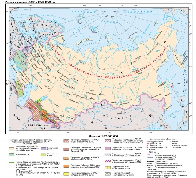
On April 22, 1918, the Transcaucasian democratic republic... However, under the influence of factors of internal and foreign policy it soon disintegrated into the Armenian, Azerbaijan and Georgian bourgeois republics. In 1920-1921. on their territories, respectively, the Armenian, Azerbaijan and Georgian SSRs were created. In Central Asia, the Khorezm People's Soviet Republic (Khorezm NSR) (April 26, 1920) and the Bukhara NSR (October 8, 1920) were created.
Berlin served as an exit from the Soviet occupation zone for 6 million Germans. The stand was considered a symbol of Western determination and competence in the face of ruthless Soviet models. However, he immediately ordered his scientists and those captured from Nazi Germany to redouble their efforts to promote division.
Disappointed with economic recovery Western Europe By the failure of the Berlin blockade and the US presence in Japan, he strongly encouraged, if not ordered, the North Korean communist government to invade the non-communist South. Approaching a swift victory, the North Koreans were greeted by a swiftly formed United Nations force, consisting mostly of American troops. The S. forces counterattacked and advanced towards the Yalu River near the Manchu border.
Changes have also taken place in eastern Russia. After the landing in the city of Aleksandrovsk on April 22, 1920, the Japanese troops occupied the northern part of Sakhalin Island, where power passed into the hands of the Japanese military administration. The Uryankhai Territory departed from Russia, on the territory of which the People's Republic of Tannu-Tuva was proclaimed. In Transbaikalia and the Far East on April 6, 1920, the Far Eastern Republic was formed.
Stalin did receive some benefits from the Korean War: the United States had to send large numbers of troops to the peninsula, troops that might otherwise have been used to thwart Soviet attempts to Eastern Europe... In addition, the Chinese became more dependent on the Soviet military equipment and from the Soviet Union itself, thereby delaying a possible split between the two countries.
From now on, military considerations will prevail over political ones in Washington. Accordingly, the newly created North Atlantic Treaty Organization will be strengthened, which will soon include the military forces of a redesigned West Germany.
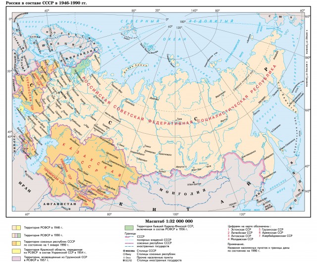
As a result of the changes that took place, by the beginning of 1922, most of the territory of the former Russian Empire was occupied by the Russian Socialist Federative Soviet Republic (RSFSR). Formally independent were the Ukrainian SSR, the Byelorussian SSR, the Armenian SSR, the Georgian SSR, the Azerbaijan SSR, the Khorezm NSR, the Bukhara NSR and the Far Eastern Republic. On March 12, 1922, the Azerbaijan, Armenian and Georgian SSR united into the federal Union of Socialist Soviet Republics of the Transcaucasus, on December 13, 1922, transformed into the Transcaucasian Socialist Federal Soviet Republic. On November 15, 1922, the Far Eastern Republic merged with the RSFSR.
Stalin's successors began negotiations to end the war shortly after his death. V last years Stalin ruled more autocratic than ever. He appointed small groups of consultants known as sextets or quartets to study specific problems and then presented his recommendations to him. By assigning more than one group to study the same problem, he was able to play his advisers against each other and prevent any coordinated opposition from emerging.
The show processes that marked the "Great Purge" were revived, the last victims were those who were accused of involvement or sympathy with Titosta. This accusation, undoubtedly, was false, it was supposed to serve as a pretext for another purge in order to eliminate more colleagues whom Stalin came with suspicion - Anastas Mikoyan, Lavrenty Beria and Molotov would have been there.
On December 30, 1922, the I Congress of Soviets of the USSR proclaimed the formation of the Union of Soviet Socialist Republics (USSR) as part of the Russian Socialist Federative Soviet Republic of the RSFSR, the Ukrainian Socialist Soviet Republic (Ukrainian SSR), the Belarusian Socialist Soviet Republic (BSSR) and the Transcaucasian Socialist Federative Soviet Republic (ZSFSR) - Georgia, Azerbaijan, and Armenia). The largest in area of the RSFSR included, in addition to the European part of the RSFSR, Siberia, Far East, Kazakhstan and Central Asia, except for the Bukhara and Khorezm NSR.
Well known to modern observers, they have been paradoxically little studied, despite the very large number of sources. The article carefully examines the sources and then analyzes the demographic crises in detail. Added to this was the devastation of cholera and typhoid fever spread by the refugee movements most affected by the crises, and famine affected overall impact on mortality, an increase in what was ultimately more important in demographic conditions than the epidemiological effects, even more dramatic.
While modern observers are well known, they are paradoxically rarely studied despite abundant sources. The article examines the causes of the crisis. One of the consequences of the famine was that the number of births fell by 43%, and the peaks in mortality exceeded 100%. In addition to the devastation caused by cholera and typhoid fever, which was spread by the refugee movements most affected by the crises. However, hunger had an overall effect on mortality, due to which all species increased, which ultimately brought more weight in demographic conditions than epidemiological effects, which were, however, more impressive.
The II Congress of Soviets of the USSR approved on January 31, 1924 the Basic Law (Constitution) of the Union of Soviet Socialist Republics.
The Bukhara and Khorezm NSR were transformed into the Bukhara and Khorezm SSR on September 19, 1924 and October 20, 1923, respectively.
Importance demographic crises dissertation was well understood by Western observers of the time. Epidemiology. The logical and demographic stability of Europe from epidemic epidemics was considered so great that intense international efforts were made to monitor and try to limit the spread of this crisis center. Creation of the League of Nations Health Organization. The importance of hunger as it was in the past.
It is therefore surprising that dissertation crises have been little studied by recent historians or historical demographers. The reason for this is not a lack of material. The accompanying map shows the location of Saratov and other famine areas. The next section summarizes the demographic characteristics of the population in this section. Discussion of the main factors associated with hunger and epidemics.
In 1924 and 1926. parts of the territories of the Vitebsk, Gomel and Smolensk provinces inhabited by Belarusians were transferred from the RSFSR to the Byelorussian SSR. In the same period, there were minor changes in the border between the RSFSR and the Ukrainian SSR.
In 1924, the national-state demarcation of Central Asia was carried out. The Bukhara and Khorezm SSRs were liquidated. On their territory and adjacent territories of the Turkestan ASSR, which was part of the RSFSR, on October 27, 1924, the Turkmen SSR and the Uzbek SSR were formed (the latter included the Tajik ASSR, formed on October 14, 1924). At the III Congress of Soviets of the USSR (May 13-20, 1925), these republics were admitted to the USSR. The Tajik ASSR on October 16, 1929 was transformed into the Tajik SSR and on December 5 of this year became part of the USSR. The Kazakh (until April 19, 1925 - Kyrgyz) ASSR remained in the RSFSR. The structure of this autonomous republic, in turn, included the Kyrgyz Autonomous Soviet Socialist Republic (until May 25, 1925 - the Kara-Kyrgyz Autonomous District, until February 1, 1926 - the Kyrgyz Autonomous Region) and the Karakalpak Autonomous Region.
Reliability and availability of statistical and demographic data
Source of Hunger-Suffering Regions: After the Famine, no. This section discusses the reliability of demographic data for Saratov in the context of a brief overview of the reliability of early Soviet statistics in general, of which there are many misconceptions.
Civil war, epidemics and famine undoubtedly caused colossal social and political unrest, but it would be wrong to assume that this led to the complete collection and processing of statistical materials throughout Russia. During the revolutionary period, they formed for the first time in a national organization based on statistical congresses. Despite the difficulties of a period of statistical activity on a scale unprecedented in the history of Russia or elsewhere.
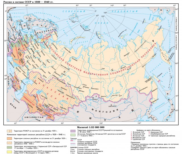
According to the "Convention on the Basic Principles of Relations between the USSR and Japan" signed on January 20, 1925 in Beijing, the 1905 Portsmouth Peace Treaty was restored, and Japan returned the northern part of Sakhalin Island to the USSR.
The XII All-Russian Congress of Soviets approved on May 11, 1925 the Constitution (Basic Law) of the Russian Socialist Federative Soviet Republic.
In those battles that were fought or that temporarily fell into the hands of the enemy, there was, of course, a reasonable disorganization and a gap in the statistical and demographic records. But in many of the provinces that remained in the hands of the Bolsheviks, there was an amazing degree of statistical continuity. Serebryakov remained at the post of head of the Saratov province. The Statistical Bureau during this turbulent period, and Kovalevsky headed the statistics sector of the depography of the Gubstat Bureau.
In terms of census data, the position was very good. The most serious problems were caused by inadequate birth and death registration data and massive population movements during this period. For the city, however, the data was much better. Kovalevsky points out that in order to be eligible to receive rations in Saratov, children had to provide information that they were in Boni in the city, and, therefore, it was very important for parents to register their children.
On May 20, 1926, the Council of People's Commissars of the Union of Soviet Socialist Republics adopted a resolution "On the declaration of the territory of the USSR of the lands and islands located in the Arctic Ocean", according to which all the Arctic islands between the meridians 32 ° 4'35 "east longitude and 168 ° 49 '30 "west longitude were declared the territory of the USSR. In the summer of 1929, a permanent Soviet colony and the world's northernmost research station were organized on Franz Josef Land (Hooker Island). On July 29, 1929, Soviet polar explorers hoisted the USSR flag on the Nile Cape of the Georg Land.
Kovalevsky argues that due to the fact that these children were originally excluded from the registers at the time of their birth, they were eventually recorded. This claim should be treated with some skepticism, since this registration would only apply to those children who were still alive, who were still living in Saratov or were privately buried in the Saratov cemetery. It should be added that those who were still born were not included in the birth or death registers.
With regard to deaths, the data on the settlement population in Saratov was probably almost difficult, because in order to receive a personal burial in the cemetery, it was necessary to obtain a death certificate. However, there have been problems with burials that were carried out by the civil authorities themselves for people who died in hospitals, orphanages, other civilian institutions, or, presumably, simply died in the streets or on railway station, without relatives or friends the necessary measures.
On December 5, 1936, at the Extraordinary VIII Congress of Soviets of the USSR, a new Constitution (Basic Law) of the Union of Soviet Socialist Republics was adopted, according to which all Union republics that existed by that time, as well as the Kazakh and Kyrgyz SSRs transformed from the ASSR, were included in the USSR. The Karakalpak ASSR was transferred from the RSFSR to the Uzbek SSR. The Azerbaijan, Armenian and Georgian SSRs, which had previously been part of the TSFSR, became independent members of the USSR. Thus, by the end of 1936, the USSR included 11 republics: the RSFSR, Azerbaijan, Armenian, Belarusian, Georgian, Kazakh, Kyrgyz, Tajik, Turkmen, Uzbek and Ukrainian Soviet Socialist Republics.
But he claims it was exceptional. For other cases, Kovalevsky assures. Us that the Statistical Section of Statistics in the Statistical Bureau insisted that the relevant authorities could send the data, although this inevitably arrived much later than the bulk of the data from the settler population.
Late data were initially not included in current statistics. But thanks to the work of Kovalevsky and students in the statistical department of Saratov state university and with the financial support of the Research Institute. Gorky in the South of the Volga, these latest data have been revised so that the numbers on death and childbirth can be corrected. With regard to the cause of death, a modified version of the International Classification proposed by Bertillon was used. The cause of death had to be confirmed by a doctor or other physical worker, presumably in most cases by a paramedic.
On January 21, 1937, at the Extraordinary XVII All-Russian Congress of Soviets, the Constitution (Basic Law) of the Russian Soviet Federative Socialist Republic was adopted.
At the beginning of November 1939, according to the decisions of the people's assemblies of Western Belarus and Western Ukraine, these regions were included in the USSR and reunited with the Ukrainian SSR and the Byelorussian SSR.
After the Soviet-Finnish war of 1939-1940. according to the peace treaty between the USSR and Finland, signed on March 12, 1940, the state border between the countries was established along a new line: the entire Karelian Isthmus with the city of Vyborg, the Vyborg Bay and the islands, the western and northern coasts were included in the USSR Lake Ladoga with the cities of Kexholm (now Priozersk), Sortavala and Suoyarvi, islands in Gulf of Finland and other territories. The Karelian Autonomous Soviet Socialist Republic, together with the part of the former regions of Finland that entered it, was transformed on March 31, 1940 into the Karelo-Finnish SSR and thus seceded from the RSFSR. The rest of the districts seceded from Finland became part of the Leningrad and Murmansk regions.
By an agreement of June 28, 1940, the Romanian government peacefully transferred Bessarabia and Northern Bukovina to the USSR, and on August 2, the Moldavian SSR was formed by uniting six districts of Bessarabia (Beltsy, Bendery, Cagulsky, Orhei, Soroka and Kishinev) and the Moldavian ASSR, before that which was part of the Ukrainian SSR. Northern Bukovina and three districts of Bessarabia (Khotinsky, Akkerman and Izmail) were included in the Ukrainian SSR.
At the beginning of August 1940, Lithuania, Latvia and Estonia became part of the USSR as union republics.
As a result, the USSR in August 1940 included 16 union republics.
During the Great Patriotic War and after its end, there were subsequent major changes in the territory of the USSR. Tuvinskaya People's Republic(this is how the People's Republic of Tannu-Tuva was called since 1926) on October 11, 1944, it entered the USSR as an autonomous region within the RSFSR (on October 10, 1961, it was transformed into the Tuva ASSR). At the end of the war, the USSR signed a number of agreements and treaties with Finland, Czechoslovakia, Poland, which included the solution of territorial issues.
Finland, under the armistice agreement of September 19, 1944 and the peace treaty of February 10, 1947, transferred the Petsamo region (Pechenga) to the USSR. According to the Soviet-Czechoslovak agreement of June 29, 1945, the Transcarpathian Ukraine became part of the USSR and was reunited with the Ukrainian SSR.
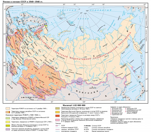
During the Great Patriotic War, there were minor changes in the borders between the Union republics. So, in 1944, Zanarovye and Pechora from the Estonian SSR, the Pytalovsky region from the Latvian SSR, and some territories were transferred to the RSFSR. North Caucasus were transferred from the RSFSR to the Georgian SSR (in 1957 they were returned to the RSFSR).
According to the decision of the Crimean () conference on February 4-12, 1945 and in accordance with the Soviet-Polish agreement of August 16, 1945, the border between the USSR and Poland was established along the so-called "Curzon line", but with a deviation from it by 5-8 km to the east, that is, in favor of Poland. Additionally, Poland was assigned the territory south of the city of Krylov with a deviation to the east of up to 30 km in favor of Poland, part of the territory of Belovezhskaya Pushcha, including the settlements of Nemyriv, Yalovka, Bialowieza, with a maximum deviation in favor of Poland 17 km east of the Curzon line ”. Thus, the Bialystok region of Belarus and the Przemysl (Przemysl) region in Western Ukraine were transferred to Poland.
By the decision of the Berlin (Potsdam) conference on July 17-August 2, 1945, the territory of the USSR was expanded at the expense of a part of East Prussia, which became the Königsberg, then the Kaliningrad region as part of the RSFSR.
Kurile Islands and the south of Sakhalin Island, by the decision of the Crimean Conference, were recognized as the property of the USSR, but were held by Japan. After the USSR declared war on Japan by the beginning of September 1945, the southern part of Sakhalin Island and the Kuril Islands were liberated from Japanese troops, and on February 2, 1946, by a decree of the Presidium of the Supreme Soviet of the USSR, the southern part of Sakhalin Island and the Kuril Islands were declared the property of the Soviet state.
Exploration and mapping of the territory
By 1917, there were many "blank spots" on the map of Russia, especially in Eastern Siberia, Central Asia and the Arctic. In addition, the development productive forces countries required detailed study and mapping natural conditions and resources. Therefore, expeditions to little-explored regions of the country were organized already in the first years of Soviet power.
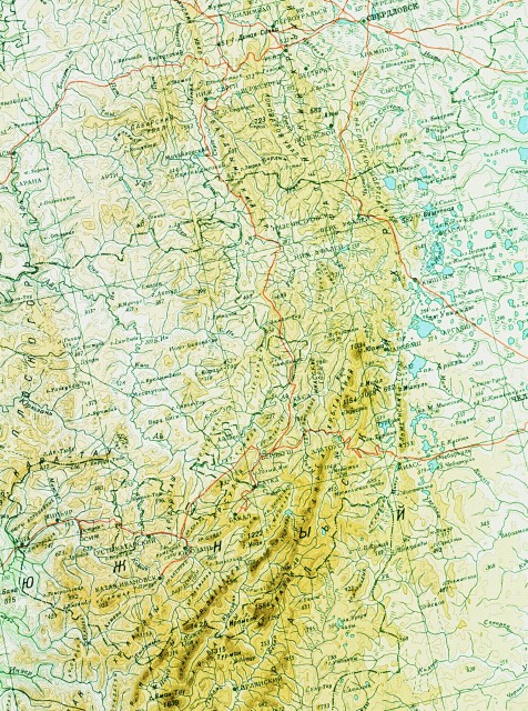
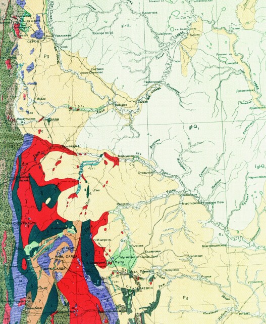
Comprehensive studies of the nature of a number of remote regions of the country, aimed at creating new mineral resource bases, were conducted by expeditions organized by the Commission for the Study of the Natural Productive Forces of Russia, created back in 1915 on the initiative of V.I. Vernadsky, and then (since 1930) by the Council for the Study of the country's productive forces. They led to the discovery of new deposits - copper and iron ore in the Urals, potassium salts in the Urals, apatites in Kola Peninsula, new gold-bearing areas in Siberia, the Volga-Ural oil and gas region. Research in the mountains of the northeastern USSR and other regions of the country significantly changed the previous ideas about the relief and hydrographic network country.
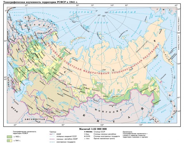
In 1926, the Indigirskaya expedition under the leadership of geologist S. V. Obruchev discovered the mountain system “Chersky ridge” with heights of more than 3000 m (earlier, the lowlands were depicted on the domestic ones). Geodetic and topographic work in the expedition was carried out by K. A. Salishchev, later a famous Soviet cartographer, in 1968-1972 - President of the International Cartographic Association. Through the efforts of the expedition in 1926 and 1929-1930. the first detailed cartographic image is received mountain systems The Chukotka Peninsula and the basins of the Indigirka, Kolyma, Anadyr rivers, the Alazey Plateau is highlighted.
The Soil, Geomorphological, Geological, Botanical Institutes, created at the USSR Academy of Sciences (USSR Academy of Sciences) in the mid-1920s and early 1930s, took over most of the work on the development of new thematic maps - soil, geomorphological, tectonic, geobotanical, etc.
In the 1920s, large studies began in the Arctic, which made it possible to significantly refine the map of this region. As a result of the work of a number of expeditions (1921, 1923-1924, etc.), the outlines of Novaya Zemlya were determined. An expedition of the Arctic Institute under the leadership of G. A. Ushakov and N. N. Urvantsev in 1930-1932 found out the location of the islands of Severnaya Zemlya. It turned out that Severnaya Zemlya is not a single island, but an archipelago of five large (Bolshevik, October Revolution, Komsomolets, Pioner, Schmidta) and many small islands, straits between the islands are open.
A number of unknown islands have been discovered in the Kara Sea. In 1930, an expedition on the icebreaking steamer "Georgy Sedov" under the command of O. Yu. Schmidt discovered the islands of Vize, Isachenko and Voronin; an expedition on the icebreaking steamer "Rusanov" in 1932 - Izvestia TsIK Islands; expeditions on the icebreaking ship "Sibiryakov" in 1932 and 1933 - the islands of the Arctic Institute (Sidorov and Bolshoi). In 1935, a high-latitude expedition on the icebreaking steamer Sadko under the command of GA Ushakov discovered Ushakov's island, completely covered with an ice sheet.
Arctic expeditions discovered new islands and “closed” non-existent ones. Thus, the issue with “Sannikov's Land” and “Andreev's Land” was finally resolved. If the first one (“seen” by the Russian industrialist Y. Sannikov in 1811) simply did not exist, then the land seen by S. Andreev in 1764 turned out to be the island of New Siberia, discovered in 1806.
Soviet polar expeditions clarified the depths and boundaries of the continental shelf, discovered a depth of 5180 m in the central depression of the Arctic Ocean. The drifting expedition "North Pole-1" headed by ID Papanin in 1937 finally established the absence of land in the area of the pole, got an idea of the depths in this area.
For the study and development of the northern seas and their coasts in 1932, the Main Directorate of the Northern Sea Route was founded. The navigation of the icebreaker Sibiryakov (1932-1933) marked the beginning of the development of the Northern Sea Route.
The outlines of the northern coast of Siberia have noticeably changed on the maps, in particular, the outlines of the Gydan Peninsula, Olenek Bay and the Lena Delta, and the Taimyr Peninsula. On the Taimyr Peninsula in 1928-1944 mountains with a height of more than 1000 m were discovered, vegetation and animal world, Lake Taimyr has been comprehensively studied (Taimyr expedition of the Academy of Sciences of the USSR under the leadership of A.I. Tolmachev, 1928, etc.).
In Eastern Siberia, large mountain ranges were identified (Yablonovy, Stanovoy, Dzhugdzhur, Suntar-Khayata), Kolymskoye (Gydan), Chukotka, Koryaksky highlands and Anadyr plateau.
Geysers were discovered in Kamchatka in 1941 south of Lake Kronotskoye.
Geologist S.V. Obruchev in 1917-1924. the Tunguska coal-bearing basin was discovered and the map of the region was significantly updated; Glaciologists M.V. Tronov and other researchers discovered unknown lakes and numerous glaciers in the south of Siberia, in the Sayan and Altai.
In the Polar Urals, a new mountain range was discovered by the Severodvinsk-Pechora expedition of the Academy of Sciences of the USSR under the leadership of geologist, academician A.D. Arkhangelsky.
In the north of the Russian Plain, the geologist M.N. Karbasnikov discovered in 1928 the Windy Belt Ridge 200 km long.
On the Kola Peninsula, under the leadership of AE Fersman, huge reserves of apatites and copper-nickel ores were discovered.
During the Great Patriotic War (1941-1945), intensive work was carried out in the field of geology of minerals in the Urals, Siberia and the North-East of the USSR. Research to study geological structure, patterns of formation and placement of oil and gas fields contributed to the discovery and development of the West Siberian oil and gas region of the Timan-Pechora basin.
In 1932-1933, large glaciological expeditions were carried out, covering many glaciers of the Caucasus, Novaya Zemlya, Ural, Altai.
Topographic and geodetic works
In the first years of Soviet power, topographic and geodetic work in the country was carried out mainly by the Corps of Military Topographers (KVT) of the Workers 'and Peasants' Red Army (RKKA). In August-November 1918, during the civil war, KVT specialists carried out surveys and created topographic maps for the strip of the Volga River (from Kamyshin to Kazan) up to 60 versts wide. Topographic surveys on a scale of one verst in an inch were also deployed in other parts of Russia - in the south of the European part, the Urals, along the line of state borders with Finland, Estonia, Latvia and Poland. This period is characterized by the beginning of metric mapping. The cartographic department of the KBT compiled the first maps in the metric system: a survey-topographic map at a scale of 1: 1,000,000 (with the participation of the Russian Geographical Society), four-leaf " Administrative card RSFSR. European part ”scale 1: 3,000,000, etc. Since 1923, the Corps of Military Topographers became known as the Military Topographic Service (MTS), which in 1923-1927 compiled and updated about 2,000 nomenclature sheets of topographic maps of various scales.
The creation and formation of the state cartographic and geodetic service of Russia is usually counted from the moment of the Decree of the Council of People's Commissars of the RSFSR (Council of People's Commissars of the RSFSR) dated March 15, 1919 on the establishment of the Supreme Geodetic Administration (VSU) at the Scientific and Technical Department Supreme Council National Economy (VSNKh). The main task of the VSU was - to unite all geodetic and cartographic works in the country; study of the country's territory in topographic terms in order to raise and develop productive forces, to save technical and financial resources and time; organization of cartographic works and publication of maps; organization of scientific work in the field of geodesy, astronomy, optics, cartography; systematization and storage of maps and filming materials; coordination of geodetic activities with geodetic organizations of foreign states, etc. S. M. Soloviev was appointed the chairman of the VSU collegium, and since August 1919 the prominent scientist-geodesist M. D. Bonch-Bruevich became the head of the VSU. From the very beginning of its activity, the State Cartographic and Geodetic Service inextricably linked the nationwide tasks of mapping the country with the solution of specific national economic problems - energy, land reclamation, the search for minerals, accounting for land and forest resources, etc.
Since 1919, the State Cartographic and Geodetic Service began to carry out geodetic and survey work, including in the Moscow region coal basin and Kuzbass, in the areas of construction of the Volkhovskaya hydroelectric power station, Dneproges, Turksib, in the Volga region, Central Asia, in the North Caucasus, as well as in Moscow , Leningrad and other cities. From 1920 to 1923 topographic surveys of the area were carried out on a scale of 1: 25,000 - 1: 100,000. During the first five years of existence (1919-1924) of the State Cartographic and Geodetic Service, topographic survey at a scale of 1: 50,000 covered 23 thousand square meters. km. the territory of the USSR.
Since 1924, the systematic implementation of astronomical and geodetic works began in the USSR.
With the establishment in 1924 of the State Technical Bureau "Gosaerophotography", aerial photography began for the needs of National economy USSR and for the purpose of creating maps. One of the initiators of its implementation was M.D.Bonch-Bruevich. The first experimental aerial survey was carried out in 1925 in the area of the city of Mozhaisk on an area of 400 sq. km.
By 1925, the State Cartographic and Geodetic Service completed 76 thousand square meters. km. topographic surveys, identified 58 points of class 1 triangulation, 263 points of filling triangulation networks, 52 astronomical points, paved 2.2 thousand km. accurate leveling.
In 1926-1932, topographic surveys were carried out at a scale of 1: 25,000-1: 100,000 on an area of 325.8 thousand square meters. km. In 1928, a decision was made to switch to a system of plane rectangular coordinates in the Gauss-Kruger projection on the Bessel ellipsoid. Since 1928, when creating topographic maps at a scale of 1: 100,000, the contour-combined method began to be used, and since 1936 - the stereotopographic method. The topographic stereometer created in 1932 by Professor F.V.Drobyshev made it possible to provide most of the work on mapping the country on a scale of 1: 100,000, completed in the early 1950s.
Astronomer-geodesist, corresponding member of the USSR Academy of Sciences F. N. Krasovsky developed the scientific foundations of a new triangulation scheme for classes 1 and 2, together with A. A. Izotov, determined the parameters of the reference ellipsoid in relation to the territory of the USSR. Since 1942, the parameters of the reference ellipsoid, called the Krasovsky ellipsoid, have been used to create all maps in our country. Since 1932, systematic gravimetric studies began to solve geodetic problems, provide exploration of minerals and study internal structure Earth. By 1935, degree measurements were completed in the form of a class 1 triangulation from Orsha to Khabarovsk.
Since 1935, aerial photography has become the main method of state mapping of the country's territory.
The State Cartographic and Geodetic Service continued to increase the volume of topographic and geodetic works of national importance. For 1930-1935. 31.1 thousand rows of triangulation of classes 1 and 2 were laid, 21 thousand km of leveling passages, aerial photography was carried out on an area of 482 thousand square meters. km, the triangulation and leveling polygons were equalized in the European part of the USSR. At the same time, the annual volume of topographic and geodetic works did not correspond to the rapid pace of development of the country. In 1932 and 1933. The Council of People's Commissars of the USSR made decisions aimed at creating conditions that “ensure the use of topographic and geodetic, aerial survey, cartographic and gravimetric materials for the purpose of nationwide cartography”, and establishing the procedure for financing topographic and geodetic, aerial survey, cartographic and gravimetric work. These solutions ensured an increase in the rate of development of topographic, geodetic and cartographic works. From 1935 to 1938, 3184 points of triangulation of classes 1 and 2 were identified, 26,800 km of leveling passes were laid, aerial photography was carried out on an area of 1,788 thousand square meters. km, 1082 sheets of topographic maps were prepared for publication, topographic and geodetic works were carried out at the most important construction sites of the country.
September 14, 1938 By a decree of the Council of People's Commissars of the USSR, the Main Directorate of Geodesy and Cartography (GUGK) was created under the Council of People's Commissars of the USSR. On February 5, 1939, A. N. Baranov, who headed the GUGK for 28 years, was appointed head of the GUGK. The main tasks of the GUGK included the creation of a state geodetic base and a state topographic map of the USSR; meeting the needs of the national economy, science, cultural and educational needs of the USSR with modern general and special, political, administrative, physical and geographical, economic and educational maps and atlases; state geodetic supervision and control of departmental topographic-geodetic and cartographic works. A. N. Baranov made a huge contribution to the development of the state cartographic and geodetic service of the USSR. Under his leadership, scientific, technical and production programs for topographic, geodetic and cartographic support of the state territory were carried out.
In the pre-war years (1939-1941), all topographic and geodetic units of the Military Topographic Service of the General Staff (MTS GSh) of the Red Army under the leadership of M.K. USSR territories: Bessarabia, Western Ukraine, Western Belarus, the Baltic States, on the Karelian Isthmus. As a result of these works, topographic maps were created on a scale of 1: 25,000 and smaller for the entire border strip.
To serve the multifaceted needs of the national economy, the country's defense and create a full-fledged topographic base when developing small-scale and special maps for the country's territory, the State Cartographic and Geodetic Service (GUGK and VTS General Staff of the RKKA) began in 1940 to compile a new survey topographic map at a scale of 1: 1 000 000. The first sheets of a topographic map at a scale of 1: 1,000,000 were compiled in 1918, by 1939, 80 sheets were published, but they could not meet the requirements of the national economy due to the heterogeneity of the fundamental principles, content and design.
The Great Patriotic War, which began in June 1941, set the state cartographic and geodetic service of the country to urgently provide the Red Army topographic maps scale 1: 100,000 for the inner regions of the European part of the USSR - from western borders country to the Volga. In just six months (July-December 1941), the Cartographic and Geodetic Service completed this task.
During the Great Patriotic War (1941-1945), created at the Academy of Sciences, the Commission for Geographic and Geological Services of the Red Army was engaged in providing troops with military-geographical descriptions and integrated military-geographical maps. From 1941 to 1944, multi-sheet comprehensive military-geographical and thematic maps of the European and Far Eastern theaters of military operations were created.
At the end of 1941, work began on the creation of a new topographic map on a scale of 1: 200,000, which in July 1942 began to be supplied to the Red Army. In the following years of the Great Patriotic War, the Soviet troops were provided with topographic maps of 1: 25,000 and 1: 200,000 scales. During the Great Patriotic War, the Cartographic and Geodetic Service carried out surveys and reconnaissance on an area of 5 million square meters. km. By 1945, a new map of 1: 1,000,000 scale (232 nomenclature sheets) was created on the territory of the USSR in uniform symbols and projections. The map greatly expanded the understanding and knowledge of the territory of the Soviet Union, summarizing the numerous survey, cartographic and literary materials of various departments and institutions of the country on the geographical and cartographic study of the USSR. In 1947 this map was awarded the Great Gold Medal of the Geographical Society of the USSR.
General geographic, complex and thematic mapping
The mapping of the territory of Russia by the state cartographic and geodetic service in the first years of its development was limited by the lack of publishing equipment, financial resources and personnel. Despite this, in the 1920s, the maps necessary for the country were published - "Schematic Map of the Electrification of Russia" (the first Soviet economic map), drawn up by the GOELRO Commission; maps - the European part of the RSFSR (scale 1:10 000 000) and the Asian part of the RSFSR (scale 1:30 000 000). From 1921 to 1923 The State Cartographic and Geodetic Service published 65 cartographic works, among which were the complex atlas “Nature and Economy of Russia” in 2 issues (1923), “Administrative Map of the RSFSR. European part "scale 1: 3,000,000. At the same time, general geographic maps of the European part of the USSR were published on a scale of 1: 1,500,000 (1927) and the Asian part of the USSR on a scale of 1: 5,000,000 (1929).
Among the important cartographic works of this period should be attributed to the published in 1926 by the Military Topographic Service "Hypsometric map of the middle and southern strip of the European part of the USSR with adjoining parts Western states”Scale 1: 1 500 000. On this map, for the first time, the transition to metric measures was carried out.
The creation of thematic and complex cartographic works required the efforts of teams from various branches of science and industry.
In 1928, the State Cartographic and Geodetic Service began compiling the "Atlas of Industry of the USSR" (in five issues), the first Soviet comprehensive economic and geographical atlas, which was published in 1931.
Meeting the needs educational institutions educational maps and atlases has become an important task of the state cartographic and geodetic service.
During this period, work is underway to compile and publish educational, administrative and thematic maps.
The 1930s are characterized by the beginning of comprehensive regional mapping of the country. The Atlas of the Moscow Region (1933) and the Atlas Leningrad region and the Karelian Autonomous Soviet Socialist Republic ”(1934), characterized by the completeness and versatility of the content, a variety of ways of displaying natural conditions and phenomena, economy and culture.
An outstanding event in the mapping of the territory of the country of the XX century was the release in 1937 of the "Great Soviet Atlas of the World", the publication of which was carried out in accordance with the Decree of the Council of People's Commissars of the USSR. The atlas reflects elements of physical, economic and political geography the world and the USSR. Atlas was highly appreciated in our country and abroad and was awarded the “Grand Prix” at the international exhibition in Paris in 1937.
Since 1936, cartographic work has been carried out at a rapid pace. By 1938, the output of cartographic products in comparison with 1935 had increased sixfold. The total circulation of maps and atlases published by the Cartographic and Geodetic Service for two years (1937, 1938) amounted to 6,886 thousand copies.
In 1938, the first atlas created by the Military Topographic Service, the Atlas of the Commander of the Red Army, was published.
In 1940 and 1941. The State Cartographic and Geodetic Service issued a "Hypsometric map of the USSR" at a scale of 1: 5,000,000 and a "Hypsometric map of the European part of the USSR" at a scale of 1: 1,500,000. The latter map served as the basis for the domestic hypsometric scale and methods for displaying morphological features of various types of relief.
An important event in the mapping of the country was the publication by the State Cartographic Service of maps and atlases of mass demand. For example: "Pocket Atlas of the USSR" (1934, 1936, 1939), maps of regions and regions of the country, which have become widespread and highly appreciated by consumers.
Since 1934, the restructuring of the teaching of geography and history at school has required the State Cartographic and Geodetic Service to provide the educational process in schools with educational atlases and wall maps. In 1938, the first Geographic Atlas for the 3rd and 4th grades of primary school was published, and in 1940 - the Geographic Atlas for the 5th and 6th grades high school”, Which were reprinted annually for almost two decades. For 1938-1945. 40 educational wall historical maps were compiled (20 of them on the history of the USSR), which laid the foundation for Soviet educational historical cartography.
Simultaneously with the publication of numerous maps, work was carried out on new original maps and atlases, the publication of which was carried out in subsequent years. In 1947, the first map of the USSR was issued on a scale of 1: 2,500,000.
For the successful conduct of geological exploration in the country, a variety of thematic maps were needed. In this regard, since 1920, geological and hydrogeological surveys began on a scale of 1: 200,000 - 1: 1,000,000; survey geological maps of the Asian part of the USSR were published on a scale of 1: 10,520,000 (1922) and 1: 4,200,000 (1925). In the 1930s, the first geological maps of the entire territory of the USSR were compiled on a scale of 1: 5,000,000 (1937) and 1: 2,500,000 (1940). The first "Tectonic scheme of the USSR" was compiled in 1933. At the same time, various regional geological maps were created for the territory of the Greater Donbass, the Moscow basin, Kamchatka, the region of the Northern Dvina and Pechora, the Urals, etc.
In 1938, the first sheets of the "State Geological Map of the USSR" at a scale of 1: 1,000,000 were published. By 1940, two-thirds of the country's territory was covered by geological surveys.
In 1939, the Institute of Geography of the Academy of Sciences of the USSR developed a "Geomorphological map of the European part of the USSR" at a scale of 1: 1,500,000, which, in addition to the land relief, for the first time in the world displays the morphology of the seabed, large lakes and their shores, and a "Map of geomorphological zoning of the USSR" on a scale 1:10 000 000.
In 1929, applied survey agroclimatic maps of the country at a scale of 1: 10,000,000 were created: “Map of agroclimatic zones of the USSR”, “Map of actual and climatically possible northern and upper boundaries of agricultural crops”. In 1933, the Institute of Climatology of the Main Geophysical Observatory developed the "Climatological Atlas of the USSR".
In 1927, the “Map of the mean river flow of the European part of the USSR” was created. In 1937, the “Map of the river flow of the USSR” was published on a scale of 1: 15,000,000.
Since the 1920s, large-scale soil research and mapping of the soils of collective and state farms, as well as areas of proposed land reclamation (Zavolzhye, middle Asia, Transcaucasia). The Soil Institute of the USSR Academy of Sciences compiled and published maps: "Soil Map of the Asian Part of the USSR" on a scale of 1: 4,200,000 (1926), "Soil Map of the USSR" (1929) on a scale of 1:10 500,000, "Soil Map European part of the USSR ”(1930) on a scale of 1: 2,520,000. At the same time, cartometric work was carried out to calculate the areas of soils in the European part of the USSR, and the publication of a multi-sheet“ State soil map of the USSR ”at a scale of 1: 1,000,000 was started.
Geobotanical Department of the Main Botanical Garden, and then the Botanical Institute of the Academy of Sciences of the USSR, in the mid-1920s. began work on the creation of a "Geobotanical Map of the European Part of the USSR" at a scale of 25 versts per inch (1: 1,050,000) on 18 sheets (a total of 8 sheets were published). Since 1920, work has begun on the study of forests in various regions of the country and the compilation of forest maps. In 1939, an overview “Map of Vegetation of the USSR” on a scale of 1: 5,000,000 was published.
In 1922-1925, the Academy of Sciences of the USSR, with the participation of the State Geographical Society, published a multi-sheet "Dazimetric map of European Russia" at a scale of 1: 420,000. It was based on the results of the All-Russian population census of 1897. Until 1926, 46 sheets of the map were published.
Based on the results of the All-Union Population Census of 1926 in 1929, a new one was drawn up. Overview map population density of the USSR ”on a scale of 1: 10,000,000.
During the same period, mapping was developed in the country. ethnic composition population. The Commission for Studying the Ethnic Composition of the Population at the USSR Academy of Sciences compiled and published maps of the peoples of the Urals Territory, the Volga region, the Murmansk province, and the Karelian Autonomous Soviet Socialist Republic. The multi-sheet “Ethnographic Map of Siberia” on a scale of 1: 4,200,000 (1927), compiled from the data of the 1897 census and local censuses of later years, has become especially famous. More than 190 nations were shown on the map. Later, the “Ethnographic Map of the Caucasus” at a scale of 1: 840,000 (1930), “Map of the settlement of the peoples of the Far North of the USSR” at a scale of 1: 5,000,000 (1933) were published.
In 1926, the "Economic Map of the USSR" and "Economic Map of the European Part of the USSR" were published, in 1927 - "Map of Industry of the European Part of the USSR" on a scale of 1: 1,500,000, in 1929 - "Map of Industry of the Asian Part of the USSR" scale 1: 5,000,000. These maps show in greater detail the location of different industries by settlements... Industry maps and general economic maps were also issued for individual regions of the USSR.
A major step in economic mapping was the release in 1934 of the atlas “USSR Industry at the Beginning of the Second Five-Year Plan,” on 64 sheets of which the location of factories and plants is shown with large-scale icons. Outstanding cartographic works of this period include: "Atlas of energy resources of the USSR" (1934), economic atlases of the Middle Volga region (1932), Ivanovo industrial region (1933), Kursk region (1935).
The development of agricultural mapping is demonstrated by the “Map of Agriculture of the USSR” published in 1926 on a scale of 1: 11,000,000. In 1928, “Map of the location of wheat crops” developed by the All-Union Institute of Plant Industry was published. Agriculture maps during this period were developed mainly at the regional level.
Before the Great Patriotic War, atlases on fisheries were published: “Atlas of the Fishing Industry of the USSR” (1939) and “Atlas of Maps of the Distribution of Commercial Fish in the Northern Caspian” (1940).
Many economic maps of districts and administrative regions were issued, including a large series of schematic economic maps of districts of the Moscow region. The annual publication of schematic maps of the density of the movement of goods on railways and the most important inland waterways (1926-1933). Based on the results of expeditionary studies of the economy and communication routes of the Kolyma-Indigirsky Territory in 1931, a navigation atlas of the Kolyma River and its tributaries was compiled.
5 death sentences were passed under the chairmanship of A.Ya. Vyshinsky. The Shakhty trial marked the beginning of a campaign of persecution of old specialists and their replacement with new nominees. Immediately after the trial, at least 2,000 technical specialists were arrested and charged with "sabotage."
Formation of the USSR 1922
Decay in 1917-1918 a single, centralized The Russian state was replaced by the unification movement, which led to the formation of the USSR in 1922. During the years of the civil war, several Soviet republics arose on the outskirts of the former Russian Empire, which developed not within the framework of the RSFSR, but next to it. In June 1919, they formed a military alliance. After the defeat of Soviet power in the Baltics (spring-summer 1919), it remained within the framework of the three Slavic Soviet republics. In 1920-1921 this union was joined by three Transcaucasian Soviet republics. At the same time, through the conclusion of bilateral treaties, the military alliance was supplemented by an economic alliance. According to the agreements, the people's commissariats, councils of the national economy were united, and a single monetary system was introduced. In 1922, for the period of the international economic conference in Genoa, a diplomatic union of the republics was formalized. In the same year, the economic and state unification of the Transcaucasian republics - Georgia, Armenia and Azerbaijan - into the Transcaucasian Socialist Federative Soviet Republic (TSFSR) took place.
The communist party became the cementing force of the unification movement. The republican communist parties, created in 1918-1920, existed as regional organizations of the united RCP (b). Party unity was complemented by the unity of trade unions.
To develop a plan for the unification of all Soviet republics, the Central Committee of the RCP (b) created in August 1922 a special commission headed by V.V. Kuibyshev. The commission came to the conclusion that it was necessary to create a state union of socialist republics by including them in the RSFSR as autonomous ones. This decision was based on the draft drawn up by the General Secretary of the Central Committee (since April 1922) IV Stalin and called the "plan of autonomization". Lenin, having found out that “autonomization” was not supported by 3 of the 6 republics, proposed a plan for a union of equal republics: not in the RSFSR, but together with it, the socialist republics are included in “a new union, a new federation”. Stalin regarded Lenin's position as "national liberalism," but did not openly object.
On December 29, 1922, a conference of plenipotentiary delegations of the Union republics was held in Moscow. She approved the draft Declaration and Treaty on the formation of the USSR. December 30, 1922 in Moscow in the premises of the Bolshoi Theater took place 1st All-Union Congress of Soviets. The congress approved the Declaration and the Treaty on the Formation of the USSR. He also elected the Central Executive Committee of the USSR
(Central Executive Committee of the USSR).
USSR Constitution of 1924
The unification movement of the Soviet republics, which passed the stages of military, economic, diplomatic and state union, ended with the stage of constitutional registration
USSR (January 1923 - January 1924). At this stage, the Constitution was developed and approved
USSR, the government of the USSR and the second chamber of the Central Executive Committee of the USSR were created.
In January 1923, constitutional commissions were created in the union republics. The main result of their work was the proposal to create, along with the chamber, class representation in the CEC
USSR chamber of "national representation". In January 1924, the congresses of the Soviets of the union republics ratified the Constitution of the USSR. January 31, 1924 II Congress of Soviets of the USSR
finally approved it. The congress decided to perpetuate the memory of Lenin by renaming the city of the three revolutions of Petrograd into Leningrad. At the same time, A.I. Rykov.
The Constitution of the USSR in 1924 repeated the main provisions of the Constitution of the RSFSR in 1918, and was also supplemented by a section on the national state structure of the new state. It proclaimed the principles of building a union multinational state: voluntary, equal unification of sovereign republics, their right to secede from the USSR. The Constitution of the USSR of 1924, like the Constitution of the RSFSR of 1918, had a pronounced class character and consolidated the provisions of the dictatorship of the proletariat on the territory of all union republics. The Constitution established the state emblem, flag and the capital of the USSR - Moscow. The "Internationale" became the anthem of the Soviet Union.
Internal party struggle
Lenin's grave illness and death (January 21, 1924) aggravated the internal party struggle for leadership and the determination of the "general course" of the USSR policy.
In mid-December 1922, V. I. Lenin suffered a stroke, which forced him to completely abandon direct politics. The Party Central Committee decided to "isolate" the party leader from work in the interests of his health. But Lenin made sure that he was allowed to dictate his diary. For two and a half months, five articles and several letters were dictated, known as "The Political Testament of V. I. Lenin." Lenin stated that the stake on the European socialist revolution, with which the Bolsheviks linked their victory, was not justified. In these conditions, he proposed to use all the power of the state in order to catch up with the industrialized countries, creating a modern heavy industry. In addition, Lenin proposed a number of internal party measures: first, to remove Stalin from the post of General Secretary of the Central Committee because of his negative personal qualities (rudeness, capriciousness, disloyalty) and to appoint in this post a person who would not abuse "immense power"; second, to increase the composition of the Central Committee of the party several times at the expense of workers "from the bench" in order to prevent a split in the party headquarters by individual leaders ("leaders"), above all Trotsky and Stalin; thirdly, to strengthen control over the activities of the top party leadership, incl. and the general secretary by combining party and workers' control.
After Lenin's death, a struggle began in the leadership of the RCP (b). Back in the fall of 1923, L.D. Trotsky criticized the bureaucracy of the party and state apparatus, which, in his opinion, nestled in the imposed I.V. Stalin's system of "appointment", i.e. in the appointment of leaders "from above". Trotsky proposed to elect them "from below". He also pointed to two sources of replenishment in the ranks of the party - party cells in enterprises and student youth. Trotsky was supported by several dozen party leaders. During the party discussion, Trotsky was accused of factionalism, striving for sole power. When, in the fall of 1924,
Trotsky in his article "Lessons of October" highlighted his special role in the 1917 revolution, putting forward the concept of "two leaders" (he and Lenin), he was removed from important posts of the chairman of the Revolutionary Military Council and the People's Commissariat for Military Affairs, and his supporters were sent to the provinces for re-education.
At the beginning of 1924, a "Leninist draft" was announced to the party, during which more than 240 thousand people joined the party. By the XIII Congress of the RCP (b) (May 1924), the number of the party exceeded 735 thousand people. The congress discussed Lenin's proposal to remove Stalin from the post of general secretary. It was rejected. Stalin's resignation statement was not satisfied either.
After the congress, Stalin showed himself to be an outstanding organizer, who managed to concentrate and retain immense power in his hands in a short time. At the end of 1924 - beginning of 1925. he put forward the thesis about the possibility of building socialism in one, separately taken country - the USSR. He argued that in the conditions of "capitalist encirclement" in the USSR, socialism could be built "in the main." The complete victory of socialism will become possible with the support of the West European proletariat, i.e. "World revolution". The "new opposition" headed by G. Zinoviev and L. Kamenev came out against the Stalinist thesis, regarding it as "National Bolshevism", a betrayal of proletarian internationalism, world revolution. At the same time, the opposition condemned the NEP as