The topography of the earth is a collection of oceans and seas and land irregularities that vary in age, origin, and size. It consists of forms that are combined with each other. The relief of the Earth is quite diverse: gigantic depressions of the oceans and vast expanses of land, endless plains and mountains, high hills and deep gorges. Plains occupy the bulk of the Earth's surface. This article will give Full description plains.
Mountains and plains
Various sciences are engaged in the study of the relief of the Earth. The main landforms are mountains and plains. Geography can most fully answer the question of what mountains and plains are. Plains are land areas that occupy 60% of the Earth's surface. Mountains occupy 40%. Definition of mountains and plains:
- Plains are quite large areas of land with slight slopes and slight fluctuations in elevation.
- The mountains are vast, raised high above the plains and sharply dissected areas of land with significant differences in altitude. The structure of the mountains: folded or folded-block.
By absolute height mountains are divided into:
- Low mountains. The height of such mountains is up to 1000m. They usually have gentle peaks, rounded slopes and relatively wide valleys. These include some mountains in the north of Russia, Central Europe, for example the Khibiny on the Kola Peninsula.
- Middle mountains. Their height ranges from 1000m to 2000m. These include the Apennines and Pyrenees, the Carpathian and Crimean mountains and others.
- Highlands. These mountains are over 2000m high. These are the Alps, Himalayas, Caucasus and others.
Plains classification
Plains are divided into types according to different characteristics, for example, by height, by type of surface, by the history of their development and their structure. Types of plains in absolute height:
- Plains below sea level. An example can be such depressions as the Qattara, its height is 133 m below sea level, the Turfan depression, the Caspian lowland.
- Low-lying plains. The height of such plains ranges from 0 to 200m. These include the largest plains in the world, the Amazonian and La Plata lowlands.
- The elevated plains range in height from 200m to 500m. An example is Great desert Victoria.
- Upland plateaus higher than 500m, such as the Ustyurt plateau, the Great Plains North America other.
The surface of the plain is inclined, horizontal, convex or concave. Plains are distinguished by the type of surface: hilly, wavy, ridged, stepped. As a rule, the higher the plains, the more dissected they are. The types of plains also depend on the history of development and their structure:
- alluvial valleys, such as the Great Plain of China, the Karakum Desert, etc .;
- glacial valleys;
- water-glacial, for example Polesie, foothills of the Alps, Caucasus and Altai;
- flat low-lying sea plains. Such plains are a narrow strip along the coasts of the seas and oceans. These are such plains as the Caspian and Black Sea plains.
There are plains that arose in place of the mountains after their destruction. They are folded in hard crystalline rocks and crumpled into folds. Such plains are called denudation. Examples of them are the Kazakh fine sand, the plains of the Baltic and Canadian shields.
The climate of the plain depends on which climatic zone they are also found on what air masses they are influenced. This article systematized data on the main reliefs of the Earth and gave a concept of what mountains are and what a plain is.
Plains are plots the earth's surface with a slope of no more than 5 °, and fluctuations in heights of no more than 200 meters. This means that plains do not have to be flat stretches of land, as many think. They can have both flat and hilly terrain. And they can be located not only on land, but also on the ocean floor (deep-water plains), on the shelf (shelf), and at the foot of the continents (inclined).
Planation
There are three different ways to form flat areas of the earth's surface. In the first case, the plains were formed on platforms, for which they are called platform. In the second case, the plains arose in the places of the mountains, as a result of the destruction of the latter. They are called basement plains. And in the latter case, the plains were formed due to the accumulation of material, they are called accumulative.
Most of the world's plains (about 2/3) are platform, sometimes they are also called reservoir... They are composed of large layers of sedimentary cover (mainly sedimentary rocks that have not undergone metamorphism).
Basement plains are called that way, because the base is called the foot of something, including the base of the mountain. Although they are often also called denudation (denudation is the destruction of a mountain). In general, from the names themselves it becomes more or less clear how such plains were formed.
Under the influence of various natural factors (precipitation, wind, etc.), some mountains were gradually destroyed. After that, the remnants resulting from denudation were carried away (mainly by streams of water).
Typically, the plains formed in this way are hilly. Since, although the territory smoothes over time, this is far from ideal. Well, and, of course, almost always they consist of hard rocks., Or high plains. They are over 500 meters above sea level.
Conclusion
Plains are the most common form of surface relief on our planet. They occupy about 2/3 of the land area. Most of the world's population lives on them, since they have excellent living conditions.
Plains Plains
areas of the land surface, the bottom of the oceans and seas, characterized by insignificant fluctuations in altitude. On land, there are plains lying below sea level, low-lying (altitude up to 200 m), elevated (from 200 to 500 m) and upland (above 500 m). According to the structural principle, the plains of platform and orogenic (mountain) regions are distinguished (mainly within the intermontane and foothill troughs); by the prevalence of certain external processes- denudation, formed as a result of the destruction of elevated landforms, and accumulative, resulting from the accumulation of strata of loose deposits. Collectively, plains occupy most of the Earth's surface. The greatest plain in the world is the Amazonian (over 5 million km 2).
PlainsPLAINS, areas of the land surface, the bottom of the oceans and seas, characterized by minor fluctuations in altitude. On land, plains are distinguished below sea level. (cm. SEA LEVEL), low-lying (height up to 200 m), elevated (from 200 to 500 m) and upland (above 500 m). According to the structural principle, the plains of platform and orogenic (mountain) regions are distinguished (mainly within the intermontane and foothill troughs); by the prevalence of certain external processes - denudation, formed as a result of the destruction of elevated landforms, and accumulative, which arose through the accumulation of thick layers of loose deposits. Collectively, plains occupy most of the Earth's surface. The greatest plain in the world is the Amazonian (over 5 million km 2).
* * *
PLAINS, vast, fairly flat areas of the earth's surface. They occupy 15-20% of the land. Fluctuations in heights within them do not exceed 200 m, and slopes are less than 5 °. The plains are one of the essential elements relief of both land and the bottom of the seas and oceans.
Types of land plains
Numerous types of plains are distinguished by the nature and height of the surface, geological structure, origin and development history.
Depending on the appearance and size of irregularities, they are distinguished: flat, wavy, ridge, stepped and other plains.
According to the shape of the surface, they are distinguished: horizontal (Great Plain of China (cm. GREAT PLAIN OF CHINA)), inclined (mainly foothill) and concave (plains of intermontane depressions - Tsaidam depression (cm. TSAIDAM KOTLOVINA)) plains.
The classification of plains in terms of height relative to sea level is widespread. Negative plains are located below sea level, often in deserts, such as the Qattara depression (cm. KATTARA) or the lowest place on land - the Ghor depression (cm. GHOR)(up to 395 m below sea level). The low-lying plains, or lowlands (altitudes from 0 to 200 m above sea level), include the greatest plains in the world: the Amazonian lowland (cm. AMAZON LOWLANDS), The East European Plain (cm. THE EAST EUROPEAN PLAIN) and West Siberian Plain (cm. WESTERN SIBERIAN PLAIN)... The surface of elevated plains, or hills, is located in the altitude range of 200-500 m (Central Russian Upland (cm. MIDDLE RUSSIAN HIGHLAND), Valdai Upland (cm. VALDI HIGHLAND)). Highland plains rise above 500 m, for example, one of the largest in Central Asia - the Gobi (cm. GOBI (strip of deserts and semi-deserts in Mongolia))... Both elevated and highland plains with a flat or wavy surface, separated by slopes or ledges from lower neighboring territories, often use the term plateau. (cm. PLATEAU).
The role of external processes
The appearance of the plain depends largely on external processes. According to the sum of the impact of external processes, the plains are divided into accumulative and denudation ones. Accumulative plains formed by the accumulation of strata of loose sediments (see accumulation (cm. ACCUMULATION)), are river (alluvial), lacustrine, sea, ash, glacial, water-glacial, etc. loess ( cm. LESS)) on the Loess Plateau (cm. FOREST PLATE)- 250-300 m.The accumulative plains also include volcanic plateaus composed of frozen lavas and loose products of volcanic eruptions (Dariganga plateau in Mongolia, Colombian plateau (cm. COLOMBIAN PLATO) in North America).
Denudation plains arose as a result of the destruction of ancient heights or mountains and removal by water, wind, etc. (see denudation (cm. DENUDATION)) of the resulting material. Depending on the predominant process, due to which the destruction of the ancient relief and the leveling of the surface occurred, erosion (with the predominance of the activity of flowing waters), abrasion (created by wave processes on the sea coasts), deflation (leveled by the wind) and other denudation plains are distinguished. Many plains have complex origins as they have been shaped by various processes. Depending on the mechanism of formation, among the denudation plains, there are: peneplains - in this case, the removal and removal of material occurred more or less evenly from the entire surface of the ancient mountains, for example, Kazakh Upland (cm. KAZAKH MALKOSOPOCHNIK) or syrty of the Tien Shan; pediplens arising from the destruction of a previously elevated relief, which begins from the outskirts (many plains at the foot of the mountains, mainly the desert and savannah of Africa, etc.).
The role of internal processes
The participation of tectonic processes in the formation of plains can be both passive and active. With passive participation, the main role in the formation of structural plains is played by a fairly even - horizontal or inclined (monoclinal) - bedding of rock layers (see Turgai plateau (cm. TURGAY PLATO)). Many structural plains are simultaneously accumulative, for example, the Caspian lowland (cm. CASPIAN LOWLANDS), North German Plain (cm. NORTH GERMAN LOWLANDS)... With the predominance of denudation in the formation of structural plains, stratal plains are distinguished (Swabian-Franconian Jura (cm. SWABIAN-FRANCONIAN JURA)). Basement plains developed in dislocated rocks (Lake Plateau in Finland) differ from them.
In the course of discontinuous tectonic uplifts, followed by a period of rest sufficient for the destruction and leveling of the relief, tiered plains are formed, for example, the Great Plains (cm. GREAT PLAINS).
Geological typification principle
Platform plains form in areas of relatively calm tectonic and magmatic activity. Most of the plains, including the largest, belong to them. Plains of orogenic regions (see orogen (cm. OROGEN)) are distinguished by the intensive activity of the earth's interior. These are the plains of intermontane basins (Fergana Valley (cm. FERGANA VALLEY)) and foothill troughs (Podolsk Upland (cm. PODILSK HIGHLAND)). Sometimes the plains are considered parts of the so-called plain countries - vast spaces where small areas with highly dissected relief are found (for example, Zhiguli (cm. Zhiguli) on the Russian plain (cm. RUSSIAN PLAIN)- a flat country).
The land plains are the most favorable for all-round human development. They are home to the majority of the population. the globe... The largest tracts of forests and arable lands with the most fertile soils are concentrated here, flow deep rivers and located large lakes... Oil, gas, coal, salts and other minerals are extracted on the accumulative plains. However, part of the plains is distinguished by an arid climate, they are occupied by giant deserts - Kyzyl Kum (cm. KYZYLKUM) and the Karakum Desert in the Turan lowland ( cm.
Mountains and land plains distinguish by altitude, by origin, age and appearance.
Altitude above sea levelthe mountains there are: low - with an absolute height of up to 1000 m (Crimean); average — from 1000 to 2000 m (Carpathians, Scandinavian); high — above 2000 m (Himalayas, Pamir, Andes) (Fig. 43). On the map, they are indicated respectively in light brown, brown and dark brown. .
Plains are subdivided into: lowlands- their absolute height does not exceed 200 m above the level of the World Ocean (for example, Amazon, Black Sea; uplands — from 200 to 500 m (Pridneprovskaya, Volynskaya, Podolskaya; plateaus- over 500 m (Central Siberian, Arabian).
On the map, the plains are indicated by green, yellow, brown, respectively. If a plain lies below sea level, it is colored dark green on the map (for example, the Caspian Lowland).
According to the agethe mountains there are young and old... Conditionally young mountains are called mountains, the formation process of which is not completed. Their age usually does not exceed 60 million years. Mountains formed earlier than this time are considered old. Their age may be 600 million years. Most of the young mountains are high. For example. Pamir, Himalayas, Alps. In Ukraine, the Carpathians and Crimean mountains are low, but young.
By origin the mountains divided into folded, volcanic and folded-block. Plains by origin and age divided into primary and secondary... Due to the secular vertical movements of the lithosphere, individual coastal areas of the seas and oceans were lifted, forming vast lowlands (Prichernomorskaya, West Siberian). Such plains are called primary.
Some plains formed in place former mountains destroyed over hundreds of millions of years, for example the East European. Others were formed by river sediments (Amazonian, Mesopotamian, Indo-Gangetic). Such plains are called secondary.
The age of the plains is different: from 1-2 billion years (East European) to several tens of thousands (Prichernomorskaya). Distinguish in appearance plains flat, flat surface(Black Sea, West Siberian) and hilly, on which hills alternate with hollows, ravines. Such small relief forms are characteristic of the plains of Ukraine.
In the mountains, separate peaks, mountain ranges, consisting of interconnected mountains, as well as mountain valleys - depressions between mountain ranges... Narrow, deep mountain valleys are called mountain gorges.
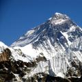
Peaked mountains tall, young in age, usually with narrow mountain gorges. These mountains include the Caucasus, Andes, Pamir, Himalayas with the highest peak in the world. Everest (Chomolungma) - 8 850 m (Fig. 48 , a ). Material from the site
Mountains with rounded peaks consist of soft rock formations, therefore they have smooth outlines, similar to waves. Mountain valleys are shallow, mostly with gentle slopes. In terms of height, these mountains are medium and low. For example, the Ukrainian Carpathians, the highest peak which is Hoverla (2,061 m), are medium-high (Fig. 48, b). There are mountains with flat peaks, steep or stepped slopes. In Ukraine, such mountains include the Crimean ones (Fig. 49).
In appearance, the mountains and plains are very different: the peaks of the Caucasus and the Andes are covered with snow and glaciers; smooth, like a table, tops Crimean mountains; flat West Siberian plain; hilly plains of Ukraine - how different they are! Small relief forms give them their uniqueness.
 |
| Rice. 49. Crimean mountains |
On this page material on topics:
Yandex plateau over 500m
World map of mountains and plains
Geography of the cr. gortus and plain
Okay google plain sushi synopsis
Classification of mountains and plains?
Questions about this material:
The earth's surface. On land, the plains occupy about 20% of the area, the most extensive of them are confined to and. All plains are characterized by small fluctuations in altitude and insignificant slopes (slopes reach 5 °). The following plains are distinguished according to the absolute height: lowlands - their absolute height is from 0 to 200 m (Amazonian);
- heights - from 200 to 500 m above sea level (Central Russian);
- upland, or plateaus - over 500 m above sea level ();
- the plains below sea level are called depressions (Caspian).
By the general nature of the surface of the plains are horizontal, convex, concave, flat, hilly.
According to the origin of the plains, the following types are distinguished:
- marine accumulative(cm. ). Such, for example, is the lowland with its sedimentary cover of young marine strata;
- continental accumulative... They were formed in the following way: at the foot of the mountains, the products of destruction carried out from them by streams of water are deposited. Such plains have a slight slope to sea level. These most often include the marginal lowlands;
- river accumulative... They are formed as a result of the deposition and accumulation of loose rocks brought in ();
- abrasion plains(see Abrasion). They have arisen as a result of the destruction of the coast by the activities of the sea. These plains appear the faster, the weaker the rocks and the more frequent the waves,;
- structural plains... They have a very complex origin. In the distant past they were mountainous countries... Over the course of millions of years, the mountains were destroyed by external forces, sometimes to the stage of almost plains (peneplains), then, as a result, cracks appeared, faults along which they poured onto the surface; it, like armor, covered the previous irregularities of the relief, its own surface remained flat or stepped as a result of the outpouring of traps. These are structural plains.
The surface of the plains, receiving sufficient moisture, is dissected by river valleys, dotted with complex systems of gullies and.
The study of the origin of the plains and the modern forms of their surface is very important. economic value, since the plains are densely populated and developed by man. There are many settlements, a dense network of communication lines, large and land. Therefore, it is with the plains that one has to deal with the development of new territories, the design of the construction of settlements, communication routes, industrial enterprises... As a result economic activity For humans, the relief of the plains can change significantly: ravines are filled up, embankments are built, open pit mining creates open pits, and near the mines, man-made hills of waste rock - waste rock heaps - grow.
Most of the ocean floor is occupied by depressions, the relief of which is flat. As on land, there are areas that are flat and hilly. The bottom of the oceanic plains is covered with sedimentary rocks up to several kilometers thick. One of the types of ocean plains is continental shoals. This is a part of the continent, lying below ocean level to a depth of 200 m. The continental shoals are covered with sedimentary, mainly detrital, rocks brought by rivers from land, as well as formed during the destruction of the coast by the surf
The largest plains on Earth