The concept of a natural complex
The main object of study of modern physical geography is the geographic envelope of our planet as a complex material system. It is heterogeneous both vertically and horizontally. In the horizontal, i.e. spatially, the geographic envelope is subdivided into separate natural complexes (synonyms: natural-territorial complexes, geosystems, geographic landscapes).
Natural complex is a territory homogeneous in origin, history of geological development and modern composition of specific natural components. It has a single geological foundation, the same type and amount of surface and groundwater, a uniform soil and vegetation cover and a single biocenosis (a combination of microorganisms and characteristic animals). In a natural complex, the interaction and exchange of substances between its constituent components are also of the same type. It is the interaction of the components that ultimately leads to the formation of specific natural complexes.
The level of interaction of components in a natural complex is determined primarily by the amount and rhythms of solar energy ( solar radiation). Knowing the quantitative expression of the energy potential of a natural complex and its rhythm, modern geographers can determine the annual productivity of its natural resources and the optimal timing of their renewability. This makes it possible to objectively predict the use of natural resources of natural-territorial complexes (NTC) in the interests of economic activity person.
At present, most of the natural complexes of the Earth have been changed to one degree or another by man, or even re-created by him on a natural basis. For example, desert oases, reservoirs, crop plantations. Such natural complexes are called anthropogenic. According to their purpose, anthropogenic complexes can be industrial, agricultural, urban, etc. According to the degree of change by human economic activity, in comparison with the initial natural state, they are divided into slightly altered, altered and strongly altered.
Natural complexes can be of different sizes - different ranks, as scientists say. The largest natural complex is the geographic shell of the Earth. Continents and oceans are natural complexes of the next rank. Within the continents, there are physical and geographical countries - natural complexes of the third level. Such, for example, as the East European Plain, Ural mountains, Amazonian lowlands, Sahara desert and others. Well-known natural zones can also serve as examples of natural complexes: tundra, taiga, temperate forests, steppes, deserts, etc. The smallest natural complexes (areas, natural boundaries, fauna) occupy limited areas. These are hilly ridges, individual hills, their slopes; or a low-lying river valley and its separate sections: channel, floodplain, above-floodplain terraces. It is interesting that the smaller the natural complex is, the more homogeneous its natural conditions. However, natural complexes of significant sizes retain the homogeneity of natural components and basic physical and geographical processes. So, the nature of Australia is not at all like nature. North America, The Amazonian lowland differs markedly from the adjacent Andes from the west, the Karakum desert (temperate zone) will not be confused by an experienced geographer-researcher with the Sahara (desert tropical belt) etc.
Thus, the entire geographic envelope of our planet consists of a complex mosaic of natural complexes of various ranks. Natural complexes formed on land are now called natural-territorial (NTC); formed in the ocean and another body of water (in a lake, river) - natural aquatic (PAK); natural-anthropogenic landscapes (PAL) are created by human economic activity on a natural basis.
The geographic envelope is the largest natural complex
The geographic shell is a continuous and integral shell of the Earth, including in a vertical section the upper part of the earth's crust (lithosphere), the lower atmosphere, the entire hydrosphere and the entire biosphere of our planet. What, at first glance, unites the heterogeneous components of the natural environment into a single material system? It is within geographic envelope there is a continuous exchange of matter and energy, a complex interaction between the specified component shells of the Earth.
The boundaries of the geographic envelope are still not clearly defined. For its upper border, scientists usually take the ozone screen in the atmosphere, beyond which life on our planet does not go. The lower boundary is most often drawn in the lithosphere at depths of no more than 1000 m. This is the upper part of the earth's crust, which is formed under the strong joint influence of the atmosphere, hydrosphere and living organisms. The entire water column of the World Ocean is inhabited, so if we talk about the lower boundary of the geographic shell in the ocean, then it should be drawn along the ocean floor. In general, the geographic shell of our planet has a total thickness of about 30 km.
As you can see, the geographic envelope in volume and territorially coincides with the distribution of living organisms on the Earth. However, there is still no common point of view regarding the relationship between the biosphere and the geographic envelope. Some scientists believe that the concepts of "geographic envelope" and "biosphere" are very close, even identical, and these terms are synonymous. Other researchers consider the biosphere only as a certain stage in the development of the geographic envelope. In this case, three stages are distinguished in the history of the development of the geographic envelope: prebiogenic, biogenic, and anthropogenic (modern). The biosphere, according to this point of view, corresponds to the biogenic stage in the development of our planet. In the opinion of others, the terms "geographic envelope" and "biosphere" are not identical, since they reflect different qualitative essence. In the concept of "biosphere", the main attention is focused on the active and decisive role of living matter in the development of the geographic envelope.
Which point of view to give preference to? It should be borne in mind that a number of specific features are characteristic of the geographic envelope. It is distinguished, first of all, by a wide variety of material composition and types of energy characteristic of all component shells - the lithosphere, atmosphere, hydrosphere and biosphere. Through general (global) cycles of matter and energy, they are united into an integral material system. To understand the patterns of development of this unified system is one of the most important tasks of modern geographical science.
Thus, the integrity of the geographic envelope is the most important regularity, on the knowledge of which the theory and practice of modern rational nature management is based. Taking into account this regularity makes it possible to predict possible changes in the nature of the Earth (a change in one of the components of the geographic envelope will necessarily cause a change in others); to give a geographical forecast of the possible results of human impact on nature; to carry out a geographical examination of various projects related to the economic use of certain territories.
Another characteristic regularity is inherent in the geographic envelope - the rhythm of development, i.e. recurrence in time of certain phenomena. In the nature of the Earth, rhythms of different duration have been identified - daily and annual, intrasecular and supersecular rhythms. The daily rhythm is known to be caused by the rotation of the Earth around its axis. The diurnal rhythm manifests itself in changes in temperature, air pressure and humidity, cloudiness, wind strength; in the phenomena of ebb and flow in the seas and oceans, the circulation of breezes, the processes of photosynthesis in plants, the daily biorhythms of animals and humans.
The annual rhythm is the result of the Earth's movement in its orbit around the Sun. This is the change of seasons, changes in the intensity of soil formation and destruction of rocks, seasonal features in the development of vegetation and human economic activity. It is interesting that different landscapes of the planet have different daily and annual rhythms. So, the annual rhythm is best expressed in temperate latitudes and very weakly - in the equatorial belt.
Of great practical interest is the study of longer rhythms: 11-12 years, 22-23 years, 80-90 years, 1850 years and longer, but, unfortunately, they are still less studied than the diurnal and annual rhythms.
Natural areas the globe, their brief description
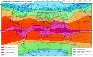
The great Russian scientist V.V. At the end of the last century, Dokuchaev substantiated the general planetary law of geographic zoning - a natural change in the components of nature and natural complexes when moving from the equator to the poles. Zoning is primarily due to the unequal (latitudinal) distribution of solar energy (radiation) over the Earth's surface, associated with the spherical shape of our planet, as well as different amounts of precipitation. Depending on the latitudinal ratio of heat and moisture, weathering and exogenous relief-forming processes are subject to the law of geographic zoning; zonal climate, surface waters of land and ocean, soil cover, vegetation and animal world.
The largest zonal subdivisions of the geographic envelope are geographic zones... They extend, as a rule, in the latitudinal direction and, in essence, coincide with climatic zones... Geographic zones differ from each other in temperature characteristics, as well as common features circulation of the atmosphere. The following geographic zones are distinguished on land:
Equatorial - common for the northern and southern hemispheres; - subequatorial, tropical, subtropical and temperate - in each hemisphere; - subantarctic and Antarctic belts - in southern hemisphere... Belts with similar names have been found in the World Ocean. Zonality in the ocean is reflected in the change from the equator to the poles of properties surface waters(temperature, salinity, transparency, wave intensity and others), as well as changes in the composition of flora and fauna.
Within the geographic zones, natural zones are distinguished according to the ratio of heat and moisture. The names of the zones are given according to the type of vegetation prevailing in them. For example, in subarctic belt these are tundra and forest-tundra zones; in the temperate - forest zones (taiga, mixed coniferous-broad-leaved and broad-leaved forests), forest-steppe and steppe zones, semi-deserts and deserts.
1. When brief description natural zones of the globe at the entrance exam, it is recommended to consider the main natural zones of the equatorial, subequatorial, tropical, subtropical, temperate, subarctic and arctic belts of the northern hemisphere in the direction from the equator to the North Pole: zone of evergreen forests (gili), savanna and woodlands zone, zone tropical deserts, zone of hard-leaved evergreen forests and shrubs (Mediterranean), zone of temperate deserts, zone of broad-leaved and coniferous-broad-leaved (mixed) forests, taiga zone, tundra zone, ice zone (zone of arctic deserts).
When characterizing natural areas, it is necessary to adhere to the following plan.
1. The name of the natural area.
2. Features of its geographical location.
3. The main features of the climate.
4. Prevailing soils.
5. Vegetation.
6. Animal world.
7. The nature of the use of natural resources of the zone by man.
The applicant can collect factual material for answering the indicated questions of the plan using thematic maps of the "Teacher's Atlas", which is required in the list of manuals and maps for the entrance exam in geography at KSU. This is not only not prohibited, but is also required by the "General Instructions" to the standard programs of entrance examinations in geography to universities in Russia.
However, the characterization of natural zones should not be "stereotyped". It should be borne in mind that due to the heterogeneity of the relief and earth surface, proximity and remoteness from the ocean (and, consequently, the heterogeneity of humidification), the natural zones of different regions of the continents do not always have a latitudinal strike. Sometimes they have an almost meridional direction, for example, on the Atlantic coast of North America, the Pacific coast of Eurasia, and other places. Natural zones are also heterogeneous, stretching latitudinally across the entire continent. They are usually subdivided into three segments corresponding to the central inland and two near-oceanic sectors. Latitudinal, or horizontal, zoning is best expressed on large plains, such as the East European or West Siberian plains.
V mountainous areas Of the earth latitudinal zoning the altitudinal zonation of landscapes gives way to a natural change of natural components and natural complexes with an ascent into the mountains from their foothills to the peaks. It is caused by climate change with altitude: С for every 100 m of rise and an increase in the number of degrees of temperature decrease by 0.6 precipitation to a certain height (up to 2-3 km). The change of belts in the mountains occurs in the same sequence as on the plains when moving from the equator to the poles. However, in the mountains there is a special belt of subalpine and alpine meadows, which is not found on the plains. The number of altitudinal zones depends on the height of the mountains and the characteristics of their geographic location. The higher the mountains and the closer they are to the equator, the richer their range (set) of altitudinal belts. The range of altitude zones in the mountains is also determined by the location mountain system relative to the ocean. In the mountains located near the ocean, a set of forest belts prevails; in the inland (arid) sectors of the continents, treeless altitudinal belts are characteristic.
Natural complex - a part of an ecosystem with established interrelationships between its various components, limited by natural natural boundaries: watersheds, the first regionally widespread stratum of poorly permeable rocks (aquiclude) and the surface layer of the atmosphere common to a given territory. Natural complexes confined to large waterways are subdivided into smaller ones related to tributaries of various orders. Accordingly, natural complexes of the first, second, third, etc. are distinguished. orders. In undisturbed conditions, two neighboring natural complexes can be almost completely identical, however, with the manifestation of technogenic impacts, any changes in the components of the ecosystem will affect primarily within the natural complex where the source of disturbance is located. In the conditions of urban agglomerations, natural complexes are the basic elements that form the natural component of the natural-man-made geosystem. The choice of the order of the natural complex, considered in each specific case, depends primarily on the scale of the work. In particular, for the city of Moscow, when carrying out small-scale works (1: 50,000 and smaller), it is advisable to single out natural complexes confined to the tributaries of the first order of the river. Moscow (Setun, Yauzy, Skhodnya, etc.) More detailed studies require consideration as "basic" natural complexes of smaller orders. For work performed on a scale of 1: 10000, it is optimal to consider natural complexes confined to tributaries of the second, third and (in some cases) fourth orders.
Territories of the natural complex - areas of the earth's surface, outlined by urban planning boundaries, within which green spaces have been preserved in relatively undisturbed conditions or partially restored. In Moscow, the territories of the natural complex include: urban and suburban forests and forest parks, parks, green areas for various purposes, water surfaces and river valleys.
It is necessary to distinguish between the concepts of "natural complex" and "territory of a natural complex": natural complex is a natural science concept, a single element of an ecosystem, while territory of a natural complex - an urban planning concept that determines the purpose and status of individual territories within the city of Moscow.
The doctrine of natural territorial complex, geographic landscape
Alexander Humboldt pointed out that “nature is a unity in a multitude, a combination of the diverse through form and mixing, there is the concept of natural things and natural forces as the concept of a living whole”.
A.N. Krasnov in 1895 formed the idea of "geographical combinations of phenomena" or "geographical complexes", which should be dealt with by private geography.
The generally recognized founders of Russian landscape science are V.V. Dokuchaev and L.S. Berg.
Landscape science began to develop especially rapidly in the 1960s in connection with the requests of practice, the development of agriculture and forestry, and land inventory. academicians S.V. Kalesnik, V.B. Sochava, I.P. Gerasimov, as well as physical geographers and landscape scientists N.A. Solntsev, A.G. Isachenko, D.L. Ardmand, and others.
In the works of K.G. Ramana, E.G. Kolomyitsa, V.N. Solntsev, the concept of polystructurality of landscape space was developed.
The most important areas of modern landscape science are anthropogenic, in which a person and the results of his economic activity are considered not only as an external factor that disturbs the landscape, but as an equal component of the NTC or natural-anthropogenic landscape.
On the theoretical basis of landscape science, new interdisciplinary directions are being formed that have significant integration significance for all geography (ecological geography, historical geography of landscapes, etc.)
Natural-territorial complex. TPK Group
Natural-territorial complex(natural geosystem, geographic complex, natural landscape), a natural spatial combination of natural components that form integral systems of different levels (from the geographic envelope to the facies); one of the basic concepts of physical geography.
Substances and energy are exchanged between individual natural territorial complexes and their components.
Groups of natural-territorial complexes :
1) global;
2) regional;
3) local.
Towards global PTK refers to the geographic envelope (some geographers include continents, oceans, and physical-geographical belts).
TO regional- physical and geographical countries, regions and other azonal formations, as well as zonal - physical and geographical zones, zones and subzones.
Local NTC, as a rule, are confined to meso- and microforms of the relief (ravines, gullies, river valleys, etc.) or to their elements (slopes, peaks, etc.).
Systematics of natural-territorial complexes
Option 1:
a) physical and geographical zoning.
b) physical and geographical country.
c) physical and geographical area.
d) physical and geographical area.
The result of work on physical and geographical zoning is a map of the USSR on a scale of 1: 8,000,000, and then a landscape map on a scale of 1: 4,000,000.
Under physical-geographical country is understood as a part of the continent formed on the basis of a large tectonic structure(plate, plate, platform, folded area) and the common tectonic regime in the Neogene-Quaternary time, characterized by a certain unity of relief (plains, plateau plates, heights of shields, mountains and highlands), microclimate and its structure of horizontal zoning and altitudinal zonality. Examples: Russian Plain, Ural Mountain country, Sahara, Fennoscandia. On the maps of physical and geographical zoning of continents, 65-75, sometimes more natural complexes are usually distinguished.
Physico-geographical area- a part of a physico-geographical country, isolated mainly during the Neogene-Quaternary time under the influence of tectonic movements, sea transgressions, continental glaciers, with the same type of relief, climate and a peculiar manifestation of horizontal zoning and altitudinal zoning. Examples: Meshcherskaya lowland, Central Russian Upland.
Option 2:
Typological classification... Determination of PTC by similarity.
a) Classes of natural complexes (mountainous and lowland).
b) Types (by zonal criterion)
c) Genera and species (by the nature of vegetation and some other characteristics).
Comparing the physical-geographical zoning and the typological classification of the PTC, it can be noted that in the system of physical-geographical zoning, the higher the rank of the PTC, the more unique it is, with the typological classification, on the contrary, the higher the rank, the less pronounced its individuality.
Waters, plants, animals, etc. All these components have gone a long way of development, so their combinations are not accidental, but natural. Due to their interaction, they are closely related to each other, and this interaction unites them into a single system, where all parts depend on one another and influence one another. Such a unified system is called a natural-territorial complex, or landscape. L.S. ... He defined natural-territorial complexes as areas similar in the prevailing nature of the relief, climate, waters, and soil cover. Natural complexes can be distinguished, etc. L.S. Berg wrote that a landscape (or a natural-territorial complex) is, as it were, an organism in which parts determine the whole, and the whole influences the parts.
The sizes of natural-territorial complexes are different. The largest can be considered the whole, the smallest -. The smallest natural-territorial complexes may include glades, ponds. It is important that, regardless of size, all components of these complexes are closely interconnected with each other.
Natural components are the reason for the formation of natural-territorial complexes. They are usually divided into two groups:
Zonal... These are external factors that depend on the uneven heating of the Earth by the Sun. (Uneven heating is explained by the sphericity of our Earth.) It changes depending on: when moving, the heating of the earth's surface decreases. Due to the factors, zonal natural-territorial complexes were formed: both natural (and the relief associated with it. Examples of azonal natural-territorial complexes ( natural areas) are, the Amazonian Plain, the Cordillera, the Himalayas, etc.
Thus, our Earth is a system of zonal and azonal complexes, and the azonal complexes together with the relief represent the base, and the zonal ones, like a veil, overlap them. Touching and penetrating each other, they form a landscape - part of a single geographic shell.
Natural-territorial complexes (landscapes) are characterized by a change in time. Most of all, they are influenced by human economic activity. Recently (within the framework of the development of the Earth), complexes created by man are beginning to appear on the planet - anthropogenic (Greek anthropos - man, genes - birth) landscapes. According to the degree of change, they are differentiated into:
- slightly altered - hunting grounds;
- changed - arable land, small settlements;
- highly modified - urban settlements, large mining, large-scale plowing, deforestation;
- improved - sanitary clearing of forests, park zone, "green zone" around large cities.
Human impact on landscapes is now an important nature-forming factor. Of course, human activity in our century cannot but change nature, but it must be remembered that the transformation of landscapes should take place taking into account the interconnection of all components of the natural-territorial complex. Only then can the disturbance of the natural balance be avoided.
The geographic envelope is not equally tripled everywhere; it has a "mosaic" structure and consists of separate natural complexes (landscapes). Natural complex - it is a part of the earth's surface with relatively uniform natural conditions: climate, relief, soils, waters, flora and fauna.
Each natural complex consists of components, between which there are close, historically established relationships, while a change in one of the components sooner or later leads to a change in others.
The largest, planetary natural complex is the geographic envelope, it is subdivided into natural complexes of a smaller rank. The division of the geographic envelope into natural complexes is due to two reasons: on the one hand, differences in the structure of the earth's crust and the heterogeneity of the earth's surface, and on the other hand, the unequal amount of solar heat received by its various areas. In accordance with this, zonal and azonal natural complexes are distinguished.
The largest azonal natural complexes are continents and oceans. Smaller - mountainous and flat areas within the continents ( West Siberian Plain, Caucasus, Andes, Amazonian lowland). The latter are subdivided into even smaller natural complexes (Northern, Central, Southern Andes). Natural complexes of the lowest rank include individual hills, river valleys, their slopes, etc.
The largest of the zonal natural complexes are geographic zones. They coincide with climatic zones and have the same names (equatorial, tropical, etc.). In turn, the geographic zones consist of natural zones, which are released by the ratio of heat and moisture.
Natural area is a large area of land with similar natural components - soils, vegetation, fauna, which are formed depending on the combination of heat and moisture.
The main component of the natural area is the climate, since all other components depend on it. Vegetation has a great influence on the formation of soils and wildlife and is itself dependent on soils. Natural zones are named according to the nature of vegetation, since it most obviously reflects other features of nature.
 The climate changes naturally as it moves from the equator to the poles. Soil, vegetation and fauna are determined by the climate. This means that these components must change latitudinal, following the climate change. The natural change in natural zones when moving from the equator to the poles is called latitudinal zoning. In the equator area there are wet equatorial forests, at the poles - ice arctic deserts... Between them are other types of forests, savannahs, deserts, tundra. Forest zones, as a rule, are located in areas where the ratio of heat and moisture is balanced (equatorial and most of the temperate zone, east coasts continents in tropical and subtropical zone). Treeless zones are formed where there is a lack of heat (tundra) or moisture (steppe, desert). These are continental regions of the tropical and temperate zones, as well as the subarctic climatic zone.
The climate changes not only latitudinal, but also due to changes in altitude. With the rise in the mountains, the temperature decreases. The amount of precipitation increases to an altitude of 2000-3000 m. A change in the ratio of heat and moisture causes a change in the soil - vegetation cover. Thus, different natural zones are located in the mountains at different heights. This pattern is called high-altitude zonation.
The change of altitude zones in the mountains occurs in approximately the same sequence as on the plains, when moving from the equator to the poles. At the foot of the mountains is located natural area in which they are located. The number of altitudinal zones is determined by the height of the mountains and their geographic location... The higher the mountains, and the closer they are to the equator, the more diverse the set of altitudinal zones. The vertical zonation is most fully expressed in the Northern Andes. In the foothills, humid equatorial forests grow, then there is a belt of mountain forests, and even higher - thickets of bamboos and tree ferns. With increasing altitude and decreasing average annual temperatures coniferous forests appear, which give way to mountain meadows, often turning, in turn, into stony placers covered with moss and lichens. The peaks of the mountains are crowned with snow and glaciers.
Still have questions? Want to know more about natural areas?
To get help from a tutor - register.
The first lesson is free!
www.site, with full or partial copying of the material, a link to the source is required.
NATURAL COMPLEX
NATURAL COMPLEX [from lat. complexus - connection, combination] - a set of natural objects, phenomena or properties that form one whole. PC. - the historical predecessor of the concept of a natural system. The term is used to denote: 1) any interconnected natural phenomena; 2) regular spatial combinations (mosaics) of soils, vegetation, landscapes (eg, salt marshes, etc.). PC. a broader concept than, for example, landscape or NTC, since it does not contain indications of either geography, territoriality, or the completeness of coverage of components.
Ecological Dictionary, 2001
Natural complex
(from lat. complexus - connection, combination) - a set of natural objects, phenomena or properties that form one whole. PC. - the historical predecessor of the concept of a natural system. The term is used to denote: 1) any interconnected natural phenomena; 2) regular spatial combinations (mosaics) of soils, vegetation, landscapes (eg, salt marshes, etc.). PC. a broader concept than, for example, landscape or NTC, since it does not contain indications of either geography, territoriality, or the completeness of coverage of components.
EdwART. Dictionary environmental terms and definitions, 2010
See what "NATURAL COMPLEX" is in other dictionaries:
A complex of functionally and naturally interconnected natural objects, united by geographic and other relevant features. EdwART. Glossary of terms of the Ministry of Emergency Situations, 2010 ... Emergency Dictionary
Natural complex- a complex of functionally and naturally related natural objects, united by geographic and other relevant features; ... Source: Federal Law of 10.01.2002 N 7 FZ (as amended on 25.06.2012) On protection environment … Official terminology
A complex of functionally and naturally related natural objects, united by geographic and other relevant features (Article 1 of the Law) Dictionary of business terms. Academic.ru. 2001 ... Business glossary- protected area near the city of Kyshtym Chelyabinsk region, 90 km north of Chelyabinsk, the Kyshtym Slyudorudnik highway runs between the lake and the mountain with a cave. The Kyshtym Tyubuk highway passes nearby. Consists of natural monuments Sugomakskaya ... ... Wikipedia
Geographic complex, geocomplex, geosystem, the term used to denote: 1) any interconnected natural phenomena; 2) regular spatial combinations (mosaics) of soils, vegetation, landscapes (for example, saline ... ... Ecological Dictionary
A historically formed and spatially isolated single indissoluble system formed by the main interacting and interdependent components of nature ( Earth's crust, atmosphere, water, plants, animals) developing under ... ... Ecological Dictionary
A natural combination of geographic components or complexes of the lowest rank, which are in complex interaction and form a single inextricable system of different levels from the geographic envelope to the facies. Between individual PTC and their ... ... Financial vocabulary
Page 1
A natural territorial complex is a historically formed and spatially isolated unity of the main components of the landscape. All the diversity of the surrounding nature is determined by the variety of combinations of natural components.
Natural territorial complexes and their components under the influence of human economic activity undergo reversible and irreversible changes. Many natural areas and natural objects change so much that they completely lose their resemblance to the original objects. For solving environmental problems, the landscape method is of particular importance, with the help of which it is possible to restore and reconstruct the original natural structure of the territory, to protect certain types, classes and types of NTC, their components from anthropogenic impact.
A natural territorial complex is a natural space, a combination of components of the natural environment, a part of natural resources (atmosphere, water, soil, vegetation, fauna, landscapes) that form an integral material system.
The stability of a natural territorial complex is its ability to withstand recreational loads up to a certain limit, beyond which there is a loss of its ability to heal itself.
The objects of the landscape-morphological analysis of the Earth are natural territorial complexes - historically formed and spatially isolated unity of the five main components of nature. The NTC form a hierarchical system of individual units that make it possible to carry out landscape-morphological analysis at various levels and carry out landscape mapping at various scales.
Natural and technogenic landscapes are understood as a combination of natural territorial complexes with technogenic modifications of natural complexes and technogenic neoplasms proper, which completely destroyed and altered natural landscapes during the production process.
The landscape envelope of the Earth is a mosaic structure of natural territorial complexes.
Analyzing OK should be guided by one general rule: natural territorial complexes with their structure and forest growth conditions are closely related to the height above sea level. Therefore, their boundaries often repeat the horizontal lines of the OK with a certain elevation. Locations of the same type located in different parts of the landscape also often coincide in height. Therefore, when identifying, mapping and typology of areas, it is necessary to constantly mark them. absolute heights above sea level.
Studying landscape units of various orders, he laid the foundation for landscape-morphological studies of the structure of natural territorial complexes. He showed that there is a hierarchical system of natural territorial units of varying size and complexity between the type of planting and the forest-growing zone.
When studying and mapping taiga territories, the main objects of research in solving a wide variety of practical problems should be natural territorial complexes - historically formed and spatially isolated unity of five main components of nature: lithogenic base, atmosphere, water, plants and animals, which N.A. Solntsev called complete natural unity. PTC differ in size and complexity, that is, in taxonomic rank. PTC within itself are relatively structurally and ecologically homogeneous formations, regardless of their rank.
CRITICAL LOAD (of a pollutant) is a quantitative expression of the maximum load (fallout) per unit area of a natural territorial complex of one or more pollutants, below which there is no harmful effect on the designated sensitive element of the environment (receptor) in accordance with the current level of knowledge.
The fundamental novelty of the method is that the object of interpretation is not the crown and structure of the forest canopy, but natural territorial complexes and their structure.
This course has been taught at the St. Petersburg Forestry Academy since 1996. It consists of 16 topics of lectures, gives an idea of the natural territorial complexes of forests in the boreal belt of the Earth. The influence of natural components on the structure and ecological regimes of forest lands, their forest growth effect is analyzed. The NTC of various types of plains, mountains, swamps are considered. Students are taught methods of landscape and environmental indicators using remote and cartographic information sources. The ways of applying the methods of morphological landscape science to solve practical problems of forestry, inventory of forest resources, forestry, land and nature management are shown.
Environmental justification - a set of arguments (evidence) and scientific forecasts, allowing to assess the environmental hazard of planned economic and other activities for ecosystems (natural territorial complexes) and humans.
Recently, the mathematical M.L. (A.S. Viktorov, 1998), which investigates the quantitative patterns of the construction of mosaics, which are formed on the earth's surface by natural territorial complexes that make up landscapes, and develops methods for the mathematical analysis of these mosaics.


