Geographical representations of the ancient Scandinavians
Great interest in Scandinavia in the geography of the world in the XII-XIV centuries. quite natural. The richest practical experience and knowledge on the topography of Europe was accumulated back in the Viking Age as a result of numerous campaigns of the Scandinavians to the west around Europe, to the islands of the North Atlantic up to the coast of North America and to the east, including Asia Minor, the Caspian countries, the Middle Volga region. This knowledge, not being fixed in writing until the 12th century, nevertheless was preserved in society and was reflected in the literature that existed at that time, primarily the sagas. The penetration of Western European scholarly works gave impetus to the creation of their own geographical literature, which was supposed to consolidate practical experience and generalize a variety of information about the lands known to the Scandinavians.
Scientific expeditions and theoretical discoveries of the XIX-XX centuries
It also describes the coordinate grid of the map, the lines of which have been drawn one step apart. Thus, from west to east, and also from Setentrion to Ahustro from north to south, according to modern usage, he could count the number of iguas and rely on the Ptolemy tradition, which is 4 degrees and 5 degrees parallel to Rhodes at 36 °.
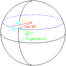
The goal is to indicate the ratio of the arc length to an equally large angle open in the north-south direction and at the same point in the east-west direction. The north-south meridian is the so-called great circle, and therefore the circumference of the equator on earth is considered a sphere, so that the angle open in the direction of the meridian has the same arc length at every point the earth's surface... In contrast, the expansion towards east and west latitude is a small circle, the circumference of which, as shown above, depends on the equatorial distance and therefore on the cosine of the central angle between the equatorial and latitudinal circles.
At the same time, Latin chorography has significantly expanded the range of geographical knowledge of the Scandinavians. By the XII century. it had already existed for six centuries and absorbed two very different traditions, the unification of which took place in the 6th-11th centuries. The most important complexes from which they drew information and which guided medieval geographers were the late Roman geographical writings (through which the Middle Ages became acquainted with ancient geography) and biblical cosmology and geography (72).
Thus, the arc length of an east-west angle is always less to the north or south of the equator than the meridian angle at the same point. Why does Ptolemy, who is referred to by Columbus, define this rule of calculation at 36 °? Well, he worked in Alexandria and the latitude goes through the Strait of Gibraltar and the island of Rhodes. For Mediterranean Sea it was a very practical and easy-to-use rule of thumb. However, according to his letter, Columbus applied this rule consistently, although Canary Islands are about 28 °, and the islands found in the Caribbean Sea are about 24 ° north latitude, for which not only very different, but also different cosines operate.
Ancient geography conveyed to the Middle Ages as its greatest achievements (ideas about the spherical shape of the Earth, about latitudinal zoning and others), as well as a set of information about the countries and peoples of the inhabited world, especially about those of them, the connection with which in the Middle Ages was lost (Central, Southeast Asia, Africa, except for the Mediterranean coast).
Therefore, the relatively simple rule of Ptolemy is no longer valid. If he now also knew that. On the flip side of the equation, the Italian mile would cover a circumference of 400 miles × 480 m = 192 km divided by an equatorial circumference of 800 km, i.e. a cosine value of 0, which is surprisingly accurate at 42 ° North latitude Columbus, according to de las Casas entry diary, notes : According to Father Mauro's Mapamundi, Chipango is also about 42 °, and Columbus is believed to be nearby.
Ptolemy Corrected New View of the Old World
Christopher Columbus was confident in his work. He wanted to discover a new sea route to Asia. That his mission was doomed to failure, he did not suspect, since his nautical charts made it too short distances. That's why he thought he was in Asia when he finally landed.
The immediate source of ancient geographical knowledge was the works of Julius Solin "A collection of things worthy of mention", written in end III or early IV century. n. NS. and containing extracts from the works of Mark Terentius Varro (116-27 BC), Pliny the Elder (23-79 AD), Pomponius Mela (I century AD), Macrobius "Comments to the sleep of Scipio "(the turn of the 4th-5th centuries), Marcianus, the Capella" On the marriage of Philology and Mercury "(5th century), finally, the most extensive encyclopedia of the Spanish bishop Isidore of Seville (c. 570-636) (73), which was the most important source of geographical knowledge of the Middle Ages.
According to the ancient explorer Ptolemy, surrounded by twelve winds there is land, cartographers in the Middle Ages. But the proportions were distorted. Like Columbus's world maps, all medieval atlases were more or less erroneous. The resulting cartographic material was the basis of all atlases up to late middle ages.
The atlases of the Ptolemies were perplexed not only by those travelers who missed their destination. The maps show various locations whose current location is unknown. Were some of the predecessors of today's cities some of the medieval centers? And what routes existed then? If interpreted, the cards can open up the world of antiquity.
The second foundational source of medieval geography was biblical cosmogony and cosmology and biblical geography. The formation of geographical representations was most influenced by the books Genesis and the Book of Job from the Old Testament literature, and the epistle of Paul from the New Testament literature. The interpretation of the first chapters of the book "Genesis", which tells about the creation of the Universe and the Earth, gave rise to an extensive literature, the beginning of which was laid by the Byzantine author of the 4th century. Basil of Caesarea (74). The role of the biblical tradition was especially great in the formation of the most general "theoretical" ideas about the world, which determined both the selection and interpretation of specific geographical facts.
They were able to assign their own position to each village. Among other things, the researchers passed on the secret of the legendary island of Thule. According to the Berlin Geodetic Survey, it is located opposite Trondheim. Claudius Ptolemy was one of the most famous scholars of the Roman Empire. He was of Greek origin and lived on the Egyptian Mediterranean coast. His astronomical and mathematical theories existed until the end of the Middle Ages. Ptolemy learned that the earth was a ball. He divided the planet into latitude and longitude; its definitions are still valid today.
However, with all the authoritarianism of the biblical picture of the world, attempts to create a geographic model of the Earth only on the basis of the Bible, without taking into account practical data, did not become widespread in Western Europe... Kosma Indikoplov's "Christian Topography" (beginning of the 6th century), an attempt to bring together and form a complete system of biblical cosmological and geographical concepts, drew criticism from contemporaries and did not find apologists in Western Europe (75). Therefore, the adaptation and coordination of ancient positive knowledge with the Christian concept of the universe, the formation of a more or less consistent picture of the Earth became the main task of Christian geographers early middle ages.
Data from Alexander the Great
In the second century, the Roman Empire reached its peak, stretching from the British Isles to Arabia. The empire had grown so much that no one knew what it looked like; there was no agreed map. Therefore, Ptolemy decided to investigate geographical coordinates all known world settlements. He relied on data from Greek scientists who lived centuries ago. For example, marshals under Alexander the Great measured the position of hundreds of settlements.
The Greeks Eratosthenes and Poseidonios also transmitted extensive geographic data. They were able to determine positions 10 km away based on the position of the sun. In the third century BC, Eratosthenes even calculated the circumference of the earth with amazing accuracy. Given the many data and accurate survey methods, it seemed incomprehensible why Ptolemy's descriptions were often wrong. He only gathered information from his predecessors.
This task was no longer faced by the Scandinavian geographers of the XII-XIV centuries. The ancient heritage has been revised and incorporated into the Christian geographic system much earlier and could not be perceived as something alien or foreign in her. The main task was to combine our own varied and extensive practical experience with geographic information and the general picture of the Earth in Christian geography (76). The result was the creation of a kind of fusion of the Christian (but in many moments dating back to antiquity) concept of the world, its division, landscape, peoples and specific, real information about Scandinavia itself and the surrounding lands. At the same time, the topography of the ecumene played an important role in both Christian and pagan belief systems. Therefore, the treatises published below reveal a complex interweaving of dissimilar elements (77).
If historical places can be restored, or knowledge of antiquity is lost, historians have asked themselves. In surveying, in collaboration with two historians of science, it is now possible to decipher data. Researchers came to the track by comparing the distances of famous settlements such as Istanbul and the list in Ptolemy with the actual distances.
In western Europe, distances have shrunk in the opposite direction. This error had its entry into medieval maps, which would also have made Columbus a beggar, he would not have accidentally discovered. The fall of the Roman Empire and the rise of Christianity as a religion indirectly influenced the stagnation of knowledge, both geographically and in other fields of knowledge. During the so-called "era of darkness" geographers viewed the Earth as a disk with Jerusalem and Earthly Paradise in the center. The ideas of the Greeks, contrary to the Christian concept, were rejected.
The spatial horizons of the Old Scandinavian geographical treatises basically cover the ecumene of the ancient world (78) in the form and degree as it was reflected in medieval chorography. The maximum expansion of the boundaries of known lands (before the era of the great geographical discoveries) refers to two periods: IV century. BC NS. - the time of the campaigns of Alexander the Great, when there was a direct acquaintance of Europeans with the countries of the East, Central Asia and there was real information about remote areas East Asia up to China, and the first centuries of our era - the heyday of the Roman Empire (79). This information continued to be preserved throughout the Middle Ages, but was not enriched personal experience and direct contacts with distant territories of Asia and Africa, they solidify and solidify as a stable and unchanging set of stamps.
Rogerio's book, in which Al-Idrimi collected a lot of information about known lands, different places, capitals and cities. His memoirs were recorded in the "Book of Miracles", which, although not properly geographic, aroused great interest in the knowledge of the regions of the Far East.
During the transition between the Middle Ages and modernity, known as the Renaissance, which traditionally coincides with the fall of Constantinople, the interest in travel and geographical discoveries rose again. This restoration of the adventurous spirit was facilitated, in particular, by the use of tools such as the compass, sextant and astrolabe. As a result, astronomical observations have been developed to improve navigation charts and more reliable coastal contour charts.
Based on the works of Orosius (early 5th century), Isidore of Seville (late 6th - first third of the 7th century), Beda the Venerable (late 7th - first third of the 8th century), Old Norse geographical treatises reproduce the entire complex of traditional Western European chorography. They are characterized by territory from India in the east to Spain and Ireland in the west, extending south to Ethiopia and the Sahara. The book origin of these descriptions is manifested both in the absence of any new data in comparison with their predecessors, and in the use of only established, dating back to ancient toponymy. The lack of personal knowledge about Asia and Africa also affects the constant inaccuracies in the transfer of names, errors in the location of countries, the assignment (sometimes in one work) of the same country to different parts of the world, etc.
The courage of the sailors allowed numerous voyages through which the knowledge of large spaces expanded, as each voyage provided more geographic information which contributed to the development of more accurate mapping. Among the most notable trips are those of Christopher Columbus. Others famous travelers were the Italian Juan Caboto, who, in the service of the English crown, crossed the dark Atlantic and reached the coast of North America in search of a route to travel to India.
Vasco da Gama opened a route to Calicut, India, and later, Francisco de Magallanes, was the first to trip around the world around the world. The expansion of the habitable boundary was quickly represented on maps. All the maps that existed at that moment on the planet appeared, and made some conclusions about the changes taking place in earth crust, thanks to the effects of tides and rivers, from direct observation of the Rhine and Danube.
However, the spatial horizons in Old Scandinavian geographical works are broader than in Western European chorography. It also includes those territories that were practically unknown to Western European geographers, but are well known to the Scandinavians: the Scandinavian countries and Finland, Eastern Europe, the islands Atlantic Ocean, North America... Knowledge about them accumulated gradually, starting from the 8th century, i.e., from the first campaigns of the Vikings, which was reflected in the oldest written sources of Scandinavia - runic monuments (80). Personal acquaintance with these regions is obvious both from the large number of details of a topographic, ethnographic, historical nature (81), and from the creation of their own toponymy for them.
Since the development of mapping was still unstable and there were no useful navigation tools, Gerhard Mercator found a mathematical solution that made it possible to represent a larger and better curved surface of the Earth on a plane. Mercator projected the earth's sphere onto a cylinder so that the meridians appeared as direct and distant parallels in the north-south direction. The Mercator projection, although it produces a certain deformation of the scale of the high latitudes of the north and south, made it possible, from that moment, the sailors could read constant compass readings on a straight line.
The idea of the shape, size and structure of the world is one of the most essential sections of geographical knowledge in any era. Created during the domination of Christian ideology, geographical writings could not but rely on the fundamental cosmological and geographical ideas for Christianity. In the Old Norse astronomical literature and computistics, based on practical observations, the Earth is often called jarрar bцllr - " Earth"(82). In geographical literature and sagas, the shape of the Earth is not specifically specified. In medieval geography, the concept of the spherical shape of the Earth, inherited from antiquity, was not forgotten or rejected (83). Although the most famous Christian authors in Scandinavia are Orosius, Isidore and some others bypassed the question of the shape of the Earth in silence, in other works, the manuscripts of which were also in the medieval libraries of Scandinavia (for example, "De sphaera" by Sacrobosco), the sphericity of the Earth was not only asserted, but also proved by experimental data. The same assumption could be put forward by the Scandinavians themselves on the basis of their own astronomical and navigational observations, for example, Odni-Stargazer (84).
The need to promote geographic knowledge and offer useful solutions has placed the teaching of geography at universities as a priority, where it has been integrated into the Department of Mathematics. An astrolabe is a tool used to independently determine the position of stars. Traditionally, there are two classes: spherical and flat. However, when talking about the astrolabe, the usual reference is to the flat astrolabe, already used by the ancient Greeks, who laid the foundation for its construction.
Astrolabe is an astronomical instrument that allows you to determine the position and height of stars above the sky. The images contain the traditional astrolabe and prisms. Until now, geographic thinking has acquired various nuances that have managed to enrich it until it becomes the science that we all know. But it is not always the case. Like everything else, its origins can be traced back to antiquity.
According to geographical treatises, the oikumene is surrounded by the "world sea" (ъmsjуr "or, according to the book, the Ocean"). The idea of an ocean-river washing the inhabited world is characteristic of all ancient literature, began with Homer, and passes into the Middle Ages (85); at the same time in the Old Norse pagan cosmology the idea of the "outer sea" is also presented.
From Homer's verses we already find geographical descriptions that combine cosmology and astronomy with his works. In this line, Anaximander and Herodotus continue, who are considered the first geographical ones, in addition to having the honor of being the father of History. This will be Ptolemy, which includes the first map, and the Roman scholars will be based on this. Strabo, was the first to confirm that the Earth was a spherical star and was based on this hypothesis, which he described. Pliny, the Elder, and Julius Caesar include among their works the studies of the Greeks that preceded them.
Inhabited world(heimr) is divided into three parts: Asia, Africa and Europe, the first of which occupies the eastern half (much less often - a third) of the world, the second - the south of the western half, the third - the north of the western half. Parts of the world are separated by the Mediterranean Sea, which is considered the gulf of the World Ocean, and the Tanais (Don) and Geon (Nile) rivers. Obviously, the views on the division of the Earth and the boundaries of the parts in Old Norse geography are not original, but borrowed from Western European authors, who, in turn, fully rely on the ancient tradition, coming from Hecateus (86).
When the Middle Ages came, geography was adapted to suit the interests of scholars. For example, in the Christian world Jerusalem will become the center of the world and in the Islamic world, Mecca will take the same place. The most significant of the Christian scholars were works based on the description and compilation work of the classical texts, especially Ptolemy.
The modern age has been a moment of change and a boom for geography, as the commercial interests of the time were directly related to geographic knowledge. Mercator was the first to make a cylindrical projection based on meridians and parallels, and Cassini headed the French school.
In the extreme east, in accordance with biblical geography, paradise is located, detailed description which was borrowed from Isidore (Etym., XIV, HI, 2-3) (87). Thus, the ideas about the origin and organization of physical and geographical space are fully consistent with the Christian concept of the world, developed in the works of the largest theologians of the 3rd-5th centuries. ad.
The problems of ethnogenesis in geographical treatises are essentially consistent with the biblical ethnogenetic legend: after the Flood, the world was inhabited by the descendants of Noah: Shem (Asia), Ham (Africa) and Japheth (Europe); from them come all the peoples of the world. However, the list of peoples given in the Bible (Genesis, IX, 18 - XI, 32) (88) and conditioned by the spatial outlook of its creators did not correspond at all either to the historical situation of the XII-XIV centuries, or to the outlook of the Old Norse geographers. A significant number of the peoples of Europe, and first of all the Scandinavians themselves, were not involved in a single family of Christian peoples. Therefore, the lists of peoples descended from Shem, Ham and Japheth, already somewhat replenished by Jerome and Isidor, are being further expanded and modernized in Scandinavia. Leaving practically untouched the lists of the peoples of Asia and Africa, the compilers of both general descriptions of the Earth and a special treatise "On the settlement of the earth by the sons of Noah" include in the list of the peoples of Europe, first of all, the inhabitants of Scandinavia, the Eastern Baltic, Ancient Russia, based on the information at their disposal about ethnic composition these regions.
Among the general problems of physical geography considered by ancient geographers (climate, origin of physical and geographical phenomena, soil, etc.), the Middle Ages continued to develop the theory of latitudinal zoning (89). Following the Western European tradition, Old Norse geographers distinguish three climatic zones: hot, moderate and cold, of which only moderate is considered fit for life.
Based on their own observations, they clarify the northern boundaries of the inhabited zone, move them much further north: the extreme in the north populated area they consider Bjarmaland and Greenland, connected with it (according to the then ideas). European geographers unfamiliar with Scandinavia, in their descriptions usually reach South Sweden and Norway, sometimes they mention Iceland, but the northern part of Fennoscandia and of Eastern Europe they are practically unknown.
Spatial orientation as a problem is more philosophical than geographical, but the principles of orientation of the physical space surrounding a person play a very important role in characterizing the geographical views of the ancient Scandinavians. It was noticed long ago that the direction of movement indicated in the sagas (and the cardinal points in geographical treatises) can either correspond to the real one or deviate from it, and it was not possible to identify any system in these deviations. However, a study of generic sagas (90) showed that there were two orientation systems: one related to the description of voyages in the open sea and based on sufficiently accurate observations of the starry sky, the second - to characterize movement on land (in this study, inside Iceland) and at coastal voyages based on administrative division Iceland by a quarter. In the first system, the real directions and those denoted by the terms norрr, suрr, vestr, austr (north, south, west, east) coincide. In the second center of orientation is administrative center each of the quarters, and the direction of movement is determined relative to it, and not to the cardinal points, that is, when moving from the Western quarter to North direction designated as north, although the real was northeast or east.
Apparently, similar principles of space orientation are reflected in geographical treatises, where, as a rule, the center of orientation is the southern part of the Scandinavian Peninsula and the direction is determined by the initial phase of movement: that is, all lands, no matter how they are actually located in relation to Scandinavia, are considered to be lying to the east, if the path to them goes through the Eastern Baltic and Russia (for example, Byzantium, Palestine), or located in the north, if the path runs through the northern part of the Scandinavian Peninsula. Thus, the system of spatial orientation in geographical treatises is highly arbitrary and does not always correspond to the real one.
Geographical Middle Ages Traveler Discovery
Federal State Budgetary educational institution higher professional education
Russian State Pedagogical University. A. I. Herzen
Department of Physical Geography and Environmental Management
Abstract on the topic:
Geography in the Middle Ages
Geographical representations of the early Middle Ages
Geography in antiquity reached high level development. Ancient geographers adhered to the doctrine of the sphericity of the earth and had a fairly correct idea of its size. In their writings, the doctrine of the climate and the five climatic zones the globe, the question of the predominance of land or sea (the dispute between oceanic and land theories) was sharply debated. The pinnacle of ancient achievements was the cosmogonic and geographical theory of Ptolemy (II century AD), despite its shortcomings and inaccuracies, and unsurpassed until the 16th century.
The Middle Ages wiped out ancient knowledge from the face of the earth. The domination of the church in all areas of culture also meant a complete decline in geographical concepts: geography and cosmogony were completely subordinated to church needs. Even Ptolemy, left as the supreme authority in this area, was emasculated and adapted to the needs of religion. The Bible became the supreme authority in the field of cosmogony and geography - all geographical representations were based on its data and aimed at explaining them.
Widespread "theories" about the land floating in the ocean on whales or turtles, about the precisely outlined "end of the earth", about the heavenly firmament supported by pillars, etc. Geography was subject to biblical canons: Jerusalem was located in the center of the earth, in the east, beyond the lands of Gog and Magog, there was paradise, from which Adam and Eve were expelled, all these lands were washed by the ocean that arose as a result of the worldwide flood.
One of the most popular at that time was the "geographical theory" of the Alexandrian merchant, and then the monk Kozma Indikoplov (Indikopleista, that is, who sailed to India), who lived in the first half of the 6th century. He "proved" that the earth has the shape of the "Tabernacle of Moses", that is, the tent of the biblical prophet Moses, - a rectangle with a length to width ratio of 2: 1 and a semicircular vault. The ocean with four bays-seas (Roman, i.e. Mediterranean, Red, Persian and Caspian) separates the inhabited land from eastern land, where paradise is located and from where the Nile, Ganges, Tigris and Euphrates originate. In the northern part of the land there is a high mountain around which the celestial spheres revolve, in summer, when the sun is high, it does not hide behind the top for long, and therefore summer nights are short compared to winter, when it goes beyond the foot of the mountain.
Such views, naturally, were supported by the church as "true", corresponding to the spirit of Holy Scripture. It is not surprising that as a result of this, absolutely fantastic information was spread in Western European society about various regions and peoples inhabiting them - people with dog heads and generally headless people, having four eyes, living with the smell of apples, etc. Perverted legend, or even just fiction , which does not have any ground, became the basis of the geographical representations of that era.
One of these legends, however, played a significant role in the political and social life of the early and advanced Middle Ages; this is a legend about the Christian state of the priest John, allegedly located somewhere in the east. Now it is already difficult to determine what is at the heart of this legend - whether vague ideas about the Christians of Ethiopia, Transcaucasia, the Nestorians of China, or a simple invention, caused by the hope of outside help in the fight against a formidable enemy. In search of this state, a natural ally of the European Christian countries in their struggle against the Arabs and Turks, various embassies and travels were undertaken.
Against the background of the primitive views of the Christian West, the geographical representations of the Arabs stand out sharply. Arab travelers and seafarers already in the early Middle Ages collected a huge baggage of data about many, including distant, countries. “The outlook of the Arabs,” according to the Soviet Arabist I. Yu. Krachkovsky, “embraced virtually all of Europe with the exception of the Far North, the southern half of Asia, North Africa... and the shores of East Africa ... The Arabs gave Full description all countries from Spain to Turkestan and the mouth of the Indus with a detailed listing settlements, with a characteristic of cultural spaces and deserts, with an indication of the area of distribution of cultivated plants, locations of minerals ”.
The Arabs also played a large role in the preservation of the ancient geographical heritage, already in the 9th century. translating the geographical works of Ptolemy into Arabic. True, having accumulated a huge wealth of information about the world around them, the Arabs did not create major generalizing works that would theoretically comprehend all this baggage; their general concepts of the structure of the earth's surface did not surpass Ptolemy. However, it was thanks to this that Arab geographical science had a great influence on the science of the Christian West.
Travels in the early Middle Ages were casual, episodic. They were not faced with geographic tasks: the expansion of geographic concepts was only an incidental consequence of the main goals of these expeditions. And they were most often religious motives (pilgrimages and missions), trade or diplomatic goals, sometimes military conquests (often robbery). Naturally, the geographical information obtained in this way was fantastic and inaccurate, which did not last long in the memory of people.
However, before proceeding to the story of the geographical discoveries of the early Middle Ages, it is necessary to understand the very concept of geographical discovery. The essence of this concept causes great disagreement among historians of geography. Some of them propose to consider the first historically proven visit by the representatives of the peoples who know the letter to the lands unknown to them as a geographical discovery; others are the first description or mapping of these lands; still others share the discovery of populated land and uninhabited objects, etc.
Various "levels" of territorial discoveries are also considered. On the first of them, local, the opening of this territory by the people inhabiting it takes place. This information remains, as a rule, the property of one people and often disappears along with it. The next level is regional: information about various areas, regions, often far from the places of settlements of peoples-researchers; they are often sporadic and have little impact on the geographical representations of subsequent eras. And, finally, discoveries of the world, global level, which become the property of all mankind.
The discoveries of Western European travelers of the early Middle Ages, as a rule, belong to the regional level. Many of them were forgotten or did not even become widely known to the then world; world science learned about them only in the XIX-XX centuries; the memory of others has survived through the centuries, but mainly in the form of legends and fantastic stories, so far from their basis that it is now impossible to establish their true essence. But this does not diminish the importance of sometimes insane in their boldness undertakings, which arouse in us both a sense of admiration and distrust. These feelings are further enhanced by the thought that only a small part of travel is reflected in written records.
The most common in the early Middle Ages were travel with "pious" purposes - pilgrimage and missionary work. As for the pilgrimages, most of them were limited to Rome, only individuals dared to go to Jerusalem. Missionary work, especially the Irish, was much more widespread. Irish hermit monks in the 6th-8th centuries opened the way to the Hebrides, Shetland, Farrers and even Iceland and partially settled them (however, this colonization, in particular of Iceland, was short-lived). Sometimes missionaries embarked on journeys of exceptional courage: these include the alleged journey of the Nestorian Syrian missionary Olopena (7th century) to China and the more reliable journey of the English bishop Siegelm (9th century) to South India.
The embassies of that era had an immeasurably greater resonance in society. The most important of them are: the Estonian embassy to the court of Theodorich of Ostrogothic (6th century), two embassies of Charlemagne to Harun al-Rashid (9th century), Arab diplomatic missions to Eastern Europe (Scandinavia, Volga Bulgaria, etc.) and other diplomatic undertakings sometimes lack a definite purpose (for example, in the "state of the priest John"). The actual diplomatic value of all these embassies was small, but they played a large role in arousing the interest of Western European society in new countries.
From what has been said, it is clear that the scope of travel in the early Middle Ages was small: over the course of half a millennium, only a few of them ended in serious discoveries. And the point here is not only that we know some of these enterprises; those who remained unknown were hardly widely known to their contemporaries. The reason for the small scale of travel is that trade, the main incentive for this type of activity, was of an accidental nature.
ANCIENT SCANDINAVIAN GEOGRAPHIC WORKS
Geographical representations of the ancient Scandinavians
Great interest in Scandinavia in the geography of the world in the XII-XIV centuries. quite natural. The richest practical experience and knowledge on the topography of Europe was accumulated back in the Viking Age as a result of numerous campaigns of the Scandinavians to the west around Europe, to the islands of the North Atlantic up to the coast of North America and to the east, including Asia Minor, the Caspian countries, the Middle Volga region. This knowledge, not being fixed in writing until the 12th century, nevertheless was preserved in society and was reflected in the literature that existed at that time, primarily the sagas. The penetration of Western European scholarly works gave impetus to the creation of their own geographical literature, which was supposed to consolidate practical experience and generalize various information about the lands known to the Scandinavians.
At the same time, Latin chorography has significantly expanded the range of geographical knowledge of the Scandinavians. By the XII century. it had already existed for six centuries and absorbed two very different traditions, the unification of which took place in the 6th-11th centuries. The most important complexes from which they drew information and which guided medieval geographers were the late Roman geographical writings (through which the Middle Ages became acquainted with ancient geography) and biblical cosmology and geography (72).
Thus, the arc length of an east-west angle is always less to the north or south of the equator than the meridian angle at the same point. Why does Ptolemy, who is referred to by Columbus, define this rule of calculation at 36 °? Well, he worked in Alexandria and the latitude goes through the Strait of Gibraltar and the island of Rhodes. For the Mediterranean, this was a very practical and easy-to-use rule of thumb. However, according to his letter, Columbus consistently applied this rule, although the Canary Islands are about 28 °, and the islands discovered in the Caribbean Sea are about 24 ° north latitude, for which not only very different, but also different cosines operate.
Ancient geography conveyed to the Middle Ages both its greatest achievements (ideas about the spherical shape of the Earth, latitudinal zoning, etc.), and a set of information about the countries and peoples of the inhabited world, especially about those of them, the connection with which in the Middle Ages was lost (Middle , Southeast Asia, Africa, except for the Mediterranean coast).
Therefore, the relatively simple rule of Ptolemy is no longer valid. If he now also knew that. On the flip side of the equation, the Italian mile would cover a circumference of 400 miles × 480 m = 192 km divided by an equatorial circumference of 800 km, i.e. a cosine value of 0, which is surprisingly accurate at 42 ° North latitude Columbus, according to de las Casas entry diary, notes : According to Father Mauro's Mapamundi, Chipango is also about 42 °, and Columbus is believed to be nearby.
Ptolemy Corrected New View of the Old World
Christopher Columbus was confident in his work. He wanted to discover a new sea route to Asia. That his mission was doomed to failure, he did not suspect, since his nautical charts made him too short distances. That's why he thought he was in Asia when he finally landed.
The immediate source of ancient geographical knowledge was the works of Julius Solin "A collection of things worthy of mention", written at the end of the 3rd or the beginning of the 4th century. n. NS. and containing extracts from the works of Mark Terentius Varro (116-27 BC), Pliny the Elder (23-79 AD), Pomponius Mela (I century AD), Macrobius "Comments to the sleep of Scipio "(the turn of the 4th-5th centuries), Marcianus, the Capella" On the marriage of Philology and Mercury "(5th century), finally, the most extensive encyclopedia of the Spanish bishop Isidore of Seville (c. 570-636) (73), which was the most important source of geographical knowledge of the Middle Ages.
According to the ancient explorer Ptolemy, surrounded by twelve winds there is land, cartographers in the Middle Ages. But the proportions were distorted. Like Columbus's world maps, all medieval atlases were more or less erroneous. The resulting cartographic material was the basis of all atlases up to the late Middle Ages.
The atlases of the Ptolemies were perplexed not only by those travelers who missed their destination. The maps show various locations whose current location is unknown. Were some of the predecessors of today's cities some of the medieval centers? And what routes existed then? If interpreted, the cards can open up the world of antiquity.
The second foundational source of medieval geography was biblical cosmogony and cosmology and biblical geography. The formation of geographical representations was most influenced by the books Genesis and the Book of Job from the Old Testament literature, and the epistle of Paul from the New Testament literature. The interpretation of the first chapters of the book "Genesis", which tells about the creation of the Universe and the Earth, gave rise to an extensive literature, the beginning of which was laid by the Byzantine author of the 4th century. Basil of Caesarea (74). The role of the biblical tradition was especially great in the formation of the most general "theoretical" ideas about the world, which determined both the selection and interpretation of specific geographical facts.
They were able to assign their own position to each village. Among other things, the researchers passed on the secret of the legendary island of Thule. According to the Berlin Geodetic Survey, it is located opposite Trondheim. Claudius Ptolemy was one of the most famous scholars of the Roman Empire. He was of Greek origin and lived on the Egyptian Mediterranean coast. His astronomical and mathematical theories existed until the end of the Middle Ages. Ptolemy learned that the earth was a ball. He divided the planet into latitude and longitude; its definitions are still valid today.
However, for all the authoritarianism of the biblical picture of the world, attempts to create a geographic model of the Earth only on the basis of the Bible, without taking into account practical data, did not become widespread in Western Europe. Kosma Indikoplov's "Christian Topography" (beginning of the 6th century), an attempt to bring together and form a complete system of biblical cosmological and geographical concepts, drew criticism from contemporaries and did not find apologists in Western Europe (75). Therefore, the adaptation and coordination of ancient positive knowledge with the Christian concept of the universe, the formation of a more or less consistent picture of the Earth became the main task of Christian geographers of the early Middle Ages.
Data from Alexander the Great
In the second century, the Roman Empire reached its peak, stretching from the British Isles to Arabia. The empire had grown so much that no one knew what it looked like; there was no agreed map. Therefore, Ptolemy decided to investigate the geographical coordinates of all known world settlements. He relied on data from Greek scientists who lived centuries ago. For example, marshals under Alexander the Great measured the position of hundreds of settlements.
The Greeks Eratosthenes and Poseidonios also transmitted extensive geographic data. They were able to determine positions 10 km away based on the position of the sun. In the third century BC, Eratosthenes even calculated the circumference of the earth with amazing accuracy. Given the many data and accurate survey methods, it seemed incomprehensible why Ptolemy's descriptions were often wrong. He only gathered information from his predecessors.
This task was no longer faced by the Scandinavian geographers of the XII-XIV centuries. The ancient heritage was revised and incorporated into the Christian geographical system much earlier and could not be perceived as something alien or alien in it. The main task was to combine our own diverse and extensive practical experience with geographical information and the general picture of the Earth in Christian geography (76). The result was the creation of a kind of fusion of the Christian (but in many moments dating back to antiquity) concept of the world, its division, landscape, peoples and specific, real information about Scandinavia itself and the surrounding lands. At the same time, the topography of the ecumene played an important role in both Christian and pagan belief systems. Therefore, the treatises published below reveal a complex interweaving of dissimilar elements (77).
If historical sites can be restored, or knowledge of antiquity is lost, historians have asked themselves. In surveying, in collaboration with two historians of science, it is now possible to decipher data. Researchers came to the track by comparing the distances of famous settlements such as Istanbul and the list in Ptolemy with the actual distances.
In western Europe, distances have shrunk in the opposite direction. This error had its entry into medieval maps, which would also have made Columbus a beggar, he would not have accidentally discovered. The fall of the Roman Empire and the rise of Christianity as a religion indirectly influenced the stagnation of knowledge, both geographically and in other fields of knowledge. During the so-called "era of darkness" geographers viewed the Earth as a disk with Jerusalem and Earthly Paradise in the center. The ideas of the Greeks, contrary to the Christian concept, were rejected.
The spatial horizons of the Old Scandinavian geographical treatises basically cover the ecumene of the ancient world (78) in the form and degree as it was reflected in medieval chorography. The maximum expansion of the boundaries of known lands (before the era of the great geographical discoveries) refers to two periods: IV century. BC NS. - the time of the campaigns of Alexander the Great, when there was a direct acquaintance of Europeans with the countries of the East, Central Asia and real information appeared about the remote regions of East Asia up to China, and the first centuries of our era - the heyday of the Roman Empire (79). This information continued to persist throughout the Middle Ages, but, not enriched by personal experience and direct contacts with remote territories of Asia and Africa, they solidify and solidify as a stable and unchanging set of cliches.
Rogerio's book, in which Al-Idrimi collected a lot of information about famous lands, different places, capitals and cities. His memoirs were recorded in the "Book of Miracles", which, although not properly geographic, aroused great interest in the knowledge of the regions of the Far East.
During the transition between the Middle Ages and modernity, known as the Renaissance, which traditionally coincides with the fall of Constantinople, interest in travel and geographical discovery has revived. This restoration of the adventurous spirit was facilitated, in particular, by the use of tools such as the compass, sextant and astrolabe. As a result, astronomical observations have been developed to improve navigation charts and more reliable coastal contour charts.
Based on the works of Orosius (early 5th century), Isidore of Seville (late 6th - first third of the 7th century), Beda the Venerable (late 7th - first third of the 8th century), Old Norse geographical treatises reproduce the entire complex of traditional Western European chorography. They are characterized by territory from India in the east to Spain and Ireland in the west, extending south to Ethiopia and the Sahara. The book origin of these descriptions is manifested both in the absence of any new data in comparison with their predecessors, and in the use of only established, dating back to ancient toponymy. The lack of personal knowledge about Asia and Africa also affects the constant inaccuracies in the transfer of names, errors in the location of countries, the assignment (sometimes in one work) of the same country to different parts of the world, etc.
The courage of the sailors allowed numerous voyages through which knowledge of large areas expanded, as each voyage provided more geographic information that contributed to the development of more accurate mapping. Among the most notable trips are those of Christopher Columbus. Other famous travelers were the Italian Juan Caboto, who in the service of the English crown crossed the dark Atlantic and reached the coast of North America in search of a route to travel to India.
Vasco da Gama opened a route to Calicut, India, and later, Francisco de Magallanes, was the first to travel around the world. The expansion of the habitable boundary was quickly represented on maps. All the maps that existed at that moment on the planet appeared, and made some conclusions about the changes taking place in the earth's crust, thanks to the effects of tides and rivers, from direct observation of the Rhine and Danube.
However, the spatial horizons in Old Scandinavian geographical works are broader than in Western European chorography. It also includes those territories that were practically unknown to Western European geographers, but well known to the Scandinavians: the Scandinavian countries and Finland, Eastern Europe, the islands of the Atlantic Ocean, North America. Knowledge about them accumulated gradually, starting from the 8th century, i.e., from the first campaigns of the Vikings, which was reflected in the oldest written sources of Scandinavia - runic monuments (80). Personal acquaintance with these regions is obvious both from the large number of details of a topographic, ethnographic, historical nature (81), and from the creation of their own toponymy for them.
Since the development of mapping was still unstable and there were no useful navigation tools, Gerhard Mercator found a mathematical solution that made it possible to represent a larger and better curved surface of the Earth on a plane. Mercator projected the earth's sphere onto a cylinder so that the meridians appeared as direct and distant parallels in the north-south direction. The Mercator projection, although it produces a certain deformation of the scale of the high latitudes of the north and south, made it possible, from that moment, the sailors could read constant compass readings on a straight line.
The idea of the shape, size and structure of the world is one of the most essential sections of geographical knowledge in any era. Created during the domination of Christian ideology, geographical writings could not but rely on the fundamental cosmological and geographical ideas for Christianity. In the Old Norse astronomical literature and computistics, based on practical observations, the Earth is often called jar đar böllr - " the globe "(82). In the geographical literature and sagas, the shape of the Earth is not specifically specified. In medieval geography, the concept of the spherical shape of the Earth, inherited from antiquity, was not forgotten or rejected. (83) Although the most famous Christian authors in Scandinavia are Orosius, Isidore and some others bypassed the question of the shape of the Earth in silence, in other works, the manuscripts of which were also in the medieval libraries of Scandinavia (for example, "De sphaera" by Sacrobosco), the sphericity of the Earth was not only asserted, but also proved by experimental data. the scribes could not but be familiar, and the same assumption could have been put forward by the Scandinavians themselves on the basis of their own astronomical and navigational observations, for example, Odni-Stargazer (84). According to geographical treatises, the ecumene is surrounded by the "world sea" ( úmsjór " or, according to the book, the Ocean "). The concept of an ocean-river washing the inhabited world is characteristic of all ancient literature, began with Homer, and passes into the Middle Ages (85); at the same time, the idea of an" outer sea ". The inhabited world (heimr) is divided into three parts: Asia, Africa and Europe, the first of which occupies the eastern half (much less often - a third) of the world, the second - the south of the western half, the third - the north of the western half. Parts of the world are separated by the Mediterranean Sea, which is considered the gulf of the World Ocean, and the Tanais (Don) and Geon (Nile) rivers. Obviously, the views on the division of the Earth and the boundaries of the parts in Old Norse geography are not original, but borrowed from Western European authors, who, in turn, fully rely on the ancient tradition, coming from Hecateus (86). When the Middle Ages came, geography was adapted to suit the interests of scholars. For example, in the Christian world Jerusalem will become the center of the world and in the Islamic world, Mecca will take the same place. The most significant of the Christian scholars were works based on the description and compilation work of the classical texts, especially Ptolemy. The modern age has been a moment of change and a boom for geography, as the commercial interests of the time were directly related to geographic knowledge. Mercator was the first to make a cylindrical projection based on meridians and parallels, and Cassini headed the French school. In the extreme east, in accordance with biblical geography, there is a paradise, a detailed description of which was borrowed from Isidore (Etym., XIV, HI, 2-3) (87). Thus, the ideas about the origin and organization of physical and geographical space are fully consistent with the Christian concept of the world, developed in the works of the largest theologians of the 3rd-5th centuries. ad. The problems of ethnogenesis in geographical treatises are essentially consistent with the biblical ethnogenetic legend: after the Flood, the world was inhabited by the descendants of Noah: Shem (Asia), Ham (Africa) and Japheth (Europe); from them come all the peoples of the world. However, the list of peoples given in the Bible (Genesis, IX, 18 - XI, 32) (88) and conditioned by the spatial outlook of its creators did not correspond at all either to the historical situation of the XII-XIV centuries, or to the outlook of the Old Norse geographers. A significant number of the peoples of Europe, and first of all the Scandinavians themselves, were not involved in a single family of Christian peoples. Therefore, the lists of peoples descended from Shem, Ham and Japheth, already somewhat replenished by Jerome and Isidor, are being further expanded and modernized in Scandinavia. Leaving practically untouched the lists of the peoples of Asia and Africa, the compilers of both general descriptions of the Earth and a special treatise "On the settlement of the earth by the sons of Noah" include in the list of the peoples of Europe, first of all, the inhabitants of Scandinavia, the Eastern Baltic, Ancient Russia, based on the information at their disposal about the ethnic composition of these regions. Among the general problems of physical geography considered by ancient geographers (climate, origin of physical and geographical phenomena, soil, etc.), the Middle Ages continued to develop the theory of latitudinal zoning (89). Following the Western European tradition, Old Scandinavian geographers distinguish three climatic zones: hot, temperate and cold, of which only moderate is considered suitable for life. Spatial orientation as a problem is more philosophical than geographical, but the principles of orientation of the physical space surrounding a person play a very important role in characterizing the geographical views of the ancient Scandinavians. It was noticed long ago that the direction of movement indicated in the sagas (and the cardinal points in geographical treatises) can either correspond to the real one or deviate from it, and it was not possible to identify any system in these deviations. However, a study of generic sagas (90) showed that there were two orientation systems: one related to the description of voyages in the open sea and based on sufficiently accurate observations of the starry sky, the second - to characterize movement on land (in this study, inside Iceland) and at coastal voyages based on the administrative division of Iceland into quarters. In the first system, the directions are real and denoted by the terms nor đr, suđr, vestr, austr ( north, south, west, east) match. In the second, the center of orientation is the administrative center of each of the quarters, and the direction of movement is determined relative to it, and not the cardinal points, that is, when moving from the Western Quarter to the North, the direction was designated as north, although the real was northeast or east. Apparently, similar principles of space orientation are reflected in geographical treatises, where, as a rule, the center of orientation is the southern part of the Scandinavian Peninsula and the direction is determined by the initial phase of movement: that is, all lands, no matter how they are actually located in relation to Scandinavia, are considered to be lying to the east, if the path to them goes through the Eastern Baltic and Russia (for example, Byzantium, Palestine), or located in the north, if the path runs through the northern part of the Scandinavian Peninsula. Thus, the system of spatial orientation in geographical treatises is highly arbitrary and does not always correspond to the real one. Geographical Middle Ages Traveler Discovery Medieval discoveries Discoveries of the peoples of Central, East and South Asia. Geographical results of Genghis Khan's campaigns The upper reaches of the Onon and Ingoda were the tribal nomads of Temujin, the leader of one of the Mongol tribes. His military talent and disunity of opponents from other families allowed him to defeat the main rivals in the struggle for supreme power in 21 years (1183-1204). At the kurultai (congress) of the Mongol aristocracy in 1206, 50-year-old Temujin was proclaimed a great khan with the title of "Genghis Khan". In the same year, he began a streak of victorious campaigns of conquest continued by his sons and other Chinggisids after his death (1227) until the end of the XIII century. The striking force of the Mongol army was made up of exceptionally maneuverable, numerous and well-armed cavalry. In 1207-1211. Chzhochi, the eldest son of Genghis Khan, took possession of the lands of the "forest peoples": the interfluve of the Angara and the upper Lena, where the Buryats lived, the country of Barguchzhin - the valleys of the river. Khilok and Barguzin. The Mongols reached the Vitim plateau and captured the interfluve between the Shilka and Ergunekun (Argun) rivers. The Chzhochi cavalry passed through the Argun valley and its tributary Hailar and conquered the lands in the Amur bend, formed by the northern half of the ridge. Greater Khingan between 120 and 126 ° E d. west of Lake Baikal. "Chzhochi took over the Mongolian" territory in the upper reaches of the Yenisei and Ob. Genghis Khan's commanders in 1219-1221 captured the endless expanses of the Kulundinskaya, Barabinskaya and Ishimskaya steppes with numerous lakes (the largest Chany) and appeared on the outskirts of Vasyuganye, a plain taiga-bog region in the south West Siberian Plain... They got acquainted with the middle and lower reaches of the Irtysh and its tributary Ishim, and further to the west, crossing the Tobol, reached the Middle Urals. Not earlier than 1240 an anonymous Mongolian author created the historical chronicle "The Secret Legend". In addition to the biography of Genghis Khan and information about the reign of his youngest son Ogedei, it contains the first geographic characteristics"Burkan-Kallun mountains", from which nine rivers flow, including Kerulen, Onon (Amur basin) and several tributaries of the Selenga. Obviously, we are talking about the Khentei Highlands, a large hydrographic hub of Central Asia (250 km long, 2800 m peak). Another source for judging geographical knowledge Mongols, serves as "Collection of Chronicles" F. Rashidaddin, Iranian scientist and statesman of the late XIII-early XIV century. According to Rashidaddin, they had some idea of the entire flat-topped highland of the Khangai (about 700 km), from which many tributaries of the Selenga originate, including the Orkhon in the southeast and the Adar (Ider) in the northwest. The Mongols were the first to get acquainted with most of the river. Cam (Yenisei); they knew that in the upper reaches it receives eight rivers, and then flows into the "Ankara-Muren River": even in our time, the Yenisei was considered a tributary of the Angara; they established that “this [Angara-Yenisei] river flows into ... an area adjacent to the [Kara] Sea. Silver is everywhere [in that region]. " Soon after 1232, a detachment of 1,000 people was sent there on a ship under the command of three emirs. “They brought a lot of silver to the [river] bank, but they could not load it on the ship ... more than 300 people did not return, the rest died from the putrid air and damp fumes. All three emirs [however] returned safely and lived for a long time [after the campaign] " It is difficult, of course, to determine with certainty how far to the north this first expedition along the Yenisei climbed, but most likely they descended the river beyond 68 ° N. w., i.e. traced more than 1500 km of its middle and lower reaches, and reached the region of the Norilsk mountains, the western part of the Putorana plateau, rich in various metals. In other words, they marked the beginning of the discovery of the Central Siberian Plateau. Explorers of China VI-XII centuries Basin of the middle reaches of the Yellow River and Yangtze, as well as the Xijiang system in the 6th century. explored by the traveler and scientist Li Daoyuan. He paid attention not only to hydrography - he also described in great detail the vegetation, climate and relief of the regions visited. The result of his research was extensive commentary on "Shuijing" - a work on the hydrography of the main river systems China, compiled by an anonymous author in the 3rd century. Until the VII century. the Chinese had no idea not only about the Tibetan plateau and the tribes inhabiting this harsh land, but even about the true sources of "their" r. Yellow River. In 635, Hu Cunqi, commander of a punitive expedition directed against the insurgent Tibetans, probably from Lanzhou, at 104 ° E. etc., walked along mountain roads to the west to Lake Dzharin-Nur and "contemplated the sources of the Yellow River." Its discovery almost two centuries later was confirmed by Liu Yuan-ting, appointed as the Chinese ambassador to Tibet. Departing from Xining, 102 ° E d., in 822, on the way to Lhasa, he crossed the Yellow River near Jarin-Nur. Both, apparently, did not imagine that the Yellow River, skirting the ridge. Amne-Machin makes an almost 500-kilometer detour. In the VIII century. Chinese land surveyors of the Tang empire made a survey of the coast and basins of the country's main rivers. Its results are reflected on a map compiled by the cartographer Jia Dan in the second half of the 8th century, carved on a stone stele in 1137 and surviving to this day. It is oriented to the north; the relief is shown in disorderly "slides"; no scale; coastline, filmed for more than 5 thousand km from 40 to 20 ° N. sh., is very schematic: the Bohaiwan Bay has strongly distorted outlines, the Shandong Peninsula is presented in the form of a short ledge, about. Hainan - latitudinal oval, Bakbo Bay is absent. The survey gives an idea of the general configuration of the main river systems: r. The Yellow River has two characteristic tribes - the northern (Ordos) and southern (Taihangshan) and two comparatively large inflows, including Weihe. To the north of the upper reaches of the Yellow River, surveyors photographed Lake Kukunor, and in the lower reaches, four rivers flowing, like the Yellow River, into the Bohaiwan Bay. P. The Yangtze (excluding the upper reaches) is quite realistic: a knee was photographed east of the confluence of a short meridional tributary (Yalongjiang?), Bends were noted before the exit from the Sanxia gorge and the confluence of the Hannui, three large left tributaries - the Minjiang, Jialingjiang and Hanshui - were shown, and from the right Lake Dongting and Ganjiang, south of the lower Yangtze, Taihu Lake is mapped. The pp currents were filmed relatively close to reality. Huaihe and Xijiang with numerous tributaries. Probably at the end of the XI century. a new survey of the coast and the same river systems was carried out. As a result, around 1100, another map appeared, having a square grid (scale - 100 li in the side of the square, that is, at 1 cm about 80 km), but without "hills"; coastal contours have been significantly improved; True, the shape of the Bohaiwan Bay is still incorrect - there is no Liaodong Bay and the outlines of the Shandong Peninsula are distorted, but Minghongkou bays have already been identified, at 35 ° N. sh., Hangzhouvan and Bakbo (its contours are rough - the Leizhou Peninsula is very small) and the figure of Fr. Hainan. The configuration of the main river basins is very close to reality. The length of the captured part of the river. The Yellow River, counting from the mouth, was 2600 km; five left and five right tributaries, including the Datonghe and Weihe, are almost correctly plotted. The Yangtze River is put on the map for about 2,700 km, the contours of the main river and its three tributaries noted above have been noticeably corrected, three more of its left tributaries have been taken relatively correctly; of the five right-hand ones, in addition to Xiangjiang, Qianjiang, Yuanjiang, and also Ganjiang with Lake Poyanghu were filmed. Improved the image of the Huaihe and Xijiang rivers. According to a number of historians, the work of Chinese land surveyors, reflected on the map, - outstanding achievement the late Middle Ages: the outlines of the banks and the course of the main rivers on it are better than on any European or eastern map before the period of modern systematic surveys. From the VII century. the Chinese began to populate the coastal areas of about. Hainan, which lasted until the XII century. The colonists, pushing the indigenous people, the ancestors of the Li and Miao peoples, to its central mountainous part, got acquainted with the entire island. The island of Lutzgo (Taiwan), which is mentioned in the Chinese chronicles of the 1st-3rd centuries, became the object of expansion in 610, when a 10,000-strong Chinese army landed on the island. Probably, from that time on, the flow of colonists from the mainland increased. In the second decade of the 9th century. immigrant Shi Jiang, who tried (unsuccessfully) to unite the Gaoshan tribes, i.e. Highlanders, carried out the first exploration of the island and made a detailed description of it. Trade routes and discoveries of the Arabs in the Middle Ages Arab trade routes From the VII century. n. NS. The Arabs living on the Arabian Peninsula began to spread their power and their new, militant Mohammedan, or Muslim, religion - Islam (in Arabic, obedience) - over a vast territory. In the east, they conquered the entire Iranian Plateau and Turkestan, north of Arabia - Mesopotamia, the Armenian Highlands and part of the Caucasus, in the northwest - Syria and Palestine, in the west - all of North Africa. In 711, the Arabs crossed the strait, which from that time began to be called distorted Arabic name- Gibraltar and within seven years (711-718) conquered almost the entire Iberian Peninsula. Thus, in the VIII century. n. NS. the Arabs owned the western, southern and eastern shores of the Mediterranean Sea, all the shores of the Red Sea and the Persian Gulf, and the northern coast of the Arabian Sea. They settled on the most important land routes connecting Eastern Europe - through Central Asia or the Caucasus and the Iranian Highlands - with India, and on the western section of the Great Silk Road. Thanks to this, the Arabs became intermediaries in Europe's trade with all of South and Southeast Asia and with China. Even in antiquity and at the beginning of the Middle Ages, the Arabs played a large role in the trade of the countries adjacent to the Indian Ocean. Now they have taken key positions on the great trade routes in the eastern part. Indian Ocean and became complete masters in its western part. Light flat-bottomed Arab medieval ships were built from the trunks of coconut trees. “Their ships are bad, and many of them die, because they are not knocked together with iron nails, but sewn with ropes from the bark of Indian [coconuts] nuts ... These ropes are strong and do not deteriorate from salt water. The ships have one mast, one sail and one oar ”(Marco Polo). Arab sailors walked along the coast, and only the very experienced dared to cross the ocean. Ibn Rust on the Volga Bulgarians and Rus In the first decade of the X century. Persian Abu Ali Ibn Rusta (or Rusta) compiled a large work in Arabic called "Expensive Values". Only the part devoted to astronomy and geography has reached us: it, by the way, contains information about the peoples of Eastern Europe. He begins with the Turkic-speaking Volga-Kama Bulgarians, among whom, no later than the 9th century. Islam began to spread. Ibn Rust was not in their country, and he collected information, undoubtedly, from itinerant Muslim merchants. “Bulgaria borders on the country of Burtases. Bulgarians live on the banks of a river that flows into the Khazar Sea [Caspian] and is nicknamed Itil [Volga], flowing between the country of the Khazars and the Slavs. Their country is covered with swamps and dense forests, among which they live. The Khazars bargain with the Bulgarians, and the Rus also bring their goods to them. All [peoples] who live on both banks of the aforementioned river bring their goods to them [Bulgarians] ... sable, ermine, squirrel furs and others. Bulgarians are an agricultural people ... Most of them profess Islam ... Between the Burtases and these Bulgarians there is a distance of three days' journey ... The Bulgarians have horses, chain mail and full armor. Their main wealth is kunya fur ... A hard-earned coin is replaced by kunya furs ”. Further, Ibn Rust reports on the Slavs and Rus. This confused story is probably borrowed from Muslim al-Jarmi, whose works have not reached us. Ibn Rust read or heard about the city of Kuyab (Kiev), located “at the border of the country of the Slavs ... The way to their country goes through the steppes, through roadless lands, through streams and dense forests. The country of the Slavs is flat and wooded; they live in the forests ... Russes live on the island, among the lakes. This island ... occupies the space of three days' journey. It is covered with forests and swamps ... They raid the Slavs: they approach them on boats, disembark, take them prisoner, take them to Khazaria and Bulgaria and sell them there. They have no arable land, and they feed on what they bring from the land of the Slavs ... their only trade is trade ... in furs. They dress untidy, and their men wear gold bracelets. Slaves are well treated. They have many cities and live in the open. They are tall, prominent and courageous people, but they do not show this courage on horseback - they make all their raids and campaigns on ships. " Discovery of Eastern and Northern Europe by the Russians and the first campaigns in Western Siberia (IX-XV centuries) Hiking to Ugra and North-Western Siberia in the XI-XIV centuries In the "Tale of Bygone Years," the year 1096 contains the story of Gyuryat Rogovitsa from Novgorod: “I sent [about 1092] my youth [warrior] to Pechora, to the people who pay tribute to Novgorod; and my child came to them, and from there he went to [the land of] Ugra. Yugra is a people, and his language is incomprehensible; neighbors with samoyad in Nordic countries... Yugra said to my child: “There are mountains, they go into the bow [bay] of the sea; their height to the sky ... and in [one] mountain a small window was cut, and from there they speak, but do not understand their language, but point to iron and wave their hands, asking for iron; and if anyone gives them a knife or an ax, they give furs in return. The path to those mountains is impassable because of abysses, snow and forests, and therefore we do not always reach them; he goes further north. " From this story, the Russian historian D.M. Karamzin concluded that the Novgorodians crossed the Urals already in the 11th century. However, they could collect such information to the west of the Stone. As you can see from the words of Gyuryaty, his messenger did not even see high mountains... And yet, today historians believe that the "youth" traveled beyond the Urals, but how did he get there (with the help of Komi guides)? Most likely, he climbed the river. Pechora to its tributary Shchugor and crossed the Northern Urals by the most convenient road for crossing, which was later used by many Novgorod squads. At Pechora, the messenger apparently met with the "forest people" ("pe-chera") - taiga hunters and fishermen. Beyond the Urals, in the basin of the North-voy Sosva (Ob system), in a country rich in fur animals lived Yugra - and to this day, or rather, Yegra, Komi are called Voguls (Mansi). It was they who told the "youth" through the interpreters - the same Komi - about the Syrtya people ("chud" of the Russian chronicles), "cutting the earth." In the second half of the XII century. the chroniclers mark two campaigns of the ushkuyniks for tribute to Ugra. In 1193 the Novgorod voivode Yadrei made a campaign there. He collected tribute in silver, sables and "ina uzorochye" (bone products) and delivered information about the sa-moyadi, the northern neighbors of Ugra, who lived in the forests ("pe-chera") and in the tundra ("laitanchera"). In the middle of the XIII century. Novgorodians named Perm, Pechora and Ugra among their northern volosts. According to the records of the XII-XIII centuries. it is still impossible to find out what kind of Ugra we are talking about, Podkamennaya or Zakamennaya, in other words, it cannot be said that the vigilantes crossed the Urals. But the Rostov record of the XIV century. it is already quite clear: “In the same winter, Novgorodians arrived from Ugra. The boyar children and the young governors of Alexander Abakumovich fought on the Ob-river and up to the sea, and the other half was higher along the Ob ... ”This entry leaves no doubt that they penetrated east beyond the Urals, but it does not indicate which road. Probably, the detachment operating in the lower reaches of the Ob, "to the sea", climbed the Usa, the right tributary of the lower Pechora, and then crossed the Polar Urals to the Sob, a tributary of the Ob. And the detachment that fought "up the Ob" could go there and southern route, on p. Shchugor to the upper reaches of the Northern Sosva, and crossed the Northern Urals, and the territory along the lower Ob to the mouth of the Irtysh became a Novgorod volost. Opening Kara Sea and the way to Mangazeya Probably in the XII-XIII centuries. Russian industrialists-Pomors in search of “precious junk” (furs) and new walrus rookeries through the Yugorsky Shar or the Kara Gates entered the Kara Sea. They "fled by sail" to the east along the sea through "evil places" to the Yamal Peninsula, on its western low-lying coast they found rich deposits of walruses; went up the river. Muddy, flowing into the Baydaratskaya lip; through a short dry portage (watershed) they dragged their boats to the upper reaches of the river. Green, flowing into the Ob Bay. "A dry drag from lake to lake in the upper reaches of both rivers for half a mile and more, and the place is flat, the earth is sandy." Descending along Zelenaya, the Pomors entered the mouths of the Ob and Taz. Usually the sea route from the Northern Dvina to Taz took four to five weeks, and from the mouth of the Pechora - no more than three. On Taz, industrialists organized several trading points (ostrozhkov) and conducted a "silent bargaining" there with local residents- Khanty and Nenets. The lower reaches of the Taz were the core of Mangazeya, which then all Russian fur traders dreamed of. In addition to the northern sea route through the big sea-okiyap. other roads, longer and heavier, led to Mangazeya from Pechora - along the tributaries of the Pechora and through the watersheds of the Stone Belt to the tributaries of the Ob. The first, northern road, went, as already indicated, up the Usa to Kamen, and then by the Sobsky portage to the Sobi, the northern tributary of the Ob. The second led from Pechora through Kamen to Northern Sosva and Ob. The third, southern, led from the Kama basin and its tributary Chusovaya into the Irtysh basin through Tura, Tavda and Tobol. But it was also the longest: instead of three weeks of sailing, it took about three months if it was not "spotted" Siberian Tatars who lived along the lower Tobol and Irtysh. Tatars were scattered and weak in the 15th century, and some of their princes even paid tribute to the Grand Duke of Moscow. As a result of numerous voyages and trips to the northern fur regions Western Siberia Pomor industrialists collected the first information about the Samoyeds - Samoyed peoples who lived beyond the Ugra land, east of the Gulf of Ob. This news is reflected in the legend "About the unknown people in eastern country", Now dating back to the end of the 15th century. Only at a superficial acquaintance, seemingly fantastic, it contains a fairly accurate, based on real facts, characteristics of the anthropological type of Samoyeds (mainly Nenets) and their daily life. The legend mentions the lands "at the top of the Ob-river", the population of which lives in dugouts and extracts ore, which, probably, should be associated with Altai and its "Chud" mines. School and education in Western Europe during the Renaissance and Reformation Date of download. 06.01.2008 5:00:08. Added. School and education in Western Europe in the era ...
Geography of the Middle Ages. The most common geographic areas for the development of "scientific" thinking and technological innovation in the period under review Once in the Middle Ages, the archipelago of Zanzibar and the coast of Tanzania were considered one whole.
... and pedagogical thought became the era of late European Middle Ages, passed under the sign of the humanistic ideas of the Renaissance (late XIV - early XVII century ...