1. On the outline hag, mark extreme points Africa and determine their coordinates.
M. El-Abyad: 37 ° 21 lat. and 9 ° 45 d. Extreme northern point.
m. Needle: 34 ° 52 lat. and 19 ° 59 d. Extreme southern point.
m. Almadi: 14 ° 45 lat. and 17 ° 32 d. The westernmost point.
m.Ras Khafun: 10 ° 26 lat. and 51 ° 23 d. Extreme eastern point.
2. Determine the extent of Africa from north to south at 20 ° E. in kilometers and degrees.
7 260 km, 70 °.
3. Determine the extent of Africa from west to east at 10 ° S. NS. in kilometers and degrees.
7 150 km, 66 °.
4. Complete the table using material study guide(§27).
African Studies
| Researcher | Research objectives and results | Research value |
| D. Livingston | the study of South Africa; crossed the Kalahari from north to south, crossed Africa from Atlantic coast to Indian | studied relief, animal and vegetable world South Africa, studied the customs, life of Africans |
| V.V. Juncker | explored the area of the upper course of the Nile (nature, climate) | gave accurate information about equatorial Africa, made a map of the study region |
| N.I. Vavilov | study of the flora of Africa; studied the vegetation of the Sahara oases, the vegetation of Tunisia, Algeria, Egypt, Morocco | an idea of the diversity of the flora was formed, more than 6 thousand patterns of cultivated plants were collected |
5. On the schematic map, mark with numbers -. The African-Arabian platform (1); zone African rifts(2); Atlas Mountains (3), Cape Mountains (4); highlands Ethiopian (5), Tibesti (6), Ahaggar (7); Red Sea (8).
6. Using maps, indicate similarities and differences between the relief of the northwestern and southeastern parts of the continent.
Similarities: there are no high mountain ranges, the relief is characterized by a combination of plateaus, elevated plains and hollows.
Their reasons: the foundation is African platform, both parts experienced faults, ups and downs.
Difference traits: the southeastern part is more dissected; the East African faults are confined to it. In the relief, they are reflected by volcanic cones, volcanic highlands, and deep lakes.
Their reasons: the existence of East African landforms, which stretch for 4,000 km.
7. What mountains in Africa belong to the Cenozoic folding areas?
Atlas Mountains.
8. Give a definition of the concept.
Rift - deep rift crust, which is characterized by the divergence of lithospheric plates and active volcanism.
9. Fill in the table and establish a pattern in the placement of minerals of different origins.
Minerals of Africa
Draw a conclusion, which minerals are typical for the northern part of the mainland, and which ones are for the southern. Explain why.
In the northern part, where there is a thicker sedimentary cover, iron fossils of sedimentary origin predominate; in the South - magmatic, metamorphic.
10. Provide evidence that geographical position Africa is a determining factor in the formation of the climate of the continent.
The position of a large part of Africa in tropical and equatorial latitudes causes the formation of a hot climate here. The equator crosses Africa almost in the middle, so the climatic zones are repeated twice. Thus, the geographical position is due to the confinement of Africa to the equatorial, subequatorial, tropical and subtropical belts.
11. Using maps of the atlas (pp. 9, 27) and the material of the training manual (§ 28), fill in the table.
Characteristic climatic zones African
| Climatic zone | Geographical position | Dominant air masses | Average temperatures | Average annual quantity precipitation | ||
| in winter | summer | in winter | summer | |||
| Equatorial | 8 ° N - 5 ° S (Congo Basin and Gulf of Guinea Coast) | Equatorial | + 25 ° C | + 28 ° C | 2,000 - 3,000 mm | |
| Subequatorial | 17 ° N - 20 ° S (close in the east) | tropical | equatorial | + 25 ° C | + 35 ° C | 500 - 1,000 mm |
| Tropical | up to 30 ° N and y.sh. (territory of the Sahara and Kalahari) | tropical | + 18 ° C | + 40 ° C | 2 100 mm | |
| Subtropical | north and southwest Africa | moderate | tropical | + 12 ° C | + 27 ° C | 500 - 1,000 mm |
12. Analyze the climate map of Africa (p. 27 of the atlas) and answer the questions.
What are the features of the differences in precipitation in the western and eastern outskirts tropical belt Africa in the Southern Hemisphere?
On west coast there is little precipitation, in the east, precipitation (up to 1,000 mm) is brought by the southeastern trade wind.
What are the reasons for them?
The southeast trade wind is humidified over the Indian Ocean.
13. Analyze Figure 48 of the tutorial. Determine the climatic features of which territories within the corresponding belts of Africa reflect the climate diagrams. Justify the answer.
Climate diagram 1: equatorial
Climatodiagram 2: subequatorial
Climatodiagram Z: subtropical
Climatogram 4: tropical desert
14. Imagine the situation: the water temperature in the Benguela Current has risen sharply. Trace the chain of possible consequences.
If the Benguela Current becomes warm, condensation will occur over it and precipitation will fall on the west coast.
15. Complete the table using the material in the tutorial (§ 29).
Comparative characteristics of the Zambezi and Congo rivers
16. Read the text § 29. Write down the features of the rivers, depending on the relief and climate.
17. It is known that one of the most important problems for the peoples inhabiting the empty Africa is the shortage of fresh water. Suggest solutions to this problem, given that the subsoil of this region contains groundwater reserves.
The problem can be solved by organizing the use of groundwater, especially for drinking needs. In depressions, dry channels, groundwater is shallow. Therefore, it is necessary to determine the most suitable location for the well. An important point is the organization of water transportation.
- Natural area: savannas and woodlands
- Soils: brown-black
- Plants: 4
- Animals: 4
- Natural area: savannah
- Soils: brown-red
- Plants: 1
- Animals: 1
20. List the adaptive characteristics of the flora equatorial forests to living conditions.
Many tiers, year-round flowering and fruiting, development of epiphytes.
21. List the adaptive characteristics of representatives of the fauna of equatorial forests to habitat conditions.
Bright and variegated color, adaptation to life in trees.
22. Complete the table using the material in the tutorial (§ 31).
Peoples of africa
23. Use the arrows to set the correspondence.
The Negroid race includes:
- Bantu
- Pygmies
The Caucasian race includes:
- Algerians
- Arabs
- Egyptians
- Berbers
24. Make up “ Business Cards»Specified states.
- Capital: Cairo
- Population: 70 million
- Form of government: presidential-parliamentary republic
- Official language: Arabic
- Prevailing religion: Islam
- Capital: Pretoria, Cape Town, Bloemfontein
- Number of population: 40.377 million
- Form of government: parliamentary republic
- State language: English
- Mainstream religion: Christianity
25. Describe one of the African countries (optional) according to the proposed plan.
Country: Egypt
Capital: Cairo
Geographical location (area, location on the mainland, borders, land neighbors, assessment of maritime boundaries): occupies the northeastern part of Africa and the Sinai Peninsula, borders in the west with Lithuania, and in the south with Sudan, from north to east it is washed by the Mediterranean and Red Seas, there are almost no natural bays.
The nature of the country (relief, minerals, climate, rivers and lakes, natural zones, environmental problems): the relief is flat; minerals: oil, gas, iron, manganese, kitchen salt; tropical continental climate (except for the Mediterranean); the Nile river; characterized by deserts with oases, hard-leaved forests and shrubs, the ecological problem is desertification.
Population (natural movement of the population, gender, age, racial, ethnic composition, accommodation, migration, urbanization, religious and cultural characteristics): natural growth 3 million people a year; the number of 70 million, of which 98% are Arabs, 2% are Nubians, Serbers, Greeks, due to the high birth rate in the age structure, children, husbands prevail. there are more women, the average density is low, but in the Nile Valley it reaches more than 100 people / km2, labor migrations to oil-producing Asian countries are characteristic.
Economy (structure, level of development, location of industries, external economic ties): an industrial-agrarian country, in the industry the main role is played by oil production, in agriculture crop growing dominates, fuel industry... Wind farm with countries southwest Asia (export work force), USA (loans).
Big cities: Cairo, Alexandria.
26. Imagine the situation: in the area national park The Serengeti has taken no action against overgrazing by the Maasai. What are the possible consequences?
Degradation of vegetation cover, the territory will be subject to desertification, and wild animals of the park will be left without food.
27. Fill in the table using the material in the tutorial (§ 35).
Introduction
Africa- is unique for its fabulously rich nature: here lush tropical vegetation is adjacent to the endless desert scorched by the sun. In many ways, this is a continent-mystery: modern civilization coexists with paganism, archaic fiercely resists progress ...
About 700 million people live in 53 African states, or about 15% of the world's population. Africa is usually divided into three parts: North, or Arab, Tropical (sub-Saharan, located south of the Sahara desert) and South. Each region has its own unique natural and climatic characteristics, cultural and national characteristics, a different level of economic development from others.
Africa is inhabited by hundreds of large and small peoples (ethnic groups), many of them live in several countries. Representatives of nomadic tribes and nationalities migrate across the territory of other states. The largest African ethnic groups in the north of the continent are the Arabs (Egyptian, Algerian, Moroccan); in Tropical Africa - Yoruba and Hausa, as well as Am-Hara, Oromo; in Central and South Africa- bantu. Their structure is rather complex. Bantu, for example, includes more than 40 nationalities, each with over 1 million people. In African countries, there are many immigrants from European and Asian states. Their share is especially high in the Republic of South Africa - over 5 million people (Afrikaners, or Boers, French, Italians, etc.).
Geographical position of Africa
Africa- the second largest continent of the Earth after Eurasia and the largest of the southern continents. The name Africa comes from the toponym Afra, Afariki, Avrigi. Initially, there was no single name for the mainland. The territories west of Egypt to the Atlas were called Libya in ancient times, and Ethiopia to the south of Libya. Together with the islands, the area of this continent is 30.3 million square meters. km. The extreme points of the mainland in the north are Cape El Abyad (Ras Engela, Ben Sekka) (37 deg. 21 min. N), in the south - Cape Agulhas (34 deg. 52 min. S). The main feature of the physical and geographical position of Africa is that the mainland intersects with the equator in the central part and, therefore, is symmetrical about it. Africa stretches 72 degrees and 8000 km from north to south. The northern and southern tropics cross the mainland in the marginal parts and about 4/5 of Africa's territory is in a hot zone of illumination, that is, the territory is well lit and therefore warmed up by the Sun. The mainland is located in seven climatic zones (according to Alisov) subtropical, tropical and subequatorial northern and southern hemispheres and in the equatorial. The widest part of the mainland is located north of the equator between 10 and 16 degrees. s.sh. where Africa stretches from 17 deg. 33 minutes w.d (Cape Almadi) up to 51 degrees. 23 minutes v.d. (Cape Ras Khafun). From west to east Africa stretches for almost 69 degrees. and respectively 7500 km. Africa is the only continent located in all four hemispheres. The mainland is located in 4 time zones - from 0 to 3. Africa and Eurasia actually form a single land mass of the eastern hemisphere, separated from other continents by vast expanses of oceans. Therefore, the vegetation and fauna of North Africa, Southern Europe and Southwest Asia have many species in common. The shores of Africa are washed by the waters of the Indian and Atlantic Oceans and their seas - the Mediterranean and the Red. There are not many islands off the coast of Africa. The largest of these is Madagascar.
General characteristics of the geographical location
The continent of Africa is washed from different sides by two oceans and two seas. The east is washed
By the red sea and Indian Ocean, west - Atlantic Ocean, and adjacent to the northMediterranean Sea.The population of Africa is 933 million, 55 countries are located on its territory, most of which, unfortunately, are recognized as the poorest states on Earth. The countries of Africa include three monarchies, the federal republic of Nigeria and the republics.
The African continent is characterized by weak vertical and horizontal dissection. The geographical position of Africa is special, since the mainland is located symmetrically to the equator.
The mainland is located between two tropics: the extreme northern point of 37 ° 20 "" N. - Cape Engela, the extreme southern point 34 ° 5 "" S. NS. - Cape Agulhas.
Only the southern and northern outskirts are partially located in subtropical latitudes. It is unique that most of the mainland is located in a hot zone, the territory of which is constantly warmed by the Sun.
The coastlines of Africa are poorly indented, so few harbors and bays have formed along the coast.
Features of the position
The configuration of the African continent should be highlighted as a feature of its geographical position. The manifestation of the zonality of Africa's landscapes is definitely an unevenly distributed land area south and north of the equator.
The peculiarity lies in the fact that the northern part is much wider than the southern half of the mainland. For example, the width of the southern part is about 3000 km, and the distance from the western point of Cape Verde to east point Ras Khafun is 7.5 thousand km.
Attention should be paid to the features of the bays of the mainland. The largest is the Gulf of Guinea. The Gulf of Aden washes the large Somali peninsula from the north.
This bay is in the Mediterranean, like the Gulf of Sidra. And the Mozambique Gulf in the Indian Ocean separates the most big Island Madagascar from the mainland.
Also in this ocean are islands such as Zanzibar, Pemba, Mafia, Socotra archipelago. World famous Canary Islands are located in the Atlantic Ocean and are close to Africa, as are Madeira and Cape Verde.
And in the Gulf of Guinea there are the small islands of Fernando Po and Principe. Due to the extraordinary configuration of the continent, the location of natural zones is not the same, but they merge into each other. Subequatorial forest zones are changing tropical deserts, which, in turn, are replaced by subtropical natural zones.
Mainland relief
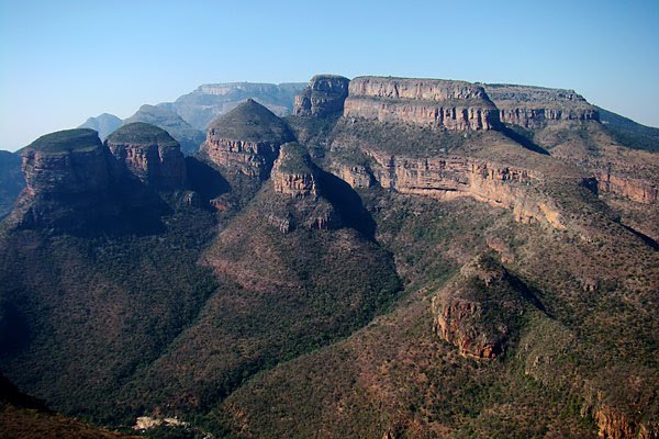

Africa is located on one African plate. The African plate is moving northeast, colliding with the Eurasian plate. The consequence of this collision is the formation of the young Atlas Mountains in northern Africa. Further plate collisions will likely lead to extinction in the future. Mediterranean Sea and the transformation of Africa and Eurasia into a single continent. At the same time, in the area of the Red Sea, the processes of its expansion and the formation of new oceanic crust are observed. In the future, the Red Sea will become a new ocean. However, the African Plate itself is not completely stable. On its surface, the processes of breaking into two parts are clearly traced - in the area of the Great African faults in the southeast of the continent. A large number of earthquakes and volcanic eruptions are now recorded on the territory of the faults. Within 10 million years, a fault will form in the Ethiopian Highlands, comparable to the Red Sea. Some of the tectonic faults are now filled with water - first of all, these are lakes Nyasa and Tanganyika, as well as many other lakes in the region.
Africa is on one single African platform, formed during the Archean period. In the south of the mainland there are the old Cape and Drakensberg mountains, significantly destroyed, in contrast to the continuing formation of the Atlas. In general, in Africa, two main regions can be distinguished: the North-West Plains and the South-East - Mountainous. The average height of the mainland is 750 meters. The plateaus cover very large areas, while the lowlands are very few. The lowest point on the mainland is Lake Assal, the height of its depression is 157 meters above sea level. The most high point- Kilimanjaro volcano, 5895 meters high.
Volcanoes and earthquakes are quite common in Africa. In addition to Kilimanjaro, there are such volcanoes as Karisimbi (4507 m) and Cameroon (4100 m) (pictured). Earthquakes occur both in northern Africa, where the border with the Euro-Asian lithospheric plate passes, and in the east of the mainland - in the area of tectonic faults and the Red Sea.
Africa is known for its richest deposits of diamonds (South Africa, Zimbabwe) and gold (South Africa, Ghana, Mali, Republic of Congo). There are oil fields in Algeria, Libya, on the shelf of the Gulf of Guinea - in Nigeria. bauxite is mined in Guinea and Ghana. Resources of phosphorites, as well as manganese, iron and lead-zinc ores are concentrated in the area of the northern coast of Africa. Large reserves of copper ores are concentrated in Zambia.
Mainland climate

Equatorial belt Africa is located on the shores of the Gulf of Guinea and stretches inland to Lake Victoria. The equatorial air mass dominates here all year round, so there are no seasons of the year, it is constantly hot here, and very often there are heavy rains. Due to abundant moisture (2-3 mm per year) and a very warm climate (above + 20 ° - + 30 ° C throughout the year), a natural zone of humid equatorial forests has formed here. An unimaginable number of animal and plant species are concentrated in the forests of Africa, many of which are still unknown to science. The interior regions of the equatorial belt remain unpopulated as before.
Subequatorial belt Surrounds the equatorial from the north, east and south. In contrast, there is no longer year-round rains here, but a pronounced rainy and dry seasons appear. In summer, the belt is dominated by the equatorial air mass, bringing the rainy season. The amount of precipitation and the length of this season decrease with distance from the equator. In areas of the mainland, where the season lasts most of the year, variable moist forests, in the same place where the rainy season lasts less than six months, the precipitation is no longer enough for the development of woody vegetation - there are woodlands and savannas. It is worth noting that summer in Africa falls on June-August in the northern hemisphere and December-February in the southern, because when in one part subequatorial belt there is a rainy season, in the opposite tropical air mass dominates - that is, a dry season begins.
Tropical belt Africa is clearly divided into northern and southern. Here the weather is clear all year round, and there is practically no rain. The amount of precipitation decreases with distance inland. Since a very large area of Africa is located precisely in the northern tropical latitudes, optimal conditions for the formation of deserts are formed here - dry air, increased pressure due to tropical air mass and remoteness from the ocean. That is why Africa is considered the continent of classical desert development. In addition to the aridity of the tropics of Africa, huge temperature differences should be noted here. In summer, when the Sun rises high, it literally heats up the sand of the desert, and the air temperature rises above 30 and even 40 degrees. The highest air temperature in Africa and around the world was recorded in the Libyan Desert and amounted to + 58 ° С. At the same time, after sunset, the temperature drops sharply by several tens of degrees, and even drops to negative values on winter nights.
Subtropical belt stretched out in a narrow strip along the northern coast of Africa, as well as in the very south of the mainland. It is also divided into north and south. In the subtropics, two air masses are replaced during the year: tropical comes in summer, because summer in the subtropics is hot and dry, and in winter temperate air comes, bringing precipitation. A natural zone of hard-leaved and evergreen forests has formed here. However, in its original form, it has practically never been preserved, since the territory of the subtropics is actively being transformed under the economic activity of man.
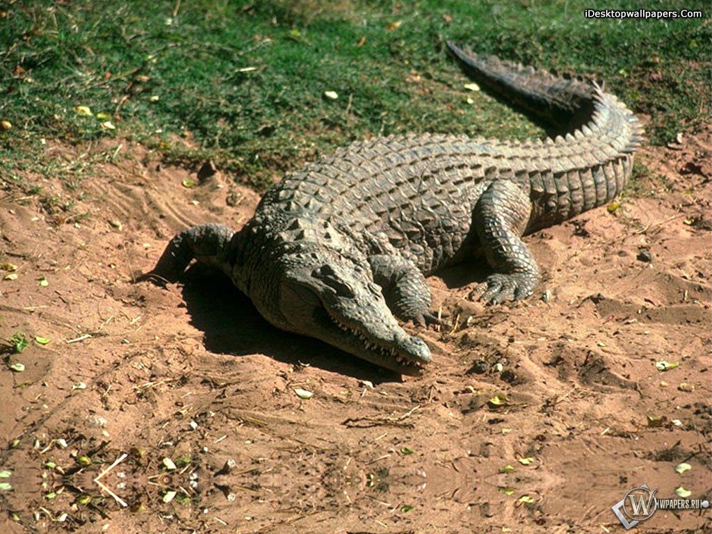
Fauna and flora of Africa

The flora of Africa has been fully studied (40,000 species and 3,700 families, of which 900 are endemic flowering plants). The boundaries and types of vegetation in Africa were determined at the end of the Pliocene, with the establishment of the modern ratio of heat and moisture. The northern part of Africa is part of the Holarctic Floristic Region. The territory of Africa south of the Sahara belongs to the Paleotropic region, in the south-west of Africa they distinguish the Cape floristic region, the Flora of the Atlas and the northern coast of Libya and South Africa belongs to the Mediterranean region of the Holarctic and there is much in common with the flora of Southern Europe (strawberry tree, pure) and Western Asia (Atlas cedar, efratska poplar). The flora of the Madeira Islands, Canary Islands and Cape Verde (mainly forest) forms the Macaronesian subregion of the Holarctic with the largest number of endemics in the Canary Islands (dragon tree, etc.). The flora of the Sahara (grass and shrub), very poor species (about 1200), lies in the North African-Indian subregion of the Holarctic.
The natural vegetation cover of Africa is largely disturbed by deforestation.
Today savannahs occupy about 37% of the area of Africa, foxes -about 16% and deserts - more than 39%. Wet evergreen equatorial forests occupy largest area along the coast of the Gulf of Guinea (from 7 ° N lat. to 12 ° S lat.) And in the Congo depression (from 4 ° S lat. to b0 S lat.) In hot and constantly humid climate... On the northern and southern outskirts, they pass into mixed (deciduous-evergreen) and deciduous forests, lose their leaves in the dry season (3-4 months). Tropical rainforests (mainly palm) grow on east coast Africa and east Madagascar; mixed deciduous-coniferous forests - in the southeastern monsoon outskirts of Africa; evergreen hardwood forests (mainly of cork oak) - on the windward slopes of the Atlas. Mountain slopes up to an altitude of 3000 m are covered by mountain forests, in the belts with the highest rainfall they are undersized, with the presence of mosses and lichens.
Savannah flank woodland Equatorial Africa and extend through Sudan, East and South Africa beyond the southern tropic. Depending on the duration of the rainy season and the annual amount of precipitation in them and level the tall-grass, typical (dry) and deserted savannas. In high May, savannas occupy a space where the annual precipitation is 800-1200 mm, and the dry season lasts 3-4 months, they have a dense cover of tall grasses (elephant grass up to 5 m), groves and massifs of mixed or deciduous forests on watersheds, gallery evergreen forests of soil moisture in the valleys. In typical savannahs (precipitation 500-800 mm, high season 6 months) continuous cereal cover no higher than 1 m (species of bearded vulture, temeda, etc.), palms (fanny, hyphaena), baobabs, acacia trees are characteristic of ancient species; in East and South Africa - milkweed. A significant part of the savannas are wet and typical savannas of secondary origin. Deserted savannas (precipitation 300-600 mm, dry season 8-10 months) have a thin grass cover, thickets of thorny bushes (mainly acacia) are common in them.
Deserts occupy the largest area in northern Africa, where the world's largest desert, the Sahara, is located. Its vegetation is extremely sparse; in the northern Sahara it is cereal-shrub, in the southern - shrub; concentrated mainly along riverbeds and on sands. The most important plant in the oases is the date palm. The subtropical marginal deserts of Africa turn into cereal-shrub semi-deserts; in the north they are typical for feather grass alpha, in the south - numerous onions. Very large and varied plant resources. In evergreen forests Central Africa up to 40 tree species grow, which have valuable wood (black, red, etc.); high-quality edible oil is obtained from the fruit of the oil palm, and caffeine and other alkaloids are obtained from the seeds of the cola tree. Africa is the birthplace of the coffee tree growing in the forests of the Ethiopian Highlands, Central Africa, Madagascar. The homeland of many cereals (including drought-resistant wheat) is the Ethiopian Highlands.
Conclusion
In conclusion, I would like to say that Africa is the second largest continent after Eurasia. Washed by the Atlantic Indian oceans, as well as the Mediterranean Sea, the Red Sea, the Gulf of Guinea, etc. Its geographical position is very attractive for tourism. The mainland covers zones of the equatorial, subequatorial, tropical, subtropical climate. Average monthly summer temperatures are about 20-25 ° C.
Flora and fauna of Africa amazes with its diversity and variety of rare, exotic species of animals and plants. There are many national parks, zoos and nature reserves on the mainland.
The historical value of countries such as Egypt, Morocco and others attracts tourists from all over the world.
The continent has the most great desert on Earth - the Sahara, the world's second largest Victoria Falls, as well as famous landmarks from the "Seven Wonders of the World."
Africa- an extremely interesting, very promising, but the most poorly developed tourist region. Among the factors favoring the development of tourism on this continent are the following:
Proximity to Europe and Asia;
Warm weather and plenty of sun all year round;
Presence in many coastal regions of Africa beautiful beaches, on the basis of which you can create sea resorts;
Diverse exotic nature, including unique wild fauna;
The factors that hinder the development of tourism in Africa include the following:
Low economic level in most African countries;
Poorly developed tourist infrastructure and transport network;
The unstable internal political situation in a number of countries on the continent; Africa. Plant and animal world // Moregeo
Africa is the hottest continent of the Earth, to which it owes its geographic location... The continent is located in four climatic zones: equatorial, subequatorial, tropical and subtropical. Africa is located between 37 ° north and 34 ° south latitude - that is, in equatorial and tropical latitudes.
Africa's equatorial belt is located on the shores of the Gulf of Guinea and stretches inland to Lake Victoria. The equatorial air mass dominates here all year round, so there are no seasons of the year, it is constantly hot here, and very often there are heavy rains. Due to abundant moisture (2-3 mm per year) and a very warm climate (above + 20 ° - + 30 ° C throughout the year), a natural zone of humid equatorial forests has formed here. An unimaginable number of animal and plant species are concentrated in the forests of Africa, many of which are still unknown to science. The interior regions of the equatorial belt remain unpopulated as before.
Subequatorial belt Surrounds the equatorial belt from the north, east and south. In contrast, there is no longer year-round rains here, but a pronounced rainy and dry seasons appear. In summer, the belt is dominated by the equatorial air mass, bringing the rainy season. The amount of precipitation and the length of this season decrease with distance from the equator. In areas of the mainland, where the season lasts most of the year, variable moist forests are formed, but where the rainy season lasts less than six months, precipitation is no longer enough for the development of woody vegetation - there are light forests and savannahs. It is worth noting that summer in Africa falls on June-August in the northern hemisphere and December-February in the southern, therefore, when the rainy season is in one part of the subequatorial belt, tropical air mass dominates in the opposite part - that is, the dry season begins.
The tropical zone of Africa is clearly divided into northern and southern. Here the weather is clear all year round, and there is practically no rain. The amount of precipitation decreases with distance inland. Since a very large area of Africa is located precisely in the northern tropical latitudes, optimal conditions for the formation of deserts are formed here - dry air, increased pressure due to the tropical air mass and remoteness from the ocean. That is why Africa is considered the continent of classical desert development. In addition to the aridity of the tropics of Africa, huge temperature differences should be noted here. In summer, when the Sun rises high, it literally heats up the sand of the desert, and the air temperature rises above 30 and even 40 degrees. The most heat air in Africa and around the world was recorded in the Libyan desert and amounted to + 58 ° С. At the same time, after sunset, the temperature drops sharply by several tens of degrees, and even drops to negative values on winter nights.
The subtropical belt stretches in a narrow strip along the northern coast of Africa, as well as in the very south of the continent. It is also divided into north and south. In the subtropics, two air masses are replaced during the year: tropical comes in summer, because summer in the subtropics is hot and dry, and in winter temperate air comes, bringing precipitation. A natural zone of hard-leaved and evergreen forests has formed here. However, in its original form, it has practically never been preserved, since the territory of the subtropics is actively being transformed under economic activities person.
- What air masses are formed on the mainland?
- In which belts atmospheric pressure is Africa? How do these pressure belts affect precipitation?
Due to its geographical position, Africa is the hottest continent on Earth. It receives more solar heat and light than any other continent. The sun during the whole year between the tropics stands high above the horizon, and twice a year, at any point, it is at its zenith. (Determine the temperatures and rainfall in different parts of the mainland. Explain why there is a lot of rainfall in the Congo Basin, but little in the Sahara.)
Climatic zones of Africa. Due to the fact that the equator crosses Africa almost in the middle, climatic zones, with the exception of the equatorial one, are repeated twice on its territory.
The equatorial belt includes part of the Congo Basin (Zaire) and the coast of the Gulf of Guinea. The equatorial climate is constant. The weather is usually clear in the morning. During the day due to strong heating of the Earth's surface by the Sun equatorial air saturated with moisture rushes upward. Cumulus clouds are forming. In the afternoon, a downpour breaks out, often accompanied by violent storms and thunderstorms. With the onset of the storm, the trees, which had stood so calmly before, frantically rush from side to side: in horror, they seem to want to jump out of place, but strong roots hold their powerful trunks. Lightning storms swirling clouds, which, having thickened to blackness, for the last time cover the neighborhood with white light, the rain bursts with tropical fury, everything turns into chaos. But after a few minutes, the downpour seems to extinguish all this firestorm, and when it ended, the forest is already quiet and majestic again. By evening, clear weather sets in again.
Rice. 54. Climate map... Identify the hottest and wettest, coldest and driest parts of the mainland. Explain their placement
Belt equatorial climate it is framed by a wide strip of the subequatorial belt, which reaches approximately 15-20 ° latitude north and south of the equator. You already know that there are two seasons here - dry winters and wet summers. With the arrival of the zenital position of the Sun, the rainy time sets in. It begins suddenly, immediately, and within three weeks the savannah is flooded with huge streams of water. Water occupies all crevices, depressions and saturates the parched earth. The swamps are overflowing with water, and all the lowlands turn into lakes. As if by magic, the savannah is covered with luxurious grass.
Summer rainfall and the length of the rainy season decrease towards the tropics.
Tropical belts match tropical latitudes both hemispheres.
Determine their geographic location on the map. What air masses and winds prevail here throughout the year? What kind of weather do they condition?
Driest in North Africa... (Explain why.) Here is the hottest and driest region of not only Africa, but the entire Earth - the Sahara Desert. Summer in the Sahara is extremely hot, the sky is almost cloudless. The sun heats the surface of stones and sand to 70 ° C, the air temperature rises to 40 ° C and higher. Due to the absence of clouds at night, the surface of the earth and the air cool rapidly. Therefore, fluctuations in daily temperatures are very large. It is difficult to breathe hot dry air during the day. All living things are hiding in the crevices of stones, in the roots of dried herbs, and the desert seems to be dead. In summer, the strongest wind often blows - samum, carrying clouds of sand. The dunes come to life before our eyes, the horizon fades, the dust covers the sun, among the reddish haze it looks like a ball of fire. It becomes unbearably stuffy, people and animals suffocate. The mouth, nose and eyes are clogged with sand. Trouble is for those who do not hide from the storm in time.
Rice. 55. Climatograms of the subtropical zone
In South Africa, the tropical climate zone is spread over a smaller area. Due to the shorter length from west to east, precipitation falls here more than in the Sahara, especially on the eastern slopes of the Drakensberg mountains, in the east of Madagascar, where precipitation is brought from the ocean by southeasterly winds. However on the coast Atlantic Ocean it almost never rains. The cold currents of the Atlantic Ocean, passing off the southwestern coasts, lower the air temperature in the coastal part of the continent and do not favor rainfall. Cold air, as you know, becomes heavier, denser, cannot rise, form clouds and give precipitation. The only source of moisture here is dew, which forms when the temperature drops.
The extreme north and south of the mainland, as you know, are in subtropical zones... Hot (+ 27-28 ° С) dry summers, relatively warm winter(+ 10-12 ° С) are favorable for human life and economic activity.
The large amount of heat received by Africa favors the cultivation of valuable tropical crops: coffee, cocoa, date and oil palms, pineapples, bananas, etc.
- Using climatic, physical maps as well as climatic charts, compare equatorial, subequatorial and subtropical climates according to plan (see appendix).
- Use Figure 54 to describe the climate of Madagascar.


