Introduction
Conclusion
Introduction
The Earth is part of a system where the center is the Sun, which contains 99.87% of the mass of the entire system. A characteristic feature of all planets Solar system is their shell structure: each planet consists of a number of concentric spheres, differing in the composition and state of matter.
The Earth is surrounded by a powerful shell of gas - the atmosphere. It is a kind of regulator of exchange processes between the Earth and Space. In the composition of the gas envelope, several spheres are distinguished, differing in composition and physical properties. The bulk of the gaseous substance is contained in the troposphere, the upper boundary of which, located at an altitude of about 17 km at the equator, decreases to the poles to 8-10 km. Above, along the stratosphere and mesosphere, the rarefaction of gases increases, and thermal conditions change difficult. At an altitude of 80 to 800 km, the ionosphere is located - a region of highly rarefied gas, among the particles of which electrically charged ones predominate. The outermost part of the gas envelope is formed by the exosphere, which extends to an altitude of 1800 km. The lightest atoms - hydrogen and helium - dissipate from this sphere.
The planet itself is even more complexly stratified. The mass of the Earth is estimated at 5.98 * 1027 g, and its volume is 1.083 * 1027 cm 3. Consequently, the average density of the planet is about 5.5 g / cm 3. But the density of the rocks available to us is 2.7-3.0 g / cm 3. It follows from this that the density of the Earth's matter is inhomogeneous.
The main methods of studying the inner parts of our planet are geophysical, primarily observing the speed of propagation of seismic waves generated from explosions or earthquakes. Just as waves from a stone thrown into water radiate in different directions along the surface of the water, so elastic waves propagate in a solid substance from the source of the explosion. Among them, the waves of longitudinal and transverse vibrations are distinguished. Longitudinal vibrations are alternations of compression and extension of a substance in the direction of wave propagation. Lateral vibrations can be thought of as alternating shifts in the direction perpendicular to the wave propagation.
Waves of longitudinal vibrations, or, as they say, longitudinal waves, propagate in a solid at a higher speed than transverse ones. Longitudinal waves propagate in both solid and liquid matter, transverse - only in solid. Consequently, if during the passage of seismic waves through any body it is found that it does not transmit transverse waves, then we can assume that this substance is in a liquid state. If both types of seismic waves pass through the body, then this is evidence of a solid state of matter.
The speed of the waves increases with increasing density of the substance. With a sharp change in the density of matter, the speed of the waves will change abruptly. As a result of studying the propagation of seismic waves through the Earth, it was found that there are several definite boundaries of the jump-like change in wave velocities. Therefore, it is assumed that the Earth consists of several concentric shells (geospheres).
Based on the established three main boundaries, three main geospheres are distinguished: the earth's crust, mantle and core.
The first interface is characterized by an abrupt increase in the velocities of longitudinal seismic waves from 6.7 to 8.1 km / s. This boundary was called the section of Mohorovicic (in honor of the Serbian scientist A. Mohorovicic, who discovered it), or simply the border of M. It separates the earth's crust from the mantle. Density of matter crust, as indicated above, does not exceed 2.7-3.0 g / cm 3. The M boundary is located under the continents at a depth of 30 to 80 km, and under the oceans, from 4 to 10 km.
Considering that the radius of the globe is 6371 km, the earth's crust is a thin film on the planet's surface, making up less than 1% of its total mass and approximately 1.5% of its volume.
earth crust mineral
1. The earth's crust and types of its structure
The structure of the earth's crust. The earth's crust is a term, although it entered natural science in the Renaissance, for a long time it was interpreted very freely due to the fact that it was impossible to directly determine the thickness of the crust and study its deep parts. The discovery of seismic vibrations and the creation of a method for determining the speed of propagation of their waves in media of different densities gave a powerful impetus to the study of the earth's interior. With the help of seismographic studies at the beginning of the XX century. a fundamental difference in the speed of passage of seismic waves through the rocks that compose the earth's crust and the material of the mantle was discovered, and the boundary between them (the Mohorovichich boundary) was objectively established. Thus, the concept of "earth's crust" has received a specific scientific justification.
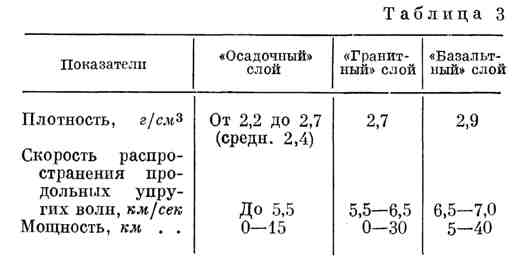
Experimental study of the rate of distribution of shock elastic vibrations in rocks with different densities, on the one hand, and on the other hand, "transmission" of the earth's crust by seismic waves at many points the earth's surface, made it possible to find that the earth's crust consists of the following three layers, composed of rocks of different densities:
1.) The outer layer, consisting of sedimentary rocks, in which seismic waves propagate at a speed of 1-3 km / sec, which corresponds to a density of about 2.7 g / cm 3. Some scientists call this layer the sedimentary shell of the Earth.
2.) A layer of dense crystalline rocks that compose the upper part of the continents under the sedimentary strata, in which seismic waves propagate at a speed of 5.5 to 6.5 km / s. Due to the fact that longitudinal seismic waves propagate at a specified speed in granites and rocks close to them in composition, this stratum is conventionally called a granite layer, although it contains a wide variety of igneous and metamorphic rocks. Granitoids, gneisses, crystalline schists predominate; crystalline rocks of intermediate and even basic composition (diorites, gabbros, amphibolites) are found.
3.) A layer of denser crystalline rocks that forms the lower part of the continents and composes the ocean floor. In the rocks of this layer, the velocity of propagation of longitudinal seismic waves is 6.5-7.2 km / s, which corresponds to a density of about 3.0 g / cm 3. Such speeds and density are characteristic of basalts, due to which this layer was called basaltic, although basalts do not completely compose this layer everywhere.
As you can see, the concepts "granite layer" and "basalt layer" are conditional and are used to designate the second and third horizons of the earth's crust, characterized by the velocities of propagation of longitudinal seismic waves, respectively, 5.5-6.5 and 6.5-7.2 km / s ... In the future, these names will be given without quotation marks, but you must remember about their conventions.
The lower boundary of the basalt layer is the Mokhorovich surface. Below there are rocks belonging to the material of the upper mantle. They have a density of 3.2-3.3 g / m 3 and more, the velocity of propagation of longitudinal seismic waves in them is 8.1 m / s. Their composition corresponds to ultrabasic rocks (peridotites, dunites).
It should be noted that the terms "crust" and "lithosphere" (stone shell) are not synonyms and have different meanings. The lithosphere is the outer shell of the earth, composed of hard rocks, including rocks of the upper mantle of ultrabasic composition. The earth's crust is a part of the lithosphere that lies above the border of Mohorovichich. Within the indicated boundaries, the total volume of the earth's crust is more than 10 billion km 3, and the mass is over 1018 tons.
Types of structure of the earth's crust. When studying the earth's crust, its unequal structure was found in different regions. Generalization of a large amount of factual material made it possible to distinguish two types of the structure of the earth's crust - continental and oceanic.
For continental type characterized by a very significant thickness of the crust and the presence of a granite layer. The boundary of the upper mantle is located here at a depth of 40-50 km and more. The thickness of the sedimentary rock strata in some places reaches 10-15 km, in others - the stratum may be completely absent. The average thickness of sedimentary rocks of the continental crust is 5.0 km, of the granite layer - about 17 km (from 10-40 km), basalt - about 22 km (up to 30 km).
As mentioned above, the petrographic composition of the basaltic layer of the continental crust is variegated and most likely it is dominated not by basalts, but by metamorphic rocks of the basic composition (granulites, eclogites, etc.). For this reason, some researchers suggested calling this layer granulite.
The thickness of the continental crust increases over the area of mountain-folding structures. For example, on the East European Plain, the thickness of the crust is about 40 km (15 km is a granite layer and more than 20 km is a basalt layer), and in the Pamirs it is one and a half times greater (about 30 km in total are a thickness of sedimentary rocks and a granite layer and the same basalt layer). The continental crust is especially thick in mountainous areas located at the edges of the continents. For example, in the Rocky Mountains (North America), the crustal thickness is much greater than 50 km. The earth's crust, which composes the bottom of the oceans, has a completely different structure. Here, the thickness of the crust is sharply reduced and the material of the mantle comes close to the surface. There is no granite layer, the thickness of the sedimentary strata is relatively small. The upper layer of unconsolidated sediments is distinguished with a density of 1.5-2 g / cm 3 and a thickness of about 0.5 km, a volcanic-sedimentary layer (interlayering of loose sediments with basalts) with a thickness of 1-2 km and a basalt layer, the average thickness of which is estimated at 5 -6 km. At the bottom The Pacific the earth's crust has a total thickness of 5-6 km; at the bottom of the Atlantic Ocean, under a sedimentary layer of 0.5-1.0 km, there is a basalt layer 3-4 km thick. Note that the crustal thickness does not decrease with increasing ocean depth.
At present, there are also transitional subcontinental and suboceanic crustal types corresponding to the submarine margin of the continents. Within the crust of the subcontinental type, the granite layer is greatly reduced, which is replaced by a layer of sediments, and then, towards the Ocean floor, the thickness of the basalt layer begins to decrease. The thickness of this transitional zone of the earth's crust is usually 15-20 km. The boundary between the oceanic and subcontinental crust runs within the continental slope at a depth interval of 1 -3.5 km.
Although the oceanic crust occupies a larger area than the continental and subcontinental, due to its small thickness, only 21% of the volume of the earth's crust is concentrated in it. Volume and weight information different types the earth's crust are shown in table 1.
Table 1
Volume, thickness and mass of horizons of different types of the earth's crust (compiled according to the data of A.B. Ronov and A.L. Yaroshevsky. 1976)
The earth's crust lies on the subcrustal mantle substrate and accounts for only 0.7% of the mantle mass. In the case of a low crustal thickness (for example, on an oceanic bed), the uppermost part of the mantle will also be in a solid state, which is usual for rocks of the earth's crust. Therefore, as noted above, along with the concept of the earth's crust as a shell with certain indices of density and elastic properties, there is the concept of the lithosphere - a stone shell, thicker than a solid that covers the surface of the Earth.
Structures of types of the earth's crust. The types of the earth's crust also differ in their structures. The oceanic crust is characterized by a variety of structures. On the central part of the bottom of the oceans, powerful mountain systems- mid-ocean ridges. In the axial part, these ridges are dissected by deep and narrow rift valleys with steep sides. These formations are zones of active tectonic activity. Deep-sea trenches are located along the island arcs and mountain structures on the outskirts of the continents. Along with these formations, there are deep-water plains that occupy vast areas.
Equally heterogeneous is the continental crust. Within its limits, it is possible to distinguish young mountain-folding structures, where the thickness of the crust as a whole and of each of its horizons greatly increases. Areas are also distinguished where crystalline rocks of the granite layer represent ancient folded areas, leveled over a long geological time. Here, the crustal thickness is much less. These vast stretches of continental crust are called platforms. Inside the platforms, there are shields - areas where the crystalline basement goes directly to the surface, and plates, the crystalline base of which is covered with a layer of horizontally lying sediments. An example of a shield is the territory of Finland and Karelia (Baltic shield), while in the East European Plain, the folded basement is deeply submerged and overlain by sedimentary deposits. The average thickness of sediments on the platforms is about 1.5 km. Mining structures are characterized by a significantly greater thickness of sedimentary rocks, the average value of which is estimated at 10 km. The accumulation of such thick deposits is achieved by prolonged gradual subsidence, subsidence of individual sections of the continental crust, followed by their uplift and folding. Such sites are called geosynclines. These are the most active zones of the continental crust. About 72% of the total mass of sedimentary rocks are confined to them, while about 28% are concentrated on the platforms.
The manifestations of magmatism on platforms and geosynclines are sharply different. During the periods of subsidence of geosynclines, magma of basic and ultrabasic composition is supplied along deep faults. In the process of transformation of a geosynclinal into a folded area, huge masses of granite magma are formed and introduced. The later stages are characterized by volcanic eruptions of lavas of intermediate and felsic composition. On the platforms, magmatic processes are much less pronounced and are represented mainly by outpourings of basalts or lavas of alkaline-basic composition.
Clays and shales prevail among the sedimentary rocks of the continents. At the bottom of the oceans, the content of calcareous sediments increases.
So, the earth's crust consists of three layers. Its upper layer is composed of sedimentary rocks and weathering products. The volume of this layer is about 10% of the total volume of the earth's crust. Most of the substance is located on the continents and the transition zone, within the oceanic crust it is not more than 22% of the layer volume.
In the so-called granite layer, the most common rocks are granitoids, gneisses and crystalline schists. More basic rocks account for about 10% of this horizon. This circumstance is well reflected in the average chemical composition of the granite layer. When comparing the values of the average composition, attention is drawn to the clear difference between this layer and the sedimentary strata (Table 2).table 2
Chemical composition of the earth's crust (in weight percent)
(according to L.B. Ronov and A.L. Yaroshevsky, 1976)
The composition of the basalt layer in the two main types of the earth's crust is not the same. On the continents, this stratum is characterized by a variety of rocks. There are deeply metamorphosed and igneous rocks of basic and even acidic composition. Basic rocks make up about 70% of the total volume of this layer. The basalt layer of the oceanic crust is much more homogeneous. The predominant type of rocks is the so-called tholeiitic basalts, which differ from continental basalts in their low content of potassium, rubidium, strontium, barium, uranium, thorium, zirconium and a high Na / K ratio. This is due to the lower intensity of differentiation processes during their fusion from the mantle. Ultrabasic rocks of the upper mantle emerge in deep reef faults.
The abundance of rocks in the earth's crust, grouped to determine the ratio of their volume and mass, is shown in Table 3.
Table 3
The prevalence of rocks in the earth's crust
(after A.B. Ronov and A.L. Yaroshevsky, 1976)
2. Evolution of the chemical composition of the earth's crust
The problem of the formation of the existing structure of the earth's crust is not only of fundamental theoretical importance. Cognition of the processes that form the earth's crust, at the same time, means finding out the patterns of formation and location of industrial deposits of minerals. Therefore, large scientific teams of many countries are working on the study of these processes.
Experimental research, study of rocks on the surface of continents and at the bottom of the oceans, results deep drilling made it possible to develop an idea of the radially directed straightening and degassing of the earth's crust material from the mantle. The substance of the mantle has not yet been directly subjected to chemical analysis, since it is still technically impossible to get it. However, there is reason to believe that the composition of the mantle corresponds to the composition of stony meteorites (chondrites).
The results of analyzes show that they contain certain amounts of some chemical elements that form relatively low-melting compounds, as well as elements that make up gases and water (Table 4).
Table 4
(after A.P. Vinogradov, 1964)
Mantle substance is in an equilibrium solid state under conditions high temperatures and pressure. However, this equilibrium state will be violated if the external conditions change, for example, the pressure drops or the temperature rises. Then the substance will go into a molten, liquid state. Such a phenomenon is quite probable if a strong heating center arises inside the mantle. It can be caused by the energy of radioactive decay. The molten mass containing a source of thermal energy will move in a radial direction to the Earth's surface, melting the mantle material during its movement. In this case, a natural differentiation of this substance should occur.
To imagine the mechanism of this process, mentally do the following experiment.
We place a mixture of compounds with different melting points in a heat-resistant tube. Using the ring heater, melt the narrow area at the bottom of the tube and then slowly move the heater upward along the tube. As the heater rises, the next zone will melt, and the underlying mass will cool down and re-crystallize. As the heater moves, all the substance in the tube will go through the stages of melting and subsequent crystallization. If this operation is repeated several times, then the initial mixture will naturally separate: more low-melting compounds will separate at the top, and less melting ones at the bottom.
The stated principle of "zone" smelting was used by the well-known geochemist A.P. Vinogradov to create a model for the formation of the earth's crust. According to this model, certain centers of melt moving in the radial direction ensured the regular differentiation of the mantle material. The composition of the initially formed melt did not differ from the composition of the starting material. But the repeated repetition of this process led to the separation of matter, the removal from mania of relatively low-melting compounds and their accumulation on the surface of the planet.
As a result of the differentiation of the initial substance, there is a regular redistribution of chemical elements over the shells of the Earth. If we assume that the composition of the initial material of the mantle is close to the composition of stony meteorites, then we can trace how the content of the most important chemical elements changed during the formation of the earth's crust.
Table 5 clearly shows that the release of low-melting compounds from the original matter of the planet was accompanied by a progressive accumulation of silicon, aluminum, calcium, potassium, sodium, fluorine, chlorine. At the same time, most of the iron, magnesium, sulfur remained in the material of the mantle.
Other models have also been proposed, but regardless of any ideas about the mechanism of mass transfer, most scientists share the opinion that the earth's crust was formed by the removal of fusible and highly volatile chemical compounds from the mantle.
Table 5
(according to A.P. Vinogradov)
The process of removal of highly volatile and low-melting chemical compounds is very complicated. While the formation of the basalt crust as a product of melting from the mantle material is not in doubt, in the process of the formation of the granite layer there is still a lot that is unclear. Numerous facts indicate that the formation of large masses of granites is confined to a certain stage in the development of geosynclines, at which the processes of regional metamorphism reach their highest degree - palingenesis. In this case, the melting of metamorphosed rocks occurs under the influence of not only high temperatures and pressure, but also deep fluids degassed from the mantle. The resulting melt is saturated with chemical elements supplied as a result of degassing, its composition becomes more complex in comparison with melted basalts pouring out on the ocean floor from deep faults. The considered process is called granitization. It is possible that in this way huge masses of granite batholiths were formed.
The active removal of volatile compounds that cause the granitization of thick sediments does not occur everywhere on the surface of the globe, but only in certain structural elements of the earth's crust - geosynclines. The localization of the processes of active removal, apparently, is associated with the uneven distribution of energy sources, in particular, the masses of radioactive elements in the mantle. Thus, the continents, whose crust contains a granite layer, can be considered as areas of the earth's crust, within which the removal of highly volatile and low-melting chemical compounds from the mantle took place especially actively. In the area of distribution of the oceanic crust, this process was less active, as evidenced not only by the lower thickness of the layer of melted basalts, but also by the poverty of oceanic basalts in many chemical elements in comparison with the basalts of the continental crust. According to the calculations of A.B. Ronov and A.A. Yaroshevsky, the total mass of matter carried from the mantle into the continental crust is 22.37 * 10 18 tons, and into the oceanic crust is almost four times less.
The process of formation of the continental crust was especially important for the redistribution of metals. As follows from the data in Table 6, the content of some metals sharply increases in the granite layer in comparison with the initial material of the mantle,
Table 6
Redistribution of some rare and scattered chemical elements during the formation of the earth's crust, in 1-10 -3%
while the content of others is reduced. In the process of melting the material of the earth's crust, metals of the iron group were retained in the mantle - nickel, cobalt, chromium, partly manganese. Therefore, the content of nickel in the rocks of the upper horizons of the Earth's crust, in comparison with the content in the original material, decreases tens of times, the content of cobalt and chromium decreases about a hundred times, and a thousand times of platinum. In the process of melting the earth's crust, the content of mercury also decreased, but this was due to the removal of vapors of this metal, which entered the atmosphere and dissolved in natural waters.
Metals, the content of which generally increases in the earth's crust, are distributed unevenly in rocks. A group of metals is distinguished, concentrated in the granite layer of the continental crust, enriched in silicon, aluminum, alkalis, and highly volatile compounds. These include zirconium, niobium, barium, tin, lead, uranium. For example, the concentration of lead increases 100 times, uranium - even more. Another group of metals is concentrated in basalt rocks. This group includes titanium, vanadium, copper, zinc.
Simultaneously with the melting of low-melting compounds from the material of the mantle, gases of various substances were released. As a result of degassing the mantle, the bulk of the gases and water available on our planet were formed. At the same time, calculations show that over the course of geological history, only about 10% of each gas contained in it was removed from the mantle. So, for example, according to A.P. Vinogradov, the water content in the mantle is 2 * 10 22 kg, and its total amount in the hydrosphere and atmosphere is 1.5 * 10 21 kg. Sublimated heavy metal compounds were also removed as a result of the degassing process.
A very special position in the earth's crust is occupied by the outermost layer, which some scientists call the sedimentary shell of the Earth. In terms of mineralogical composition, it is fundamentally different from the other two layers of the crust. The composition of the sedimentary shell is dominated by non-silicates with a varied crystal-chemical structure, as in the granite and basalt layers of the earth's crust, and dispersed silicates with a complex structure are clays, which make up 40% of the sedimentary layer, carbonates - 23%. Among the clastic minerals preserved during the hypergene transformation of the granite layer, which are part of the sedimentary shell and make up 19% of its mass, quartz, the most resistant to weathering endogenous mineral, dominates. The chemical composition of the sedimentary layer is enriched not only in H 2 O and CO 2, but also in oxidized forms of sulfur, organic carbon, chlorine, fluorine, nitrogen and heavy metals. All these compounds and elements are removed from the mantle by degassing, but in the process of hypergenesis and sedimentogenesis they bind and accumulate in the material of the sedimentary layer. Thus, on the surface of the Earth, a deep transformation of the substance of the granite layer takes place. The main factor of this process is the total geochemical effect of the vital activity of organisms. This is manifested both in the direct participation of organisms in sediment formation and in the regulation of conditions that determine the direction of the transformation of rocks in the granite layer: the content of oxygen and carbon dioxide in the atmosphere, the alkaline-acid parameters of natural waters, redox conditions, the presence of organic compounds, etc. It has been established that most of the mass of sedimentary rocks formed over the past 600 million years is located within the continental crust, and about half of this mass is concentrated in geosynclines. The formation of metamorphic rocks of ancient shields - the main fragments of the granite layer - also took place in tectonically active structures. It can be assumed that many features of the granite layer are complexly related to the total geochemical effect of the vital activity of organisms in the geological past. With this in mind, V.I. Vernadsky called the granite layer of the earth's crust "traces of bygone biospheres."
3. Formation of the mineralogical diversity of the earth's crust
The earth's crust is composed of natural chemical compounds- minerals, the number of species of which is slightly more than 2 thousand. The limited number of natural chemical compounds in comparison with a much larger number of artificial compounds is due to many reasons, the main of which is the very uneven content of various chemical elements in the earth's crust. The range of the average content of various chemical elements reaches six mathematical orders.
The largest number mineral species form the elements contained in the earth's crust in the greatest amount. These include oxygen, silicon, aluminum, iron, calcium, magnesium, potassium, sodium. These elements form a group of compounds, the masses of which in the greatest amount were melted from the mantle.
Along with them, significant amounts of minerals are formed by such elements as sulfur, arsenic, antimony, copper, lead, zinc and some other metals, which were actively removed during the degassing of the mantle material.
Table 7
Formation of minerals during the main processes of mineral formation
If we consider the diversity of mineral formation during various endogenous processes, then the largest number of mineral species is formed during processes that take place with the participation of degassing products. Minerals formed during pneumatolytic-hydrothermal and pegmatite processes, according to the calculations of the famous Ukrainian mineralogist E.K. Lazarenko, make up about 30% of all mineral species. An even greater amount of mineral substances arises during the processes of hypergenesis and sedimentation, in which, under the geochemical control of the total effect of the vital activity of organisms, chemical compounds of degassed elements that enter the atmosphere and hydrosphere are formed (Table 7).
Certain regularities are found in the variety and distribution of the mass of minerals by classes. Some data were given when describing mineral groups, their general summary is presented in Table 8.
The data in this table make it possible, first of all, to mark the most numerous classes. Despite the discrepancies in the results of calculations by different authors, it is quite obvious that the largest amount of minerals is characteristic of silicates. The composition of the class of phosphates and their analogs is very diverse, which occupy the second place in terms of the number of minerals (17.7% - 16.4%), as well as the class of sulfides and similar compounds (9.4-13.0%), oxides and hydroxyls. (9.4-12.5%), sulfates (9.0-12.2%). The composition of other classes is less numerous and amounts to a few percent or even fractions of a percent, such as, for example, minerals of the chromate class.
Table 8
Relationship between individual classes of minerals and their content in the earth's crust
Mineral classes |
Minerals | |||||
number |
in% to the total amount of minerals | |||||
| I 1 | II 2 | I | II | I | II | |
Native elements Sulfides and the like Halides Oxides and hydroxides Silicates Sulphates Phosphates, arsenates, vanadates Carbonates Tungstates and Molybdates Organic compounds |
not taken into account |
does not mean. will appoint. |
||||
| Total | 1500 2135 100,0 100,0 100,0 99,85 | |||||
I 1 - data of E.K. Lazarenko, 1963 II 2 data of N.I.Safronov and B.A.Gavrusevich, 1968 |
||||||
The abundance of minerals of one class or another does not necessarily mean that these minerals make up a significant part of the mass of the earth's crust. Although the most diverse class of silicates predominates in the earth's crust, the second most abundant mineral class of phosphates and their analogs is less than a percent of the mass of the lithosphere (0.7%). Classes of sulphides and oxides, which are similar in number of species, differ sharply in their weight content in the earth's crust: the former are in the amount of 0.15% (according to V.I.Vernadsky), the latter - 17% of the crust mass. It should be noted that the values of the masses of minerals in the earth's crust are not precisely established and are determined by different scientists by different values. So, even for a group of predominant minerals - silicates - very different values were calculated. The American geochemist G. Washington (1925) determined the mass of silicates in the earth's crust at 63%, V.I. Vernadsky (1937) - 85%, A.E. Fersman (1934) - in 74.5%, E.K. Lazarenko (1963) - in 75%, B.A. Gavrusevich and N.I. Safronov (1968) - 80%, A.B. Ronov and A.A. Yaroshevsky (1967) - 83%. The latter figure appears to be the most reliable.
The formation of a mass of representatives of some classes is associated mainly with one specific process of mineral formation. As the data of E.K. Lazarenko, most of the minerals of the sulfide class (89%) are of pneumatolytic-hydrothermal origin and only 5% arise during lithogenesis. Wolframites and molybdates are equally divided between hypergene and pneumatolytic-hydrothermal genesis. Some classes are characterized by the emergence of a predominant amount of mineral species during the processes of hypergene mineral formation. These are sulfates, phosphates and related compounds, nitrates.
Conclusion
As geology developed, ideas about the earth's crust, its material composition and formation gradually changed from naive ideas about a frozen slag crust on the surface of a fiery-liquid metal ball to the creation of complex models of the formation of the earth's crust as a result of repeated processing of accumulations of low-melting and volatile substances carried away by heat flows from the mantle.
For a long time, the accumulation of geological knowledge took place in two almost unrelated paths. On the one hand, to solve various practical problems, minerals, ores, rocks were studied, i.e. constituent parts of the earth's crust. In this direction were made important discoveries and accumulated experience that contributed to the development of not only mineralogy, but also other sciences and branches of human activity. The accumulated experience contributed to the formation of mineralogy and related geological sciences, as well as chemistry and metallurgy.
On the other hand, thanks to the observations of naturalists, a huge amount of material was collected that characterizes various geological processes: the geological activity of seas and rivers, glaciers and volcanoes, etc. Particular attention was paid to identifying the processes of formation and the age ratio of various sediments, which almost completely cover the land and which the geologist first of all encounters in his work.
At the same time, the researchers sought to understand the processes of formation of various precipitation and to find out their age ratios. V early XIX v. the famous English geologist C. Lyell showed that sediments formed in the distant geological past are the result of the same processes that are occurring at the present time. A little earlier, his compatriot W. Smith established that the relative geological age of the studied sediments, regardless of their geographic location, can be determined using the fossilized remains of organisms that existed during the deposition of these sediments. These fundamental discoveries were the theoretical basis for the unfolding study of the geological structure of various territories.
At the same time, the conditions of occurrence of rocks of deep origin were studied. In the middle of the XIX century. a method for studying dense rocks under a microscope was developed, which opened the world of crystallization and metasomatic processes that were previously inaccessible for study, occurring during the formation of magmatic and metamorphic rocks, ores and pneumatolytic-hydrothermal formations. In the second half of the XIX century. the synthesis of the achievements of mineralogy, petrography and ore art begins with the results of studying the geological structure of individual regions of the world. On this basis, Russian, American, French geologists create the first hypotheses of the formation and structure of large geotectonic elements of the earth's crust - geosynclines, platforms, crystalline shields and plates. In 1881, the Austrian geologist E. Suess introduced the term "earth's crust" into the scientific lexicon, and in the countries Western Europe methods are being developed for studying the earth's interior by registering the speed of propagation of seismic will.
The first decades of the XX century. are marked by the discovery of the boundaries of the division of the earth's crust and mantle and the regularities of the vertical structure of the crust of continents and oceans. Mineralogy and petrography from descriptive sciences are gradually turning into genetic ones, studying the processes of formation of minerals and rocks. A new science has arisen - geochemistry, which studies at the atomic level the evolution of the chemical composition of matter on the Earth and the earth's crust, establishing the laws governing the migration of chemical elements during geological processes. Based on the achievements of physics and physical chemistry, new methods of studying the matter of the earth's crust and experimental modeling of the processes of formation and transformation of rocks under conditions of high temperatures and pressures are rapidly developing.
Until the middle of the XX century. geological research was limited to the boundaries of the land and its underwater margin. Since the end of the 50s. work is underway to study the structure of the ocean floor and the geological processes occurring there using underwater vehicles and deep-sea drilling. New information makes significant adjustments to the views on geological structure the earth's crust and the processes that form it. In light of modern scientific advances it became clear that individual geological endo- and exodynamic processes are links in a single planetary process of the formation of the solid, liquid and gaseous outer shells of the planet. The grandiose process of removal of fusible and gaseous substances from the mantle does not occur evenly over the entire surface of the earth, but is regulated by powerful heat flows generated by energy sources that form thickenings in the depths of the mantle.
Radial fluxes of heat energy and carried substances determine the formation of global structures of the earth's crust. Basalts, pouring out in the active mid-ocean ridges, form a relatively thin layer, under which the solid mantle material is located, represented by rocks of ultrabasic composition. There is reason to believe that the solid shell with such a composition is dismembered into large fragments - lithospheric plates, which move along the surface of the plastic masses of the mantle. These fragments, under the influence of convective movements of the mantle matter masses, can sink under powerful blocks. continental crust or interact with them on contact. In both cases, fragments of the oceanic crust again end up in the mantle and again undergo melting and degassing processes. Thus, the formation of the composition of matter and structures of the oceanic crust occurs against the background of a cyclic process of mass transfer in the system of the earth's crust - upper mantle. This system is stationary, but not closed, since they are involved in different time unequal masses, and open, because the cyclic process includes not only the masses of the basalt layer of the oceanic crust, but also rocks of the upper mantle, areas of the continental crust and marine sediments.
Even more difficult is the formation of the continental crust, in which a thick granite layer is located above the basalt layer. In the formation of the substance of this layer, which consists not only of low-melting compounds, but also of minerals rich in highly volatile chemical compounds, there is still much unclear. Nevertheless, it can be assumed that the processes of deep metamorphism of thick sedimentary strata accumulated in specific structures of the continental crust - geosynclines - were of great importance in its formation. It should be noted that the presence of volatile compounds that distinguish the granite layer from the basalt layer of the oceanic crust melted from the mantle is predetermined by the composition of the sediments. It is the sedimentary shell of the Earth that is the accumulator of highly volatile products of degassing of the mantle - derivatives of carbonic, hydrofluoric, hydrochloric, boric, and sulfuric acids.
The outstanding Russian scientist V.I. Vernadsky back in the 20s. it was shown that the most powerful geochemical force acting on the Earth's surface is the effect of the total vital activity of all organisms. Under the influence of this effect, the composition of the atmosphere and natural waters changed over the course of geological history, the processes of hypergene mineral formation and sedimentation were regulated, i.e. the formation of the substance that enters geosynclines and undergoes metamorphism and granitization.
The meaning of V.I. Vernadsky was realized only in the last decades of the XX century. The contribution of biogenic processes to the formation of the granite layer has not yet been sufficiently studied, but it can be assumed that the inclusion of biogenic mineral formations in the processes of palingenesis was important for the formation of granite magma, metamorphic rocks of acid composition and the gradual build-up of granite layer structures - ancient crystalline shields and platforms.
Thus, in the continental crust, two interconnected open stationary cyclic systems of the evolution of matter are outlined: the system of the basalt layer and the system of the granite layer. The rocks of the granite layer, at the final stage of geosynclinal development, entering the biosphere, undergo hypergene transformation occurring in landscape-geochemical conditions controlled by biogenic factors, and the resulting weathering products undergo further biogenic transformation during sedimentation. A significant part of continental sediments accumulates in geosynclines, where their metamorphic transformations and partial granitization take place. The formation cycle of the basalt layer of the continental crust is problematic due to the lack of deep drilling data. It can only be assumed that the substance of this layer differs significantly from the substance of the basalt layer of the oceanic crust, both in mineralogical composition and in the high content of volatile compounds.
At the end of the consideration of the idea of cyclic formation of the earth's crust, it should be noted that the thick continental crust, possibly, outlines the areas for the release of the most powerful heat fluxes and the removal of the largest masses of fusible and volatile substances from the mantle. At the same time, 99% of the mass of living organisms is concentrated on the continents. This coincidence is hardly accidental. Further study of the global system of cyclical processes of mass exchange of substances in the biosphere and on different "levels" of the earth's crust is one of the urgent problems of earth science.
List of used literature
2. Koronovskiy N.V., Yakusheva A.F. Fundamentals of Geology. M., 1991.
3. Nikonov AA Holocene and modern movements of the earth's crust. - M .: Nauka, 1977.
4. Sorokhtin O. G., Ushakov S. A. Reference book on geology. M., 1991.
5. Khain V.E. The main problems of modern geology (geology on the threshold of the XXI century). M., 1995.
There are two main types of the earth's crust: oceanic and continental. A transitional type of the earth's crust is also distinguished.
Oceanic crust. The thickness of the oceanic crust in the modern geological era ranges from 5 to 10 km. It consists of the following three layers:
1) the upper thin layer of marine sediments (thickness no more than 1 km);
2) middle basalt layer (thickness from 1.0 to 2.5 km);
3) the lower layer of gabbro (about 5 km thick).
Continental (continental) crust. The continental crust has a more complex structure and greater thickness than the oceanic crust. Its capacity is on average 35-45 km, and in mountainous countries it increases to 70 km. It also consists of three layers, but differs significantly from the ocean:
1) the lower layer, composed of basalts (thickness about 20 km);
2) the middle layer occupies the main thickness of the continental crust and is conventionally called granite. It is composed mainly of granites and gneisses. This layer does not extend under the oceans;
3) the upper layer is sedimentary. Its average thickness is about 3 km. In some areas, the thickness of precipitation reaches 10 km (for example, in the Caspian lowland). In some areas of the Earth, the sedimentary layer is absent altogether and a granite layer emerges on the surface. Such areas are called shields (for example, Ukrainian Shield, Baltic Shield).
On the continents, as a result of the weathering of rocks, a geological formation is formed, which is called weathering crust.
The granite layer is separated from the basalt layer Conrad surface , at which the speed of seismic waves increases from 6.4 to 7.6 km / sec.
The border between the earth's crust and the mantle (both on the continents and on the oceans) runs along Mohorovicic surface (Moho line). The speed of seismic waves on it abruptly increases to 8 km / h.
In addition to the two main types - oceanic and continental - there are also areas of the mixed (transitional) type.
On continental shoals or shelves, the crust has a thickness of about 25 km and is generally similar to the continental crust. However, a layer of basalt can fall out in it. V East Asia in the area of island arcs ( Kurile Islands, Aleutian Islands, Japanese islands and others), the earth's crust is of a transitional type. Finally, the crust of the mid-oceanic ridges is very complex and so far little studied. There is no Moho boundary here, and the mantle material rises along faults into the crust and even to its surface.
The concept of "earth's crust" should be distinguished from the concept of "lithosphere". The concept of "lithosphere" is broader than the "crust". In the lithosphere, modern science includes not only the earth's crust, but also the uppermost mantle to the asthenosphere, that is, to a depth of about 100 km.
The concept of isostasy ... The study of the distribution of gravity showed that all parts of the earth's crust are continents, mountainous countries, plains are balanced on the upper mantle. This balanced position of them is called isostasy (from Latin isoc - even, stasis - position). Isostatic equilibrium is achieved due to the fact that the thickness of the earth's crust is inversely proportional to its density. The heavy oceanic crust is thinner than the lighter continental crust.
Isostasy - in essence, it is not even equilibrium, but a striving for equilibrium, continuously disturbed and restored again. So, for example, the Baltic shield after melting continental ice Pleistocene glaciation rises by about 1 meter per century. Finland's area is constantly increasing due to the seabed. The territory of the Netherlands, on the contrary, is decreasing. The zero line of equilibrium is currently running somewhat south of 60 0 N latitude. Modern St. Petersburg is about 1.5 m higher than St. Petersburg during the time of Peter the Great. As the data of modern scientific research show, even the severity of large cities is sufficient for the isostatic fluctuation of the territory below them. Consequently, the earth's crust in the zones of large cities is very mobile. In general, the relief of the earth's crust is a mirror image of the Moho surface, the bottom of the earth's crust: elevated areas correspond to depressions in the mantle, and lower ones correspond to a higher level of its upper boundary. So, under the Pamir, the depth of the Moho surface is 65 km, and in the Caspian lowland - about 30 km.
Thermal properties of the earth's crust ... Daily fluctuations in soil temperature spread to a depth of 1.0 - 1.5 m, and annual fluctuations in temperate latitudes in countries with continental climate to a depth of 20-30 m. At the depth where the influence of annual temperature fluctuations ceases due to heating of the earth's surface by the Sun, there is a layer of constant soil temperature. It is called isothermal layer ... Below the isothermal layer deep into the Earth, the temperature rises, and this is already caused by the internal heat of the earth's interior. Internal heat is not involved in the formation of climates, but it serves as the energy basis for all tectonic processes.
The number of degrees by which the temperature increases for every 100 m depth is called geothermal gradient ... The distance in meters, when lowering by which the temperature increases by 1 0 С is called geothermal stage ... The magnitude of the geothermal step depends on the relief, the thermal conductivity of rocks, the proximity of volcanic foci, the circulation of groundwater, etc. On average, the geothermal step is 33 m. on platforms), it can reach 100 m.
TOPIC 5. MATTERS AND OCEANS
Continents and parts of the world
Two qualitatively different types of the earth's crust - continental and oceanic - correspond to two main levels of planetary relief - the surface of the continents and the ocean floor.
Structural-tectonic principle of separation of continents. The fundamentally qualitative difference between the continental and oceanic crust, as well as some significant differences in the structure of the upper mantle under the continents and oceans, oblige to distinguish continents not by their apparent surroundings by oceans, but by the structural-tectonic principle.
The structural-tectonic principle states that, firstly, the continent includes a continental shelf (shelf) and a continental slope; secondly, at the base of each continent there is a core or an ancient platform; third, each continental lump is isostatically balanced in the upper mantle.
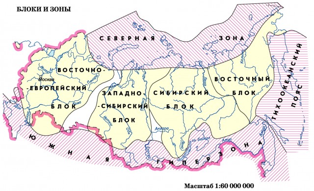
From the point of view of the structural-tectonic principle, a continent is called an isostatically balanced mass of the continental crust, which has a structural core in the form of an ancient platform, to which younger folded structures adjoin.
There are six continents on Earth: Eurasia, Africa, North America, South America, Antarctica and Australia. Each continent has one platform, and only at the basis of Eurasia there are six of them: Eastern European, Siberian, Chinese, Tarim (Western China, Taklamakan desert), Arabian and Hindustan. The Arabian and Hindustan platforms are parts of ancient Gondwana that joined Eurasia. Thus, Eurasia is a heterogeneous anomalous continent.
The boundaries between the continents are quite obvious. The border between North America and South America runs along the Panama Canal. The border between Eurasia and Africa is drawn along the Suez Canal. The Bering Strait separates Eurasia from North America.
Two rows of continents ... V modern geography the following two rows of continents stand out:
1. Equatorial continents (Africa, Australia and South America).
2. Northern row of continents (Eurasia and North America).
Outside of these ranks is Antarctica - the southernmost and coldest continent.
The modern arrangement of the continents reflects the long history of the development of the continental lithosphere.
The southern continents (Africa, South America, Australia and Antarctica) are parts ("fragments") of the single Paleozoic mega-continent of Gondwana. The northern continents at that time were united into another mega-continent - Laurasia. Between Laurasia and Gondwana in the Paleozoic and Mesozoic, there was a system of vast sea basins, called the Tethys Ocean. Ocean Tethys stretched from North Africa, across southern Europe, Caucasus, Western Asia, the Himalayas to Indochina and Indonesia. In the Neogene (about 20 million years ago), an alpine fold belt arose on the site of this geosyncline.
According to its large size, the supercontinent of Gondwana. According to the law of isostasy, it had a thick (up to 50 km) crust, which was deeply immersed in the mantle. Under them in the asthenosphere convection currents were especially intense pains, the softened substance of the mantle moved actively. This led first to the formation of a bulge in the middle of the continent, and then to its splitting into separate blocks, which, under the action of the same convection currents, began to move horizontally. As proved mathematically (L. Euler), the movement of the contour on the surface of the sphere is always accompanied by its rotation. Consequently, parts of Gondwana not only moved, but also deployed in geographic space.
The first split of Gondwana occurred on the border of the Triassic and Jurassic (about 190-195 million years ago); split off Afro-America. Then, on the Jurassic-Cretaceous border (about 135-140 million years ago), South America separated from Africa. At the border of the Mesozoic and Cenozoic (about 65-70 million years ago), the Hindustan block collided with Asia and Antarctica moved away from Australia. In the present geological era, the lithosphere, according to the neomobilists, is divided into six plate blocks that continue to move.
The collapse of Gondwana aptly explains the shape of the continents, their geological similarity, as well as the history of vegetation and fauna. southern continents.
The history of the split in Laurasia has not been studied as thoroughly as in Gondwana.
The concept of parts of the world ... In addition to the geologically determined division of land into continents, there is also the division of the earth's surface into separate parts of the world that has developed in the process of cultural and historical development of mankind. There are six parts of the world in total: Europe, Asia, Africa, America, Australia with Oceania, Antarctica. On one continent of Eurasia there are two parts of the world (Europe and Asia), and two continents of the western hemisphere (North America and South America) form one part of the world - America.
The border between Europe and Asia is very conditional and is drawn along the watershed line of the Ural ridge, the Ural River, the northern part of the Caspian Sea and the Kuma-Manych depression. In the Urals and the Caucasus, there are deep fault lines separating Europe from Asia.
Area of continents and oceans. Land area is calculated within the current coastline. The surface area of the globe is approximately 510.2 million km 2. About 361, 06 million km 2 is occupied by the World Ocean, which is approximately 70.8% of the total surface of the Earth. The land accounts for about 149, 02 million km 2, which is about 29, 2% of the surface of our planet.
The area of the modern continents characterized by the following values:
Eurasia - 53, 45 km 2, including Asia - 43, 45 million km 2, Europe - 10, 0 million km 2;
Africa - 30, 30 million km 2;
North America - 24, 25 million km 2;
South America - 18, 28 million km 2;
Antarctica - 13, 97 million km 2;
Australia - 7, 70 million km 2;
Australia with Oceania - 8, 89 km 2.
Modern oceans have area:
Pacific Ocean - 179, 68 million km 2;
Atlantic Ocean - 93, 36 million km 2;
Indian Ocean - 74, 92 million km 2;
Arctic Ocean - 13, 10 million km 2.
Between the northern and southern continents, in accordance with their different origins and development, there is a significant difference in the area and nature of the surface. The main geographical differences between the northern and southern continents boil down to the following:
1.It is incomparable in size with other continents of Eurasia, which concentrates more than 30% of the planet's land.
2.U northern continents significant in terms of shelf area. Especially significant is the shelf in the Arctic Ocean and Atlantic oceans, as well as in Yellow, Chinese and Bering seas Pacific Ocean. The southern continents, with the exception of Australia's submarine extension in the Arafura Sea, are almost devoid of a shelf.
3. Most of the southern continents fall on ancient platforms. In North America and Eurasia, ancient platforms occupy a smaller part of the total area, and most of them are in the territories formed by Paleozoic and Mesozoic mountain building. In Africa, 96% of its territory falls on platform areas and only 4% on mountains of Paleozoic and Mesozoic age. In Asia, only 27% falls on ancient platforms and 77% on mountains of various ages.
4. The coastline of the southern continents, formed mostly by split cracks, is relatively straight; peninsulas and mainland islands few. The northern continents are characterized by an exceptionally winding coastline, an abundance of islands, peninsulas, often far reaching into the ocean. Of the total area, islands and peninsulas account for about 39% in Europe, North America - 25%, Asia - 24%, Africa - 2.1%, South America - 1.1% and Australia (excluding Oceania) - 1.1% ...
According to modern concepts of geology, our planet consists of several layers - geospheres. They differ in physical properties, chemical composition, and In the center of the Earth is the core, followed by the mantle, then the hydrosphere and atmosphere.
In this article, we will consider the structure of the earth's crust, which is the upper part of the lithosphere. It is an outer hard shell whose thickness is so small (1.5%) that it can be compared with a thin film on the scale of the entire planet. However, despite this, it is the upper layer of the earth's crust that is of great interest to mankind as a source of minerals.
The crust of the earth is conventionally divided into three layers, each of which is remarkable in its own way.
- The upper layer is sedimentary. It reaches a thickness of 0 to 20 km. Sedimentary rocks are formed as a result of the deposition of substances on land, or their settling at the bottom of the hydrosphere. They are part of the earth's crust, located in it in alternating layers.
- The middle layer is granite. Its thickness can vary from 10 to 40 km. This is an igneous rock that has formed a solid layer as a result of eruptions and subsequent solidification of magma in the earth's thickness at high pressure and temperature.
- The lower layer, which is part of the structure of the earth's crust, is basaltic, also of magmatic origin. It contains more calcium, iron and magnesium, and its mass is greater than that of granite rock.
The structure of the earth's crust is not the same everywhere. The oceanic and continental crust are especially striking. Under the oceans, the earth's crust is thinner, and thicker under the continents. It has the greatest thickness in the regions of mountain ranges.
The oceanic crust consists of two layers - sedimentary and basaltic. Beneath the basalt layer is the Moho surface, followed by the upper mantle. The ocean floor has the most complex relief forms. Among all their diversity, a special place is occupied by the huge mid-ocean ridges, in which a young basaltic oceanic crust originates from the mantle. Magma has access to the surface through a deep rift - a rift that runs along the center of the ridge along the tops. Outside, magma spreads, thereby constantly pushing the walls of the gorge to the sides. This process is called spreading.
The structure of the earth's crust is more complex on the continents than under the oceans. The continental crust occupies a much smaller area than the oceanic - up to 40% of the earth's surface, but has a much greater thickness. Underneath it reaches a thickness of 60-70 km. The continental crust has a three-layer structure - a sedimentary layer, granite and basalt. In areas called shields, the granite layer is on the surface. As an example - made of granite rocks.
The underwater extreme part of the continent - the shelf, also has a continental structure of the earth's crust. It also includes the islands of Kalimantan, New Zealand, New Guinea, Sulawesi, Greenland, Madagascar, Sakhalin, etc. As well as inland and marginal seas: Mediterranean, Azov, Black.
It is possible to draw the border between the granite layer and the basalt layer only conditionally, since they have a similar seismic wave propagation speed, which determines the density of the earth's layers and their composition. The basalt layer is in contact with the Moho surface. The sedimentary layer can have different thicknesses, which depends on the relief form located on it. In the mountains, for example, it is either absent at all or has a very small thickness, due to the fact that loose particles move down the slopes under the influence of external forces. But on the other hand, it is very powerful in the foothill regions, depressions and hollows. So, in it reaches 22 km.
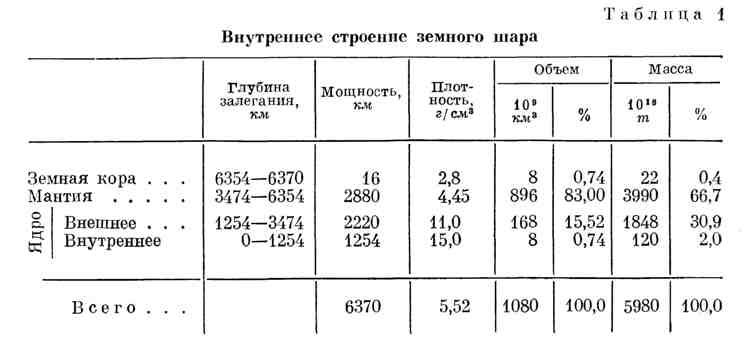
The shape of the earth is very little different from a sphere. It is only flattened along the axis of rotation by 42.8 km. Equatorial radius of the globe 6 378 245 m, polar - 6 356 863 m. The average radius of a sphere, equal to the size of the earth, is approximately equal to 6370 km. The volume of the Earth 1080 ∙ 10 24 cm 3, or 1080 ∙ 10 9 km 3; its mass is 5980 ∙ 10 24 g, or 5980 ∙ 10 18 T.
In the internal structure of the globe, on the basis of seismic studies, a clear division into crust, mantle and core is found. Each of these structural components is divided by less clear boundaries into a number of spheres.
The rocks that make up the Earth's mantle are not the same; from above they are less dense. The velocity of seismic longitudinal waves within the mantle increases with depth from 7.8 to 13.6 km / sec. At a depth of 2900 km it sharply decreases to 8.1 km / sec. Shear seismic waves only penetrate to the same depth. From a depth of 2900 km and to the center of the earth lies the substance that composes a core with a diameter of 6940 km. A spherical surface is also found inside the nucleus, which separates the so-called nucleolus, or inner core. Nucleolus diameter 2500-3000 km.
Based on the fact that shear waves do not pass into the core, it is considered that it is in a liquid state. In what form is the substance of the nucleolus - whether in the form of a liquid or in a solid state, it has not yet been possible to establish.
Based on the data obtained as a result of studying the Earth by seismic and other indirect methods, it can be assumed that the average density of the matter of the shells that compose the Earth, although not uniformly, increases with depth. Data on the depth of the boundaries separating the mantle from the earth's crust, the core from the mantle, and the nucleolus from the core, as well as the average values of the density of the rocks composing the shell, are given in Table. 1.
If the fractional participation of the shells of the globe in its volume can be judged with great certainty, then it is much more difficult to judge their mass, since there is no any reliable information about the density of matter and its chemical composition in the bowels of the Earth. The most objective data on the properties of matter in the bowels of the globe include only data on the rate of propagation
seismic waves. But the wave speed is influenced by a large number of factors, including density, porosity, chemical composition, strength, temperature, pressure, state of aggregation, etc. Therefore, there is no way to unambiguously solve the problem of the density of the substance that composes the shell of the Earth and its core.
The concept of "earth's crust" arose even when it was assumed that the earth was formed as a fiery-liquid body, on the surface of which, as a result of cooling, a thin crust of the most highly melting and lightest "slags" was formed.
It has now been proven that Earth is composed of solid matter, and the earth's crust is considered the layers that are
above the surface on which the speed of propagation of seismic waves increases by 1-2 km / sec. This surface was named after the Yugoslavian scientist A. Mohorovich who discovered it. It separates the earth's crust from the mantle - the next shell of the Earth, consisting of denser and more durable solid rocks.
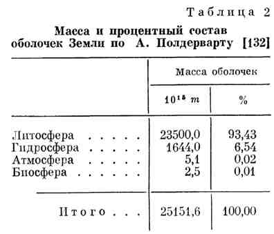
The Earth's crust, if this concept is understood as all types of matter located above the surface of Mohorovichich, consists of the lithosphere, hydrosphere, atmosphere and biosphere (Table 2).
There are two main types of the earth's crust: the crust of the continents and the crust of the oceans. They differ both in composition and in power. The thickness of the crust of the land, covering an area of 149 mln. km 2, on average 37 km, and the thickness of the oceans crust on an area of 361 mln. km 2 equal on average to only 7 km.
Both on land and under the oceans, the surface of the earth's crust is covered with sediments consisting of sandstones, clays and carbonate rocks. On the continents, their power is greater, in some places it reaches 20 km; at the bottom of the oceans, the thickness of precipitation is small and ranges from 0 to 3 km. A significant difference between the crust of the continents and the crust of the oceans is that there is a powerful (15-20 km) layer of granites. Below the granite shell, there is probably a layer of basalts of approximately the same thickness. The boundary between granites and basalts was named Conrad's surface. Under the oceans, the crust consists only of basalts, the thickness of the layer of which is on average about 5 km.
general characteristics physical layers of the crust according to the data of N. A. Belyaevsky and V. V. Fedynsky is given in table. 3.
Average density of the earth's crust 2.8 g / cm 3, subcrustal layer - 3.3 g / cm 3, the speed of the longitudinal waves 6 and 8 km / sec respectively. The crust is divided not only into continental and oceanic, but also has a large number of varieties. PN Kropotkin distinguishes 8 types of the earth's crust, differing in thickness and in gravity anomalies characteristic of each of them. The crust of the continents is usually characterized by high thickness and the presence of negative gravitational anomalies. Based on these characteristics, the following types are distinguished in it:
1) thick crust of folded ridges and raised areas and platforms (H = 50-80 km, Δ g from +550 to +200 mgl);
2) the crust of less elevated areas (H = 30-60 km, Δ g from -300 to +50 mgl);
3) crust of low plains and shelves (H= 15-40 km, Δ g from -100 to + 100 mgl)- subdivided into:
crust of stable Precambrian Epipaleozoic platforms with surface or shallow basement (H = 25-40 km); crust with a sharply reduced basement thickness.
In areas of the oceanic and suboceanic crust, P.N.Kropotkin identified 5 types:
1) the crust of the inland seas (H = 20-30 km, Δ g from -50 to +200 mgl) with a powerful complex of precipitation (10-15 km), lying on the "basalt" layer;
2) deep parts of the marginal seas (H = 7-25 km, Δ g from +150 to +450 mgl);
3) oceanic type of crust - continental slope, underwater ridges, volcanic islands (H =10-20 km, Δ g from +50 to +200 mgl);
4) bark of deep-sea trenches (H = 5-17 km, Δ g more than 250 mgl);
5) the crust of the deep parts of the World Ocean (H = 3-15 km, Δ g from +150 to +450 mgl).
A. Polderwart distinguishes two sharply different regions: the deep oceanic region, the area of which is 268 ∙ 10 6 km 2 with an average ocean depth of 4.5 km(the thickness of the bottom crust under this area is only 6 km), and an area of the continental shield with an area of 105 10 6 km 2 and an average height above sea level of 0.75 km. Continental crust thickness 35 km. He also distinguishes between two transition areas: the area of young folded belts, the area of which is 42 ∙ 10 6 km 2, with a crustal thickness of 14 km, and suboceanic (continental platforms and slopes, as well as marginal deep-sea ditches), with an area of 93 ∙ 10 6 km 2, with a crustal thickness of 18 km. Others 2 10 6 km 2 land is mainly found on volcanic islands located within the deep and sub-deep regions.
Of the total mass of the earth's crust by volume, the mainland accounts for 69%, or 5.5 ∙ 10 9 km 2, and the share of oceanic - 31%, or 2.5 ∙ 10 9 km 2.
It should be noted that the surface of Mokhorovichich lies at a certain depth characteristic of a given terrain, regardless of the age of the rocks that make up the earth's crust. So, for example, the surface of Mohorovichich passes at a depth of 40 km both in the Baltic Shield, where the rocks are of the most ancient age, reaching 3 billion years, and in young folded structures of the Caucasus.
Until recently, it was believed that the earth's crust, in contrast to the mantle, is composed of rocks in which the velocity of longitudinal seismic waves corresponds to the velocity in granites and basalts. However, the work carried out mainly during the IGY revealed cases when the Mohorovichich surface passes in the region of seismic wave velocities exceeding 6-7 km / sec. Such speeds cannot take place in granite and basalt. And now it is not clear what the earth's crust is, because the density of the rocks lying above the surface of Mohorovichich is sometimes characteristic of the rocks of the upper layers of the mantle, and not of the crust. The earth's crust of the land differs sharply from the crust of the ocean in chemical and mineral composition. Both are even more different from the material of the mantle both in density and strength, and in chemical composition, however, information on the composition of the material of the mantle is very limited.
Many hypotheses have been put forward about the nature and origin of the earth's crust, none of which gives a satisfactory explanation of the reasons for the difference in the composition and thickness of the crust of land and oceans.
T. Wilson suggested that the earth's crust, like the hydrosphere and atmosphere, was formed from the material of the mantle due to volcanic eruptions ejecting fusible substances melted in the depths of the mantle (T. Wilson takes the surface of Mohorovichich as the initial surface of the Earth). As a result of these volcanic eruptions, the former surface of the Earth remained deep under a layer of igneous rocks.
This assumption is unacceptable, not only because (as follows from the data he cites) the arrival of volcanic matter in recent centuries is only about 0.8 Km 3 per year, and the river drift of matter from the continents per year exceeds 12 km 3, but also because it does not explain the differences in the crust of continents and oceans.
To explain the reasons for the appearance of the continental and oceanic crust, as well as continents and oceans, hypotheses were proposed that attract various cosmic factors.
G. Alfvén in 1963 put forward a hypothesis explaining the formation of continents by the fact that 3-4 billion years ago the Moon, supposedly an independent planet, came so close to the Earth that it collapsed, part of it fell to the Earth and formed the continental crust, unevenly covering the surface of the Earth: the other part became our satellite - the Moon, and small particles - meteorites.
J. Darwin in 1911 put forward a hypothesis according to which the Pacific Ocean bed was formed as a result of the detachment of a part of the earth's surface, which turned into our satellite - the Moon. This idea still finds numerous followers (O. Openheim, R. Schwiner, G. Quiring, G. I. Berlin, E. Kraus, etc.).
Some scientists believe that the Earth is cooling and contracting, while others, on the contrary, find evidence of the rapid expansion of the globe. There are also attempts to explain the observed phenomena and facts by specific processes, the course of which is possible either in the earth's crust or in the rocks of the Earth's mantle. Thus, V.V.Belousov develops a radiomigration hypothesis, according to which the formation of continents, the enrichment of continental strata with silicon, tectonic and volcanic processes are associated with the differentiation of the material of the Earth's mantle and with the release of rocks rich in radioactive substances from it. Such rocks, close in composition to granites, in his opinion, float to the surface of the earth's crust and cause uplift, melting and other processes that require thermal and mechanical energy. Repeated analogous phenomena in the same places, according to VV Belousov, are associated with the fact that differentiation takes place in different "levels" of the mantle not once, but sequentially.
In recent years, VV Belousov came to the conclusion that the Earth's surface first passed the stage of granitization, when "In the Archean the entire globe was more or less uniformly covered with continental crust, which later only increased in thickness." Then, at the end of the Paleozoic, in his opinion, a turning point occurred, when an ultrabasic material rose into the crust, melting the continental crust and submerging back into the mantle; as a result, "... in place of the continental crust, an oceanic type crust was formed." The process of further oceanization of the land crust, he believes, will continue in the future.
This hypothesis, like others based on the processes of differentiation of the mantle material, is unsuitable for explaining the long existence of continents and oceans. In addition, this hypothesis is in irreconcilable contradiction with the laws of physics and mechanics, according to which a less dense substance cannot plunge into a denser one. Therefore, the ultrabasic matter that floated to the surface of the Earth after the dissolution of thick strata of the continental crust in it could not go into the mantle, as V.V.Belousov admits.
VA Magnitskiy put forward the idea of the formation of continental strata and their enrichment with silicon. According to him, silicon is released from the mantle rocks as a result of the reaction
For thermodynamic reasons, this reaction should proceed in layers of the mantle located at a depth of no more than 500 km. At greater depths, it is more stable MgSiO 3 ... This idea may help to understand the enrichment of continental rocks with silicon, but it does not explain why the continental strata rise above the ocean floor by almost 5 km. Highlighting SiO 2 within the upper mantle, the volume of rocks should have decreased as much as the volume of the earth's crust increased. The total effect of the process of differentiation of products according to the above reaction cannot significantly affect the level of the day surface. The same total effect is inevitable in the implementation of serpentinization processes. In these processes he sees the solution to the riddle of the emergence of continents. X. X... Hess, who for 25 years has been developing the idea of an increase in the rocks of the Earth's mantle when they turn into the earth's crust due to the addition of water to olivines with the formation of serpentines having a composition corresponding to the formulas:
At the same time, the density of the rocks decreases and they supposedly float on the heavier rocks of the mantle. It is true in this view that the density of rocks decreases due to the addition of water. However, the water that joined the rocks of the upper mantle had to come out of the deeper horizons of the mantle, where, as a result, a corresponding increase in the density of the remaining matter and a decrease in its volume would occur. The net effect of this movement of water from bottom to top is zero.
There are also more radical points of view on the reasons for the appearance of boundaries found in seismic studies of the Earth. Thus, A.F. Kapustinsky believes that they are associated with changes in the structure of the outer electron shells of atoms, which occur under the influence of pressure. Outer electrons at pressures existing at the depth of the Mohorovichich surface supposedly move to unfilled energy levels, and the electron shells acquire a denser packing. By analogous transformations in the structure of the electron shells, he explains the increase in the density of the substance of the Earth's core and its transition to the "metallic state".
However, since the lower boundary of the earth's crust is located at a relatively shallow depth, especially under the oceans, and, moreover, at very different depths, the explanation associated with changes in the structure of atoms under the influence of pressure cannot be applied to justify the appearance of the Mohorovicic boundary.
D. Kennedy paid much attention to the analysis of the problem of the origin of the earth's crust and the creation of a hypothesis that should lead the science of the earth's crust out of the dead end. He believes that the following facts contradict the concept of the sialic crust of the oceans and the sialic composition of the crust of continents floating on a denser simatic substrate.
1. Large areas of continents eroded to sea level can suddenly be lifted thousands of feet upward.
2. The laws of physics are violated by the fact that sediments with low density, apparently, are able to displace rocks more high density; troughs of low-density sediments are likely to sink into a more dense substrate.
3. The rate of heat transfer from the bowels of the Earth through continents, mountain ranges and oceanic basins, in the first approximation, is the same.
4. The lifespan of continents and mountain ranges is much longer than could be expected from the rate of erosion.
D. Kennedy sees the answer to the difficult problems associated with the formation of light crustal rocks that make up the continents in the fact that the Mohorovichich boundary is not a division between rocks of different chemical composition, but between rocks of the same composition, but of different mineral composition and crystalline structure. ... D. Kennedy, like a number of his predecessors, believes that below the basalts and gabbros lie eclogites, which are close to them in chemical composition. Since eclogites have a density of 3.3 g / cm 3, i.e. 10% higher than the density of gabbro (2.95 g / cm 2), then eclogites can exist only at high pressures. In these structural transitions of basalts into eclogites, D. Kennedy sees a clue to the nature and origin of the Mohorovichi section. He claims to have experimentally discovered (at 500 ° C and pressures below 10,000 atm) the transition of basalt glass to gabbro, the main component of which is feldspar. At pressures above 10,000 atm and 500 ° C, basalt glass crystallizes into a rock consisting of jadeite pyroxene, and eclogites are formed. Depending on pressure and temperature, light rocks can transform into dense ones and vice versa. Accordingly, there is an increase or decrease in the thickness of the layer of rocks located above the transition surface.
According to D. Kennedy, this hypothesis explains well not only the same heat flow in the rocks of the continents and oceans, but also the long existence of continents, the thickness of the crust of which is constantly increasing due to a decrease in the density of the floating mantle rocks.
D. Kennedy sees the reason for the increase in the thickness of the crust in the fact that the lower horizons of the continental crust allegedly heat up and thus shift to higher pressures the conditions for the transformation of dense mantle rocks into less dense crustal rocks, i.e., they shift the Mokhorovichich boundary downward.
According to D. Kennedy, there are completely different conditions at the border of Mohorovichich. Under the oceans, the transformation of gabbro into eclogite occurs at a depth of 6-7 km at a temperature of about 150 ° С, under the continents - at a depth of 30 km at a temperature of 500 ° С, and under mountain ranges - at a depth of 40 km and more at a temperature of 700 ° C and above.
These interesting arguments of D. Kennedy seem to be justified in terms of criticism of existing hypotheses about the earth's crust. They reveal the really weak points of science about the origin of the earth's crust, continents, mountain ranges and oceanic trenches. They correctly pose the questions, the solution of which is necessary for a hypothesis that claims to be recognized. He more sharply than usual emphasizes the problem of long-term existence of continents, which, according to his calculations, at the existing rate of erosion of land masses should be completely eroded in 20-25 million years. True, he also underestimates the intensity of erosion. In fact, given the current demolition rate of 12 Km 3 solid matter per year, the continents should be washed away not in 20-25 million years, but only in 10 million years.
However, the possibility of phase transformations of solid rocks near the Mohorovichich boundary, i.e., near the boundary lying at a shallow depth, especially under the oceans, has not yet been proven. Thus, as a result of an experimental study of the phase state of rock matter at pressures up to 35 kbar and at temperatures up to 1700 ° C, carried out at the Institute of Physics of the Earth in 1964, the absence of decomposition of pyroxene into olivine and stipoverite was established under conditions corresponding to depths from 10 to 100 km... This proved that the emergence of the Mohorovichich boundary cannot be explained by such a process.
The refusal to recognize the difference in the chemical composition of the earth's crust and mantle, in addition, is in clear contradiction with reality. The study of the chemical composition of the rocks of the crust of the oceans and the crust of continents has convincingly shown that they have a significant difference in composition and physical properties.
The chemical composition of the earth's crust also differs from the average composition of meteorites, and there is no reason to expect that the chemical composition of the mantle can be the same as the composition of the earth's crust.
In recent years, A.P. Vinogradov has been developing the problem of the formation of the earth's crust in terms of its material composition. By calculations and experimentally, he substantiates the idea that the earth's crust is a product of melting and degassing of mantle material in processes similar to zone melting.
The zone melting method was developed by J. Pfann for the purification of semiconductor materials, mainly germanium and silicon. It consists in the fact that one end of the metal rod is heated with a high-frequency current or other local heater until melting, and then the heater is moved along the rod or rod through the heater from the heated end to the cold end. In this case, the molten zone moves to the cold end of the rod and transfers all low-melting components there. In this case, the most refractory components move towards the movement of the zone and gradually concentrate at the initial end of the rod. With a sufficient number of passes of the molten zone along the rod, the metal is freed from easy and refractory impurities and can be obtained in an extremely pure form.
The use of this method made it possible for A.P. Vinogradov to show that as a result of multiple displacement of the molten zone along the rod of the material of the silicate phase of chondrites, it occurs through its separation into two parts. Basalt glass forms as a low-melting component, and the remnant becomes very similar to dunites, which are known to belong to olivine rocks composing the upper mantle layer.
A.P. Vinogradov believes that the process of zonal melting of low-melting basalt magma with its release to the Earth's surface not only creates the earth's crust, but also “... is responsible for the formation of continents, mountain structures, subsidence and rise of platforms, for the formation of geosynclines and the ocean - all the deepest geological transformations ”. However, he does not express considerations about those specific processes by which "... degassing and melting of low-melting, basaltic magma" cause the appearance of continents and oceans and carry out "all the most profound geological transformations." He only believes that the effect of the products of melting and degassing of the mantle substance should be completely different depending on “... why they are released. If they stand out under layers of sedimentary or other rocks, then their profound change occurs - granitization. If the selection is under the layer ocean water, then they collapse and dissolve, and if they enter the atmosphere, they enrich it with gases and other substances. "
These considerations do not explain how granitization occurs if the low-melting part enters under the layers of sedimentary rocks. Moreover, this does not make it clear the question of where did these sedimentary rocks come from before they received the products of melting. Therefore, questions about the origin of the earth's crust, about the origin of continents and oceans, as well as questions of "geological transformations", remain even after a series of interesting works by A. P. Vinogradov, as before, are still far from clear. It became clearer that the earth's crust, the hydrosphere, and the atmosphere can be formed from a substance similar to the substance of meteorites, but how and as a result of what processes the separation of the initial matter of the earth's crust into its varieties - land crust and ocean crust - remains unclear.
Based on data on the content of volatile components in the mantle material, as well as in the hydrosphere and atmosphere, A.P. Vinogradov determined the degree of melting and degassing of the mantle material, which occurred during the existence of the Earth, i.e., in 4.7-5 ∙ 10 9 years. It turned out to be less than 10%. Thus, the degree of nitrogen evolution is ~ 5%; carbon ~ 2.5%, sulfur ~ 5 ∙ 10 -3%, helium -0.1%, argon 40 ~ 2 ∙ 10 -2%. The highest percentage of degassing for such volatile components as H 2 O and C1 2 was about 7.5% of their content in the mantle material. This fraction of its mass by volume is equal to 63 ∙ 10 9 km 3. If we assume that degassing has occurred in the layers of the upper mantle, then this will correspond to a layer with a thickness of only 125 km.
For a number of elements, an increased content in the earth's crust is observed in comparison with their content in the substance of meteorites. Considering that they were removed from the material of the mantle, AP Vinogradov determined its thickness, which is necessary for the removal of an excess amount of a number of elements, so that their content in the earth's crust becomes what is observed in reality (Table 4).
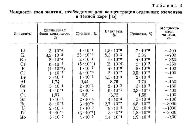
As you can see from the table. 4, the required design thickness of the mantle is different and ranges from 100 to 3000 km. It is possible that given in table. 4, the calculations will be refined over time, but they convincingly indicate that the release of most of the elements occurred only from a relatively small part of the material that composes the Earth's mantle. But for uranium, thorium, rubidium, potassium and especially barium, the thickness of the degassed mantle reaches a very large value, reaching one third or even half of the Earth's radius.
The different degree of enrichment of the earth's crustal rocks with one element or another in comparison with its content in the mantle material or, as A.P. Vinogradov does, in comparison with its content in the meteorite matter can be explained not only by their removal from mantle layers with different thicknesses , but also by the difference in distribution coefficients. The distribution coefficient of different compounds is certainly not the same, and therefore their removal into the earth's crust with a molten layer rising upward should be different. The lower the distribution coefficient, that is, the less a given compound precipitates into the solid phase, the more it is carried out with the melt during zone melting.
Therefore, it is more acceptable to explain the different degree of enrichment of the earth's crust with elements removed from the Earth's interior by the difference in distribution coefficients than by the difference in the thickness of the mantle layers from which one or another component of the earth's crust is removed.
Considering the formation of the earth's crust in the process of zonal melting, A.P. Vinogradov suggested that the thickness of the earth's crust, like the thickness of the crust of any other planet, is determined by the radius of the planet. Of course, the radius of the planet, as a quantity that determines the volume of the planet, also determines the amount of heat released as a result of radioactive decay under a unit of the planet's surface. The amount of heat, in turn, determines the thickness of the molten zone, which rises upward from the bowels of the Earth in the process of zone melting. This, of course, determines the thickness of the upper layer that will be most enriched in the most mobile components carried out in the melt. However, this is only true for the case when there is only one pass of the molten zone or when both the number of passes and the thickness of the molten zones were exactly the same for the compared planets.
The greatest influence on the thickness of the earth's crust in the case of its formation as a result of zone melting can have the number of passes of the molten zone. The more passes, the higher should be the concentration and the degree of removal of those components that accumulate in the earth's crust (if it really forms as a result of zonal melting).
Therefore, there is no reason to expect the dependence of the thickness of the earth's crust only on the radius of the planet. Under the conditions of the Earth, the thickness of the crust varies over a very wide range - from 5-7 to 25-40 km.
The thickness of the earth's crust is especially great under mountainous areas, where it reaches 70 and even 80 km.
The thickness of the earth's crust is in a strictly regular connection only with its external relief - the higher the land area, the more powerful the crust, and the deeper the ocean, the thinner it is. This pattern does not depend on the age of the crust, despite intense erosion. It is also important that each variety and each thickness of the crust corresponds to a strictly defined layered structure - the structure of a "puff pie", each layer of which has its own thickness and its own chemical and mineral composition, the formation of which required the mobilization of radioactive and other elements from the depths of the mantle hundreds of depths and even thousands of kilometers.
Therefore, hypotheses that deserve attention can be considered only those (of the many proposed) that can explain: a) the regular relationship of the thickness and composition of the crust with the relief of the land surface and ocean floor; b) the preservation of this natural connection throughout the existence of the continents, despite denudation; c) a sharp difference in the composition of the crust from the composition of the mantle in the content of radioactive and many other elements, which are concentrated mainly in the earth's crust.
The processes of simple high-temperature differentiation of the mantle material, as well as the processes of release of water, silicon oxide or "basaltic" magma during zone melting, cannot be considered sufficient. They do not explain the differences between the crust of continents and the crust of the oceans and, what is even more important, they cannot explain the facts of the mutual transformation of the crust of one type into the crust of another type. These transformations, called oceanization and continentization, are increasingly being confirmed. Without an explanation of the processes by which the crust of the continents sometimes turns into the crust of the ocean floor, it is impossible to understand numerous facts, for example, the facts of an abnormally thin crust observed in the Hungarian middle massif, in the Gulf of Mexico, in the Okhotsk, Black, Caspian Seas and in some areas Central Asia, since the data of geological history and comparative analysis do not allow us to doubt that earlier in these areas there was a normal, that is, sufficiently thick, continental crust.
In addition to the Mokhorovichich surface, numerous seismic boundaries, waveguides, shells and layers with high electrical conductivity were found in the earth's crust, upper mantle and below. All of them differ, on the one hand, in that the speed of propagation of seismic waves changes abruptly on them, and, on the other, in that they form, as it were, concentric spheres, dividing the earth into layers and shells with almost the same thickness.
The appearance of layers of increased conductivity - waveguides - is determined by the fact that the velocity of wave propagation in them is lower than in the higher and lower layers of rocks. Therefore, the waves do not go up and down from such a layer, but move in it with full internal reflection from the roof and soil of the layer. Most often, when waveguides appear, they see an increase in temperature, which leads to a decrease in the density of a substance. The decrease in the density of rocks is also explained by the rearrangement of the mineralogical or molecular structure of the rocks that make up the waveguides. However, since waveguides have been found at very different depths both in the earth's crust and in the mantle, it is difficult to assume any specific phase transformations of solids, the flow of which is possible in such wide ranges of temperatures and pressures.
As you know, there is no single point of view either on the reasons for the appearance or on the nature of the stratification of the earth's crust and the Earth as a whole.
The following processes are considered as the reasons for the occurrence of layering in the earth's crust:
layering of sediments and suspensions falling out of the water at the bottom of reservoirs, especially during the advance and retreat of the sea;
layering of suspended matter falling from the atmosphere, including the fallout of volcanic ash precipitation;
layering of some rocks over others as a result of landslides, thrusts, etc.
True, more and more supporters of the point of view appear that seismic boundaries are special boundaries, the origin of which does not depend on the composition, origin and age of the rocks in which they pass.
So, G.D. Afanasyev, noting that the Mokhorovichich boundary passes at a certain depth characteristic of a given terrain, regardless of the age of the rocks composing the earth's crust, suggests drilling deep wells in the Ukrainian crystalline massif and the Baltic Shield, where at a depth of 6 - 7 km the interfaces of seismic waves were found. The study of these wells, in his opinion, “... will make it possible to understand how steeply set folded formations of metamorphic rocks are, as it were, stratified in horizontal plane, forming layers with a thickness of about 5 km from different speed of propagation of seismic waves. Is there a vertical change in the petrographic composition of these "layers" or only a change in their physical properties, in particular density, in connection with an increase in the ever-increasing load of the underlying rocks?
Yu. V. Riznichenko and IP Kosminskaya believe, “... that deep seismic boundaries and, accordingly, layers are a consequence of the influence of both the composition and state of matter under conditions of pressure, temperature and movement of matter in the bowels of the Earth. They represent some fronts of metamorphism characteristic of certain rather narrow depth intervals, at least in stable platform conditions. These boundaries have a significantly different nature than the stratigraphic boundaries familiar to geologists, or, on the other hand, boundaries of a disjunctive nature between different-type complexes of metamorphic and other rocks or between magmatic massifs of different composition and formation time ...boundaries should be recognized as secondary and superimposed on the primary geological structural features of the environment ”.
AA Borisov draws attention to the fact that “The seismic boundaries identified within the consolidated (crystalline) complex of the earth's crust (Konrad's boundary, etc.) are characterized by very gentle morphological forms, approximately parallel to each other and to the surfaces of the basement and Mohorovichich. This contradicts geological, gravimetric, magnetic and other data that the folded, often deeply metamorphosed, complexes of the consolidated crust are characterized by sharp and complex, mainly block, structural forms. This author makes an attempt to reveal the specific reasons that, acting in time, lead to the fact that a definite connection between the morphology of the surface of Mohorovich and the relief of the earth's surface is observed everywhere. He writes: “Apparently, surface morphology is due to the interaction of two opposing factors:
1) the direct direction of vertical movements of this segment of the lithosphere, which leads to the formation of approximately concordant forms in all horizons of the crust and surface of Mohorovichich, and
2) processing of the material of the earth's crust and upper mantle with its corresponding redistribution between them, which is accompanied by the formation of reversed forms.
Depending on the predominance of this or that factor, the ratio of morphological forms in different horizons of the lithosphere is determined. "
Of course, these two opposite factors, especially the second, are still very general and not specific. As a result of what processes and under the influence of what reasons the "processing" of the material of the earth's crust and the upper mantle occurs, AA Borisov cannot say, but the substantiation of the need for such "processing" encourages researchers to search in new directions.
V.V. Tikhomirov paid special attention to a very important and specific feature of the Mokhorovichich surface - its dynamism. Analyzing the problem of the origin of granites, he cites a large number of examples confirming the point of view of many geologists that sedimentary rocks under the influence of various metamorphosing factors are transformed into massive crystalline formations such as granites. On the other hand, the point of view about the processes called "basification" or oceanization, as a result of which the substance of the continental crust is converted into the substance of the ocean crust, is gaining more and more recognition. Taking this into account, V. V. Tikhomirov writes: “It can be assumed that as the sialic block sinks, its lower portions turn into peridotite rock and join the underlying formations, while the Mokhorovichich surface seems to jump to a higher stratigraphic level, being in the same time at the same absolute depth. Figuratively speaking, the rocks of the submerging part of the earth's crust, when lowering below the isohypse corresponding to the horizon of the Mohorovichich surface at a given point of the planet, turn from "sial" into "sima" and, separating from the upper shell, adhere to the peridotite substrate. "
The surface of Mohorovichich, being a special surface, is at the same time one of many other seismic boundaries found both in the earth's crust, in the mantle and in the core.
The thickness of the layer, the top of which is represented by the modern relief, and the bottom - by the "crust-mantle" boundary, most often referred to as the "Mokhorovichich surface", varies widely within Russia and adjacent water areas - from 12 to 60 km The layer has a complex mosaic structure, however there are clear regional patterns. Globally, the central region is distinguished, consisting of four large superblocks of an isometric shape: East European, West Siberian, Siberian and East. In tectonic terms, these superblocks correspond to the East European and Siberian ancient platforms, the West Siberian young plate separating them and the Verkhoyansk-Chukotka fold region occupying the northeastern part of Russia. On the south, the superblock system is framed by a wide latitudinal-oriented hyperzone stretching from to. From the north, the superblocks of the continental part are limited by a powerful strip of latitudinal strike, covering the coast of the Arctic seas and seas. It corresponds to the northern shelf zone of the Eurasian continent. In the east is the Pacific belt.
The superblocks of the continental part of Russia have the following characteristics. The smallest average crustal thickness corresponds to the West Siberian superblock (36–38 km). In the East European superblock located to the west of it, the average thickness increases to 40–42 km, while the Siberian superblock is distinguished by the thickest crust (43–45 km on average). In the eastern superblock, where the position of the Mohorovichich boundary is determined from very scarce data and using gravimetric information, the thickness of the earth's crust is approximately 40–42 km.
Superblocks are separated by contrasting linear structures or wide zones of sharp changes in the thickness of the earth's crust. Thus, the East European superblock is separated from the West Siberian by a narrow extended meridional zone with anomalously high thickness (45–55 km), corresponding to the Ural fold system. The eastern boundary of the West Siberian superblock is a meridional system of close short linear structures of different signs against the background of a relatively wide zone of a sharp increase in thickness. It corresponds to a powerful system of troughs and uplifts that separates the Siberian and West Siberian platforms. The border separating the Siberian superblock from the Vostochny one is a long, knee-like bending zone along the Lena and Aldan rivers. It is traced by a chain of linear and ellipsoidal lenses of reduced power (up to 36 km). Tectonically, interblock zones are folded systems and orogenic belts of the Phanerozoic.
The southern hyperzone is a system of contiguous and en-echelon linear and ellipsoidal structures of latitudinal and close directions. The zone is distinguished by a differentiated structure and sharp contrasting changes in the thickness of the earth's crust from 36 to 56 km
The northern shelf zone, while retaining many structural features of adjacent superblocks of the continental crust, is distinguished by a significant reduction in thickness to 28–40 km. The structure of the shelf zone of the western Arctic sector differs from the eastern one both in geometric parameters and in the thickness of the earth's crust. The northern boundary of the Russian shelf area with blocks of thin oceanic crust (10–20 km) is the “continent-ocean junction zone” 50–70 km wide, which is a zone of sharp difference in thickness.
The earth's crust within the Pacific belt is distinguished by a complex morphology and large differences in crustal thickness from 12 to 38 km. The general regional pattern is a sharp decrease in the thickness of the earth's crust when moving from continent to ocean. Relatively thick crust (26–32 km) is characteristic of the plates in the waters of the Okhotsk and. Geosynclinal systems are characterized by similar values of this parameter, while they have a very heterogeneous internal structure. The values of the thickness of the earth's crust of the middle level (24–26 km) are inherent in the island arc (Kuril), the thinnest crust is characterized by the structures of the oceanic crust - deep-sea depressions (10–18 km).
As a result, it can be stated that the thickness of the earth's crust as a whole correlates with the age of the structures: the thickest crust (40–45 km) is observed under the cold ancient platforms - the East European and Siberian; under the West Siberian, its thickness is less (35–40 km). Under the folded systems and orogenic belts of the Phanerozoic, the thickness of the crust varies widely (38–56 km), being, on average, more thick than the crust of the platforms. Under the young mountain structures of the Altai-Sayan region, there are "roots" of mountains deeper than 54 km