More than 2.5 million rivers flow through the territory of Russia. The overwhelming majority of them (94.9%) are 25 km or less in length. The number of medium rivers, 101 to 500 km long, is 2833 (0.1%), the number of large rivers is 214 (0.008%).
Russian rivers belong to the basins of three oceans: the Arctic, Pacific and Atlantic. In addition, some of the rivers flow into internal, not connected with, seas and lakes.
More than half of the territory of Russia (65%) belongs to the basin and its marginal seas (White, Kara, East Siberian and Chukotka). The main, central part of this basin is occupied by the main arteries of the country - the Ob, Yenisei and Lena rivers, between which the basins of the Taz, Pur, Pyasina, Khatanga and others are located. The basins of the Pechora, Northern Dvina and Onega, to the east - the basins of the Yana, Indigirka, Kolyma, etc.
The origin of the name today is unknown. All this was originally in the hands of foreigners. Russian colonization began from the upper stream, where the Slavs drove out various Finnish breeds. A large stream of Bolgar blossomed in the middle stream. The invasion of the Tatars, who were subjected to the older settlers, stopped the Russians for almost three centuries. Only after the conquest of Kazan and Astrakhan, and after the destruction of the local estate Tatar Russian element, does it progress further along the central and southern Volga.
It also allowed the scene of various storms that in their time rocked the Russian kingdoms. An important role that V. did not always play in the history of Russia, and especially in the economic life of the Russian people, aroused people gave her attention, she sings many songs and call him Mother and "Breadwinner". Brockhaus and Jeffron Dictionary. Semenov, where is the literature. In ancient times it was called Rha, and in the Middle Ages Itil. Currently, this longest river in Europe is called the Volga.
The pool The Pacific owns about 19% of the territory of Russia. River runoff enters the marginal seas of the Pacific Ocean - Okhotsk and Japanese. The Anadyr rivers flow in the northern part of the basin and the Amur, in the southern part. Rivers in the mid-Pacific Basin are short streams with small basin areas.
The basin includes about 5% of the area of Russia, this includes the river network belonging to the basins of the Baltic, Black and. The largest rivers of the Baltic basin are the Neva, Narva, Western Dvina, Neman; basin - the Dnieper river; basin - the Don and Kuban rivers.
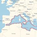
Rivers and cities associated with the Volga
The huge potential of the Volga was exploited for centuries by both the tsar and the people. This made it possible to move from one part of the country to another, both to people and to raw materials. However, the longest river in Europe has a glorious historical fact because there were camps in her pool, i.e. labor camps, where political enemies were sent not only from Russia, but also from Poland.
Published in Physical Geography. Rivers are a small part of the hydrosphere. However, the water they contain is, however, the most loaded element. River Research Research - Potamology. A river is water that flows in a constant deflection due to gravity. During the year, the river depletes 30 times more water than it currently does. River water exchange takes place every 11 days.
The area of the Caspian closed drainage area is 11% of the territory of Russia. It includes such large rivers as the Volga, Ural, Terek.
The watershed between the basins of the Arctic and Pacific oceans runs along the Chukotka ridge, Anadyr plateau, mountain ranges: Kolymsky, Dzhugdzhur, Stanovoy and Yablonovy. The watershed of the closed-flow Caspian basin is formed by the Sayan and Altai mountain systems, and Atlantic Ocean-, Northern Ridges and Maanselkä Upland.
All waterways can start from swamps, lakes, springs, glaciers. Surfaces on the surface can also be enriched with water coming directly from precipitation or from groundwater. The amount of flowing water usually increases with distance from the outflow point, as the individual waterways connect to each other to form a river system. Thus, the river system forms the main river together with its tributaries. River systems vary with land size, surface shape, geology and climate.
The size of river systems and their location is determined by the shape of the surface, geological structure and climate. The largest river system forms the Amazon River due to its location in the humid climatic zone and the formation of a river basin area of about 7 km 2, mainly in a low-lying geological trough. It also creates the largest delta in the world and an area of over 100,000. km 2. The width of the river near the estuary is almost 15 km. The Amazon, which enters the Atlantic Ocean, drains its waters 400 km offshore.
The watershed between the Atlantic Ocean basin and the basin runs along the Valdai, Central Russian, Volga and Stavropol Uplands, along the Main Caucasian Ridge.
Rivers are unevenly distributed on the territory of Russia. In the desert areas of the Caspian region, in some places there are no rivers at all, and in the mountains of the Caucasus, mountain systems Altai and Eastern Siberia there are a lot of them.
The peculiarity of the structure of the river network in Russia lies in the predominantly meridional direction of the flow of most of the large rivers. Average density of the river network Russian Federation, which is an indicator of the watering of the territory, is equal to 0.49 km per 1 km2.
The Amazon is also the main communication route in its areas of existence. The image of the Nile system is completely different. The Nile, taking over the East African Highlands in a climate of climate, flows through areas of different climates. It will also carry 100 times less water than the Amazon.
Inland waterways are associated with river systems that include areas called basins or catchments. The area from which water flows into one main river. Each river basin and catchment area shares a boundary as a watershed. Its border usually runs along the largest hills surrounding the river basin.
Most of the rivers carry their waters to the Arctic (64%) and (27%). In the Azov-Black Sea (1%) and Caspian basins (7%), there are only 193,942 rivers. The basin accounts for less than 2% of the total number of rivers in Russia.
Five largest rivers Russia has an area exceeding 1000 thousand km2. First of all, this is the Ob River, which collects water from a vast basin with an area of 2990 thousand km2. The catchment areas of the Yenisei, Lena and Amur rivers are respectively 2580, 2490 and 1855 thousand km2. The Volga, the first largest river in Europe, occupies only the fifth place among Russian rivers in terms of basin area (1360 thousand km2).
A bifurcation is a fork in a river for two or more arms, which then flow into two different river basins. It is relative a rare event, which we encounter in rivers with a soft current flowing through the plains, often also swampy. An example of a bifurcation can be the Polish river Obra, flowing near Mosina. At this point, part of its waters are given to the neighboring Warta. A similar connection exists between the Upper Danube and the Rhine. A large scale bifurcation is the upper part of the Orinoco River, where some waters flow from the Rio Negro to the Amazon.
The largest in length is the Ob River (with the Irtysh), the length of which, if (the Irtysh River is taken as its source), is 5570 km. The Lena, Yenisei and Amur rivers are over 4000 km long.
The rivers Volga, Kolyma, Ural and Olenek are over 2000 km long.
In terms of water content, the Yenisei takes the first place among the rivers of Russia with an average annual water discharge of 19870 m3 / s and an average long-term annual flow of 630 km3.
Often the bifurcation is caused by the kite, which means that one river is catching another. This process occurs most often when one of the rivers, due to the greater fall, is more vigorously cut to the ground. A stretch of water and river water intersect and flow into the river. As a result, the river depletes the river basin at the expense of parts of the second river basin.
The basins of all rivers flowing into one sea or ocean form the catchment area of the river. Main catchment the globe is the watershed of the Atlantic Ocean, which accounts for 46% of the land area. The catchment area belongs to most of the main rivers on our planet. 33% of the land area is located in the catchment area of the Indian and Pacific Ocean. The remaining 21% belong to the so-called. areas without drainage, that is, areas from which surface waters do not flow out into the sea, but die on the road or end their course in a waterless lake or swamp.
The Ob, which has the largest catchment area, is inferior in water content not only to the Yenisei, but also to the Lena: the average annual water discharge of the Lena River is 16300 m3 / s, and the Ob - 12600 m3 / s. The relatively low specific water content of the Ob River is explained by the fact that in the southern part of its basin there are vast inner drainage areas and territories with low surface runoff.
The largest non-basin areas include the Volga basin and other rivers flowing into the Caspian Sea, the Turin Plain with waters into Lake Aral, the Central Asian Kashmir basin, the Chad basin and Okavango in Africa, the large artesian basin in Australia, and other smaller ones.
Depending on the amount of precipitation and their changes during the year, one can distinguish between permanent rivers in which water flows unhindered through the river bed. Rivers of this type are found in humid climate where precipitation is higher than evaporation. Rivers can be fed by runoff with rainwater, melting water, melting snow or glaciers, lakes and groundwater. As the river outflow outstrips the power, the rivers disappear before reaching the mouth.
Among the world's largest rivers in terms of flow, the Yenisei, Lena, Ob, Amur and Volga occupy the fifth, seventh, twelfth, fourteenth and fifteenth places, respectively.
Currently, on the territory of Russia, there are about 60 large (with a flow rate of more than 100 m3 / s) earthen canals, laid in various geological and climatic conditions. Many of them are complex channels. Extensive experience has been accumulated in the construction and design of canals in the south of Russia, in the Urals, in Western Siberia... The largest canals in Russia are: Volgo-Caspian, White Sea-Baltic, im. Moscow, land, Bolshoi Stavropol, Tersko-Kumsky, Nevinnomyssky.
On the territory of Russia, there are more than 2.7 million lakes with a total water surface area of 408 856 km2. Among them, only 19 lakes have a surface area exceeding 1000 km2. The total area of the surface of these lakes is 108,065 km2.
In the tropics, there are periodic rivers that only carry water for a certain period of time, such as during the rainy season. An example of this type of river would be, for example, Murray in Australia. Surface flows dominate seasonal rivers. They also come through small groundwater... In extremely dry climates, we are dealing with episodic rivers that arise only after heavy rains.
These rivers flow in gutters where there is no water for a long time. Water in episodic rivers is found irregularly, even every few years. These rivers are mainly found in deserts. These valleys are characterized by steep slopes and flat bottoms. They are filled with rubble and sand. Examples of ephemeral river valleys are Wadi Saura in Algeria or Wadi Khuvar in Sudan.
Most of the lakes (98%) are small (surface area less than 1 km2) and shallow (depth 1–1.5 m). Almost all lake water reserves are concentrated in several large reservoirs. Thus, the volume of 23 thousand km3 is 5 times higher than the total annual flow of all rivers in Russia.
On the territory of Russia, the lakes are distributed extremely unevenly. In some areas they are quite rare, but in others they occupy a significant part of the surface - sometimes up to 10-50% of the total area of the area. There are ten lake regions within Russia.
These rivers are fed only by the surface. In addition to climatic conditions topography, geological construction and vegetation play an important role in the flow of rivers. These factors affect the size of surface runoff as well as underground supplies. The more intense the surface flow, the greater the slope of the terrain and the less permeable the substrate. The rivers flowing into the main river are its tributaries. The main factors affecting the water level in the river are.
Power supply, vaporization. ... The geopolitical division of Europe is completely different. Europe has one inland continental sea in the north and three intercontinental seas in the south. Interregional areas connecting the seas of Europe with Baltic Sea in the west, define the key triple cities of Europe in the western, central and eastern parts.
In addition to numerous small and medium-sized lakes, there are such large ones as Ladoga, Onezhskoe, Beloe, Chudskoe, Pskovskoe, Vygozero, Segozero, Kovdozero, Pyaozero, Imandra. Most lakes have glacial origin... Tectonic lakes are also widespread. This type includes many lakes and. In places of shallow bedding of easily soluble rocks, there are karst lakes. The Azov-Black Sea region is characterized by a large group of peculiar lakes located along the coast. Their origin is associated with the activity of the sea, mainly they are estuaries (Yeisk, Beysug, etc.). Most of the lakes in the Caspian region, covering the Caspian lowland, are fed by the flooding of steppe rivers during spring floods. Temporary water bodies are typical, but there are also large lakes - Elton, Baskunchak, Chelkar, Sarpinskie lakes, etc. In the West Siberian region, which includes the steppe and forest-steppe zones of the West Siberian lowland, there are tens of thousands of lakes. As a rule, they are small and represent flat saucer-shaped depressions of suffusion origin. Lakes Altai region They are developed mainly in the crimson basins, they are distinguished by their rounded outlines and small size. The largest of them are Marka-Kul. Most of the lakes of the Trans-Baikal region are remnants of the disappeared larger bodies of water - Zun-Torey, Barun-Torey, etc. Kesey, etc.). The Yakutsk lake district is located on the territory of the Leno-Vilyui lowland and the Lena-Amginek watershed. There are several tens of thousands of small lakes of thermokarst origin here. The subpolar sea region includes the tundra zone of the Arctic Ocean coastline abounding in lakes. The origin of the lakes is predominantly thermokarst. Most of the lakes of the Kamchatka region are volcanic and are located in craters and calderas extinct volcanoes... Despite their small size, they differ in significant depths. The largest of the lakes are Kurilskoye and Kronotskoye. There are lakes of a different origin - lagoon type (for example, Lake Nerpichye at the mouth of the Kamchatka River).
The main link between the Baltic Sea and Mediterranean Sea passes through the German and French lowlands and through the former amber routes. Western Europe stretches geopolitically from the Vistula to the Iberian Peninsula. The main link between the Baltic Sea and the Caspian Sea is along the longest river in Europe - the Volga, where the basin is located in Moscow. Russia is the only state in Eastern Europe, that is, the Baltic-Caspian miracle.
Central Europe is the Miocene region of the Balkan-Black Sea region. The main arteries connecting Black Sea with the Black Sea, there are three large pairs of rivers: the western part of the Odra-Danube, the middle part of the Vistula-Dniester and the eastern Dyvin-Dnieper. Therefore, the main Central European borders are defined by the Odra, Danube and Dnieper basins.
VOLGA, a river in the European part of Russia, the largest in Europe. The length is 3530 km (before the construction of the reservoirs, 3690 km), the basin area is 1360 thousand km 2 (it occupies 65% of the territory of the European part and 8% of the entire territory of Russia).
The Volga basin belongs to the drainless basin of the Caspian Sea and is entirely located within the East European Plain. It stretches from the Valdai and Central Russian Uplands in the west to the Urals in the east for almost 2.3 thousand km.
This is the minimum geopolitical range Central Europe in which every part of the world overlaps. The alternative triplet was three different medians, including ocean waters: Mediterranean-Atlantic, Black Sea-Baltic, Caspian Barents. While in the first version, the western part of Poland belongs at the same time to Western Europe and Central Europe, in the second version, Central Europe includes the entire Baltic Sea basin, which also includes the East German states.
Slavic legend as a geopolitical parable
In any case, the central core of Central Europe is the Balkan Black Belt. In the biggest battle European era Bronze, from Thessaly, genetic research has created three genetic types: South European, North European, and Central European. Since legends are not fairy tales, but some parodies of reality, and in the legend of the founding Slavic society of the three brothers Lech, Bohemia and Russia, one can see a reflection of this very natural division of the Slavic language, whose Black Sea Cradle is divided into three main arteries - sub-regions: Oder- Danube, Visya-Dniester, Dyvina-Dnieper.
The Volga originates from the Valdai Upland. In the past, various rivers were considered its source: Runa, Kud, Zhukopa, flowing into the Volga in the upper reaches. At the end of the 19th century, the expedition of D.N. Anuchin established that the Volga flows out of a spring near the village of Volgoverkhovye (Tver region) at an altitude of 228 m (a wooden frame with a terrace was built above the well with a key).
These three states flourish in "nests", which are links with trade routes, so the gnome is located in a connection between the western and central arteries of our interstellar river and the same main river artery of Batytka with the North Sea, that is, west coast Europe.
It is also very easy to find the "nest" of Russia: Smolesk, which was formerly called Gnezdovo, or "nest". Smolevsk is a city on the Dnieper, and Gniezno, built on seven hills. Its name comes from the dam of the river after their intersection between the Duvina, which is part of the Baltic Sea, and the Dnieper, which is part of the Black Sea. Thus, Smolevsk was a city that was one of the classic roles Black Sea-Miocene federation a thousand years ago.
It is customary to divide the Volga into 3 parts: the Upper Volga - from the source to the mouth of the Oka River, the Middle Volga - from the mouth of the Oka to the mouth of the Kama River and the Lower Volga - from the mouth of the Kama to the Caspian Sea. During the first kilometers of its course, the Volga is a stream winding through a wooded and swampy area. In the upper reaches, within the Valdai Upland, the Volga flows through the small lakes Verkhit, Sterzh, Vselug, Peno and Volgo.
A dam (Verkhnevolzhsky beishlot) was built at the source from Lake Volgo in 1843 to regulate the flow of water and maintain navigable depths during low water periods. The only conditionally natural section of the Volga with a length of about 400 km ends near the city of Tver. Below, to the very mouth, the river is completely transformed by hydraulic structures (the largest were built in 1950-60) and is a cascade of hydroelectric power plants with reservoirs. Ivankovskoe (the so-called Moscow Sea), Uglichskoe and Rybinskoe reservoirs were created between Tver and Rybinsk. On the Rybinsk - Yaroslavl section and below the city of Kostroma, the river flows in a narrow valley among high banks crossing the Danilovskaya and Galichskaya Uplands. Further flows along the Unzha and Balakhna lowlands. Near the town of Gorodets (above the town of Nizhny Novgorod), the Gorky Reservoir was formed. The main tributaries of the Upper Volga: Tverda, Medveditsa, Mologa, Suda, Kostroma and Unzha (left).
In the middle reaches, the Volga becomes more full-flowing. It flows along the northern edge of the Volga Upland. The Cheboksary reservoir is located above Cheboksary. The largest tributaries of the Middle Volga are Oka, Sura, Sviyaga (right) and Vetluga (left).
In the lower reaches, after the confluence of the Kama (left tributary), the Volga becomes a mighty river. Above the city of Togliatti, the Kuibyshev reservoir was formed. Further, the Volga goes around the Zhiguli mountains, forming an arched bend Samarskaya Luka. Above the town of Balakovo there is the Saratov reservoir. The Lower Volga receives relatively small tributaries - Samara, Bolshoi Irgiz, Eruslan (left) and Tereshka (right). 21 km above the city of Volgograd, the left branch is separated from the Volga - the Akhtuba River, which flows parallel to the main channel. The vast space between the Volga and Akhtuba, up to 40 km wide, crossed by numerous channels and old rivers, forms the Volga-Akhtuba floodplain. The Lower Volga runoff is regulated by the Volgograd hydroelectric complex.
Flowing into the Caspian Sea, the Volga forms a vast delta. The mouth of the river lies 26 m below sea level. The delta begins at the point where the Buzan branch separates from its channel (46 km north of Astrakhan) and is one of the largest in Russia (19 thousand km 2). There are up to 500 branches, channels and small rivers in the delta. The main branches are Bakhtemir (navigable), Kamyzyak, Old Volga, Bolda, Buzan, Akhtuba. Below the source of Buzan, a water divider was built to redistribute the flood flow between the eastern and western parts delta, this provides annual flooding (even in dry years) in its eastern part of the spawning grounds of semi-anadromous fish.
![]()
Hydrological regime. River system the Volga basin includes more than 150 thousand watercourses over 10 km long with a total length of 574 thousand km. 2600 rivers flow directly into the Volga and its reservoirs. The left tributaries are more numerous and more watery than the right ones. Most of the tributaries are located in the upper and middle parts of the river, below the mouth of the Kama they are small, shallow, many of them dry up in summer. Most of the tributaries are typically flat rivers with wide, well-developed valleys and the asymmetry of slopes characteristic of the Northern Hemisphere. The Volga basin is located in the southern part of the forest zone, in the forest-steppe, steppe and semi-desert zones. Most of the basin (72% together with the foothill part of the Urals) is located in the forest zone, where 87% of the runoff is formed. Snow food (60% annual flow), ground (30%) and rain (10%).
By the nature of the water regime, the Volga belongs to the Eastern European type with a pronounced spring flood, summer-autumn low water, disturbed by rain floods, and a stable winter low water. In natural conditions, 55-66% of the annual runoff took place in spring, 24-32% in summer and autumn, and 10-13% in winter. The cascade of hydroelectric complexes on the Volga and its tributaries has a great regulating effect on the water and level regime of the river, the runoff has significantly (1.5-2 times) decreased during the flood period and the runoff increased during low-water periods, especially in winter.
65% of the annual runoff of the Volga is formed in the Kama basin, the Middle Volga basin accounts for 22%, the Upper - 13% of the runoff. Average annual water discharge (m 3 / s): at the Verkhnevolzhsky beishlot 30, at Tver 180, at Yaroslavl 1010, at Nizhny Novgorod 2970, at Samara 7300, at Volgograd 7500. Below Volgograd, the river loses about 5% of its runoff for evaporation. During periods when the annual runoff was close to natural, the Volga annually brought about 250 km 3 of water to the Caspian Sea. The range of runoff fluctuations for the period of instrumental observations (since 1881) was 240 km 3. So, in 1926 more than 390 km 3 of water passed along the Volga, and in 1937 - 150 km 3. The longest period of low water was observed in 1933-40. The average annual runoff for this period was 185 km 3, which is 25% below the norm. A long period of low water was observed in the late 1970s. From 1978 to the end of the 20th century, there was a period of increased water content on the Volga. In 1978-95, the runoff increased by an average of 30% compared to the previous dry period and by about 5% compared to the norm. The distribution of the mean long-term runoff layer over the territory of the Volga basin is generally zonal. It varies from 250 mm in the northern part to values close to zero in the south. This distribution of the runoff layer is disturbed in the regions of the Middle and South Urals, where its value is usually higher than the zonal values.
 The Volga freezes in the upper and middle reaches at the end of November, in the lower - at the beginning of December. It breaks open in the upper reaches in early April, in the lower reaches in mid-March, and throughout the rest of the course in mid-April. The river remains free of ice for about 200 days, near Astrakhan - about 250 days. With the creation of reservoirs, the ice regime of the Volga has changed: in the upper reaches the duration of ice phenomena has increased, in the lower ones there are ice-free openings almost every year, which have different lengths depending on the temperature and release regimes.
The average annual flow of suspended sediment near Volgograd is 23 million tons. The delta receives an average of 12.5 million tons of sediment, 87% of which occurs in the spring, 11% - during low-water periods and 2% - in winter. The average annual turbidity of water in the delta branches is 50-60 g / m 3, the maximum is 100-160 g / m 3 (observed in April - May). As a result of regulation, the solid runoff on the Volga decreased by more than three times. The waters of most of the rivers in the Volga basin belong to the hydrocarbonate class. The salinity and hardness of the water increases from the forest zone to the semi-desert.
Resources and their economic use. The Volga is inhabited by about 70 species of fish, 40 of them are of commercial importance, including the most valuable sturgeon, as well as roach, bream, pike perch, carp, herring. The decline in the number of some fish species in last years associated with the deterioration of the ecological situation, as well as with a change in the hydrological and hydrobiological regimes, deterioration of the conditions for fish spawning and feeding of juveniles. Earlier in the Volga basin, more than half of fish catches in inland water bodies of Russia and over 90% of sturgeon were caught. Over the past decades, the productivity of the fishery has decreased several times. A catastrophic situation has been created with sturgeon stocks, which is due to poaching throughout the entire Caspian Sea, as well as insufficient work on artificial reproduction, protection and conservation of sturgeon numbers in feeding and spawning grounds.
The total volume of the Volga-Kama cascade of reservoirs is 168 km 3, useful - 80 km 3. Almost all reservoirs are of a flat type with large flooded areas. During their construction, more than 20 thousand km 2 of highly productive floodplain lands were taken out of use. All HPPs of the Volga cascade produce about 40 billion kWh of electricity per year. 37 constituent entities of the Russian Federation are fully or partially located within the Volga basin. This is the most densely populated region of Russia, with a population of about 60 million people. One third of all industrial and agricultural products of Russia are produced in the Volga basin, which determines a high degree of anthropogenic pressure.
Water withdrawal from natural water bodies of the basin at the end of the 20th century was approximately 26.5 km 3 / year (10% of the annual flow of the Volga and 30% of the total water withdrawal in Russia). In the 1990s, the volume of water use in the basin decreased by more than 30%, which is associated with a decline in industrial and agricultural production. The largest amount of water (57%) is used for production needs, 29% - for public utilities, 14% - for agricultural needs. Water consumption is unevenly distributed throughout the basin: the maximum values are in the Moscow, Nizhny Novgorod, Samara, Astrakhan regions and the Perm Territory; the minimum water consumption is observed in industrially less developed areas of the northern part of the basin (Perm Territory and Kirov region) and in the Republic of Mari El.
The discharge of waste and return waters amounted to about 17.5 km 3 / year, of which almost half is polluted waste water. As a result of anthropogenic impact, the waters of large and significant parts of small rivers in the Volga basin are polluted. Wastewater is the main source of pollution. industrial enterprises, municipal and agricultural waste water. The main pollutants are petroleum products, copper compounds, easily oxidized organic substances. A comprehensive assessment of the degree of pollution of the Volga at the end of the 20th century indicates that the quality of the river's water changed from “polluted” to “dirty”, and the tributaries - from “polluted” to “extremely dirty”.
The Volga is connected to the Baltic Sea by the Volga-Baltic waterway, to the White Sea by the Severo-Dvinskaya water system and the White Sea-Baltic Canal, with the Azov and Black Seas by the Volga-Don Canal, with the Moskva River by the Moscow Canal. Regular shipping is carried out from the city of Rzhev (over 3200 km). Popular tourist routes pass along the Volga. In the river basin there are Astrakhan, Volzhsko-Kamsky, Zhigulevsky, Prioksko-Terrasny reserves, National parks Meshchersky, Samarskaya Luka and other protected natural areas... The largest industrial centers and ports on the Volga are Tver, Rybinsk, Yaroslavl, Kostroma, Nizhny Novgorod, Cheboksary, Kazan, Ulyanovsk, Togliatti, Samara, Saratov, Volgograd, Astrakhan.
I. S. Zaitseva.
Historical sketch. The first mentions of the Volga are found in the works of the ancient Greek historian Herodotus (5th century BC). In the works of ancient authors of the first centuries of our era (Ptolemy and Marcellinus), the Volga is called Ra (‘pα,“ generous ”). In written Byzantine and Arabic sources, along with this name, Itil was used, or Ethel ("river of rivers", " great river"). In the "Tale of Bygone Years" it is referred to as the Volga (from the Old Russian "vologa" - liquid, water, or from the Finno-Ugric "valga" - "bright river"). Geographical position Volga and its large tributaries caused its transformation into the largest waterway, determined the most important political and commercial importance. In the Volga basin, there were large state formations - the Khazar Kaganate, Bulgaria Volzhsk-Kama. In the 9-10th centuries, the cities of Itil, Bolgar and others played a significant role in the Volga trade, in the 10th - 1st third of the 13th century - Russian cities (Novgorod, Rostov, Suzdal, Murom). The Mongol-Tatar invasion temporarily interrupted contacts along the Volga, except for the Upper Volga basin, where the Novgorod Republic, the Yaroslavl principality existed, as well as the Vladimir Grand Duchy, from which the Tver principality emerged in the middle of the 13th century. At the end of the 13th century, the Gorodets principality was formed on the Middle Volga. A significant part of the territories in the middle reaches, as well as territories in the lower reaches of the Volga, fell under the rule of the Golden Horde, here its largest centers arose (Sarai, Sarai Novy). In the 14th century, the Nizhny Novgorod principality was formed on the Middle Volga. In the 15th century, the Kazan Khanate and the Astrakhan Khanate, which were annexed to the Russian state in 1552 and 1556, became the heirs of the disintegrated Golden Horde. As a result, the entire Volga basin was included in it. This revived Russian trade with the countries of the East. In the 16-17 centuries, new cities arose - Samara, Saratov, Tsaritsyn (now Volgograd) and others. In the 17-18 centuries, the Volga basin became the main scene of the insurgents during the Razin uprising of 1670-71 and the Pugachev uprising of 1773-75. At the beginning of the 19th century, the Volga basin was connected by the Mariinsky water system with the Neva river basin, which led to the revival of merchant shipping. Large shipments of bread, salt, fish, oil and cotton, timber, metals, etc. were carried out along the Volga. Passenger traffic along the Volga was one of the most developed in Russia, especially before the construction railways... In the 1st half - the middle of the 19th century, the labor of barge haulers was actively used. In 1820, the first steamship appeared on the Volga; from the middle of the 19th century, steamship traffic was widely developed. The largest shipping companies on the Volga were Along the Volga (founded in 1843), Airplane (1853), and Caucasus and Mercury (1858; founded in 1849 as Mercury). Large industrial centers became the cities of Yaroslavl, Nizhny Novgorod, Samara, and others located on the Volga. Civil War In 1917-22, the Volga had an important military-strategic importance, the Volga military flotilla (1918-19), the Astrakhan-Caspian military flotilla (1918-19), the Volga-Caspian military flotilla (1919-20) of the RKKF were based and operated here. Since the 1930s, the construction of hydroelectric power plants began on the Volga (the first, Ivankovskaya, was built by 1937). On the banks of the Volga, one of the key battles of the Great Patriotic War took place - the Battle of Stalingrad 1942-43.
Lit .: Zaitseva I.S. Low-water years in the Volga basin: natural and anthropogenic factors. M., 1990; Water of Russia. Yekaterinburg, 2000. [T. 3]: River basins; Anthropogenic Impacts on Water Resources in Russia and Neighboring States at the End of the 20th Century. M., 2003; Natural resource, environmental and socio-economic problems environment in large river basins / Otv. editor V. M. Kotlyakov. M., 2005.