Stages of the formation of the political map of the world
The process of forming the political map of the world goes back several millennia. Many historical eras have passed, so we can talk about the existence of periods in the formation of the political map of the world. There are ancient, medieval, new and modern periods.
The ancient period (from the era of the emergence of the first forms of the state to VB. AD) covers the era of the slave system. It is characterized by the development and collapse of the first states on Earth: Ancient Egypt, Carthage, Ancient Greece, Ancient Rome, etc. These states have made a great contribution to the development of world civilization. Even then, military action was the main means of territorial change.
The medieval period (V-XV centuries) is associated in our minds with the era of feudalism. The political functions of the feudal state were already more complex and diversified than those of states under a slave system. The internal market was formed, the isolation of the regions was overcome. The desire of states for distant territorial conquests, for the search for new (sea) routes to India, was manifested, since the overland trade routes to the East (after the fall of Constantinople) were under the control of the Ottoman Empire.
During this period, there were states: Byzantium, the Holy Roman Empire, England, Spain, Portugal, Kievan Rus, etc. The political map of the world changed greatly during the era of the Great geographical discoveries.
Chronology:
1420s - the first colonial conquests of Portugal: Madeira, Azores, Slave Coast (Africa). 1453 - the fall of Constantinople.
1492-1502 - the discovery of America (4 travels of Columbus to Central America and the northern part of South America). The beginning of the Spanish colonization of America.
1494 - Treaty of Tordesillas - division of the world between Portugal and Spain.
1498 - the voyage of Vasco da Gama (the route from Europe around Africa to India).
1499-1504 - travels of Amerigo Vespucci to South America.
1519-1522 - trip around the world Magellan and his companions.
It was from the turn of the XV-XVI centuries. a new period of history began (which lasted until the First World War at the beginning of the 20th century).
This was the era of the birth, rise and consolidation of capitalist relations in the world. She laid the foundation for the European
colonial expansion and the spread of international economic ties throughout the world.
In the era of the great geographical discoveries: Spain and Portugal were the colonial powers. But with the development of "manufactory production, England, France, the Netherlands, Germany, and later the USA came to the forefront of history. This period of history was characterized by large colonial conquests. The world was redrawn many times.
The political map of the world became especially unstable at the turn of the 19th and 20th centuries, when the struggle for the territorial division of the world sharply intensified between the leading countries. So, in 1876, only 10% of the territory of Africa belonged to Western European countries, while in 1900 - already 90%. And by the beginning of the XX century. in fact, the division of the world turned out to be completely completed, that is, only its violent redistribution became possible.
The beginning of the Newest period in the formation of the political map of the world is associated with the end of the First World War (the first stage). The next milestones were the Second World War, as well as the turn of the 1980s and 90s, which is characterized by major changes on the political map of Eastern Europe(collapse of the USSR, Yugoslavia, etc.).
The first stage was marked by the appearance on the world map of the first socialist state (RSFSR, and later the USSR) and notable territorial changes on the political map, and not only in Europe.
Austria-Hungary collapsed, the borders of many states changed, new sovereign countries were formed: Poland, Finland, the Kingdom of Serbs, Croats and Slovenes, Austria, Hungary, etc. The Ottoman Empire was divided. The colonial possessions of Great Britain, France, Belgium, Japan expanded (due to the territories transferred to them under the control of the League of Nations mandate - former colonies Germany and the territories of the Ottoman Empire). -?
The second stage (after World War II), in addition to territorial changes on the political map of Europe, is associated primarily with the collapse of the world colonial system and the formation of a large number of independent states in Asia, Africa, Oceania, Latin America.
Since the beginning of the 90s. highlight the third stage Newest history which continues to this day. To qualitatively new changes on the political map of the world, which had a great impact on the socio-economic and socio-political life of the entire world community during this period, include the following:
The collapse of the USSR in 1991; declaration of political sovereignty, first of the three former union republics (Baltic), and then of the rest of the republics the former USSR, including Russia;
Formation of the Commonwealth of Independent States (CIS);
Implementation of predominantly peaceful ("velvet") people's democratic revolutions of 1989-90. in the countries of Eastern Europe (former socialist countries);
Union Arab states YAR and NDRY (May 1990) on a national-ethnic basis and the formation of the Republic of Yemen with the capital in Sana'a;
... - ^ the termination in 1991 of the activities of the Warsaw Pact Organization (OVD) and the Council for Mutual Economic Assistance (CMEA), which seriously affected the political and economic situation not only in Europe, but throughout the world.
The disintegration of the SFRY, the proclamation of the political independence of the republics of Slovenia, Bosnia and Herzegovina, Macedonia, Croatia, Union Republic Yugoslavia (as part of Serbia and Montenegro). The most acute political crisis former federation turned into civil war and ethnic conflicts;
Continuation of the process of decolonization: Namibia gained independence - the last of the colonies in Africa; new sovereign states were formed in Oceania: the Federated States of Micronesia, the Republic of the Marshall Islands, the Commonwealth of the Northern Mariana Islands (former "wards" of the US territory);
Formation of two independent states - Czech Republic and Slovakia (disintegration of Czechoslovakia on January 1, 1993);
The proclamation of the independence of the state of Eritrea (formerly a province of Ethiopia on the shores of the Red Sea and fought for self-determination for about 30 years) - 1993
The scale of future changes on the political map of the world will be determined by the further course of ethnocultural processes in multinational countries, the nature of economic, political and cultural relations between countries and peoples.
Territory and borders>
Geographic concept"Territory" is specific, binding to certain coordinates the earth's surface... Hence, it is possible to define that the territory is a part of the land surface with its inherent natural resources and properties created as a result of human activity. The spatial factor plays a definite and very noticeable role in the life of society.
State boundaries define the boundaries of the state territory. The entire inhabited part of the land and the vast sea areas adjacent to it are divided between state formations, and therefore, there are state borders everywhere on it. In addition, there are other boundaries between
states that do not have state status. These should include the borders under international agreements, temporary State border - these are lines and imaginary vertical surfaces passing along these lines, defining the boundaries of the territory of the state (land, water, subsoil, air space), that is, the limits of the spread of sovereignty. The state border is a political and economic border "limited by the state system, national isolation, customs control, rules of foreign trade, etc. Land and sea state borders between, with -" border states are established by agreement. There are two types of state borders - delimitation and demarcation.
Delimitation is the definition by agreement between the governments of neighboring states of the general direction of origin of the state border and drawing it on geographic map... Demarcation - drawing a line of the state border on the ground and marking it with the appropriate border signs -
State borders are known, drawn along natural (natural) boundaries, taking into account the terrain (orographic boundaries), drawn along a straight line connecting two points of the border (geometric boundaries) defined on the ground and, finally, passing through certain geographical coordinates and sometimes coinciding with one or another parallel or meridian (geographical boundaries).
The last two types of borders are widespread in Africa and America. There are all types of borders in Russia.
On border lakes, the state border line runs in the middle of the lake or in a straight line connecting the outlets of the land state border to its shores. Within the state territory, the boundaries of administrative-territorial units (republics, states, provinces, lands, regions, etc.) and economic regions are also distinguished.
Allocate state territory, as well as territories with international and mixed regimes.
A state territory is a territory under the sovereignty of a certain state. The territory of the state includes: land within borders, waters (internal and territorial) and airspace over land and waters. Most of the coastal states (there are about 100 of them) have territorial waters (a strip of coastal sea waters) a width of 3 to 12 nautical miles from the coast.
Territories with an international regime include land areas lying outside the state territory, which are in the common use of all states in accordance with international law. It's an open sea, airy pro
the voyage above it and the deep seabed beyond the continental shelf.
The international legal regime of the Arctic regions of the high seas (the Arctic Ocean) has some peculiarities. Canada, Russia and other countries have divided it into "polar sectors". All lands and islands within the "polar sectors", ice fields near the coast are part of state territories these countries. The "Polar Sector" is a space whose base is the northern border of the state, the top is the North Pole, and the lateral borders are the meridians.
It should also be noted the special international legal regime established in Antarctica under the 1959 treaty. The mainland is completely demilitarized and open for scientific research of all countries.
Outer space is outside the earth's territory and its legal regime is determined by the principles and norms of international space law.
The territories with a mixed regime include the continental shelf and the economic zone.
The definition of belonging, regime and boundaries adjacent to the coast of relatively shallow areas of the World Ocean developed in the second half of the XX century. into an important political and legal problem in connection with the possibility of exploration and development of natural resources of the continental shelf (oil, gas and other minerals). According to some estimates, the area of the continental shelf is almost 1/2 of the surface of the World Ocean.
In accordance with the 1982 UN Convention on the Law of the Sea, the continental shelf means the seabed and subsoil of underwater areas extending beyond the territorial waters of a state along the entire length of the natural continuation of its land territory to the outer border of the continental margin or at a distance of 200 nautical miles from the initial lines from which the width of the territorial waters is measured, when the outer boundary of the underwater edge of the continent does not extend such a distance.
The outer boundary of the continental shelf cannot be further than 100 nautical miles from the 200-meter isobath (line of equal depths) and must not extend beyond 350 nautical miles from the baselines from which the breadth of territorial waters is measured.
The depths of the shelf edge are usually 100-200 m, but in some cases reach 1500-2000 m (South Kuril Basin of the Sea of Okhotsk).
The countries of the world have the exclusive right to explore and exploit "their shelf", but do not have sovereign rights to the corresponding water area.
The establishment of economic zones was initiated in the late 1960s. Latin American states. By the mid-1980s. their example was followed almost in “other states of the world, including our country. Economic zones now account for 40% of the world's oceans, including areas that provide 96% of the world's fish catch.
Economic zones are areas of the world's oceans outside the territorial waters about 200 nautical miles wide, in which the coastal state exercises sovereign rights to exploration and development mineral resources, scientific research, fishing (zones of national jurisdiction over resources), while other countries enjoy freedom of navigation and have access to surplus allowable catch (under the UN Convention on the Law of the Sea).
And our country was allocated a site in the central, equatorial part of the Pacific Ocean (with an area of about 75 thousand kmC for prospecting and exploration work on the ocean floor.
Fishing zones and shelves often exceed the area of the state's land territory and can significantly increase its resource potential.
Special territorial regimes are international legal regimes that determine the legal status and procedure for the use of any limited territory or space. They can be established in the interests of some or all states of the world.
Thus, the modes of navigation on international rivers, straits and canals used for international navigation are known; regimes for fishing and other types of marine fishing; exploitation of mineral resources of the seabed (exploitation of the continental shelf, etc.); regime of water use and other types of economic activity on border rivers, etc.
Special types of territorial regime are the international legal lease of territory, the regime of “free economic zones”, privileged in the customs relation, etc. (The regimes for the use of military bases in foreign territories do not belong to the category of a special territorial regime).
The main objects of the political map of the world
On the political map of the world, the main objects are various state formations: sovereign states and non-self-governing (politically dependent) territories. The system of state formations is changeable and contradictory. Knowledge of its features, the dynamics of modern development is important for understanding all the socio-political and economic processes taking place in the modern world. It is the system of states of the world that is studied by such a science as geopolitics, which reveals the relationship between socio-economic and geographic features states.
Let's start with sovereign states. Throughout the XX century. their number has steadily increased. So, in 1900 at the globe there were only 55 of them. At the same time, there were huge colonial empires of Great Britain and France, and such countries as Japan, the Netherlands, Belgium, Portugal, Italy, Spain, and the USA had colonies. While maintaining these possessions, the growth of the number of independent countries could not be rapid. By 1940, their number had increased to 71. The collapse of the colonial system after World War II, the rapid growth of national liberation movements radically changed the political map of the world. In 1947 there were already 81 sovereign countries, in 1959 - 92, and now there are about 190 of them. any foreign power (except in cases of explicit and voluntary consent to the limitation of its sovereignty).
It is no coincidence, when speaking about the number of independent countries on the modern political map, we did not give an exact figure, but said about 190. The fact is that the political status of a number of state entities is currently not defined. This applies, for example, to the state of Korea, which during the war was divided by a demarcation line into northern and southern parts. This was a temporary ceasefire line. Subsequently, the states were created: the DPRK and the Republic of Korea. But it is still not the state border that separates them, but the demarcation line. Therefore, strictly legally, there are not two Koreas, but one. In fact, Taiwan, which exists as a state, is in fact a province of China. The state of East Timor, marked on all maps, has long ceased to exist, since it was forcibly annexed to Indonesia. This list could be continued.
In addition, there are territorially clearly defined state formations with an undefined political status. In the former Spanish colony of Western Sahara, after a long civil war, a truce was established. A referendum on self-determination (independence or integration with Morocco) is to be held here.
There are currently about 300 objects in the world on which there are disputes: territorial, border, ethnic; including more than 100 of those where there is an acute conflict situation. Thus, the dispute between Spain and Great Britain on sovereignty over Gibraltar is not over. The dispute between Great Britain and Argentina over the Falkland Islands (Malvinas) led to an armed conflict between these states in 1982. Since 1947, the issue of the borders of the State of Israel and the creation of a Palestinian state have not been resolved. The list of examples of this kind can be continued.
This is the struggle of the Kurdish people for self-determination and the formation of the state of Kurdistan; border conflicts between India and Pakistan (especially in the states of Jyimu and Kashmir); conflicts on the territory of the republics of the former SFRY (Yugoslavia), in Northern Ireland (Ulster); on the territory of the republics North Caucasus(Russia); in African states, etc.
There are currently about 40 non-self-governing (politically dependent) territories. There are several forms of political dependence.
The traditional, classical form of a dependent territory is a colony. Colony (from Latin - colonia - settlement) is a country or territory under the rule of a foreign state (metropolis), deprived of political and economic independence and governed by a special regime. There are 22 colonies in total. All of them are included in a special UN list, as the world community believes that they should gradually be granted independence. The largest country with colonies is still Great Britain. Let's list her colonies.
1. Gibraltar (disputed territory with Spain).
2. St. Helena Island (Atlantic Ocean).
3. Antilla (Caribbean Sea).
4. Virgin Islands (Caribbean Sea).
5. Cayman Islands (Caribbean Sea).
6. Montserrat (Caribbean Sea).
7. Terke and Caicos (Caribbean).
8. Pitcairn (Oceania).
9. Bermuda (Atlantic Ocean).
10. Falkland Islands (Malvinas) Islands (disputed territory of Great Britain and Argentina).
Colonies of the Netherlands ".
1. Antilles(Bonaire, Curacao, Saba and others).
2. Aruba (Caribbean). Colonies of the USA:
1. Virgin Islands (Caribbean).
2. Eastern Samoa - "unincorporated" territory (Oceania).
3. Guam (Pacific Ocean, in the Mariana Islands group).
4. Islands in Oceania (including uninhabited ones) where military bases are located: Johnston, Sand, Palmyra, Jarvis, Kingman Reef, Howland, Baker.
5. Midway (an atoll in the central Pacific Ocean).
6. Wake - an atoll consisting of three islands: Wake, Wilsa, Peel (in the central part of the Pacific Ocean).
Australia (Norfolk Island in Oceania) and New Zealand (Tokelau Islands - Non-Self-Governing Territory of New Zealand) each have one classical colony.
The second widespread form of political dependence is France's Overseas Departments. France granted its colonies a special status and annexed them to its territory, formally equalizing rights with its departments (hence the name). Overseas departments are administered by a Commissioner or Prefect of the French Republic appointed by the government. However, we note that some of them received elements of self-government and are called overseas territories and territories with a special status.
French Overseas Departments: French Guiana ( South America), Guadeloupe, Martinique (Caribbean), Reunion Island (Indian Ocean), Crozet, Kerguelen, Saint-Paul, Amsterdam (Indian Ocean) and Clipperton Island (Pacific Ocean).
French overseas territories: New Caledonia, French Polynesia (Society Islands, Tuamotu, Marquesas, Tu-buai, Bass, etc.), Futuna and Wallis islands. They are all in Oceania.
The so-called "associated" territories are also politically dependent. The USA, Australia and New Zealand.
1. Micronesia - Caroline, Mariana and Marshall Islands (in Pacific) - formerly the trust territories of the United States, before independence. Now the Federated States of Micronesia, the Commonwealth of the Northern Mariana Islands and the Republic of the Marshall Islands have the status of "associated" states in the United States.
2. Cocos (Keeling) Islands - "free association" with Australia.
3. Cook Islands and Niue - "internal self-government within the framework of free association with New Zealand."
Another form of political dependence is still preserved as a historical relic - protectorates. In political literature, a protectorate is defined as one of the forms of colonial dependence, in which one state, under a special international treaty, transfers to another state the conduct of its external relations. At the same time, the protected state must accept an adviser (resident) for internal affairs. Thus, only a certain degree of independence remains. The three European "micro-states" are currently de facto protectorates. So, there is a protectorate of Italy over San Marino (since 1862), France over Monaco (since 1861), Switzerland over Liechtenstein (since 1924).
Finally, let us note another peculiar form of dependence. This is the so-called "freely affiliated state". Since 1952, Puerto Rico has had the status of a state that freely acceded to the United States, with the rights of self-government. At stake
In the United States, Puerto Rico is represented by one non-voting delegate.
The development process of the political map Miipa is quite dynamic, it is accompanied by a transformation, including territorial, of the state entities themselves and their relationships. niy. We can conditionally single out two trends in the development of the political map of the world, which, existing simultaneously, act as if in “different directions”. Using the language of physics, they could be called "centrifugal" and "centripetal". The first tendency is characterized by “fragmentation” of the political map, disintegration of states, striving for independence, separatism. The results of this trend are well known: the collapse of the USSR, Yugoslavia, separatism in Canada (Quebec), Great Britain (Wales, Scotland, Ulster), Russia, India, African countries, etc.
The "centripetal" tendency is expressed in the desire for the unification of states. This is the "merger" of countries (Germany, "Yemen), and their unification into various political (NATO, Commonwealth, CIS, Arab League, etc.) and economic (EU, EFTA, ASEAN, LAAI, etc.). ) unions.
Forms of government
There are several forms of government that characterize political system any country.
The most widespread in the modern world is the republican form of government. It arose in deep antiquity (the republics of Ancient Greece, the Roman republic, the city-republics of medieval Europe), but it was most widespread in the New and Modern times.
In 1991, there were 127 republics in the world, but after the collapse of the USSR and Yugoslavia, their total number exceeded 140.
In a republican system, the legislature usually belongs to the parliament and the executive to the government. At the same time, a so-called presidential republic is distinguished, where the president heads the government and is endowed with very large powers (USA, a number of countries Latin America), and a parliamentary republic, where the role of the president is less, and the government is headed by the prime minister (Germany, Italy, India).
The second form of government is monarchy. The name comes from the Greek - monorchia - autocracy. This form of government originated in a slave society. Under feudalism, it became the main form of government. In bourgeois society, only the traditional, mostly formal features of monarchical rule have been preserved.
Currently, there are 30 monarchies on the political map of the world: there are none in America, 14 are in Asia, 12 are in Europe, 3 are in Africa and one is in Oceania.
The names of these states are different.
Kingdoms: Belgium, Great Britain, Denmark, Spain, Neither
Derlands, Norway, Sweden (Europe); Lesotho, Morocco, Swaziland (Africa); Bhutan, Jordan, Cambodia, Nepal, Saudi Arabia, Thailand (Asia); Tonga (Oceania).
Principalities: Andorra, Liechtenstein, Monaco (Europe).
Grand Duchy - Luxembourg (Europe).
Papal State - Vatican (Europe).
Emirates: Bahrain, Qatar, Kuwait, UAE (Asia).
Sultanates: Brunei, Malaysia, Oman (Asia).
Empire - Japan.
Constitutional monarchies prevail in the world, in which the power of the head of state is limited. In the majority of them, the monarch "reigns", but does not rule, since the legislative power belongs to the parliament, and the executive power belongs to the government. The power of the head of state is nominal in most European monarchies, in Japan, etc. But in many countries, especially in Asia, Africa, the political role of the monarch is very large (Jordan, Morocco, Nepal).
A number of absolute monarchies have survived to this day, where all authorities are responsible only to the monarch, that is, his power, in fact, is not limited. Parliament is either absent or exists as an advisory body. Classic examples of absolute monarchies are: Saudi Arabia, UAE, Oman, Kuwait, Qatar. In the latter, all state property (land, subsoil, real estate) formally belongs to the ruling family of Al - Thani. In Europe, the Vatican can be considered an absolute monarchy with a degree of convention. Some absolutist states are theocratic, where one person is the head of not only secular, but also spiritual power (Saudi Arabia, Brunei, Vatican).
As a rule, the power of the monarch is for life and is inherited. However, in Malaysia and the UAE, which are a kind of federation of 9 sultanates and 7 emirates, respectively, the supreme sultan and the emir are elected for a five-year term. True, in the UAE this is done by the emirs themselves, while in Malaysia national elections are taking place.
“Countries within the Commonwealth” is the third form of government. Commonwealth is an interstate association led by Great Britain. It includes 49 (excluding Great Britain) countries that were former British possessions. 15 Commonwealth members - Canada, AU, New Zealand, Papua New Guinea, Tuvalu, Mauritius, Antigua and Barbuda, Commonwealth of the Bahamas, Barbados, Belize, Grenada, Saint Vincent and the Grenadines, Saint Christopher and Nevis, Saint Lu- this, Jamaica - recognize as their head the British monarch, who is represented in them by the governor-general. He is appointed on the recommendation of the government of that state. The Governor-General has no real power and carries out purely
representative functions. This form of government is a tribute to tradition.
There is another form of government, which is recognized by the world community, but is considered "exotic" and does not reflect the essence state structure... We are talking about the Socialist People's Libyan Arab Jamahiriya. Jamahiriya translated from Arabic means democracy. This term was introduced into international "use" by the Secretary General of the General People's Congress, "Leader of the September 1 Revolution" M. Gaddafi, the head of state of Libya. The power structures of the state are in many ways similar to those in the former USSR. This name of the Libyan state is officially recognized, but, of course, everyone understands that there is no "super-democracy" in Libya.
Forms of state structure and state regime
An important element of the political map is the administrative-territorial structure of states. It is directly related to the nature of the political system and the form of government, reflects the national-ethnic (in some cases also confessional) composition of the population, the historical and geographic features of the formation of the country.
There are two main forms of administrative-territorial structure - unitary and federal. The first of them appeared much earlier.
A unitary state is a single state formation, consisting of administrative-territorial units that are subordinate to the central authorities and do not possess the signs of state sovereignty.
In a unitary state, there is usually a single legislative and executive branch, a single system of state bodies, and a single constitution. The overwhelming majority of such states in the world.
Federation is a form of state structure in which several state formations legally possessing a certain political independence form one union state.
The characteristic features of a federation that distinguish it from a unitary state are the following:
The territory of the federation consists of the territories of its individual subjects (states - in Australia, Brazil, Mexico, Venezuela, India, USA; provinces - in Argentina, Canada; cantons - in Switzerland; lands - in Germany, Austria, republics and other administrative entities - in Russia);
The subjects of the federation are usually vested with the right to enact their own constitutions;
the competence between the federation and its subjects is delimited by the federal constitution;
Ш "- each subject of the federation has its own legal and judicial VvIstema;
In most federations, there is a single union citizenship and the citizenship of union units; The federation usually has a [unified military, federal budget. In a number of federations, the union parliament has a chamber representing the interests of the members of the federation.
However, in many modern federal states, the role of general federal bodies is so great that they, in essence, can be regarded as unitary states. So, the constitutions of such federations as Argentina, Canada, USA, FRG, Switzerland do not recognize the federation members' right to withdraw from it.
Federations are built on territorial and ethnic grounds, which largely determine the nature, content and structure of the state structure.
There are only 22 federal states in the world: Russian Federation, Republic of Austria, Kingdom of Belgium, Federal Republic of Germany, Swiss Confederation, Federal Republic of Yugoslavia (in Europe); Republic of India, Malaysia, Union of Myanmar, United Arab Emirates, Islamic Republic of Pakistan (in Asia); Federal Islamic Republic of the Comoros. Federal Republic of Nigeria, Republic of South Africa (in Africa); Federative Republic of Brazil, Republic of Venezuela, Canada, United Mexican States, United States of America, Argentine Republic (in America); Australian Union, Federated States of Micronesia (in Australia and Oceania). In addition, a number of CIS states have signs of the Federation: Ukraine, Georgia, Azerbaijan, Uzbekistan, Tajikistan.
A confederation is a temporary legal union of sovereign states, created to ensure their common interests (the members of the confederation retain their sovereign rights both in internal and external affairs).
Confederate states are short-lived: they either disintegrate or turn into federations (examples: the Swiss Union, Austria-Hungary, as well as the United States, where a federation of states was formed from the confederation established in 1781,
US Constitution - 1787).
The form of the state regime is a set of ways and methods of exercising power by the state. The state regime is the most important component of the political regime that exists in society (since the latter concept is broader). State regimes can be demo
critical and anti-democratic (totalitarian, authoritarian, racist).
Countries of the world
Socio-economic typology of the countries of the world
The system of states of the world is characterized by the presence of certain features that determine their similarities and differences. These signs are called typological and they affect certain qualitative features of similarity between countries. These qualitative features include the nature of the socio-economic system (based on the form of ownership) or a "step" in the level of socio-economic economic development.
The modern political map of the world contains about 230 countries and territories, of which more than 190 are sovereign states.
Among them there are countries with a very large territory and population (China, India, Russia, the USA) and very tiny ones, such as the "microstates" of Europe: Monaco, Andorra, Vatican City, Liechtenstein, San Marino.
There are mono-national countries (Japan, Sweden, etc.) and multinational (India, Russia, Nigeria, USA, etc.); there are rich natural resources and deprived of them. There are countries that have access to the sea and long sea borders (Russia, Canada, China, etc.) and do not have it, that is, inland countries (such as Chad, Mali, CAR, Paraguay, Nepal, Bhutan). Moreover, very often the geographical position of a country affects the level of its socio-economic development. Some states occupy an entire continent (Australia), while others are located on small island or a group of islands (Nauru, Malta, Cape Verde, etc.).
Each country in the world has its own unique characteristics, however, by identifying any features similar to other states, one can still distinguish certain types of countries.
The type of country forms a set of conditions and features of development, which in some essential, sometimes decisive (typological) features, on the one hand, make it akin to a number of countries similar to it, and on the other hand, distinguish it from all others. The very existence of types of countries, their historical evolution are the result of the fact that development is taking place in countries at different rates, in different environments, in different conditions and in different ways.
At the same time, it is impossible to distinguish the types of countries only on the basis of one or several criteria important for all countries. At the first stage of creating a typology, it is really necessary to do a huge statistical work, but then it is still necessary to find similar features that distinguish certain countries into separate groups.
Typologies are different. They take into account a large number of indicators characterizing the level of economic and social development of countries, as well as historical and political aspects, for example, the level of development of democracy, etc. There are typologies that take into account the level of development of capitalism, the level of income of the population and the quality of life, the level of humanitarian development and social progress, etc.
In addition to scientific value, any typology has practical value. So, in the UN, when working out a strategy for the further development of the countries of the world, for the provision of financial or humanitarian assistance, a group of least developed states is determined. This group of countries is distinguished on the basis of three main criteria: very low per capita income; the share of the manufacturing industry in the structure of the economy is less than 10%; the share of illiterate among the adult population is more than 80%. In the early 1990s. this group included the CHOs of the countries: Afghanistan, Haiti, Guinea, Bangladesh, Laos, Nepal, Bhutan, Mali, Mozambique, Somalia, Burundi, Chad, Ethiopia, etc. (For the UN classification typology, see the end of the chapter).
Traditional typology
The traditional typology of countries assumes their division into three main types: economically developed (developed capitalist), developing and socialist countries. In addition, at present, it is necessary to distinguish into a separate type and countries with the so-called "transitional economy" - post-socialist countries (meaning all countries that have moved to last years from the socialist path of development).
Let's say a few words about the socialist and post-socialist countries. It is known that before the Second World War on the political map of the world there were only two countries with a socialist system, the main feature of which was the social (state) nature of ownership of the means of production. These were the USSR and the Mongolian People's Republic. Why Mongolia? The fact is that in 1921 the troops of the Red Army entered the territory of this state, making it a "puppet". Therefore, in Mongolia, where early feudal relations were just forming, socialism was proclaimed.
After World War II, the circle of socialist countries expanded significantly. A number of states in Eastern Europe and Asia are becoming socialist. However, the reasons for the emergence of this order in different regions are different. European countries where Soviet troops were stationed, this system, in fact, was imposed by force. As for the Asian countries, where the communal ways of life and production were strong, and, consequently, the tendency of “leveling”, they switched to socialism later, but in a more natural way, as a result of civil or national liberation wars. These countries include China, Korean Na
the native Democratic Republic of Vietnam, Laos, and Cambodia. Cuba became socialist in the wake of anti-American sentiment, with a strong, authoritative and pro-Soviet leader, Fidel Castro. It is necessary to note the very significant differences in the levels of socio-economic development that were observed in the group of socialist countries. The European GDR or Czechoslovakia were developed industrial countries with a high standard of living, while, for example, Laos could be attributed to the poorest countries in the world.
With the beginning of reforms in our country, political pressure on other socialist countries in order to preserve the existing system was weakened, and then stopped. In this regard, those states where socialism was artificially "transplanted" experienced a political transformation and, abandoning this system, began to create democratic power structures and a market economy. The most developed Eastern European countries, such as Poland, Czechoslovakia (now the Czech Republic and Slovakia), and Hungary, easily switched to this path. These processes were more complicated in Romania, Bulgaria, Yugoslavia and Albania, which did not escape social upheavals. These countries are currently in transition and are creating a purely capitalist society.
The same type should include the CIS states - Russia, Ukraine, Belarus, Georgia, Armenia, Azerbaijan, Kazakhstan, Turkmenistan, Uzbekistan, Kyrgyzstan, Tajikistan, Moldova, as well as the Baltic republics - Latvia, Lithuania and Estonia.
At the same time, it should be remembered that dynamic internal differentiation is taking place in the CIS countries. Thus, the Central Asian countries gravitate towards the "third" world and are already "with one foot" in the type of developing countries. On the contrary, the Baltic countries are rapidly integrating into western world and gravitate towards the developed capitalist countries. The large ones, which have many economic and social contradictions and difficulties: Russia, Ukraine, Belarus and Kazakhstan, will apparently preserve the transitional type of economy, and, consequently, their belonging to the "post-socialist" type for some time to come. v
At the same time, two countries - China (People's Republic of China) and the Democratic People's Republic of Korea - have preserved the socialist system, which is constantly declared at the state level. -China, having gone through the difficult epochs of the "Great Leap Forward", "Communization of the Village" ^ "Cultural Revolution", as well as confrontation with a number of states (including our country), since the beginning of the 80s. followed the path of economic reforms, while maintaining a general socialist orientation. The then leader of China, Deng Xiao Ping, was considered the "father" of these market reforms. Chinese reforms are designed within the framework of the dominance of state ownership of the environment.
state of production to gradually introduce market forms of management into the economy, without resorting to methods of rapid privatization of all state property and "shock therapy". The expediency of such reforms has been proven by time - China is one of the most dynamically developing countries among large countries.
After the end of the civil war, North Korea (DPRK) developed along the socialist path under the conditions of the personality cult of Kim Il Sung, who was referred to as the "Great Leader Father". At the state "helm" he was replaced by his son - "Favorite Leader" Kim Jong Il. This country has created a purely socialist system, which can be called orthodox.
The term "barracks" socialism is sometimes used. The maximum socialization of everything, the absence of material interest in work (in fact, forced labor), complete control of the state over the individual - these are some of the "attributes" of the life of North Korean society. Plus, isolation from the outside world, since the main slogan of Korean life - "Chuch He" means - "to live, relying only on their own strength, and not to envy anyone." However, recently, due to significant economic difficulties, the North Korean society is gradually becoming more open.
The third socialist country of the modern world - Cuba The emergence of a socialist state in the Western Hemisphere, in the immediate vicinity of the United States, is in itself surprising. In addition, pre-revolutionary Cuba had all the signs of a "puppet" state under the auspices of the United States. What happened in Cuba political changes that led to the emergence of a new socialist state, become clearer if we build the following logical chain. 1. Humiliation of national pride of Cubans (Cuba is called the American "sugar bowl"). 2. A surge in anti-American sentiment in the country. 3. Emotional and political gravitation towards the USSR, which is a rival to the United States. 4. Guerrilla warfare against the American presence. 5. The emergence of an authoritative and pro-communist leader - Fidel Castro. 6. Political support for the Cuban revolution The Soviet Union... 7. The withdrawal of Americans from Cuba. It is clear that the last link in this chain of logical reasoning will be the emergence of a socialist state in Cuba.
Vietnam also retained some signs of a socialist state. In a number of teaching aids it is called among the socialist countries. However, while maintaining the old ideology, Vietnam's economy has gone through market transformations.
It is characteristic that some post-socialist and even socialist countries with low per capita incomes seek to acquire the status of a “developing country”, which would give them a number of advantages in international economic relations (in
for example, the right to receive soft loans and various types of assistance from international banks, funds, as well as from developed countries). *
The next two types of countries are developed capitalist and developing countries. Countries of both types have market economies, and it is not so easy to draw a conditional “border” between them. Which country can be considered developed? The first thing that comes to mind is a more developed economy, large production volumes. But, for example, Brazil and India "open" the second ten most industrialized countries in the world, and Luxembourg in terms of volume industrial production is in the fourth ten. At the same time, Brazil and India are undoubtedly developing countries, and Luxembourg is a typical developed country. Proceeding from this, it will be advisable to first highlight the typological characteristics of developing countries and, as it were, separate them from the developed ones.
The first typological feature of a developing country is its colonial past. Indeed, the overwhelming majority of these countries were once colonies. They acquired independence in various historical epochs. Most of the countries of Latin America freed themselves from colonial dependence back in early XIX v. The exception is a number of small (mostly island) states that have liberated themselves in the modern era. Asian, African, Oceanian countries became independent after World War II. The process began in 1948 with the liberation of India and continues to this day. These countries are also called young or liberated, although some of them have existed for about half a century. However, this feature is not universal, that is, having made sure that the country was once a colony, we cannot unequivocally assert that it is developing. The rule has exceptions. Firstly, there are developed countries that were once colonies (USA, Canada, Australia, New Zealand, Ireland), and secondly, not all developing countries had a colonial past. So, for various reasons, Afghanistan, Egypt, Thailand, Ethiopia, Liberia, etc. remained independent (often formally).
The second typological feature of developing countries should be considered the subordinate nature of the economy in international division labor. Their economy is indeed, as a rule, subordinate, dependent on developed countries and transnational corporations. Dependency can appear in the form of external debt that the country is unable to eliminate. This can be significant foreign ownership (first of all, real estate), large foreign investments in all or some areas of the economy. As a result, the country is often unable to independently form the structure of the economy (it was formed in the interests of owners and investors), to make independent decisions in the economic sphere. But this feature cannot be recognized as universal. Developed countries can also be economically dependent. A classic example is the dependence of the Canadian economy on the United States or the clearly "colonial" structure of the economies of Australia, New Zealand, South Africa, with the dominance of the extractive industries and agricultural production. This structure was formed in accordance with the interests of other non-“resource” developed countries. There is also an element of dependency here.
An important feature is the level of national income per capita (per capita national income). However, here it is easy to distinguish between countries, as it were, "polar", that is, having either a high or a low level of national per capita income. It is clear that countries where this income exceeds $ 10 thousand per person per year, with a significant degree of probability can be attributed to the developed, and with an income of less than 2 thousand - developing. But at the same time, there remains a "border zone" with a per capita income of several thousand dollars. Here, type determination is difficult. And if Switzerland, where there are more than 35 thousand per person, is clearly a developed country, and Mozambique with $ 170 per capita income is a developing country, then it is not so easy to draw a border between Portugal and Gabon (respectively, $ 2800 and $ 2700). In addition, there are developing countries with very high per capita income indicators. These are small oil-producing or "tourist" countries (the latter are often island). So, in Kuwait this figure exceeds $ 14 thousand, and in Brunei it is 21 thousand. The national per capita income in the Bahamas is more than $ 10 thousand.
The fourth important feature of developing countries is the presence of a diversified economy. It is known that in the course of the development of human society and production in the economy there were various forms of ownership and organization of production. Thus, the industry was once dominated by handicraft production, and later by manufacturing (in medieval Europe). It was replaced by capitalism of "free competition", which, in turn, was replaced by state-monopoly capitalism (in some cases, by socialist production). The same is in agriculture. In developing countries, as a rule, all structures coexist simultaneously, and archaic (handicraft production) play a rather important role, that is, they provide a significant part of the total national product. At the same time, for example, in India there are also state-monopoly structures. In developed countries, however, "new" economic structures dominate completely, and the share of archaic ones in production is negligible.
There are other criteria for defining developing countries. Among them are the low share of manufacturing in the structure of the economy, a high share of illiteracy
them among the adult population, low life expectancy, etc. etc.
All other typologies of the countries of the world are methodologically based on general indicators of socio-economic development and the nature of the economy. With this approach, the typological differentiation of the state is usually fractional. These typologies have been developed and continue to be developed by a number of domestic authors, among which V.V. Volsky (with the staff of the Department of Socio-Economic Geography foreign countries Faculty of Geography, Moscow State University), L.V. Smirnyagina, Ya.G. Mashbitsa. True, in the developed typologies there is no clear a certain place for countries with economies in transition (post-socialist and socialist), which, on the one hand, is understandable, but on the other hand, it is regrettable.
Such a typology can be imagined in the form of a stepped pyramid, where at each step - from the top to the lowest - there are groups of countries in the world (respectively, from the richest and most prosperous to the least developed and poorest).
The criteria for the very division of the countries of the world into similar types are very different. Let's list the main ones.
1. The general level of development of the economy (gross production, per capita production, the general level of intensity of the economy).
2. Direction of the economy (macro- and mesostructure of the economy, main sources and structure of national income, export and import quotas, structure of export and import, etc.).
3. The size of the national income per capita, the average level of consumption, the level of property and social stratification.
4. Rates of growth of economic development.
5. The level of development of fundamental science.
As criteria for determining the socio-economic type of the country, the following indicators are also used: average labor productivity in sectors of the economy; literacy level and "quality" of the population; provision of the population with housing, medical care, consumer goods, etc.
We will consider two approaches to the typology of the countries of the world, taking into account the above criteria. There are quite significant differences between them, which indicates a certain "subjectivity" of the authors. There are other typologies that do not seem perfect to us, and therefore we will not talk about them. And the last thing I would like to say in this preamble is that we will not leave our attention to the "transitional" countries (including Russia) and will make an attempt, if we do not insert them into specific groups (types), then, by at least, to determine their similarities with the selected types of states, i The first of the considered typologies involves the division of countries into 13 types.
1. The first type is the only world superpower - the United States. It currently accounts for about 1/4 of the world's GDP, it has the most developed fundamental science. For many individual indicators, the country is either first or one of the first places. However, in terms of per capita national income - only eighth place and by a significant margin (Switzerland - $ 36,230, USA - $ 23,120).
2. The main capitalist countries are Japan, Germany, France, Italy, Great Britain. Their role in world politics and economy is very great, they have a powerful scientific and technological potential. In many respects, they seem to "follow" the United States. After the Second World War, the economies of all these countries experienced strong influence from the United States and developed according to the American "model". This is quite understandable if we recall that the countries of the "fascist bloc" were occupied by the United States, and the allies - Great Britain and France, who suffered greatly during the war, received enormous economic assistance.
3. Countries of immigration capitalism - Canada, Australia, New Zealand, South Africa. The territory of these countries (former colonies) began to be mastered by the metropolises rather late, and therefore already sufficiently developed capitalist relations were introduced here. These states are significant in size and rich in natural resources. Their economy has features that bring it closer to that of developing countries. This is, first of all, a higher share in the production of extractive industries and agriculture in comparison with other developed countries. At the same time, the countries have very high per capita income and living standards of the population. By size, resource potential, the general structure of the economy and the place in the international division of labor with this type have similarities post-socialist - Russia, Ukraine, Kazakhstan and socialist China. Unfortunately, this is where the similarities end.
4. Economically highly developed small countries Western Europe: Switzerland, Austria, Belgium, Netherlands, Luxembourg, Sweden, Norway, Denmark. They have the highest per capita national income (from almost 37 to 22 thousand dollars), a very high intensity of the economy, with relatively low indicators of resource availability. A typological feature is the social policy pursued in these countries (to a greater or lesser extent), aimed at the formation of a society of "general prosperity". The term "Swedish socialism" is often used. Indeed, the distribution of income in countries is structured in such a way as to exclude the existence of not only the frankly poor, but also the poorly wealthy strata of society. The main instrument for achieving this goal is tax policy. Finland and Iceland are close to this type.
5. Small capitalist countries ("microcountries" of Europe - Andorra, Monaco, Liechtenstein, San Marino). They have
a one-sided, often mono-structural economy with a high per capita income and living standards of the population.
6. Countries lagging behind in development - Spain, Portugal, Greece, Ireland. The name of the type speaks for itself - in terms of most indicators, countries are slightly lower than most developed countries. But it should be noted that Spain in terms of absolute GDP is significantly ahead of other countries in this group and is catching up with more developed European countries.
A number of Eastern European post-socialist countries gravitate towards this type: Poland, Slovakia, Hungary, Slovenia, and the Czech Republic, according to all indicators, can already be considered a state of the named type.
7. Medium developed countries with a complex dualistic (dual) economy. Brazil, India, Mexico are typical representatives of this type. Recently, it includes Argentina, Turkey and, with a degree of convention, Pakistan. These are the "giants" of the developing world (in terms of territory, population or resource potential). The absolute size of the GDP and the tendencies of their economic development allow us to count. these countries are moderately developed. We have already said that, for example, Brazil is ranked 10th in terms of GDP, and India is 11th in the world. The duality lies in the "contrast" of the economic and social development of countries. The same India has a per capita income of only about $ 300, which puts it in this indicator among other states about 120th place. High technologies and the latest production in these countries coexist with the most primitive forms of management. So, India and Pakistan carry out the production of computers, nuclear reactors, space technology within the framework of local transnational corporations, and, at the same time, there is a "sea" of primitive handicraft industries that produce the simplest products. In the same place, capitalist farms and plantations coexist with small-scale peasant agricultural production. Such contrasts are characteristic of all countries of this type. Territorial and social disproportions are also great: industrial centers are often surrounded by simply "virgin" industrial territories; the amplitude of incomes in society (the neighborhood of dire poverty and wealth) is of gigantic proportions. .., (??
Large "transitional" countries - Russia, Ukraine, Belarus, Kazakhstan, as well as China have some similarities with the countries of this type. First of all, this is "duality" ("contrast") in the field of general economic and production structure, territorial structure economy and organization of productive forces.
8. Mid-developed countries East Asia(East Asian "Tigers"). These include ;; Republic of Korea, Singapore, Taiwan, and more recently Malaysia. All of them have a favorable economic and geographical position, have a cheap and highly qualified labor force, which in itself has made them very attractive for foreign investment. Attracting large financial investments, these countries are developing very dynamically and have a highly intensive economy. As a rule, several priority sectors are developing to the maximum (electronics, including household, shipbuilding and ship repair, petrochemicals and oil refining, all kinds of commercial activities), which provide the main income. The rest of the production is of a secondary, subsidiary nature. Per capita incomes are quite high (from $ 3,000 to $ 9,000).
9. Small countries "tenants". These are, as a rule, small (more often island), conveniently located (with favorable EGP) countries with income from tourism; commercial, intermediary, banking activities; providing a "flag of convenience" for shipping, etc. Representatives of this type are Martinique, Mauritius, Barbados, Bahamas, Bermuda, New Caledonia, Panama, Malta. As a rule, these countries have a high per capita income (in some cases up to 10 and even 20 thousand dollars), albeit with a small population.
10. Pseudo-developed countries. These include oil-producing countries with a small population and size of the territory of the Persian Gulf region: Saudi Arabia (the only large one), Kuwait, the United Arab Emirates, Oman, Qatar, Bahrain, as well as Brunei located in Southeast Asia. Their distinctive features: one-sidedness of the economy dominated by oil production and the presence of huge wealth. The level of per capita income ranges from 7 (in Saudi Arabia) to 20 (in Brunei) thousand dollars. These countries are called pseudo-developed due to the fact that their wealth is based only on oil reserves, which may dry up over time.
11. Relatively developed countries. These are considered a number of states (Lebanon, Cyprus, Costa Rica, Uruguay, Chile, etc.), which in most indicators are higher than the bulk of developing countries, called underdeveloped.
12. Underdeveloped countries. A large group of countries in the developing world with low incomes, which differ in the structure and direction of the economy. There is a need to distinguish several subtypes of these states:
a) oil-exporting countries with a significant population. They are relatively prosperous, but their per capita income is low. Representatives of the subtype: Nigeria, Gabon, Algeria, Iraq, Iran, Indonesia, Libya;
b) countries - exporters of mineral raw materials. There are about twenty of them: Zambia, Republic of Congo, Morocco, Jamaica, Suriname, etc.
c) plantation countries. They have, as a rule, two forms of agriculture: small-scale peasant and plantation, which produces export products. Plantation crops
(coffee, cocoa, cotton, peanuts, jute, etc.) are the main source of subsistence for these countries. Representatives: Tanzania, Kenya, Uganda, Sudan, Bangladesh, Guatemala, etc. j 1
13. The poorest (destitute) states. The criterion for distinguishing this type is the value of the per capita national income * If its level falls below $ 260 per person per year, then the country is recognized as poor and the world community begins to provide intensive assistance to it. The circle of the poorest countries is changing: some fall into this group, others leave it. The reasons for this poverty may be: general underdevelopment (Ethiopia), unfavorable natural conditions(Chad, Mali, Niger), internal instability (Haiti, Mozambique, Somalia, Afghanistan).
For comparison, let us give one more typology of the countries of the world, developed under the leadership of V.V. Volsky and is considered one of the modern ones. According to it, states are divided into three large groups, within which types and subtypes are distinguished. This typology is very similar to the previous one, especially in the group of developed countries, but developing countries are classified differently.
The first group: economically highly developed countries.
1. The main capitalist countries: USA, Japan, Germany, France, Italy, Great Britain, Canada.
2. Economically highly developed small countries of Western Europe: Switzerland, Austria, Belgium, Netherlands, Sweden,
Norway, Denmark.
3. Countries of "resettlement" capitalism: Canada, Australia,
New Zealand, South Africa, Israel.
The second group: countries with an average level of development of capitalism.
1. Countries that have reached the middle level of development: Ireland and Finland.
2. Countries underdeveloped: Spain, Greece, Portugal.
Third group: Economically less developed countries (developing countries).
1. Key countries: Brazil, Mexico, India. They have the most complex, diversified economy among the countries of the "third" world and have enormous resource and human potential.
2. Countries of relatively mature capitalism. This type includes quite a few states heterogeneous in many ways and requires division into subtypes:
2.1. Migrant countries of early dependent capitalism: Argentina, Uruguay. They have agrarian specialization and a fairly high standard of living, the economy is dynamic.
2.2. Countries of large-scale development of capitalism: Venezuela, Chile, Iran, Iraq, Algeria. Their development proceeded with a massive
non-invasion of foreign capital related to export exploitation large deposits mineral.
2.3. Countries of the outwardly oriented adaptive development of capitalism with an export orientation and an import-substituting economy: Bolivia, Colombia, Paraguay, Peru, Ecuador, Malaysia, Syria, Taiwan, Thailand, Turkey, the Philippines, Republic of Korea, Egypt, Morocco, Tunisia.
2.4. Small countries dependent plantation economy with a “conserved” agricultural specialization and a predominance of agricultural products in the structure of exports; Nicaragua, Guatemala, Costa Rica, Honduras, El Salvador, Dominican Republic, Haiti.
2.5. The young countries of the "concessional development" of capitalism: Jamaica, Trinidad and Tobago, Suriname, Papua New Guinea, Gabon, Botswana. The main factor development of states - concessions of mining corporations. The economy largely depends on the world market conditions.
2.6. Small countries are "tenants". As a rule, they have a favorable economic and geographical position, and their functions are reflected in peculiar names: “hotel countries”, countries of “tax haven”, countries of “flag of convenience”, etc. These are the Bahamas, Bahrain, Singapore , Liberia, Cyprus, Panama, Reunion, etc.
3. The third type in the group of developing countries includes the so-called "young liberated states". It includes almost 60 developing countries from large Pakistan, Indonesia, Bangladesh, Nigeria to such small ones as Gambia, Nauru, Rwanda, etc. The type is considered transitional, since the socio-economic future of states depends on many factors of a political and economic nature ...
4. Oil exporting countries: Saudi Arabia, Kuwait, UAE, Qatar, Libya, Brunei.
Created, as noted earlier, and other typologies. As a generalizing, synthetic indicator, they often use the indicator of gross domestic or national product (GDP or GNP) per capita. Such, for example, is the well-known typological classification of developing countries and territories (authors: B.M. Bolotin, V.L. Sheinis), which distinguishes "echelons" (upper, intermediate and lower) and seven groups of countries (from countries with medium-developed capitalism to the least developed).
Scientists of the Faculty of Geography of the Moscow State University(A.S. Fetisov, B.C. Tikunov) developed a slightly different approach to the classification of the non-socialist countries of the world - an evaluative-typological one. They performed a multivariate statistical analysis of data for 120 countries based on many indicators reflecting the level of socio-economic and political development society. They identified seven groups of countries with a level of development from very high (USA, Canada, Sweden,
Japan) to very low (Somalia, Ethiopia, Chad, Niger, Mali, Afghanistan, Haiti, and others).
The famous scientist-geographer Ya.G. Mashbia singled out the types of countries in the "developing world" based on industrialization trends. The first group in his classification included countries where large and relatively diverse industrial production is developed (Brazil, Mexico, India, etc.); to the second - industrial countries of medium potential with significant development of raw materials and processing industries (Venezuela, Peru, Indonesia, Egypt, Malaysia, etc.); to the third - small states and territories using the benefits of their economic and geographical location (Singapore, Panama, Bahamas, etc.); to the fourth - oil exporting countries (Saudi Arabia, Kuwait, etc.). And the fifth group included the least industrialized countries with limited development prospects (i.e. the least developed countries: Haiti, Mali, Chad, Mozambique, Nepal, Bhutan, Djibouti, Somalia, etc.).
In some economic and geographical typologies, a group of "newly industrialized countries" (NIS) is distinguished among the countries of the developing world. These most often include Singapore, Taiwan, "the Republic of Korea. In recent years, the" NIS of the second wave "- Thailand, Malaysia, Indonesia, the Philippines and some other countries have been added to this group. The economies of these countries are characterized by high rates of industrialization, export orientation industrial production (especially products of knowledge-intensive industries), their active participation in the international division of labor.
Country groups (UN classification)
At first consideration world economy looks like a conglomerate of about 230 states and territories. They differ very significantly in terms of territory, population, economic power, living standards and technological development, etc. At one pole, such highly developed countries as the United States, Japan, Germany: on the opposite, underdeveloped countries such as Afghanistan, Chad, Somalia, Bangladesh ...
There is no single, comprehensive classification of countries in the world. Most often they are classified according to the level of GDP or GNP per capita.
But it is wrong to make this indicator absolute. The distribution of income in a society can occur in different ways. The same can be said about nutritional conditions, access to education, health care, working conditions, job security, etc. In addition, data on GDP or GNP per capita do not reflect the degree of technological development of a country, the complexity of the structure of its economy.
Therefore, multidimensional classifications of the countries of the world are also used. Of these, the most famous is the so-called human development index (HDI; otherwise, the human development index) of the UN. It is an integral indicator consisting of three components:
1) the average life expectancy of people;
2) the level of education and the real value of the average income of residents. In this case, the education of the population is measured by a combination of two values:
3) a) the share of literate people among adults over 15 years of age (in%) and b) the average duration of education (number of years).
Based on the ranks of countries on the HDI, UN experts divide the countries of the world into 3 groups: 1) countries with a high level of human development; 2) countries with an average level of human development; 3) countries with a low level of human development. The top ten countries in the world in terms of HDI in 1998 included (in descending order): Canada, France, Norway, USA, Iceland, Finland, Netherlands, Japan, New Zealand and Sweden. Russia, certified as a country with an average level of development, ranked 72nd (between Oman and Ecuador).
Currently, their options for dividing the countries of the world into groups are offered by the following international organizations like the UN, the International Monetary Fund (IMF), the World Bank, etc.
Within the framework of the global economy, countries can be divided into three large groups:
1) industrialized countries;
2) countries with economies in transition;
3) developing countries.
Industrialized countries or developed countries of the West - 24 industrialized countries North America, Europe and the Pacific high-income. The leading role in the group of industrialized countries is played by the states of the so-called "Big Seven" - the USA, Canada, Japan, Germany, France, Italy, Great Britain. Five of these states form the core of NATO, four out of six constitute the backbone of the EU. On their basis, three competing "centers of power" of the world economy - North American, Japanese and Western European - have been formed, which involve other states of the world in their orbits.
Industrialized countries, home to only 16% of the world's population, generate 53% of global GDP and 47% of global industrial products(1997). They provide over 70% of world exports. They own over 90% of the accumulated value of foreign direct investment.
The industrial countries of the West are united, among other things, by the fact that, unlike the rest of the world, they have already entered a new stage of technical and economic development - post-industrial (informational).
The term “post-industrial society” was proposed by the American sociologist Daniel Bell back in 1965. In his opinion, the term “post-industrial society” refers to “pre-industrial” and “industrial”.
Preindustrial society is mainly mining, its economic
mica is based on agriculture, coal mining, energy; gas, fishing, timber industry.
An industrial society is primarily a manufacturing society in which energy and machine technology are used to produce goods.
Postindustrial society is an organism in which "Telecommunications and computers play a major role in the production and exchange of information and knowledge.
If an industrial society is based on machine production, then a post-industrial society is characterized by intellectual production. And if capital and labor are the main structural features of an industrial society, then information and knowledge are such for a post-industrial society.
In the 70-80s. In the developed countries of the West, a radical restructuring of the economy took place, expressed in the transition from resource-wasting to resource-saving technologies, the release of enterprises from the mass of accumulated obsolete fixed assets, the rapid computerization of the economy and almost all spheres of public and private life. However, in general, the services sector plays a dominant role in the economies of the developed countries of the West. As for the industry, the Western countries preserve and develop, first of all, its high-tech science-intensive industries.
The transition of industrial countries to the informational stage of development has led to the fact that they are increasingly locked in mutual ties. Thus, the mutual trade of this group of countries accounts for about half of the world export of goods, the bulk of the world export and import of services.
Countries with economies in transition - states of Central and Eastern Europe (CEE) and the former USSR, as well as Mongolia (28 countries in total), moving from centrally planned to market economies. Main directions of reforms:
1) special measures to improve the price system and the monetary and financial sphere (up to "shock therapy");
2) denationalization and privatization;
3) demonopolization;
4) agrarian reform;
5) liberalization of foreign trade and attraction of foreign capital.
At the same time, the course and results of economic reforms are very significantly affected by the features historical development, economic, political and social situation in each country. The difficult transition from a planned to a market economy has been and is going on quite painfully.
Countries with economies in transition occupy an intermediate position in the modern world economy. On the one hand, in terms of many economic and social indicators, they rank among the developing countries. On the other hand, they are related
well-developed industrial economy; have a fairly solid scientific, technical and human potential.
Developing countries - more than 130 low- and middle-income countries in Asia, Africa and Latin America. This group of countries is deeply heterogeneous. In terms of the absolute scale of the economy, the so-called "Big Seven I? Ha" stands out among them (China, India, Brazil, Indonesia, Mexico, the Republic of Korea, Thailand), and in terms of per capita income, there is a relatively small group of oil exporting countries, and so on. called newly industrialized countries (NIS). The latter most often include the Republic of Korea, Taiwan, Hong Kong, Singapore, Malaysia, Thailand, Mexico, Brazil and Argentina.
NIS Asia has made an impressive economic breakthrough. Among the main factors of their success are the priority attention to education, a high level of national savings, government policies to promote economic growth, and a focus on international specialization and cooperation. Asian NIS have largely followed the Japanese economic model.
At the same time, foreign TNCs played an incomparably greater role here than in Japan. The creation of the export potential of Asian NIS is due to the transnational corporation's going beyond national borders and the active movement of labor-intensive energy-consuming industries from developed countries to NIS. These countries turned out to be attractive for TNCs primarily because of their low cost. work force and the possibility of its more intensive use. The production of a wide variety of products has been established - from consumer goods to computers, cars, ships and aircraft. The manufactured products are primarily exported to industrialized countries.
Latin American NIS, unlike Asian ones, carried out industrialization through the substitution of imports by domestic production, with the state playing a major role in this. However, the national industry ultimately turned out to be ineffective and did not significantly reduce the need for imported industrial goods.
At the other extreme of the developing world, a group of so-called least developed countries (LDCs) is increasingly visible. According to the current UN classification, 48 states in Africa, South and East Asia, the Caribbean, the Middle East and Oceania are LDCs.
The developing world as a whole continues to lag significantly behind the industrially developed countries of the West, which form the center of the world economy, in terms of the level of development. Among the reasons for the backwardness of developing countries can be noted their colonial and dependent past, overpopulation, low level of technology, diversified economy, in which huge masses of people are associated with traditional agricultural sector farms,
reproducing economic and social backwardness, as well as the nature of relations between the countries of the rich "North" and the backward "South". Bridging the gap between “North” and “South” will take a long historical period, approximately until the middle of the 21st century, and even then, subject to a significant inflow of external resources.
It is in developing countries that the so-called global problems of humanity - demographic, food, etc.
Almost a quarter of the population of developing countries live in absolute poverty. Absolute poverty - inadequate nutrition or hunger in general, poor health due to the lack of medical care, lack of housing or its complete non-compliance with accepted standards, etc.
Until now, the population of several dozen countries suffers from smallpox; malaria kills 8-9 million people annually; periodically there are outbreaks of cholera and even plague.
In the 70-90s. the share of developing countries in world exports of industrial products increased by 3.8 times, including the export of machinery and technical products by almost 10 times. This is the result of the active movement from developed countries of labor-intensive industries of textile, clothing, electronics and other manufacturing industries. This is primarily about the development of an export-oriented manufacturing industry in NIS.
The modern structure of the world economy can also be conveyed through the concepts of "center", "semi-periphery" and "periphery". The MX Center includes the developed countries of the West "The majority of countries with economies in transition can be classified as semi-periphery. It also includes the most" advanced "developing states - the" newly industrialized countries "(NIS).
In the future, the semi-periphery zone will expand into it. almost the predominant part of Latin America, a number of Asian countries can fit in. In the near future, a number of semi-peripheral countries may become part of the center of the world economy (Republic of Korea, Taiwan, Singapore, as well as some countries with economies in transition, primarily Poland, Czech Republic, Hungary, Slovenia, Estonia).
Ancient period covers the era of the slave system from the time of the emergence of the first forms of statehood and approximately up to the 5th century. n e. During this long period, many states were formed, developed and disintegrated. The most famous of them: Ancient Egypt, Carthage, Ancient Greece, Ancient Rome, states on the territory of modern China and India, etc. They made a great contribution to the development of world civilization. Wars were the main means of territorial change on the political map of that time.
Medieval period (approximately V-XV centuries) is associated in our minds with the era of feudalism. The political functions of the feudal state were more complex and varied than those of states under a slave system. The internal and external markets were formed, the isolation of the regions was overcome. The aspiration and possibilities of more powerful states for distant territorial conquests appeared. The sea routes to distant countries were studied and mastered.
At that time, there were such known to us from textbooks on the history of the state, such as Byzantium, the Holy Roman Empire, England, Spain, Portugal, Kievan Rus, Persia, Arab Caliphate, China, Delhi Sultanate, etc. Some states are no longer on the modern political map, while others have even retained their former names.
Very serious changes on the political map of the world of that time manifested themselves in the era of the great geographical discoveries. Some information presented in chronological order will help to restore the picture of this era. In the 20s of the XV century. Portugal carried out the first colonial seizures of territories on the African continent: Madeira, Azores, Slave Coast. After the fall of Constantinople in 1453, the Europeans were forced to look for new routes (in addition to overland routes) to the East - to India. A new part of the world was discovered - America (1492-1502 - 4 travels of Christopher Columbus to Central America and the northern part of South America) and the Spanish colonization of America began. The first voyage around Africa, which Vasco da Gama was able to carry out in 1498, opened a new sea route from Europe to India. In 1519-1522. Magellan and his companions made the first round the world trip, etc.
Thus, it was in the medieval period that the first round-the-world travels, the first colonial conquests, were undertaken. According to the Treaty of Tordesillas (1494), the whole world was divided between the strongest states at that time - Spain and Portugal.
From the turn of the XV-XVI centuries began new period of history , which lasted, according to historians, until the end of the XIX century. or, in fact, up to the First World War at the beginning of the 20th century. This was the era of the birth and establishment of capitalist relations in the world. She expanded European colonial expansion, extended international economic relations to the entire inhabited, or rather the world known at that time.
In the era of the Great Geographical Discoveries, the largest colonial powers were Spain and Portugal. But with the development of manufacturing production, new states come to the forefront of history: England, France, the Netherlands, Germany, and later the United States.
This period of history was characterized by large colonial conquests of Europeans in America, Asia and Africa.
The political map of the world became especially unstable at the turn of the 19th and 20th centuries, when the struggle for the territorial redistribution of the world sharply intensified between the leading countries. So, for example, in 1876 only 10% of the territory of Africa was divided between Western European countries (colonized by them), and by 1900 - already 90% of this continent. Thus, by the beginning of the XX century. in fact, the division of the world was completely completed. Only its violent redistribution was possible.
Start The newest period of history in the formation of the political map of the world is associated with the First World War and serious territorial changes that occurred as a result of actions. The next milestones of this period, historians consider the Second World War, as well as the turn of the 1990s, were also marked by new major qualitative and quantitative changes on the political map.
First step(between the First and Second World Wars) was marked by the appearance on the world map of the first socialist state (RSFSR, and later the USSR) and noticeable territorial changes on the political map, and not only in Europe. The borders of many states have changed (some of them have increased their territory - France, Denmark, Romania, Poland, for other states it has decreased). So, Germany, having lost the war, lost part of the territory (including Alsace-Lorraine and many others) and all the colonies in Africa and Oceania. A large empire, Austria-Hungary, collapsed and new sovereign countries were formed: Austria, Hungary, Czechoslovakia, the Kingdom of Serbs, Croats and Slovenes. The independence of Poland and Finland was proclaimed. The Ottoman Empire was divided. The colonial possessions of Great Britain, France, Belgium, and Japan were expanded due to the territories transferred under the control of the League of Nations (the former colonies of Germany and the territories that were formerly part of the Ottoman Empire).
Second phase(after World War II), characterized by the confrontation in the world of two political systems (socialist and capitalist), significant territorial changes on the political map of the world:
on the site of the former Germany, two sovereign states were formed - the FRG and the GDR;
a group of socialist states appeared in Eastern Europe, Asia and even Latin America (Cuba);
the world colonial system was rapidly disintegrating, a large number of independent states were formed in Asia, Africa, Oceania, Latin America (for example, in 1960, 17 colonies in Africa gained independence and this year was declared the “year of Africa”);
An important event in international life at that time was the creation of the United Nations (UN). The founding conference took place in April 1945 in San Francisco. According to the Charter, the governing bodies of the UN are the General Assembly and the Security Council. In addition, the UN has a number of international specialized organizations (UNEP, UNESCO, etc.). Gradually, the UN became the most authoritative international organization playing a significant role in preserving peace, preventing nuclear war, fighting colonialism, and protecting human beings.
In the political life of the modern world, the military organization of the North Atlantic Treaty (NATO), created in 1949, has occupied and still occupies an important place. Currently, it includes 19 states.
Among the countries of Western Europe, it is important to single out the neutral states that are not members of NATO - Switzerland, Austria, Sweden, Finland, Malta, as well as the member states of the bloc, on whose territory there are currently no NATO military bases (France, Spain, Denmark, Norway ). NATO's main command and control bodies are located in and around Brussels. The activities of this military bloc - important factor US influence on the political life of Europe.
In 1949 (in opposition to NATO), another military bloc was created and operated until 1991 - the Warsaw Pact Organization, which united the socialist states of Eastern Europe (including the USSR).
Since the beginning of the 90s, there have been the third stage of modern history. The qualitatively new changes on the political map of the world, which had a great impact on the socio-economic and socio-political life of the entire world community in this period, can, first of all, include the collapse of the USSR in 1991. Later, most of the republics of the former Union (with the exception of the three Baltic states) united into the Commonwealth of Independent States (CIS). The perestroika process in the countries of Eastern Europe led to the implementation of the predominantly peaceful ("velvet") people's democratic revolutions of 1989-1990. In the former socialist states, there has been a change in the socio-economic formation. These states have embarked on the path of market transformations ("from plan to market").
Other events took place as well. In October 1990, the two German states of the GDR and the FRG united. On the other hand, the former federal republic of Czechoslovakia split into two independent states - the Czech Republic and Slovakia (1993). The Socialist Federal Republic of Yugoslavia (SFRY) collapsed. Slovenia, Bosnia and Herzegovina, Macedonia, Croatia, and the Federal Republic of Yugoslavia proclaimed their independence (FRY has changed its name since 2002 - the Republic of Serbia and Montenegro). The most acute political crisis in the SFRY resulted in a civil war and interethnic conflicts that continue to this day. At the end of the 90s, the military aggression of the NATO countries against the FRY was carried out.
In 1991, the Warsaw Pact Organization (OVD) and the Council for Mutual Economic Assistance (CMEA), which previously united the Eastern European countries of the socialist camp (countries with a centrally planned economy), ceased their activities.
The process of decolonization continued. The last of the former colonial possessions in Africa was Namibia. New sovereign states were formed in Oceania: the Federated States of Micronesia, the Republic of the Marshall Islands, the Commonwealth of the Northern Mariana Islands (former "wards" of the United States, which received the status of states freely associated with the United States in the early 90s). In 1993, the independence of the state of Eritrea was proclaimed (a territory that was one of the provinces of Ethiopia on the shores of the Red Sea, and even earlier, until 1945, a former colony of Italy).
In 1999, Hong Kong (Xianggang), the former possession of Great Britain, was returned to the jurisdiction of the People's Republic of China (PRC), and in 2000, the former Portuguese colony - Macau (Macau). There are very few non-self-governing territories (possessions of other states) left on the modern political map of the world. These are mainly islands in the Pacific and Atlantic Ocean. There are also territories in different regions of the world that are controversial - two or more states (Gibraltar, Falkland Islands, etc.) claim the right to their possession.
The scale of future changes on the political map of the world will be determined by the further course of ethnocultural processes in multinational countries, the nature of economic, political and cultural relations between countries and peoples.
Objects of the political map.
The main objects of the political map are sovereign states and non-self-governing territories.
Sovereign states Are states with sovereignty. The number of such states is growing. So, in 1900 there were only 55 sovereign states on the globe. On the eve of World War II, there were 71 of them, in 1947 - 81, and by 2000 more than 190 countries already had sovereignty.
State sovereignty means the completeness of the legislative, executive and judicial power of the state on its territory, excluding any foreign power. It also implies disobedience to the authorities of foreign states in the field of international communication, except in cases of explicit and voluntary consent on the part of the state to limit its sovereignty.
In principle, the sovereignty of a state is always complete and exclusive. The concept of sovereignty underlies such generally recognized principles of international law as the principle of the sovereign equality of states, the principle of mutual respect for state sovereignty, the principle of non-interference of states in each other's internal affairs, etc.
Along with sovereign states in the modern world, there are also about 30 non-self-governing territories... They can be roughly divided into two groups:
colonies officially included in the UN list (a list of territories that are specifically subject to the UN requirement for independence);
territories that are not included in the UN list, since, according to the states that govern them, they are "overseas departments", "overseas territories" or "freely associated" states with them, etc.
Some Non-Self-Governing Territories on the modern political map of the world:
1. British possessions: Gibraltar (disputed territory with Spain); Virgin (British) Islands and Cayman Islands (Caribbean); Falkland Islands (Malvinas) (disputed territory of Great Britain and Argentina) and Bermuda (Atlantic Ocean), etc.
2. Possessions of France: ("Overseas departments" are administered by a commissioner or prefect of the French Republic appointed by the government): French Guiana (South America); Guadeloupe and Martinique (Caribbean); Reunion Island (Indian Ocean, near Madagascar); "Overseas territories" in Oceania: about. New Caledonia; French Polynesia: Society Islands, Tuamotu, Marquesas Islands, Tubuai, Bas, etc.
3. Possessions of the Netherlands: Antilles (Netherlands) Islands: Bonaire, Curacao, Saba and others (Caribbean Sea); O. Aruba (in the near future, it is possible to obtain sovereignty).
4. US possessions: US Virgin Islands (in the northern Lesser Antilles, Caribbean Sea); Puerto Rico since 1952, the state "freely joined" the United States (Caribbean); Eastern Samoa - "unincorporated (unincorporated) territory" of the United States (Oceania); military bases on the Pacific Islands: Guam, Midway Johnston "and Sand, Palmyra, Jarvis, Kingman Reef, Howland and Baker (Oceania); Federated States of Micronesia, the Commonwealth of the Northern Mariana Islands and the Republic of the Marshall Islands, the Republic of Palau (Oceania) -" states associated with the United States.
The formation and development of states is a complex historical process, determined by many internal and external factors: political, social, economic, ethnic. Specialists on international issues currently count more than 200 objects on the globe over which there are disputes: territorial, ethnic, religious, border, including several dozen of those where there is an acute conflict situation. Many sovereign states have hotbeds of separatism... Currently, experts note the presence of about 50 such conflicts.
The most acute conflicts of our time:
In Europe
Northern Ireland;
Basque Country, Galicia and Catalonia in Spain;
Corsica and Wallonia in France, etc.
Balkan conflict.
In Asia:
Kurdistan (the territory of this mountainous region in South-West Asia, which has no fixed borders, is part of Turkey, Iran, Iraq and Syria);
Gorny Badakhshan in Tajikistan;
Pakistani province of Baluchistan;
South Yemen;
Chittagong Region in Bangladesh;
Indian states of Punjab, Jammu and Kashmir;
Northern regions of Sri Lanka;
Tibet and Xinjiang (Uyguristan) in China, etc.
Conflict between Israel and the Palestinian Authority.
Afghanistan.
Conflict in the Persian Gulf (Iraq, Kuwait).
Taiwan Strait.
On the American continent:
Canadian province of Quebec.
Chiapas, the Meshican state;
Denmark's self-governing territory is the island of Greenland.
On the African continent:
West Sahara.
Dispute between Spain and Great Britain over sovereignty over Gibraltar.
In South America:
There was an armed conflict (1982) between Great Britain and Argentina over the possession of the Falkland Islands (Malvinas) off the coast of Argentina.
The hostilities took place on the border between Peru and Ecuador.
A brief description of the most difficult conflicts.
Balkan conflict. Since 1991, a tense situation has remained on the Balkan Peninsula. The disintegration of the former federal republic of the SFRY and the civil wars and interethnic clashes that began on the territory of the breakaway republics (in Slovenia, Bosnia and Herzegovina, Croatia, the FRY, Macedonia) developed into a complex international conflict. Since June 1998, the situation has worsened in Kosovo (an autonomous region that, along with Serbia and Montenegro, is part of the FRY). In 1999, NATO armed forces bombed the Federal Republic of Yugoslavia under the pretext of protecting the Kosovar Albanians (NATO's 72-day war against this country). In 2001, the situation in Macedonia was difficult. UN peacekeeping forces are also stationed in these areas.
For many decades, India has a very difficult relationship with neighboring Pakistan over borders ( Jammu and Kashmir State and etc.). The period of their comparative normalization was again replaced by an exacerbation of a long-standing dispute. In 2002, the situation became so aggravated that representatives of the largest powers of the world are trying to take part in its settlement.
Arab-Israeli conflict ... For more than 50 years, the issue of the borders of the State of Israel and the creation of a Palestinian state has been acute. In 1947, according to a resolution of the UN General Assembly, Britain's mandate to govern Palestine was canceled. On the territory of this country, it was decided to create two sovereign states: Arab and Jewish, and an international regime was established for Jerusalem. In 1948 the State of Israel was created (the State of Palestine was not formed then). The State of Palestine was proclaimed only in November 1988 (at the session of the National Council of Palestine - the Palestinian Parliament in Exile) in the Arab territories occupied by Israel in June 1967 (the space of Arab Palestine is made up of two non-adjacent areas - the West Bank and the sector Gas). Between these events there were several Arab-Israeli wars - 1948 - 1949, 1956, 1967 ("six-day war"), 1982. etc. (Israel occupied the entire territory set aside for the creation of an Arab state). Only in 1994 was an agreement signed on the gradual introduction of Palestinian self-government (i.e., autonomy was granted to the Palestinian lands). The negotiation process has not been completed. And at present, the situation is still far from being resolved and has even become much more complicated. Since 2001, armed clashes between Israelis and Arabs have intensified.
Long-term civil war in Afghanistan... At the end of 1979, Soviet troops entered this country, which only led to an extreme aggravation of tensions in the country. In 1989, the USSR withdrew its troops from Afghanistan, however Civil War did not end because of deep divisions between warring political factions. In the 90s, the Taliban military-religious movement established control over 90% of the country's territory and carried out repressions against the opposition and adherents of the cultural heritage of other religions (destruction of ancient Buddhist temples). In 2001-2002. in Afghanistan, the United States fought against the Taliban in response to the September 11, 2001 terrorist attack. As a result of Operation Retaliation, the Taliban regime in Afghanistan was overthrown. And at present, the forces of the Northern Alliance have come to power in Afghanistan with the help of the United States. In late 2001, the members of the UN Security Council unanimously approved a resolution authorizing the deployment of the International Security Forces in Afghanistan. They are entrusted with the task of maintaining order in and around Kabul while a temporary transitional council will operate in Afghanistan.
Tensions remain in the area Taiwan Strait ... Since 1949, when on about. The remnants of the pro-Japanese government of the Kuomintang defeated on the mainland, the Government of the Chinese People's Republic invariably views the island as an integral part of his country (island province) and pledges to use force if the Taiwanese leadership officially declares independence. A similar attempt was made in 1999. The leadership of Taipei (the administrative center of Taiwan) asked to accept Fr. Taiwan at the UN. The PRC government opposed. Beijing's doctrine presupposes peaceful reunification with this island province while granting it a high degree of autonomy. Do not remain aloof from events in the US region. In 1999, the 7th US Fleet maneuvers were carried out (in the South China Sea in the Taiwan Strait), which demonstrated the support of this power by Fr. Taiwan.
In August 1990, there was a crisis in the region Persian Gulf : Iraqi forces invaded Kuwait, occupied the area and declared it an Iraqi province. In 1991, on the basis of a UN Security Council decision, a large-scale military action was carried out to liberate Kuwait by coalition forces, which included 26 countries led by the United States (Operation Desert Storm). UN troops took control of the Iraqi-Kuwait border. Then the United States carried out the military operation "Desert Fox" against Iraq, delivering air strikes against Iraqi military and economic targets. Finally, the NATO operation is ongoing.
The status has not yet been determined Western Sahara (the former until 1976 a Spanish colony in West Africa). After many years of armed struggle by various political groups for power in Western Sahara, a truce has practically been established since 1989. But so far they have not been able to hold (under the auspices of the UN) a peaceful referendum on the self-determination of the people of Western Sahara.
In general, a very large number of conflicts and territorial disputes are taking place on the African continent. Conflict situations in Africa have their roots in the colonial past. As a result of the division of the continent in the XIX century. 44% of state borders there run along meridians and parallels, 30% - along straight and arcuate lines, and only 26% - along natural geographic boundaries, usually coinciding with the boundaries of the settlement of ethnic groups. Colonial borders were formed by chance. Related nationalities, tribes were dismembered into several colonies. For example, Somalis living in Northeast Africa ended up in British, Italian and French Somalia, in the northeastern regions of Kenya, and some of them were part of Ethiopia. Thus, the population of most African states is characterized by a variegated ethnic composition, which does not contribute to political stability. African leaders recognized borders inherited from their colonial past. The Organization of African Unity (OAU), created in 1963, proclaimed the principle of the territorial integrity of independent states in order to avoid border conflicts. However, territorial disputes and ethnic conflicts constantly arise. Ethnic communities in a number of countries are striving to "create" territorial unity and achieve the creation of their own ethnic micro-state (events in Rwanda, Sudan and a number of other states). The governments of some countries hope to forcefully change the existing borders (Somalia's aggression against Ethiopia). Relations are complicated due to territorial disputes between Algeria and Morocco, Algeria and Tunisia, Tunisia and Libya, Niger and Benin, Burkina Faso and Ghana, Guinea and Liberia, Mali and Mauritania, Guinea and Senegal, etc. Some of these conflicts to the present more or less settled, the centers of others continue to smolder, creating the danger of new wars.
The experience of resolving interstate disputes over borders, outbreaks of ethnic separatism in many countries of the African continent is very instructive for the states of the world, including the CIS republics. These are the Chechen tragedy, the Georgian-Abkhaz, Georgian-Ossetian and Ossetian-Ingush conflicts, the situation in Nagorno-Karabakh and South Ossetia, in Transnistria, disputes related to the restoration of the rights of deported peoples, conflicts caused by discrimination against the Russian-speaking population in a number of CIS countries, etc. .d.
Peacekeeping operations are being conducted in different regions of the world under the auspices of the UN and in order to resolve various kinds of conflicts. The peacekeeping forces ("blue helmets", "blue berets") represent the armed forces of many countries of the world.
Objectives of peacekeeping operations: prevention of armed clashes, monitoring compliance with the terms of a ceasefire or the withdrawal of troops from conflict zones, monitoring the process of demilitarization, and assistance in holding referendums under the auspices of the UN. The following UN peacekeeping operations can be cited as examples: since 1948 - observance of the ceasefire in Palestine, in the Golan Heights, in southern Lebanon; from 1949 - in the Indian state of Jammu and Kashmir (monitoring the ceasefire between Indian and Pakistani military formations); since 1964 - on the island of Cyprus (to prevent armed clashes between representatives of the Greek and Turkish communities of the island, and since 1974 - to preserve a buffer zone between the military contingents of these communities); from 1991 - in the demilitarized zone on the Iraqi - Kuwait border (control over the situation after the end of the war in the Persian Gulf zone); since 1991 - in Western Sahara (to assist in holding a referendum under the auspices of the UN); since 1995 - in Bosnia and Herzegovina (monitoring and checking the activities of law enforcement agencies, compliance with the rule of law); from 1993 - Georgia (compliance with the ceasefire agreement between the opposing Georgian and Abkhaz sides, monitoring the actions of the CIS peacekeeping forces); since 1994 - Tajikistan (prevention of provocative actions on the Tajik-Afghan border and inside the country); since 1998 in Sierra Leone (monitoring the disarmament, demobilization and integration into peaceful life of former participants in hostilities, monitoring the military-political situation in the country); since 1999 - in Serbia (monitoring compliance with the stabilization of the situation in the Yugoslav region of Kosovo), etc.
The peacekeeping forces are trying to assist in the conduct of referendums: a referendum is being prepared in Western Sahara on the question of self-determination of this territory (independence or accession to Morocco). In 1999, under the auspices of the UN, a referendum was held in East Timor (a former Portuguese colony on the island of Timor, in the Lesser Sunda Islands group), occupied by Indonesia. A UN peacekeeping force was brought into East Timor. Another new independent state appeared on the world map in 2002 - the Republic of Timor.
Recently, the role of the UN in solving international problems has noticeably decreased. This is due to the fact that the United States, having won a victory in " cold war"Are trying with all their might to gain a foothold as the only superpower, often ignoring the decisions of the UN. All military operations conducted by the United States in recent years comply with the American National Security Strategy (1999), which declares the use of the capabilities of the armed forces to protect the economic well-being of its citizens. And in 2002, this doctrine was replaced by the next "preemptive strike policy." The United States has actually launched an operation against international terrorists and countries that support them (according to the United States). Thus, according to American experts, the most problematic regions that pose a threat to the US national interests are Afghanistan and the Palestinian Authority. Iran, Iraq, Syria, Libya, Cuba, North Korea and Sudan are named among the countries supporting terrorism.
Reference materials
Dominion - (from the English, dominion- possession, power), the states within the British Empire, which recognized the head of the English king (Canada since 1867, the Australian Union since 1901, New Zealand since 1907, the Union of South Africa since 1910) .). After the formation of the British Commonwealth (Commonwealth) the term "dominion" fell out of use.
The colony - (from Lat. colonia - settlement) a country or territory under the rule of a foreign state (metropolis), deprived of political and economic independence and governed on the basis of a special regime.
Condominium - co-ownership, joint exercise of supreme power over the same territory by two or more states (from 1899 to 1956 - the Anglo-Egyptian co-ownership was Sudan).
Mandatory (mandated) territories - the general name of the former colonies of Germany and some possessions of the Ottoman Empire, transferred after. World War I by the League of Nations under the control of the victorious countries on the basis of a mandate. After World War II, the mandate system was replaced by the UN trusteeship system.
Trust territories - dependent territories, the management of which was transferred by the UN to any state ("international trusteeship" - a management system carried out on behalf of and under the leadership of the UN). Examples: before these territories gained independence - the Caroline Islands, the Marshall Islands were under the tutelage of the United States, part of the Caroline Islands - the Palau Islands were under the tutelage of the UN.
Protectorate - one of the forms of colonial dependence, in which the protected state retains only some independence in internal affairs, and its external relations, defense, etc. exercised at its discretion by the metropolitan state.
Make a table "Stages of the formation of the political map of the world"
Stage name and time. Social formation
Essence and major events
Examples of
states
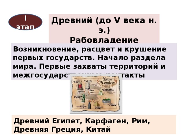
Ancient (before the 5th century AD)
Stage I
Slavery
The emergence, flourishing and collapse of the first states. The beginning of the division of the world. The first seizures of territories and interstate contacts
Ancient Egypt, Carthage, Rome, Ancient Greece, China
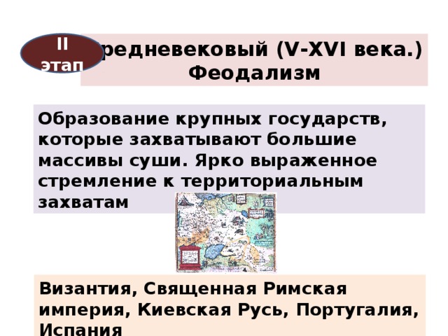
Medieval (V-XVI centuries.)
ΙI stage
Feudalism
The formation of large states that capture large tracts of land. A pronounced desire for territorial conquest
Byzantium, Holy Roman Empire, Kievan Rus, Portugal, Spain
New (XVI - early XX century)
ΙΙI stage
Capitalism
The era of the great geographical discoveries. European colonization. The origin and formation of capitalism. Peace Treaty of Westphalia 1648
England, France, Prussia, Russia, USA
I Ⅴ stage
Newest (XX century)
Capitalism and socialism
Two world wars. The collapse of the world colonial system. The formation and disintegration of the world socialist system. The collapse of the largest empires and territorial changes on the map
USA, Japan, USSR, Germany, China, India, Cuba
Modern (from the end of XX century.)
Ⅴ stage
Capitalism
Formation of a unified Germany, disintegration of Yugoslavia and Czechoslovakia. The collapse of the USSR and the formation of the CIS, "velvet" revolutions in Eastern Europe
Russia, Germany, Czech Republic, Slovakia, Croatia, etc.
It is several millennia old. Many historical eras have passed, so we can talk about the existence of periods in the formation of the political map of the world. Allocate: ancient, medieval, new and modern periods.
The ancient period (from the era of the emergence of the first forms of the state to the 5th century AD) covers the era of the slave system. It is characterized by the development and collapse of the first states on Earth: Ancient, Carthage, Ancient, Ancient Rome, etc. These states have made a great contribution to the development of world civilization. Even then, military action was the main means of territorial change.
The medieval period (V-XV centuries) is associated in our minds with the era of feudalism. The political functions of the feudal state were already more complex and diversified than those of states under a slave system. The internal market was formed, the isolation of the regions was overcome. The desire of states to distant territorial conquests, to the search for new (sea) routes in, was manifested, since overland trade routes to the East (after the fall of Constantinople) were under the control of the Ottoman Empire.
During this period, there were states: Byzantium, the Holy Roman Empire, England, Kievan Rus, etc. The political century changed greatly.
Chronology:
1420s - the first colonial conquests of Portugal: Madeira, Azores, Slave Coast ().
1453 - the fall of Constantinople.
1492-1502 - discovery of America (4 trips to and the northern part). The beginning of the Spanish colonization of America.
1494 - Treaty of Tordesillas - division of the world between Portugal and Spain.
1519_ 1522 - travel around the world and its companions.
It was from the turn of the 15th-16th centuries that the New Period of History began (which lasted until World War I at the beginning of the 20th century).
This was the era of the birth, rise and consolidation of capitalist relations in the world. It marked the beginning of European colonial expansion and the spread of international economic ties throughout the world.
In the era of the Great Geographical Discoveries, the largest colonial powers were Spain and Portugal. But with the development of manufacturing production, England came to the forefront of history, and later. This period of history was characterized by large colonial conquests. The world has been reshaped many times.
The political map of the world became especially unstable at the turn of the 19th and 20th centuries, when the struggle for the territorial division of the world sharply intensified between the leading countries. So, in 1876, only 10% of the territory of Africa belonged to Western European countries, while in 1900 - already 90%. And by the beginning of the XX century. in fact, the division of the world turned out to be completely completed, that is, only its violent redistribution became possible.
The beginning of the newest period in the formation of the political map of the world is associated with the end of World War I (the first stage). The next milestones were World War II, as well as the turn of the 1980s-90s, which is characterized by major changes in the East (the collapse of the USSR, Yugoslavia, etc.).
The first stage was marked by the appearance on the world map of the first socialist state (RSFSR, and later the USSR) and noticeable territorial changes on the political map, and not only in Europe.
Since the beginning of the 90s, the third stage of modern history has been distinguished, which continues to this day. The qualitatively new changes on the political map of the world, which had a great impact on the socio-economic and socio-political life of the entire world community during this period, include the following:
The collapse of the USSR in 1991;
Formation of the Commonwealth of Independent States ();
Implementation of predominantly peaceful ("velvet") people's democratic revolutions of 1989-90. in the countries of Eastern Europe (former socialist countries);
Unification of the Arab states of YAR and NDRY (May 1990) on a national-ethnic basis and the formation of the Yemen Republic with its capital in Sana'a;
Topic: Political Map
Stages of the formation of a political map
Practical work No. 1
Classification of the largest states in the world, by forms, by state. build
Consider the features of various historical eras and stages of the formation of a modern political map of the world, its quantitative and qualitative changes.
Consider a typology of countries based on qualitative characteristics that take into account the level of socio-economic development of the countries of the world.
Consider the variety of countries in the modern world. Explore the different forms of states.
Geopolitics concept.
Equipment: computer, multimedia set-top box, political map of the world, map of hemispheres, atlases.
During the classes
1. Organizational moment.
2. Learning new material.
Slide 3. Characteristics of the main stages of the formation of a modern political map (on the monitor slide "Stages of the formation of a political map of the world" the teacher consistently gives a description of each stage.)
Ancient (before the 5th century AD) - the emergence and collapse of the first states.
Medieval (V-XVI centuries) - the emergence of large feudal states in Europe and Asia.
New (XVI-XIX centuries) - the formation of the colonial empire
The newest (first half of the 20th century) - the formation of socialist countries, the collapse of the colonial system.
Modern, in which there are three main stages:
A) the emergence of the world socialist system, the formation of independent states in Asia.
B) Formation of independent African states.
C) The collapse of the socialist economic system and the ensuing changes on the political map of Europe and Asia.
Slide 4. States are the main object on the political map of the world. The map is a dynamic system, quantitative changes (territorial gains, losses, voluntary concessions) and qualitative changes (change of formation, conquest of sovereignty, introduction of a new state structure) take place here. The teacher tells how these changes have taken place over the past 100 years.
Slide 5, 6, 7. The typology of the countries of the modern world is based on the level of socio-economic development of the state, expressed through the indicator of gross domestic product (GDP) and a synthetic indicator (HDI) - the human development index.
The first group is formed by economically developed countries ( slide 5), which is divided into 3 subgroups:
G7 countries, GDP per capita ranges from 20-30 thousand dollars;
less large countries Western Europe, GDP from 20-30 thousand dollars;
countries of immigration capitalism.
The second group of countries with economies in transition ( slide 6), there are 2 subgroups:
former socialist countries of Eastern Europe;
post-socialist.
The third group is developing countries, which are divided into 6 subgroups:
key countries, GDP is about $ 350;
Latin American countries, some Asian countries and countries North Africa, GDP over $ 1000;
"Asian dragons" - newly industrialized countries;
Oil exporters;
most developing countries in Africa, Asia, Latin America, GDP less than $ 1000;
Least Developed Countries, Gross Domestic Product $ 100 - $ 300.
Consideration of the most common grouping of countries ( slide 8, 9, 10)
Slide 8: They are distinguished by the size of the territory. Students working with maps of atlases give examples.
countries are giants, their area is more than 3 million km 2;
countries are large, with an area of more than 500 thousand km 2;
microstates.
Slide 9: By population
countries - giants - more than 100 million people;
middle countries;
micro-states, the population of which is up to 30 thousand people.
Slide 10: By geographic location... Students working with atlas maps provide examples for each type:
coastal countries
peninsula countries
island countries
inland countries
Slides 11, 12, 13, 14 correspond to the division of modern countries of the world according to the form of government. The teacher characterizes each of the forms of government, highlighting the advantages and disadvantages of each, giving examples for each type.
Republics - presidential, parliamentary, mixed;
Monarchies - constitutional, absolute, theocratic;
Commonwealth;
Slides 15 division of countries according to the peculiarities of the territorial-state structure, characterizing each of the types.
Unitary states(unified legislative and executive power);
Federal state (along with uniform laws, there are separate self-governing entities);
Confederation (a temporary union of states to achieve a common goal).
Slide 16 The teacher characterizes the influence of international relations on the political map of the world. Examines issues related to the change in ideas about geopolitics in recent times. Provides examples of hotspots, looking at the underlying causes. Consider the issues facing political geography and reinforces the concept of geopolitics.
3. Lesson summary.
Students are encouraged to complete tasks on this topic on their own. Slide 17-18.
4. Assignment to the house .
Paragraph 1, on outline map inflict states with a monarchical form of government and federal states in terms of territorial-state structure.