This term is used in relation to the most important geographical discoveries made by European travelers between the 15th and 17th centuries. Geographical discoveries are the search and discovery of new lands previously unknown to people. Here are the reasons that prompted people to do great geographical discoveries starting from the end of the 15th century.
First, at the end of XV - early XVI centuries in Europe, commodity production began to grow at a rapid pace, which led to an increase in demand for raw materials. But since there was not enough raw material in Europe, it became necessary to import it from other countries.
Secondly, the existing trade routes through the Mediterranean Sea, as well as the Great Silk Road that connected Asia with Europe, became extremely dangerous. Control over these routes passed to the Ottoman Empire (Turkey). The challenge facing the Europeans of opening new sea trade routes has become a historical necessity. The modern ships and weapons that existed by this time fully made it possible to implement the plan. The invention of the astrolabe, which began to be used in navigation along with the compass, was also of great importance. During this period, the Italian scientist P. Toscanelli, proceeding from the fact that it is round, created a map of the world. On it, the shores of the Asian continent reached the western part of the Atlantic Ocean. P. Toscanelli believed that by sailing from Europe to the west, one could get to India.
The beginning of great geographical discoveries.
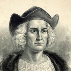
The initiators of the great geographical discoveries were sea travelers from Portugal and Spain. To implement such a grandiose idea, fearless sailors were needed. One of these travelers was a Genoese admiral Christopher Columbus (1451 - 1506). He planned to pave the way to India across the Atlantic Ocean. Columbus managed to conclude an agreement with the royal family of Spain to equip an expedition to find the shortest sea route to India. The king took over the financial support of the expedition. On August 6, 1492, Columbus went to sea in three caravels, leading an expedition.
Discovery of America.
On October 12, 1492, Columbus's expedition landed on one of the islands Caribbean... Columbus named this island San Salvador (now the territory of the Commonwealth Bahamas). Thus, the search for the shortest sea route to India led to the discovery of America. This happened as a result of the mistakes of scientists of the 15th century, in particular Toscanelli, who made a map of the world. The fact is that when determining the length of the equator, P. Toscanelli made a mistake in calculating by 12 kilometers. Subsequently, scientists called this mistake "the great mistake that led to the great discovery."
However, Columbus himself did not understand that in 1492 he sailed not to India, but to America. He believed he had arrived in India. Therefore, he called the indigenous population Indians. Columbus subsequently equipped four more expeditions to India (actually to America). As a result of these expeditions, many new lands were discovered, on which the Spanish flag was raised. These territories became the property of Spain. Columbus was appointed viceroy of these lands. The fact that the new continent was named not Colombia, but America, is associated with the name of the Italian navigator and astronomer Amerigo Vespucci (1454-1512). In 1499 - 1501, as part of a Portuguese expedition, he explored the shores of Brazil and came to the conclusion that discovered by Columbus the land is not India, but a new part of the world. Subsequently, he named the continent named after him the New World. In 1507, the scientist-cartographer M. Waldseemüller proposed to name the new part of the world discovered by Columbus in honor of Amerigo Vespucci - America. This name suited everyone. The first globe on which New World was named "America" was created in Germany in 1515. Subsequently, on other maps, the lands discovered by Columbus began to be called "America".
Subsequent discoveries.
The sea route across the Atlantic Ocean leading to India was opened in 1498. By sea traveler by the Portuguese Vasco da Gama, who sailed from the coast of Spain. In 1519, another Portuguese Fernand Magellan, who began his sea voyage from the coast of Spain, rounded the American continent, opened a new sea route to India. it trip around the world ended in 1522 and finally proved that the Earth is round and most of it is covered with water. And the expedition of L.V. de Torres discovered Australia in 1605.
Significance of great geographical discoveries.
The great geographical discoveries played an important role in the development of many sciences. Geography, history, ethnography, oceanology were replenished with new information and conclusions. Thanks to these discoveries, new trade sea routes were laid. The main sea trade routes that ran through the Mediterranean Sea have now passed into the Atlantic Ocean. These factors contributed to the formation of further world trade.
So, thanks to the Great Geographical Discoveries, the foundation of a global civilization was laid.
Admiral(from the Arabic "amiral-bakhr" - "lord of the sea" - a military rank in the navies.
- an astronomical device used to determine geographic, latitudes and longitudes, as well as the rising and setting of stars.
Vice- assistant, deputy by position.
Opening- search, achievement, making, fundamental changes in the level of knowledge.
1. What, in your opinion, are the preconditions for the Great Geographical Discoveries. What are their main consequences? What is the degree of participation of Russian travelers and researchers
geographical discovery Russian explorer
At the end of the 15th - the middle of the 17th century. there were great geographical discoveries. They are called great because of their exceptional importance for the destinies of Europe and the whole world.
The Age of Discovery is divided into two periods:
The Spanish-Portuguese period (late 15th - mid-16th century). The most important discoveries during this period were: the discovery of America (the first expedition of Columbus in 1492); the opening of the sea route to India - Vasco da Gamma (1497-1498); F. Magellan's first circumnavigation of the world (1519-1522).
The period of Russian and Dutch discoveries (mid-16th - mid-17th century). These include: The discovery by the Russians of all of North Asia (from the Yermak campaign to the voyage of Popov-Dezhnev in 1648), the Dutch Pacific expeditions and the discovery of Australia.
Prerequisites for the Great Geographical Discoveries
Great Geographical Discoveries were prepared all the way economic development Europe. At the end of the 15th century. European trade with the countries of the East was in crisis. With the formation of the Ottoman Empire, the trade routes of the Mediterranean were cut off. In the XV century. countries Western Europe the lack of gold and silver as a means of circulation became acutely felt. The impoverished nobility, which made up the bulk of the conquistadors (conquerors), rushed to the search for new trade routes and gold. The state, in need of money, was forced to go to the costs of financing sea expeditions.
The successes of European science and technology were also an important prerequisite for the Great Geographical Discoveries. First of all, the development of shipbuilding and navigation technology. In the XIV-XV centuries. a caravel intended for ocean navigation was created - a high-speed vessel with spacious holds, navigation instruments - a compass and an astrolabe - were improved, geographical maps were refined, the concept of the sphericity of the Earth was approved.
The consequences of the great geographical discoveries
Geographical discoveries led to profound changes in the European economy.
1. There was a significant expansion of the sphere of world trade (for example: if by 1400 the Europeans knew 50 out of 510 million.
the earth's surface, then by 1500 the surveyed area reached 110 million, and by 1600 - 310 million)2. The commercial development of new lands led to the inclusion of products previously unknown to Europeans in the world trade turnover: tobacco, cocoa, coffee, tea, rice and especially sugar. The volume of trade has increased significantly. (for example: if the Venetians annually delivered more than 200 tons of pepper to Europe, then after the opening of the sea route, up to 7000 tons of spices began to be brought to India.)
3. Great geographical discoveries led to the movement of trade routes to the oceans - Atlantic, Indian and Pacific. Spain and Portugal are at the center of world trade routes. New trade routes across the Atlantic Ocean have increased the importance of the international trade of the Netherlands, England and France.
4. With the expansion of trade, the emergence of many new goods, new forms of trade organization have arisen. A permanently operating market has appeared in Europe - the stock exchange. At first it was a special area for transactions, and in 1531 the building of the stock exchange was erected. Operations with securities were carried out on the exchange.
5. One of the consequences of the Great Geographical Discoveries was the "price revolution" caused by the influx of gold and silver into Europe, which gave a powerful impetus to the initial accumulation of capital in Europe (for example: during the 16th century, the inflow of gold from America to Europe more than doubled , silver - more than threefold) As a result, prices in Spain increased 4.5 times, in England - 4 times, in France - 2.5 times, in Italy and Germany - 2 times. At the same time, prices for agricultural products rose to a much greater extent than for manufactured goods, and basic necessities rose more than luxury goods. This was due to the fall in the value of precious metals as a commodity.
6. Also, as a result of discoveries, a system of colonial rule and colonial exploitation emerged. Initially, the main method of exploitation of the colonies was open robbery. Subsequently, the tax system became widespread. But the main income from the exploitation of the colonies came from trade.
Thus, the Great Geographical Discoveries created the basis for the emergence of the world economy and market, changes in the organization of trade, industry, and the rise of agriculture in European countries.
Participation of Russian travelers and researchers
The Russian people contributed to the great geographical discoveries of the first half of the 17th century. significant contribution. Russian travelers and navigators made a number of discoveries (mainly in northeast Asia) that enriched world science.
The reason for the increased attention of Russians to geographical discoveries was the further development of commodity-money relations in the country and the associated process of the formation of the all-Russian market, as well as the gradual inclusion of Russia in the world market. During this period, two main directions were clearly outlined: northeastern (Siberia and the Far East) and southeastern (Central Asia, Mongolia, China), along which Russian travelers and sailors moved.
The trade and diplomatic trips of the Russian people in the 16th – 17th centuries were of great educational value for contemporaries. to the countries of the East, survey of the shortest land routes for communication with the states of Central and Central Asia and with China.
By the middle of the 17th century. Russians thoroughly studied and described the routes to Central Asia. Detailed and valuable information of this kind was contained in the ambassadorial reports ("article lists") of the Russian ambassadors I.D. Khokhlov (1620-1622), Anisim Gribov (1641-1643 and 1646-1647) and others.
Of great importance in the history of geographical discoveries of that era was the survey of vast areas of the north and northeast of Asia from the Ural ridge to the coast of the Arctic and Pacific oceans, i.e. all over Siberia.
The annexation of Siberia was started in 1581 by a campaign of a detachment of the Cossack ataman Ermak Timofeevich. The government-supported campaign of Ermak (1581-1584) led to the fall of the Siberian Khanate and the annexation of Western Siberia to the Russian state.
Back in the middle of the 16th century. the voyages of Russian polar sailors from the European part of the country to the mouth of the Yenisei are mentioned. They moved along the coast of the Arctic Ocean. Used by Russian sailors of the XVI-XVII centuries. a compass ("uterus") and maps. In the first two decades of the 17th century. there was already a fairly regular water communication of the West Siberian cities. Moving east into taiga and tundra Eastern Siberia, the Russians opened one of largest rivers Asia - Lena. In 1633, brave sailors Ivan Rebrov and Ilya Perfilyev left the mouths of the Lena to the east at night, and reached the river. Yana, and in 1636, the same Rebrov made a new sea voyage and reached the mouth of the Indigirka.
Almost simultaneously, detachments of Russian servicemen and industrial people (Ivanova and others) moved along the mainland in a northeastern direction, opening the aforementioned rivers from land.
An important discovery in northeast Asia ended in the early 40s of the 17th century. expedition of Mikhail Stadukhin. A detachment of the Cossack foreman and merchant Stadukhin, in which Semyon Dezhnev was located, descended on a koch along the Indigirka, in 1643 reached the Kovaya River by sea, i.e. reached the mouth of the Kolyma River. The Nizhne-Kolyma winter hut was founded here, from which, a few years later, the Cossack Semyon Ivanovich Dezhnev and the industrial man Fedot Alekseev (known under the name Popov) set out on their famous voyage around the northeastern tip of the Asian mainland Kochi.
An outstanding event of this era was the discovery in 1648 of the strait between America and Asia, made by Dezhnev and Fedot Alekseev (Popov).
There is reason to believe that Kamchatka in the middle of the 17th century. was discovered by the Russian people. According to later reports, the koch of Fedot Alekseev and his companions reached Kamchatka, where the Russians lived for a long time among the Itelmens. The memory of this fact was preserved among local population Kamchatka, and a Russian scientist of the first half of the 18th century. Krasheninnikov reported about him in his work "Description of the land of Kamchatka". There is an assumption that part of the ships of the Dezhnev expedition, which disappeared on the way to the Chukchi bow, reached Alaska, where they founded a Russian settlement. In 1937, during excavation work on the Kenai Peninsula (Alaska), the remains of three-hundred-year-old dwellings were discovered, which were attributed by scientists to the number of those built by the Russian people.
In addition, Dezhnev and his companions are credited with the discovery of the Diomede Islands, on which the Eskimos lived, and the survey of the Anadyr River basin.
The discovery of Dezhnev - Alekseev was reflected on the geographical maps of Russia in the 17th century, which marked the free sea passage from the Kolyma to the Amur. During the years 1643-1651. the campaigns of the Russian detachments of V. Poyarkov and E. Khabarov to the Amur took place, which delivered a number of valuable information about this river not studied by Europeans.
So, during a relatively short historical period (from the 80s of the 16th century to the 40s of the 17th century), the Russian people passed through the steppes, taiga, tundra through the whole of Siberia, sailed along the seas of the Arctic and made a number of outstanding geographical discoveries.
Bibliography
1. "History of Economics" edited by O.D. Kuznetsova, I.N. Shapkina. - Moscow INFRO - m, 2005
2. "History of the World Economy" edited by G.B. Polyaka, A.I. Markova - M: UNITI, 2006
3.Loyberg M.Ya. "History of Economics" - Moscow INFRO - m, 2001
Significance of the great geographical discoveries: They marked a new era in the geographical exploration of the Earth, gave impetus to the development of many areas of natural science, contributed to the intensification of world trade. Were erased "white spots" on the geographic map of the Earth. The main trade routes were shifted to the oceans. The countries of the Middle East, formerly the "crossroads of civilizations", are now in the backwoods. A "food revolution" took place in Europe, many new crops were introduced: potatoes, corn, tomatoes, sunflowers, a wide import of various spices, coffee, cocoa, tea. The horizons of Europeans expanded thanks to the development of geography, contacts with peoples of different cultures, a better understanding of the diversity of animals and flora... The development of a scientific worldview and the undermining of the authority of the Bible.
Slide 5 from the presentation "Discovery" to the lessons of geography on the topic "Discovery"Dimensions: 960 x 720 pixels, format: jpg. To download a slide for free for use on geography lesson, right-click on the image and click "Save Image As ...". You can download the entire Otkrytie.ppt presentation in a zip-archive of 5066 KB.
Download presentationDiscoveries
"Lazarev" - in 1819 was equipped new expedition to the "South and North Pole". In the Sevastopol. Chronicle of campaigns. Fadey Fadeevich Bellingshausen turned east. From 1843 - Admiral. The mother of the future naval commander was Anna Andreevna Lazareva, nee Chagina. Lazarev was elected an honorary member of the Geographical Society.
"Expeditions" - At that time, GEOGRAPHY performed mainly the function of LANDSCRIPTION, answered the questions: WHAT? Khariton Laptev and Semyon Chelyuskin 1739-1742 The most important routes of the Great Northern Expedition 1734-1742 The era of the great geographical discoveries. Petersburg Academy of Sciences. And it all began with the Peter's decree, which decreed Vitus before the Kamchatka expedition.
"Russian Travelers" - V.I. Roborovsky Collected a huge amount of material on zoology, physical geography, ethnography of the peoples of Asia. A second difficult wintering began, and the strength of the people was undermined. Famous traveler. Potanin G.N. 18.Ber Karl Maksimovich 02/28/1792 - 11/28/1876. Pevtsov M.V. 17. The first essentially Russian economic geographer.
"Geographical discoveries" - Pages 8-14, 22-23 of the textbook. Discovery of a new continent. Christopher Columbus. Finding a way to India. Plan of the Causes of the Great Geographical Discoveries. Great geographical discoveries. Why are the discoveries made in the XY-XYII centuries called great? Why were the great geographical discoveries made in the XY-XYII centuries?
"Ivan Kruzenshtern" - But after a few months I received a negative answer. On November 19, 1770, Adam Johann Kruzenshtern was born on the Hagudi estate. The work was carried out by Belitskaya Alexandra and Yana Lumbe, grade 8B. Alexander I honored to receive I.F.Kruzenshtern. Commemorative medal. Youth. Dreams come true. The Academy of Sciences highly appreciated the results of the first Russian round the world expedition.
Geographical discoveries
finding new geographic features or geographic patterns. In the early stages of the development of geography, discoveries related to new geographic sites... A particularly important role was played by the discoveries of previously unknown parts of the land (territorial discoveries). With the development of geography as a science, discoveries that contribute to the identification of geographical patterns, deepening the knowledge of the essence of geographical phenomena and their interrelationships are gaining more and more importance. Territorial discoveries are closely related to the overall process social development... Their prerequisites, incentives, historical consequences are determined, ultimately, by the method of production of material goods, by the specific economic and political situation. The socio-historical role of territorial discoveries is different at different stages of the development of society. Rudiments geographic knowledge appeared in primitive society, which was reflected in legends and primitive drawings - "maps". Among the peoples of antiquity, who have reached a certain cultural level, the geographical outlook increases so much that ideas about the inhabited world appear, in the center of which the given people lives. In the future, the first scientific ideas about the sphericity of the Earth were born, but still little connected with the development of territorial discoveries, limited by certain regional boundaries, beyond which, according to legend, ends inhabited world(for example, the "ecumene" of the ancient Greeks). Further development of ties between peoples is accompanied by a corresponding expansion of their geographic horizons. This process, which took place under the conditions of a slave-owning and feudal system, is sharply accelerated with the emergence and development of the capitalist mode of production. Scientific ideas about the Earth as a whole are being created, based on the materials of land and sea expeditions. Location of new objects, discovered by expeditions, is set quite accurately relative to any point on the Earth. Territorial discoveries are reflected on the world geographic map. In capitalist society, territorial discoveries are historically associated with the seizure of new lands, the rivalry of colonial powers, and the formation of colonial empires. In the conditions of the socialist mode of production, when the study of the territory is carried out on a national scale and is of a planned nature, territorial discoveries contribute to a more complete and comprehensive use of natural resources and the involvement of new areas in the sphere of social production. In general, in the history of geographical knowledge, territorial discoveries are inseparably linked in the history of geographical knowledge with the process of creating a map of the earth's surface, ranging from drawings of primitive peoples up to modern general geographic maps of the world. Cartographic and literary sources about the territorial discoveries of the peoples of the ancient world and early middle ages, which the history of science has at its disposal, have significant gaps that make it difficult to consistently recreate the course of the discoveries of various parts of the land. For the ancient world, the discoveries of the ancient Egyptians and the peoples of Western Asia, the ancient Greeks and Romans have been relatively more fully studied. There are interesting historical monuments discoveries of the ancient Chinese, Indians, Malays. Some names of ancient travelers who made major discoveries are known. Such are, for example, the Carthaginian Hannon (the first historically known voyage along the western coast of Africa, 6th century BC), the native of Massalia Pytheas (voyage to the North Atlantic, 4th century BC), etc. For the early Middle Ages the discoveries of the Normans, Arabs, and Chinese are comparatively more fully known. In the 13th and 15th centuries. the development of ties between peoples was accompanied by geographically important travels and discoveries by Plano Carpini, V. Rubruk, Marco Polo, Ibn Battuta, Afanasy Nikitin, etc. In 1492 H. Columbus crossed the Atlantic Ocean and reached the Bahamas, Cuba and Haiti (this year is considered the date of the discovery of America). Expeditions of the late 15th and early 16th centuries marked a cardinal milestone in the creation of general geographic ideas about the Earth. Vasco da Gama, the first circumnavigation of the world by F. Magellan and others, as a result of which America (named after Amerigo Vespucci) and the Pacific Ocean appeared on the map; the sea route to India was opened. Associated with the time of initial capitalist accumulation and carried out in the pursuit of profit, these discoveries were of paramount geographical importance. “The frames of the old orbis terrarum have been broken; only now, in fact, the land was discovered¼ “(F. Engels, see K. Marx and F. Engels, Soch., 2nd ed., vol. 20, p. 346). In the creation of a map of the Indian Ocean basin in the 15th and 16th centuries. sailors from East Africa, South and East Asia, Western Europe. They were of decisive importance for the creation of a map of the northern part of Eurasia in the 16th and 17th centuries. discoveries of Russian explorers in S. of Eastern Europe, in Siberia and on Far East... In addition, individual expeditions were associated with the search for the Northern Sea Route (V. Barents and others). By the middle of the 17th century. the strait separating Asia from America was passed (S.I.Dezhnev and F.A.Popov, 1648). Territorial discoveries of the late 15th - 1st half of the 17th centuries (see Great geographical discoveries) were mainly the result of expeditions of a conquest and commercial nature or the result of pioneer campaigns associated with the settlement of new lands. This time was also characterized by numerous sea "travels for discoveries" - the search for new lands in the ocean with the aim of their annexation. A number of such voyages are associated with the search for the legendary Terra australis incognita (Unknown southern earth). At the same time, the beginning of the discovery by European navigators of Australia and New Zealand (A. Tasman and others) was laid. In the 18th and early 19th centuries. a number of expeditions are already closely related to special scientific tasks. Such are, for example, circumnavigation J. Cook, L. Bougainville, the expeditions of J. La Perouse, J. Dumont-D'Urville and others, equipped by rival colonial powers, Great Britain and France, to search for and annex new lands, but which also had the goals of systematic scientific research. The largest scientific expedition of the 18th century. was the Second Kamchatka (Great Northern) Expedition, equipped in Russia (1733-43). Among the territorial discoveries made by its participants is the discovery of the northernmost tip of the Asian continent (Cape Chelyuskin) and many other objects along the northern coast of Eurasia. V. Bering and A. I. Chirikov in this expedition discovered North-West America, as well as the Aleutian Islands and other objects. The discoveries of islands in the Pacific Ocean were continued by Russian round-the-world expeditions, which were initiated by the expedition of IF Kruzenshtern and Yu. F. Lisyansky. The expedition of F. F. Bellingshausen and M. P. Lazarev discovered Antarctica in 1820. In the 19th century. with territorial discoveries associated with the disappearance of the world geographic map extensive "white spots" within the inner regions of Asia (P.P.Semenov-Tyan-Shansky, N.M. Przhevalsky, G.N. Potanin, etc.), Africa (D. Livingston, G. Stanley, etc.) , North America(M. Lewis, D. Thompson, J. Fremont, L. A. Zagoskin and many others). South America(A. Humboldt, R. Schomburgk and others) and Australia (C. Sturt and others). Geographic exploration of these areas pursued commercial, industrial, transport and military purposes. In Africa, for example, they were directly combined with the implementation of colonial conquests by the European powers. Territorial discoveries were made in the 19th century. many expeditions heading to areas little known geographically. However, already in the Humboldt expedition to South America at the beginning of the 19th century. geographic research were more related to the study of the relationship natural phenomena rather than removing "white spots" from a general geographic map. By the end of the 19th century. in general geography, the Arctic and Antarctic regions remained the least known. In the European-Asian Arctic, as a result of the voyages of industrialists and scientific expeditions (P.K.Pakhtusov, A.E. Nordepsheld, T. Long, Yu. Payer, B. Lee Smith, F. Nansen, etc.) archipelagos. A number of territorial discoveries of the 19th century. in the American Arctic associated with the search for the Northwest Passage (J. Ross, W. Parry, J. Franklin, R. McClure and others). The discoveries in Antarctica concerned mainly separate parts of the Antarctic coast. At the beginning of the 20th century. the North (R. Peary) and South (R. Amundsen, R. Scott) poles were reached. V modern times the completion of discoveries associated with the last major "white spots" on the map. Such are, for example, the discoveries by Soviet researchers of the Chersky Ridge (S.V. Obruchev) and other objects in Northeast Asia, the discoveries of the highest peaks of the Tien Shan and Pamir-Alai, etc. Soviet drifting station "North Pole-1" (1937-1938), "blank spots" were removed in the Central Arctic. By the middle of the 20th century. territorial discoveries are made mainly as a result of work on continuous topographic surveys of vast land areas. In this case, aerial photography acquired a decisive role. The most significant territorial discoveries in the 1950s and 1960s. 20th century made in Antarctica. They are associated with the creation of maps of its overglacial and subglacial relief. The possibility of discovering large oro-hydrographic units is now preserved in relatively few parts of the land (for example, the Amazonian lowland). To the fore in the territorial discoveries of the 2nd half of the 20th century. there are already objects that are reflected on a large-scale topographic map. To a certain extent, discoveries related to the mapping of the seabed and oceans (see Atlantic Ocean, Indian Ocean, Arctic Ocean, Pacific Ocean) can be considered analogous to territorial discoveries. Until the 19th century. they were mainly limited to the coastal areas with shallow depths (continental shelf). Individual attempts to measure great depths using a hand lot, which were undertaken in the 16th and 18th centuries, could not yield successful results. In the 19th century. the development of depth measurement technology (the use of a deep-water lot with a detachable cargo) made it possible to carry out a number of measurements in the ocean, associated, in particular, with the laying of the first transoceanic cables. Oceanographic research in the second half of the 19th century. accompanied by the discoveries of individual deep-sea depressions and ocean floor rises. However, only in the 20th century, with the further development of the technique of measuring depths (echo sounder, etc.), discoveries became possible, as a result of which huge "white spots" on the bottom of the oceans disappeared and modern scientific ideas about deep-sea relief were developed. The most significant of these discoveries date back to the 1950s and 1960s. 20th century, when oceanological research acquired a broad systematic character (see. cards"The most important oceanographic expeditions of the 20th century."). An important milestone in their recent history was the International Geophysical Year (1957-59), which contributed to the development international cooperation in the study of the ocean. The main orographic features discovered within the ocean floor include huge abyssal plains, wide swells, deep-sea trenches and mountain ranges that divide the ocean floor into separate basins. It was found that the system of middle ridges found in all oceans is planetary in nature. Separate powerful ridges have also been discovered (for example, the Lomonosov Ridge in the Arctic Ocean). The greatest depths are established within the deep water trenches. Among them, the largest currently known depth ≈ 11022 m ≈ in the Mariana Trench The Pacific discovered by an expedition on board the "Vityaz" in 1957. In 1960, the bathyscaphe "Trieste" reached a depth of 10,919 m at the bottom of this trench. Since the knowledge of the oceanic bottom is much inferior to that of the land, the discoveries of large underwater orographic units, apparently, will accompany oceanological studies in the future. The immediate prospects for the discovery of oro-hydrographic objects of the earth's surface are connected, to a certain extent, with the use of artificial satellites Earth for filming from space. Discovery of regularities in the area of each geographical science have features depending on the object of its study (see. Geography). N. G. Fradkin. The most important geographical discoveries and travels associated with the creation and refinement of the map of the earth (up to the 19th century inclusive) (the country that equipped the expedition and the leader or participants of the expedition are indicated in brackets) Asia and the Arctic regions of Europe 330≈325 BC NS... Hike through the Iranian Highlands to Central Asia and Western India(Macedonia; Alexander.) 325-324 BC NS... Swimming from the mouth of the river. Indus to the mouth of the river. Euphrates (Macedonia; Nearchus and Onesikritus). Beginning 3 c. BC NS... Travel to India. Geographical information about the river basin. Indus and Ganges and about the Himalayas [Syria (kingdom of the Seleucids); Megasthenes]. 138-126 BC NS. Travel to the river. Tarim and Central Asia. (China; Zhang Qian.) 399≈414 ... Travel from China to India and return to China by sea. (China; Fa Xian.) OK. 525... Sailing to India and Ceylon (Byzantium; Cosmas Indikoplov). 629≈647 ... Travel from China to India. (China; Xuanzang.) 851 ... Travel from Siraf. Visiting the Malabar coast, Ceylon, Indochina and South China [Iran (Takhirtzd state); Suleiman]. OK. 870-890... Sailing from Northern Norway to the Terek coast Kola Peninsula... The way to the White metro station was opened (Norway; Oter). 921≈922 ... Travel from Khorezm with the embassy to the Volga Bulgarians through the Caspian and Aral regions. Information about the nature and population [Iraq (Baghdad Caliphate); Ibn Fadlan]. 943≈967 ... Travel to Iran, Mesopotamia and India [Iraq (Baghdad Caliphate); Ibn Hawkal]. 2nd floor 10 c. Journey through the Near and Middle East. (Palestine; al-Mukaddasi.) 1st floor 11 in... Travels in Iran, India, Central Asia(Khorezm; al-Biruni). 1166≈73 ... Travel from Spain to Palestine, Syria, Iraq, Iran [Spain (Navarra); Benjamin Tudelsky]. 1245≈47 ... Travel from Lyon with the papal embassy to Karakorum (Mongolia) (Italy: G. da Plano Carpini). 1253≈56 ... Journey from Palestine to Karakorum. (France; V. Rubruk.) 1271≈95 ... Travel to China. (Italy; Marco Polo.) 1289≈1330 ... Travel with the papal embassy to China (Italy: G. Montecorvino). 1318≈30 ... Travel to China and Tibet. (Italy; Odorico from Pordenone). 1320 ... Sea voyage from Northern Dvina to Northern Norway [Novgorod; Luka (Ignat Malygin)]. 1325≈49 ... Travels in Asia. (Morocco; Ibn Battuta.) 1338≈53 ... Travel with the papal embassy to China (J. Marignolli). 1364 ... Hike across the Urals to the r. Ob and along it to the Karsky m. (Novgorod; S. Lyapa, Alexander Abakumovnch). 1403≈06 ... Travel with the embassy to Samarkand [Castile (Spain); R. Clavijo]. 1405≈31 ... Seven-time voyages of large fleets from China to the countries of South Asia. (China; Zheng He.) 1419≈44 ... Visits to India, Ceylon, Burma, and southern Arabia. (Italy; N. Conti.) 2nd floor 15 in... Multiple voyages to Novaya Zemlya and the beginning of its development (Russia; Pomors). 1466≈72 ... Travel to India; description of nature and population. (Russia; A. Nikitin.) 1483 ... Hike through the Urals and Western Siberia... Swimming on the Irtysh and Ob [Russia; F. Kurbsky (Black), Saltyk Travin]. 1487≈92 ... Journey to Arabia, Iran, and India. (Portugal; P. Coviljan.) ══ 1496 ... Sailing from the Northern Dvina along the coasts of the Kola Peninsula, Northern and Western Norway. Information about natural features(Russia; G. Istoma.) 1498 ... Arrival of the Vasco da Gama expedition to India. (Portugal; Vasco da Gama.) 1499≈1500 ... Hike across the Urals to Western Siberia. First information about the length and direction of the Ural Mountains. (Russia; S. Kurbsky, P. Ushaty, V. Zabolotsky-Brazhnik.) 1500≈20 ... Sea expeditions to India, Indochina, and Indonesia (Portugal; P. A. Cabral, Vasco da Gama, F. Almeida, A. Albuquerque, D. Siqueira, A. Abreu). 1521 ... First visits by Europeans Philippine Islands(Spain; F. Magellan, J. Elcano.) 1557≈62 ... Travels from England via Russia to Bukhara (1557-58) and to Iran (1561-62) (England; A. Jenkinson.) 70s 16 in... Annual voyages to the Spitsbergen archipelago [Russia; P. Nishets (Nikitich)]. Not later than the 70s - early. 80s 16 in... Multiple sea reach of the mouth of the river. Yenisei (Russia; Pomors). 80s 16 in... Systematic voyages to the river. Ob through the Strait of Matochkin Shar (Russia; Pomors). 1581≈84 ... Voyages across the Urals to Western Siberia. (Russia; Ermak Timofeevich.) 1596 ... Sailing to the northwestern coast of West Spitsbergen, along the western and northern shores of N. Land; discovery of the Bear Islands and Prince Charles Land; reaching the Ice Harbor (in the northeast of the island). (Holland; V. Barents.) End 16-19 17th century... Systematic voyages from Arkhangelsk to the r. Taz (to Mangazeya) (Russia; Pomors). 1603≈07 ... Travel from India via Afghanistan to Kashgaria, Central China and Turpan (Jesuit B. Goish). 1613≈17 ... Research about. Edge and the discovery of the Northeast Land, Svalbard. (England; T. Edge.) 1614≈15 ... Discovery and research about. Jan Mayen (Holland and England; J. May and R. Fotebri). 1616≈26 ... Travel to Syria, Palestine, Mesopotamia, Iran, and India. (Italy; P. della Balle.) 1618≈19 ... Travel to Mongolia and China. Information about the Sayan, lake. Ubsu-Nur. (Russia; I. Petlin.) OK. 1620... Sea bypass of the Taimyr Peninsula (Russia; industrial sailors). 1620≈23 ... Reaching the origins of the river. Lower Tunguska and middle reaches of the river. Lena (Russia; Lenda and other explorers). 1633≈35 ... Swimming down the river. Lena, reaching her mouth and pp. Olenek and Yana. (Russia; I. Perfiliev, I. Rebrov.) 1636≈41 ... Travel through the ridges on the rr. Yana and Indigirka (Russia; Ivanov Posnik). 1636≈63 ... Six journeys to the countries of the Middle East and India. (France; J. Tavernier.) 1638 ... Swimming from the mouth of the river. Yana to the mouth of the river. Indigirka. (Russia; I. Rebrov.) 1639 ... The first voyage of Europeans off the eastern shores of about. Honshu. (Holland; M. Kwast, A. Tasman.) 1639≈41 ... Reaching from land through the ridge. Dzhugdzhur Okhotsk m. (1639). Swimming along its coasts. The first Russian information about the Amur. (Russia; I. Moskvitin.) 1641≈44 ... Travel to the river. Aldan, achievement r. Kolyma. (Russia; M. Stadukhin, S. Dezhnev.) 1643 ... Reaching the lake. Baikal. Visit about. Olkhon (Russia; Kurbat Ivanov.) 1643 ... The first voyage of Europeans off the coast of about. Hokkaido, southern group Kuril Islands(across the Freeze Strait) and South Sakhalin(Holland; M. Freese.) 1643≈46 ... Swimming along the river. Zeya, Amur, along the shores of the Okhotsk m. To the river. Hives. (Russia; V. Poyarkov.) 1648 ... Swimming from the mouth of the river. Kolyma in Beringovo c. First ascent of the Bering Strait [Russia; Popov (F. Alekseev), S. Dezhnev]. 1648 ... Reaching the mouth of the river. Anadyr. (Russia; S. Dezhnev.) 1649≈52 ... Crossing the Stanovoy ridge. Swimming along the river. Amur. Information about the Amur Region. (Russia; E. Khabarov, I. Nagiba.) 1654≈58 ... Travel to Mongolia and China. Information about nature and population. (Russia; F. Baikov.) 1655 ... Discovery of Fr. Krestovsky (Bear Islands). (Russia; Y. Vyatka.) 1656≈64 ... First in European geographical literature information about Nepal and the central Himalayas (Jesuits I. Gruber and A. Orville). 1662≈68 ... Hiking from the river. Anadyr into the interior of the Kamchatka Peninsula [Russia; I. Merkuriev (Rubets)]. 1675≈78 ... Travel through Western and Eastern Siberia, the Far East to Manchuria and China. Route inventory, drawing up a drawing. (Russia; N. Spafari.) 1697≈99 ... First description of the nature and population of Kamchatka. (Russia; V. Atlasov.) 1711≈13 ... Sailing to the northern group of the Kuril Islands. Drawing up their first Russian drawing. (Russia; D. Anfitserov, I. Kozyrevsky.) 1712 ... Reaching the Big Lyakhovsky Island. (Russia; M. Vagin, Y. Permyakov.) 1713≈14 ... Start of development Shantar Islands(Russia; I. Bykov, A. Krestyaninov.) 1714≈15 ... Inventory of the eastern and northern coasts of the Caspian. Discovery of the ancient river bed. Amu Darya (Uzboy) and Kara-Bogaz-Gol gulf [Russia; A. Cherkassky (A. Bekovich-Cherkassky)]. 1716≈21 ... Travel from India to Tibet; information on the orography and hydrography of Southern Tibet (Jesuit I. Desiderius). 1718 ... Inventory east coast Caspian. (Russia; A. Kozhin, V. Urusov.) 1719≈20 ... Expedition to the Caspian Cape. Description of its western and southern shores. Compilation of a consolidated map of the entire sea. (Russia; K. Verdun, F. Soimonov.) 1719≈21 ... Expedition to South Siberia, sailing to the Kuril Islands. Compilation by scientific methods of the first map of a part of southern Siberia, Kamchatka, and the Kuril Islands. (Russia; I. Evreinov, F. Luzhin.) 1720≈27 ... Expedition across the Urals, Western and Eastern Siberia. First studies of nature and information about permafrost. (Russia; D. Messerschmidt.) 1722≈24 ... Travel to Dzungaria. Drawing up a map of the river basin. Tarim, Yarkand-darya, and others, lakes Balkhash and Issyk-Kul. (Russia; I. Unkovsky.) 1725≈30 ... The first Kamchatka expedition. Passage through the Bering Strait (1728) from the south to the north. Ratmanov. Compilation of a reliable map of the extreme S.-V. Asia. (Russia; V. Bering, A. Chirikov, M. Shpanberg.) 1726 ... Research and descriptions of the Caspian Sea and adjacent territories. (Russia; F. Soimonov.) 1733≈43 ... Second Kamchatka (Great Northern) expedition, consisting of several large detachments. (Russia; V. Bering, A. Chirikov, M. Shpanberg.) 1733≈43 ... Academic detachments that worked in the south, west and east of Siberia. Comprehensive studies of nature and population (G. Miller, I. Gmelin). 1734≈42 ... Naval units. Inventory and mapping of the coasts and some adjacent areas from Arkhangelsk to Cape B. Baranov, r. Anadyr with a swimming pool. Discovery and description of Cape Chelyuskin (S. Malygin, D. Ovtsyn, F. Minin, D. Sterlegov, V. Pronchishchev, H. and D. Laptev, S. Chelyuskin, etc.). 1737≈41 ... Comprehensive studies of the nature and population of Kamchatka (S. Krasheninnikov). 1738≈39 ... Sailing to the Kuril Islands and Japan. Description of a part of their shores (M. Shpanberg, V Walton). 1740≈43 ... Studies of the fauna and nature of Kamchatka and about. Bering (G. Steller). 1741 ... Opening of the sea route from Kamchatka to North America, part of its north western shores and some islands in the north of the Pacific Ocean (V. Bering, A. Chirikov). 1740≈41 ... Expedition from Orenburg to Khiva. Information about the nature of the Aral Sea region, compiling it detailed map(Russia; D. Gladyshev, I. Muravin.) Between 1740 and 1760... First voyage around Novaya Zemlya. (Russia; S. Loshkin.) 1761≈67 ... Expedition to Syria, Iran, India. First in European literature geographic information about Yemen. (Denmark; K. Niebuhr.) 1763≈65 ... Compilation of a map of the Chukotka Peninsula. (Russia; N. Daurkin.) 1764≈66 ... Visit for scientific purposes about. Western Svalbard. (Russia; M. Nemtinov.) 1768≈69 ... The first scientific expedition to New earth... Description of the Matochkin Shar Strait and part of the western coast of Novaya Zemlya. (Russia; F. Rozmyslov, Y. Chirakin, M. Gubin.) 1768≈74 ... Academic expeditions. Comprehensive studies of the nature and population of European Russia, the Caucasus, the Urals, Kazakhstan, Siberia (Russia). 1768≈72 ... Study of the Middle and Southern Urals, Northwestern Kazakhstan, northwestern and northern coasts of the Caspian Sea (I. Lepekhin, N. Ozeretskovsky). 1768≈74 ... Study of the Middle and South Urals, North-West Kazakhstan, South-West and East Siberia, the northern coast of Asia (P. Pallas, V. Zuev). 1768≈74 ... Study of Siberia and Lake Baikal (I. Georgi). 1768≈74 ... Study of the Caucasus, Transcaucasia, western and southern coasts of the Caspian (S. Gmelin). 1768≈74 ... Study of the Middle Urals, a part of Southwest Siberia (I. Falk). 1768≈74 ... Study of European Russia, Caucasus, Transcaucasia [I. Guildenstedt (Guldenstedt)]. 1772≈73 ... Compilation of the first hydrographic map of the lake. Baikal and adjacent regions. (Russia; A. Pushkaryov.) 1774≈82 ... Travels in Central and Central Asia and North India. (Russia; F. Efremov.) 1778 ... Sailing through the Bering Strait to the Chukchi m. (Great Britain; J. Cook.) 1779, 1789≈91 ... Journey through Chukotka and sailing to Alaska. (Russia; I. Kobelev.) 1785≈93 ... Exploration and descriptions of Northeast Asia (the Chukchi Peninsula, parts of the shores of the Okhotsk Sea and the North Pacific, and the Aleutian Islands). (Russia; I. Billings, G. Sarychev, R. Gall, and K. Bering.) 1787 ... Pacific voyage, during which the southern and eastern shores of about. Sakhalin, and the La Perouse and Tatarskii Straits are described. (France; J. La Perouse.) 1804≈05 ... Description of the north-western coast of Sakhalin, parts of the coast Japanese islands... Clarification of the outlines of Kamchatka and the northern group of the Kuril Islands. (Russia; I. Kruzenshtern.) 1809≈12 ... Exploration and descriptions of the New Siberian Islands. (Russia; M. Gedenshtrom, Y. Sannikov.) 1811 ... Inventory of part of the Kuril Islands and compilation of a consolidated map of the entire ridge. (Russia; V. Golovnin.) 1819 ... First crossing by Europeans (from east to west) of the Arabian Peninsula. (Great Britain; J. Sadlier.) 1820≈21 ... Swimming in the North Pacific. Explorations and descriptions of the extreme northeastern regions of Asia. (Russia; M. Vasiliev and G. Shishmarev.) 1820≈24 ... Exploration and description of the coast of Asia from the mouth of the river. Indigirka to the Kolyuchinskaya Bay. Scientific and theoretical prediction of the existence of about. Wrangel [Russia; F. Wrangel, F. Matyushkin, P. Kozmin (Kozmin)]. 1820≈30 ... Journey to Syria, Iran, Iraq, and India, crossing the Hindu Kush ridge and the Karakum Desert. (Hungary; S. Kareshi.) 1821≈24 ... Compilation of a map of the western coast of Novaya Zemlya. (Russia; F. Litke.) 1825≈26 ... Mapping of the Ustyurt plateau and adjacent lands. (Russia; F. Berg, P. Anjou, E. Eversman.) 1827≈28 ... Explorations and descriptions of the northeastern coasts of Asia from Avacha Bay to the Chukotka Peninsula and many islands in the western part of the Bering Sea. (Russia; F. Litke.) 1829≈31 ... The first scientific research and mapping of the Shantar Islands [Russia; P. Kozmin (Kozmin)]. 1830≈56 ... Determination of the heights of a number of peaks of the Himalayas, including highest point Lands ≈ the city of Chomolungma. (Great Britain; D. Everest, E. Vo.) 1832≈35 ... Expeditions to Novaya Zemlya, the first survey of the entire eastern coast, Matochkin Shar Strait. Discovery of the Pakhtusov Islands. (Russia; P. Pakhtusov, A. Tsivolka.) 1832, 1836 ... Research, inventory, and mapping of the entire eastern coast of the Caspian Sea. (Russia; G. Karelin.) 1837 ... Comprehensive naturalist. exploration of Novaya Zemlya. (Russia; K. Baer.) 1842 ... Journey through Altai, his physical, geographical, and geological investigations. (Russia; P. Chikhachev.) 1842≈45 ... Comprehensive studies of the nature of the Taimyr Peninsula, the Stanovoy Range, the Aldan Upland, the western coast of the Okhotsk Cape, and the Shantar Islands. (Russia; A. Middendorf.) 1843 ... Explorations of the Hadhramaut region in Arabia. (Bavaria; A. Wrede.) 1844≈65 ... Study of the orography and geology of the Transcaucasus. (Russia; G. Abikh.) 1845≈48 ... Desert survey B. Nefud [Egypt (?); G. Wallin]. 1846≈63 ... Studies of the relief of Asia Minor and the features of its orography. (Russia; P. Chikhachev.) 1847≈48, 1850 ... Expedition to the Northern and Polar Urals. Inventories that served as the basis for compiling a map of part of the Urals. (Russia; E. Hoffman, M. Kovalsky, N. Strazhevsky.) 1848≈49 ... Descriptions of the Aralsky m. Discovery of the island. Revival, and others. (Russia; A. Butakov.) 1848≈49 ... Proof of the insular position of Sakhalin and the availability of the mouth and estuary of the Amur for large vessels. (Russia; G. Nevelskoy.) 2nd floor 19 in... Hydrographic works and inventories of coasts and islands of Russian possessions in the northwestern part of the Pacific Ocean, including the Peter the Great Bay, the Amur estuary, etc. [Russia; officers of the sea. fleet (F. Maydel and many others)]. 1850≈55 ... Explorations and descriptions of the Amur, Sakhalin, the straits surrounding it, the opposite shores of the mainland and part of the Primorsky Territory. (Russia; G. Nevelskoy, N. Boshnyak, D. Orlov with officers of the navy.) 1853≈55 ... Research pp. Vilyui and Amur, and their adjoining regions. (Russia; R. Maak.) 1853≈57 ... Study of the flora and fauna of the river valley. The Volga and the Caspian m. With part of the adjacent regions of the Urals. (Russia; K. Baer, N. Danilevsky, A. Shultz.) 1854 ... Description of the east coast of Korea. Discovery of the Posiet and Olga bays and the Rimsky-Korsakov Islands. (Russia; E. Putyatin and I. Unkovsky.) 1854≈56 ... Biogeographic and meteorological observations in the Amur Region and Sakhalin. (Russia; L. Shrenk.) 1854≈57 ... Travel to India and Central Asia. Exploration of the southern slope of the central Himalayas, crossing the Karakorum mountain range (Great Britain; brothers A., G., and R. Schlagintweit). 1855≈62 ... Orographic, physical-geographical and geological research mainly in Eastern Siberia and the Far East (Russia; Siberian Expedition of the Geogr. Society). 1856≈57 ... Exploration of the Tien Shan (Lake Issyk-Kul, the upper reaches of the Syr Darya, the establishment of the headwaters of the Chu River). (Russia; P.P. Semyonov-Tyan-Shansky.) 1858 ... The first Russian detailed study of R. Ussuri. (Russia; M. Venyukov.) 1858≈59 ... Travel to Kashgaria through the Tien Shan, exploration of the Takla-Makan desert. (Russia; Ch. Valikhanov.) 1858≈72 ... Visits to Svalbard five times. (Sweden; A. Nordenskjold.) 1860≈61 ... Botanical-geographical research of the Caucasus. (Russia; F. Ruprecht.) 1863≈66 ... Physico-geographical and geological research pp. Cupid, Sungari, Ussuri and others, B. Khin-gan. East Sayana. (Russia; P. Kropotkin.) 1864 ... Journey to Arabia. (Italy; K. Guarmani.) 1865≈66 ... Travel through southern and southwestern Tibet, instrumental survey of vast territories in the Himalayas. (Great Britain; Nain Singh.) 1865≈77 ... Explorations and descriptions of the coasts of East Asia. (Russia; K. Staritskii and M. Onatsevich.) 1866≈68 ... Explorations of the Kyzyl Kum Desert of the Tien Shan. (Russia; N. Severtsov.) 1866≈68. Research R. Mekong. (France; E. Doudard de Lagre and M. Garnier.) 1867 ... First inventory south coast O. Wrangel. (USA; T. Long.) 1867≈69 ... Travel across the Ussuri region. Comprehensive studies of the nature of pp. Ussuri and Suchan and their basins. (Russia; N. Przhevalsky.) 1868≈71 ... "Turkestan" expeditions. Exploration of the Kyzylkum desert, Tien Shan, high-mountainous Kuhistan, Alay ridge. Discovery of the Trans-Alai Range. (Russia; A. Fedchenko.) 1868≈72 ... Seven travels to the interior regions of China. (Germany; F. Richthofen.) 1869≈75 ... Physico-geographical and geological studies of the basins of a number of rivers in Eastern Siberia (Angara, Niz. Tunguska, Olenek, etc.) and the ranges of the Eastern Sayan and Khamar-Daban. (Russia; A. Chekanovskii.) 1870≈85 ... Central Asian expeditions (Mongolian 1870-73; Lobnor, or Dzungarian, 1876-77; First Tibetan 1879-80; Second Tibetan 1883-85), which passed through the deserts and mountains of Mongolia, China, and Tibet. Descriptions of nature and population, and the discovery of individual ridges. (Russia; N. Przhevalskiy.) 1871≈72, 1880 ... Explorations of Svalbard and Franz Josef Land. (Great Britain; B. Lee Smith.) 1872≈74 ... Swimming in the Arctic, discovery of Franz Josef Land. (Austria; J. Payer.) 1873≈76 ... Exploration of the ranges of the Eastern Sayan and Khamar-Daban, Priangarye, and others. (Russia; I. Chersky.) 1875≈79 ... Survey of the Najd Desert and the northwestern part of the Arabian Peninsula. (Great Britain; C. Doughty.) 1876, 1878≈79 ... Integrated research and geodetic work in Mongolia and North China. (Russia; M. Pevtsov.) 1876≈77, 1884≈86 ... Comprehensive studies of Mongolia, northern China, and the outskirts of Tibet. (Russia; G. Potanin.) 1877≈79 ... The first penetration of a European into central part Pamir. Research into nature, including orography, and fauna. (Russia; N. Severtsov.) 1877≈82 ... Travels in Eastern Siberia. Exploration of the coasts of Lake Baikal, the basin of the river. Selenga, the upper reaches of the Lower Tunguska, and others. (Russia; I. Chersky.) 1878≈80 ... Travel to India, Indonesia, Japan, China and Burma. Survey of the upper course of the river. Yangtze. (Hungary; B. Széchenyi.) 1878≈82 ... Travels in Tibet from Lhasa to the headwaters of the river. Yangtze and Huang He. (Great Britain; Kishen Sing.) 1881 ... Discovery of the De Long Islands. (USA; J. De Long.) 1881 ... Inventory of eastern, western and b. hours of the northern coast of about. Wrangel. First exploration of its interior. (USA; R. Berry.) 1883≈88 ... Physico-geographical, archaeological, and geological investigations of the southern, western, and eastern regions of Siberia. (Russia; D. Klements.) 1885≈86 ... Exploration of the coast between the rivers. Lena and Kolyma, Novosibirsk Islands. (Russia; A. Bunge, E. Toll.) 1886≈87 ... Journey from Manchuria to India via Mongolia and western China. (Great Britain; F. Younghusband.) 1886≈88 ... Oceanographic research in the Pacific Ocean. (Russia; S. Makarov.) 1886≈88 ... Exploration of the Karakum Desert and ancient valley Uzboy. (Russia; V. Obruchev.) 1889≈90 ... Travels in Central Asia. Explorations and partial descriptions of Mongolia, the Taklamakan Desert, the Kunlun Mountains, and the outskirts of Tibet. (Russia; M. Pevtsov, V. Roborovskii, P. Kozlov.) 1889≈90 ... Explorations and descriptions of the Eastern Tien Shan, Nanshan, Turfan depression, and Beishan highlands. (Russia; G. and M. Grumm-Grzhimailo.) 1891 ... Exploration of the Momsky ridge, the Nersky plateau, the Tas-Kystabyta and Ulankhan-Chistaya ridges. (Russia; I. Chersky.) 1892≈94 ... Orographic and geological exploration of Central Mongolia, the Gobi Desert, Ordos, Tsaidam, Lake Kukunor, Mong. Altai, eastern Kunlun, and Nanshan. (Russia; V. Obruchev.) 1892≈96, 1898 ... Physico-geographical and geological research during a number of routes in Mongolia. (Russia; D. Klements.) 1893≈95 ... Journey through Central Asia, including the Eastern Tien Shan, Kashgaria, the Turfan depression, and Nanshan. (Russia; V. Roborovskiy, P. Kozlov.) 1893≈97 ... Travel to the Tarim Basin, Tibet, Tsaidam, Ordos and Gobi; survey of the Taklamakan Desert and Lopnor and Kukunor lakes. (Sweden; S. Gedin.) 1895≈99 ... Orographic, glaciological, and botanical investigations of Altai. (Russia; V. Sapozhnikov.) 1898≈99 ... Establishment of vertical zoning of soils in Transcaucasia and the B. Caucasus. (Russia; V. Dokuchaev.) 1899≈1901 ... Travel to Mongolia and Tibet. Explorations and descriptions of the Mongolian Altai, Central Gobi, Tsaidam, and eastern Tibet. (Russia; P. Kozlov.) 1899≈1902 ... Comprehensive physical, geographical and biological studies of the Aral Sea. (Russia; L. Berg.) 1899≈1902 ... The second trip to Xinjiang and northern Tibet, survey of the river. Yarkand and the crossing of central Tibet from the lake. Selling to the Karakorum. (Sweden; S. Gedin.) D. M. Lebedev, J. M. Light. Africa 15th century BC NS... Treks to the south, up the Nile, up to the 5th threshold (Egypt; generals of the kings of the 18th dynasty). No later than the 8th century. BC NS... Discovery of the entire northern coast of Africa and the Strait of Gibraltar. (Phenicia; unknown sailors). Until 594 BC NS... Three-year voyage around Africa (Egypt; Phoenician sailors). OK. 525 BC NS... (according to other data, in the 5th century BC). Sailing from Carthage along the western coast of Africa beyond Cape Verde (possibly to the Gulf of Guinea) (Carthage; Hannon). 2 c. BC NS. Opening Canary Islands(Spain; Cadiz fishermen.) OK. 20 BC NS... Hike to the oases of Fezzan, Central Sahara. (Rome; L. K. Balbus.) OK. 42... Crossing of the High Atlas. (Rome; S. Paulin.) OK. 50≈100... Sailing along the east coast of Africa to about. Zanzibar (Rome; Greek sailors). OK. 60... Trekking up the White Nile for 10╟ s. NS. (Rome; unknown warriors.) OK. 340... First Christian mission to Ethiopia. (Byzantium; Frumentius.) 8-9 centuries... Discovery of the Comoros, Madagascar, and the coast of Mozambique. (Iraq; Arab sailors). 60s 11 in... Crossing the Sahara from the Atlas Mountains to the river. Niger (military campaign in Mali) (Morocco; Berber generals). 1312≈41 ... Rediscovery of the Canary Islands (Italy and Portugal; Genoese sailors). 1344 or 1345... Discovery of the Madeira Islands. (Italy; unknown sailors.) 1352≈53 ... Crossing Western Sahara to the river. Niger (from south to north) and Center. Sahara. (Morocco; Ibn Battuta.) 1431≈35 ... Discovery of the Azores (Portugal; captains of Prince Henry the Navigator). 1434≈57 ... Sailing south along the coast West Africa up to 10╟ s. NS. Discovery of Cape Verde, pp. Senegal and Gambia, Bijagos Islands (Portugal; captains of Prince Henry the Navigator). 1456≈62 ... Discovery of the Cape Verde Islands (Italy, Portugal; A. Cadamosto, A. Noli, D. Afonso). OK. 1461≈73... Promotion to the south-east. along the coast of Africa to the Gulf of Biafra and in the south to 2╟ S. NS. Discovery of the Cameroon volcano and the islands in the Gulf of Guinea. (Portugal; P. Sintra, S. Costa, J. Santarem, R. Siqueira, F. Po.) 1482≈86 ... Advance along the western coast of Africa to 22╟ S. NS. The opening of the lower reaches of the river. Congo (Portugal, D. Kahn). 1487≈88 ... Discovery of the southern coast of Africa and the Cape Good Hope(Portugal; Bartolomeu Dias.) 1489≈93 ... Sailing from the Somali Peninsula along the east coast of Africa to 20╟ S. NS. and a journey from there to Ethiopia. (Portugal; P. Covillan.) 1497≈98 ... First voyage from Europe to India around Africa. Completion of opening coastline Africa. (Portugal; Vasco da Gama.) 1500 ... The first visit by Europeans to Fr. Madagascar. (Portugal; Diogo Dias.) 1501≈07 ... Discovery of the Ascension Islands, St. Helena, Amirante, Seychelles and Mascarene (Portugal; J. Nova, P. Mascareñas, and others). 1511≈15 ... Travel through the Sahara to the r. Niger and Lake Chad (Morocco; African Lion). OK. 1570... Study of the lower course of the river. Zambezi. (Portugal; F. Barreto.) 1613 ... Exploration of the lake. Tana and the headwaters of the Blue Nile [Portugal; P. Paes (Paisch)]. 1616 ... Discovery of the lake. Nyasa and R. Ruvuma. (Portugal; G. Bocarro.) 1648≈61 ... Exploration of eastern Madagascar. (France; E. Flacour.) 1652≈62 ... Discovery of the Cape Mountains and the M. and B. Karoo plateau. (Holland; J. Riebeck and others.) 1714≈16 ... Study of the river basin Senegal. (France; A. Bru.) 1760≈61 ... Hike beyond the river. Orange. Discovery of the B. Namaqualand plateau. (Holland; Cape colonists.) 1769≈72 ... Exploration of the Ethiopian Highlands. (Great Britain; J. Bruce.) 1787 ... Study of the river basin Cunene (Portugal: F. Lacerda). 1791≈92 ... Discovery of the Namib Desert. (Holland; Cape colonists.) 1795≈97, 1805≈06 ... Travel from the mouth of the river. Gambia to Upper Niger; sailing across the Niger from the city of Segu to the rapids of Busa (Lala). (Great Britain; M. Park.) 1812 ... Discovery of the origins of the river. Limpopo and the Witwatersrand watershed. (Great Britain; D. Campbell.) 1818≈23 ... Discovery of the upper reaches of the river. Gambia, Senegal, and Niger on the Fouta Jallon plateau. (France, Great Britain; G. Molien, A. Leng.) 1822≈25 ... Double crossing of the Sahara. Exploration of the lake. Chad and the Chad-Niger watershed. (Great Britain; D. Denem and H. Clapperton.) 1827≈28 ... Crossing of West Africa from Sierra Leone to Morocco. (France; R. Caye.) 1830 ... Study of the lower reaches of the pp. Niger and Benue. (Great Britain; brothers R. and D. Lander.) 1836≈40 ... Study of interfluves pp. Orange ≈ Vaal, Vaal ≈ Limpopo (Transvaal) and Drakensberg Mountains ( South Africa; A. Pretorius, P. Retif and other leaders of the Boer settlers). 1837≈48 ... Exploration of the Ethiopian Highlands. (France; brothers Antoine and Arnaud Abbadi.) 1848≈49 ... Exploration of the Kilimanjaro and Kenya massifs. (Germany; I. Krapf.) 1849≈54 ... Crossing the Kalahari Desert. Study of the upper reaches of the river. Zambezi. (Great Britain; D. Livingston.) 1849≈55 ... Exploration of the river network of Angola. (Hungary; L. Magyar.) 1850≈53 ... Crossings of the Kalahari and Damara Highlands. (Sweden; K. Anderson.) 1850≈55 ... Exploration of the Sahara, the area of the lake. Chad, headwaters of the river. Benue and Central Sudan to r. Niger. (Great Britain; D. Richardson, A. Overweg, G. Barth.) 1852≈53 ... Crossing Africa from Benguela (Angola) to the mouth of the river. Ruvuma (Portugal; A. Silva Porto.) 1854≈56 ... Crossing Central Africa from the city of Luanda (Angola) to the mouth of the river. Zambezi. Discovery of Victoria Falls. (Great Britain; D. Livingston.) 1856≈63 ... Exploration of the lake. Tanganyika. Discovery by Europeans of the lake. Victoria and R. Victoria Nile. (Great Britain; R. F. Burton, J. Speke, J. Grant.) 1859≈61 ... Completion of the discovery of Lakes Nyasa and Shirwa. (Great Britain; D. Livingston.) 1864 ... The opening of the r. Albert Nile and Lake Albert (Great Britain; S. Baker.) 1865≈70 . Comprehensive research Madagascar [France; A. Grandidier (father)]. 1867≈71 ... Discovery of lakes Mveru and Bangweulu and r. Lualaba (upper Congo). (Great Britain; D. Livingston.) 1869≈74 ... Exploration of the Tibesti Highlands. (Germany; G. Nachtigall.) 1870 ... Research R. Knot (main source of the Ubangi River). (Germany; G. Schweinfurt.) 1873≈75 ... Crossing of Central Africa in the strip 6╟30 "≈12╟30" S. NS. and the study of its relief. Completion of the opening of the lake. Tanganyika. (Great Britain; W.L. Cameron.) 1875≈77 ... The opening of the r. Kagera, lake Edward and the Rwenzori massif. Swimming along the river. Congo from headwaters to mouth. (Great Britain and the USA; G. Stanley.) 1875≈92 ... Study of the river basin Ogove and northern right tributaries of the Congo. (France; P. Brazza.) 1877≈79 ... Crossing Africa from Angola to Mozambique, exploration of the river basin. Cubango. (Portugal; A. Serpa Pinto.) 1878≈83 ... Exploration of the Great Graben. Discovery of the lake. Rukwa. (Great Britain; D. Thomson.) 1880≈83 ... Research R. The node and part of the watershed between the rivers. Nile and Congo. (Russia; V. Juncker.) 1883≈1900 ... Exploration of the Sahara, pp. Sharpe and Ubangi. (France; F. Foureau.) 1884≈86 ... Research R. Kasai (Belgium; G. Wiesmann.) 1884≈86 ... Research of pp systems. Ubangi and Lomami. (Belgium; J. Grenfell.) 1888 ... Discovery of the lake. Rudolph. (Hungary; S. Teleki.) 1892≈97 ... Exploration of the Somali Peninsula and the river basin. Juba. (Italy; V. Bottego.) 1894 ... Discovery of the lake. Kivu. (Germany; A. Getzen.) 1897≈99 ... Exploration of the lake basin Rudolph, pp. Juba, Sobat and Omo. (Russia; A. Bulatovich.) 1898≈1902 ... Exploration of the western and southern regions of about. Madagascar [France; G. Grandidier (son)]. I.P. Magidovich. North and South America OK. 900... Maiden voyage to the eastern coast of Greenland. (Norway; Gunbjörn Ulfson.) 981≈983 ... Opening of the southern and southwestern Greenland(Iceland; Eirik Torvaldson.) 985 ... Maiden voyage to North-East America. (Norway; Bjarni Herulfsson.) 1000≈1001 ... Discovery of Markland [Newfoundland (?)] And Vinland [eastern coast of North America (?)] (Greenland; Leif Erikson). Before 1207... Discovery of the western coast of Greenland up to 74╟ s. NS. and Disko Bay. (Greenland; Normans.) 1492 ... Discovery of the Bahamas, the northeastern coast of Cuba and about. Haiti. (Spain; H. Columbus, M. and V. Pinsons.) 1493 ... Discovery of the islands of Dominica, Guadeloupe, Virgin Islands, and Puerto Rico. (Spain; J. Columbus.) 1494 ... Discovery of Fr. Jamaica and the southern coast of Cuba from 74╟ to 84╟ W. (Spain; H. Columbus.) 1497≈98 ... Voyages along the eastern coast of North America. (England; J. Cabot, S. Cabot.) 1498 ... Discovery of Fr. Trinidad and a section of the northern coast of South America from the Orinoco Delta to about. Margarita (Paria and Araya Peninsula). (Spain; H. Columbus.) 1499 ... Discovery of the coast of Guiana and the Caribbean coast of South America up to 72╟W. with the Gulf of Venezuela, the Paraguana and Guajira peninsulas, and a number of islands, including Curacao. (Spain; A. Ojeda, A. Vespucci.) 1500 ... Discovery of the northern coast of Brazil, the Marajo Islands and others in the delta of the river. Amazon and its estuaries. (Spain; V. Pinson.) 1500 ... Discovery of the eastern coast of Brazil between 6╟ and 10╟ S. NS. (Spain; D. Lepe.) 1500 ... Discovery of a section of the eastern coast of Brazil at 17╟ S. NS. (Portugal; P. Cabral.) 1501 ... Completion of the discovery of the Caribbean coast of South America (up to the Gulf of Uraba). The opening of the mouth of the river. Magdalena. (Spain; R. Bastidas.) 1501≈02 ... Discovery of the coast of Brazil from 10╟ to 25╟ S. sh., the mouth of the river. São Francisco, Todusus Santos Bay and Guanabara Bay (Rio de Janeiro) (Portugal; expedition with the probable participation of A. Vespucci). 1502≈03 ... Discovery of the Martinique and Caribbean islands, the coasts of Honduras, Nicaragua, Costa Rica, and Panama to the Gulf of Uraba. (Spain; J. Columbus.) OK. 1504... Discovery of the Gulf of St. Lawrence, the N. Scotland Peninsula and about. Cape Breton (France; Breton fishermen). 1508 ... Maiden voyage around Cuba. (Spain; S. Okamno.) 1513 ... Discovery of the Florida Peninsula and the Florida Current (the initial section of the Gulf Stream). (Spain; J. Ponce de Leon and A. Alanos.) 1513 ... Crossing the Isthmus of Panama, opening of the "South Sea" (Gulf of Panama Pacific). (Spain; V. Balboa.) 1515≈16 ... Discovery of the La Plata Bay and the lower reaches of the river. Parana. (Spain; J. Solis.) 1517≈18 ... Discovery of the Yucatan Peninsula and the western coast of the Gulf of Mexico. (Spain; F, Cordoba, H. Grihalva, A. Alaminos.) 1519 ... Discovery of the northern coast of the Gulf of Mexico. (Spain; A. Pineda.) 1519≈21 ... Conquest of the Aztec country and the discovery of the Mexican Highlands. (Spain; E. Cortez.) 1520 ... Discovery of the shores of Patagonia, the northern coast of Tierra del Fuego, and the Strait of Magellan. (Spain; F. Magellan.) Before 1522... Discovery of the northwestern coast of South America (8╟≈4╟ N). (Spain; P. Andagoya.) 1522≈23 ... Hiking in the southern Pacific regions of Mexico. Discovery of the mountains of the South Sierra Madre and rr. Lerma and Balsas. (Spain; G. Sandoval, C. Olid, P. Alvarez Chico.) 1522≈23 ... Discovery of the Pacific shores of Costa Rica and Nicaragua and the lakes of Nicaragua and Managua. (Spain; J. Avila, A. Niño.) 1523≈24 ... Hike to Guatemala. Discovery of the Tehuantepec isthmus and the Pacific coast of Central America between 95╟ and 88╟ W. (Spain; P. Alvarado.) 1524 ... Discovery of part of the east coast of North America between 34╟ and 46╟ s. NS. (France; G. Verrazano.) 1526≈27 ... Discovery of the Pacific coast of South America between 4╟ s. NS. and 8╟ y. NS. and the Gulf of Guayaquil. (Spain; F. Pizarro and B. Rune.) 1527≈28 ... Discovery of the entire lower course of the river. Parana and the lower reaches of the river. Paraguay. (Spain; S. Cabot.) 1528 ... The opening of the river delta Mississippi. (Spain; P. Narvaez.) 1529≈34 ... The first trips to the country "Eldorado". Discovery of the Northwest Andes, lower Magdalena and the river. Cauca (Germany and Spain; A. Ehinger, P. Heredia, and H. Cesar). 1529≈36 ... The intersection of the Mexican Lowland, the southern strip of the Great Plains and the basin of the river. Rio Grande. (Spain; A. Cavesa de Vaca.) 1531≈39 ... Discovery in search of "Eldorado" of the lower and middle reaches of the river. Orinoco and the Llanos plains. (Spain and Germany; D. Ordaz, N. Federman, and G. Hoermuth.) 1532≈34 ... Conquest of Peru; the discovery of the Western and Central Cordillera of the Andes and the river. Marañon (source of the Amazon). (Spain; F. Pizarro, S. Belalcazar.) 1532≈40 ... Discovery of the California Peninsula, the Gulf of California and the lower reaches of the river. Colorado. (Spain; E. Cortes, F. Ulloa, E. Alarcón.) 1534≈35 ... Swimming around about. Newfoundland. Discovery of the Gaspe Peninsula, Prince Edward Islands, Anticosti and r. St. Lawrence (the so-called discovery of Canada). (France; J. Cartier.) 1535 ... Discovery of the Galapagos Islands. (Spain; T. Berlanga.) 1535≈37 ... Chilean campaign. Discovery of the Pune plateau in the Central Andes, lake. Titicaca, Chilean-Argentine Andes and Atacama Desert [Spain; D. Almagro (father)]. 1536 ... Ascent along the river. Paraguay up to 21╟ S NS. First hike to the Gran Chaco region. (Spain; J. Ayolas.) 1536≈39 ... Completion of discoveries in search of "Eldorado" river basin. Magdalena and the Northwestern Andes. (Spain; G. Quesada and S. Belalcazar.) 1540≈42 ... Opening of the river basin Colorado. B. Canyon, the southern part of the Rocky Mountains and the upper reaches of the river. Rio Grande. Hike across the Great Plains up to 40╟ s. NS. (Spain; F. Coronado, G. Cardenas.) 1540≈43 ... Discovery of the Southern Appalachians, the lower Mississippi, the Ozark plateau and the rr. Arkansas and Red River. (Spain; E. Soto, L. Moscoso.) 1541≈42 ... First trek across the Andes to the Amazon. (Spain; G. Pizarro.) 1541≈42 ... Trek eastward from Guayaquil Bay and sailing along the Amazon to the sea. First crossing of South America. (Spain; F. Orellana and G. Carvajal.) 1541≈42 ... Crossing the southern part of the Brazilian Highlands. Discovery of the Iguazu River and Falls. (Spain; A. Cavesa de Vaca.) 1542≈43 ... Sailing along the west coast of North America up to 40╟ s. NS. (Spain; J. Cabrillo.) 1547 ... Crossing the Gran Chaco region from the river. Paraguay to the Central Andes. (Spain; D. Irala.) 1547≈52. Completion of opening Wed. Chile. (Spain; P. Valdivia.) 1552≈58 ... Discovery of the Chilean archipelago, including the islands of Chiloe, Chonos, and the Taitao Peninsula. (Spain; J. Pastenay and J. Ladrilleros.) 1560 ... The opening of the r. Ualyaga and the lower reaches of the river. Marañon. (Spain; P. Ursua.) 1576≈78 ... Search for the Northwest Passage. Discovery of the southeastern bulge of Baffin Land. (England; M. Frobnsher.) 1578≈79 ... Reaching the sea south of Tierra del Fuego (Drake Passage). Discovery of the western coast of North America from 38╟ to 43╟ s. NS. (England; F. Drake.) 1579≈84 ... Exploration of the Chilean archipelago and the branches of the Strait of Magellan. (Spain; P. Sarmiento de Gamboa.) 1581≈83 ... Exploration of the middle and upper part of the river basin. Rio Grande. (Spain; A, Rodriguez et al. Missionaries.) 1585≈87 ... Search for the Northwest Passage. Discovery of Davis Strait and the eastern coast of Baffin Land up to 73╟ s. NS. (England; J. Davis.) Before 1587... Research R. Sao Francisco. (Portugal; G. Soares d'n Sousa.) 1592 ... Discovery of the Falkland Islands. (England; J. Davis.) 1602≈05 ... Exploration of the Cape Cod Peninsulas, N. Scotland and the Gulf of Maine. Discovery of the bays of Massachusetts, Penobscot, and Fundy. (England and France; B. Gosnold, J. Weymouth, and S. Champlain.) 1606≈09 ... Opening of the river basin James, the lines of waterfalls and the central strip of the Piedmont Plateau. (England; C. Newport and J. Smith.) 1609 ... Discovery of the Adirondack massif and the Green Mountains (Green Mountains) in the Northern Appalachians. (France; S. Champlain.) 1609 ... Exploration of the east coast of North America between 36╟ and 44╟ s. NS. Discovery of the bays of the Chesapeake and Delaware and the r. Hudson. (Holland; G. Hudson.) 1610 ... Discovery of the Hudson Strait and the east coast of Hudson Bay. (England; H. Hudson.) 1610≈35 ... Study of the river basin. Parana and Uruguay. (Spain; Jesuit missionaries.) 1612≈15 ... Discovery of Fr. Southampton and the west coast of Hudson Bay. (England; T. Button, R. Bylot, W. Baffin.) 1615≈23 ... Exploration of the Amazon delta. The opening of the r. Pair and mouth of the river. Tocantins. (Portugal; F. Caldeira, colonists from the city of Para.) 1615≈28 ... Discovery of lakes Huron and Ontario, r. Saekuehanna (France; S. Champlain, E. Brлеlé.) 1616 ... Discovery of Cape Horn and maiden voyage through the Drake Passage. (Holland; W. Schouten, J. Lemer.) 1616 ... Exploration of the Baffin Sea to Smith Strait. Beginning of the discovery of the Ellesmere and Devon Islands. (England; R. Bylot and W. Baffin.) 1631 ... Discovery of the southern coast of Hudson Bay, James Bay, and the Focke Basin. (England; T. James and L. Focke.) 1637≈39 ... The first study of p. Amazon and its lower reaches large tributaries to the eastern slope of the Andes. (Portugal; P. Teixeira, B. Acoshta.) 1640≈48 ... Discovery of the lake. Erie and Niagara Falls(France; J. Breeuf.) 1654≈64 ... Exploration of the shores of the lake. Michigan. Discovery of the Upper Mississippi and Lake Nipigon (France; M. Groselier, P. Radisson.) 1669 ... The opening of the r. Ohio. (France; R. La Salle.) 1671 ... Exploration of rivers and lakes in southern Labrador. (France; C. Albanel.) 1673 ... The first voyage across the Mississippi from the river. Wisconsin to r. Arkansas. The opening of the mouth of the river. Missouri. (France; L. Jollier, J. Market.) 1678≈81 ... Swimming from the river. St. Lawrence across the Great Lakes to the upper Mississippi and down the Mississippi to the sea. (France; R. La Salle.) 1685≈89 ... Research R. Amazon. (Spain; P. Fritz.) 1690≈91 ... Crossing the Laurentian plateau from the mouth of the river. Nelson to Lake Winnipeg. The opening of the r. Saskatchewan. (Great Britain; G. Kelen.) 1718≈23 ... Discovery of the Mato Grosso plateau and the Serra dos Paresis plateau [Portugal; Paulists (mestizos from the São Paulo region, Brazil)]. 1732 ... Discovery of the extreme northwestern projection of North America and its western point ≈ 168╟ W. (Russia; I. Fedorov, M. Gvozdev.) 1734≈43 ... Discovery of Lakes Winnipeg, Winnipegosis and Manitoba, a section of the middle reaches of the river. Missouri and the Missouri Plateau. (France; P. Varennes de la Verandri and his sons.) 1736≈43 ... Measurement of the meridian arc in the Equatorial Andes. (France; C. Condamine and P. Bouguer.) 1741 ... Discovery of the northern ones. and the eastern shores of the Gulf of Alaska, St. Elijah, Alexander Archipelago. the Kenai Peninsula, the Kodiak and Shumagin Islands, and several Aleutian islands from the groups of Fox, Andreyanovsk, Rat, and Near Islands. (Russia; V. Bering and A. Chirikov.) 1742 ... The first voyage from Mato Grosso along the rivers of the Madeira system and along the Amazon to the river. Couple (Portugal; M. Lima.) 1745≈58 ... First landings on the Near, Andreyanovsk, and Rat Islands. (Russia; M. Nevodchikov, fishing artels.) 1754≈55. Study of the river basin Saskatchewan. (Great Britain; A. Henday.) 50s 18 in... Study of the river basin Rio Negro (Northern Patagonia). (Spain; T. Faulkner.) 1759≈64 ... Discovery of the Umnak, Unalashka, and Chetyrekhsopochny islands from the Fox group and a number of Andreyanov islands. (Russia; S. Glotov, S. Ponomarev, A. Tolstykh.) 1768 ... Discovery of Fr. Unimak and the southwestern projection of the Alaska Peninsula. (Russia; P. Krenitsyn and M. Levashov.) 1769 ... Discovery of the San Francisco Bay. (Spain; G. Portola.) 1770≈72 ... Discovery in Northern Canada of the lake. Dubont, r. Coppermine and B. Slave Lake. (Great Britain; S. Herne.) 1774≈75 ... The opening of the mouth of the river. Columbia, west coast about. Vancouver and the Queen Charlotte Islands. (Spain; J. Perez and B. Esseta.) 1776 ... Crossing of the Mojave Desert and discovery of the California Valley. (Spain; F. Garces.) 1776 ... Discovery of the Wasach Ridge and the eastern lakes of B. Basseina. (Spain; E. Escalante.) 1776≈89 ... Discovery of lakes Athabasca and B. Slavolnichye and rivers. Athabasca, Slave, Mackenzie and Peace. (Great Britain; P. Pond, A. Henry, A. Mackenzie.) 1778 ... Exploration of the northwestern coast of America up to 70 ° 20 "N, the shores of Alaska, Cook, and Bristol gulfs; discovery of Norton Bay. (Great Britain; J. Cook.) 1781≈1801 ... First scientific exploration of the Pampa and Chaco-Austral plains. (Spain; F. Asara.) 1784≈92 ... Exploration of the islands and shores of the Gulf of Alaska, the Alaska Peninsula, and the Aleutian Islands. (Russia; G. Shelikhov, D. Bocharov, G. Sarychev.) 1788. Discovery of the Pribylov Islands in the Bering Field. (Russia; G. Pribylov.) OK. 1791... Discovery of the lake. Iliamna and R. Kuskokwim. (Russia; A. Ivanov.) 1791≈1805 ... Exploration of the Laurentian Highlands and the basin of Lakes Superior and Winnipeg. (Great Britain; D. Thompson.) 1792 ... Discovery of the lower course of the river. Columbia. (USA; R. Gray.) 1792 ... Discovery of B. Bear Lake. (Great Britain; R. Mackenzie.) 1792≈94 ... Double crossing of North America (Canada). Crossing the Rocky Mountains and the Coastal Range to the Pacific Ocean at 52╟ s. NS. (Great Britain; A. Mackenzie.) 1792≈94 ... Completion of the opening of about. Vancouver and the Queen Charlotte Islands. Discovery of the Juan de Fuca Strait and Georgia. Exploration of the eastern and northern shores of the Gulf of Alaska. (Great Britain and Spain; J. Vancouver, H. Bodega y Cuadra.) 1799≈1804 ... Exploration of the Llanos plain, bifurcation of the river. Orinoco, the volcanoes of the Equatorial Andes and the Mexican Highlands. (Germany and France; A. Humboldt and E. Bonplan.) 1804≈05 ... Crossing of North America from east to west. Investigation of the entire course of the river. Missouri. Crossing the Rocky and Cascade Mountains to the Pacific Ocean at 46╟ s. NS. (USA; M. Lewis, W. Clark.) 1805≈07 ... The opening of the r. Fraser. (Great Britain; S. Fraser.) 1806 ... Crossing of North America from west to east, exploration of the river. Yellowstone. (USA; M. Lewis, W. Clarke.) 1806≈07 ... Exploration of the southern Great Plains and Rocky Mountains. (USA; Z. Pike.) 1807≈11 ... Discovery of the upper and middle reaches of the river. Columbia and exploration of its entire basin. (Great Britain; D. Thompson.) 1811≈14 ... Exploration of the Serra do Espinhas Ridge. (Brazil; V. Eschwege.) 1816. Discovery of the Kotsebue Bay of the Chukotka m. (Russia; O. Kotsebue.) 1817≈18 ... Study of the river basin. São Francisco and Parnaiba, Amazon Valley from 70╟ w. d. to the mouth and r. Japura (Bavaria; I. Speeks, K. Martius). 1817≈20 ... Exploration of the right bank of the river. Tocantins. (Austria; J. Pohl.) 1817≈20 ... Latitudinal intersection of the Brazilian Highlands from the upper Tocantins to the Mato Grosso plateau. (Austria; I. Natterer.) 1818≈19 ... Exploration of the eastern coast of the Bering Cape. Discovery of the river delta. Yukon. (Russia; P. Korsakovsky, P. Ustyugov.) 1819≈20 ... Maiden voyage westward from the Baffin Sea through Lancaster, Barrow, and Vycount Melville straits. Discovery of the southern shores of Devon, Cornwallis, Bathursty Melville, and the northern shores of Banke, Somerset, and Baffin's Land. (Great Britain; W. Parry.) 1819≈20 ... Discovery of the Wrangel Mountains north of the Gulf of Alaska. (Russia; A. Klimovskii.) 1821 ... Exploration of the southeastern coast of the Bering Cape. Discovery of the island. Nunivak, Kuskokwim Bay, and Etolin Strait. (Russia; M. Vasiliev, V. Khromchenko, A. Etolin.) 1821 ... Discovery of the Coronation and Bathurst Bays of the Arctic Ocean. (Great Britain; D. Franklin.) 1822 ... Discovery of the Melville Peninsula in northern Canada. (Great Britain; W. Parry.) 1824 ... Discovery of the northern and central parts of the B. Basin and r. Humboldt. (Great Britain; P. Ogden.) 1824≈25 ... Re-discovery of Lakes B. Salt and Utah. (USA; W. Ashley.) 1824≈25 ... Completion of the discovery of Baffin Land. (Great Britain; W. Parry.) 1826 ... Discovery of the shores of the Beaufort Sea and Amundsen Bay from 149╟ to 114╟ W. (Great Britain; J. Franklin, J. Richardson.) 1826≈28 ... Comprehensive exploration of the Brazilian Plateau and its crossing along the rivers of the Upper Parana, Paraguay, and Tapajosa systems. (Russia; G. Langsdorf, N. Rubtsov, L. Riedel.) 1826≈30 ... Shooting the shores of Patagonia, Falkland Islands, archipelagos Tierra del Fuego and Chilean. (Great Britain; F. King and R. Fitzroy.) 1826≈33 ... Study of the river basin. Parana and Paraguay; Northern Patagonia and the Andes. (France; A. Orbigny.) 1829≈31 ... Discovery of the Boutia Peninsula, the North Magnetic Pole and about. King William (Great Britain; John and James Ross.) 1829≈32 ... Research pp. Huallaga and the Amazon. (Germany; E. Pöppig.) 1829≈41 ... Exploration of the western coast of North America and completion of the discovery of the Alexander Archipelago. (Russia; F. Wrangel, D. Zarembo, P. Mitkov.) 1830≈33 ... Research R. Kuskokwim. (Russia; I. Vasiliev, P. Kolmakov.) 1832≈35 ... Exploration of Patagonia, the Tierra del Fuego archipelago, and the Galapagos Islands. (Great Britain; R. Fitzroy and Charles Darwin.) 1832≈35 ... B. Bassein's research. Discovery of a group of lakes in the southwest. B, Bassein. (USA; B. Bonville, J. Walker.) 1833≈34 ... The opening of the r. Buck and Bay Chantry ( Northern Canada) (Great Britain; J. Buck.) 1835≈38 ... Discovery of the lower and middle reaches of the river. Yukon. (Russia; A. Glazunov, V. Malakhov.) 1835≈44 ... Study of the river basin Essequibo and the Guiana Highlands. Discovery of the Serra Pakaraima mountains and the Roraima massif. (Great Britain; brothers Robert and Richard Schomburgk). 1837 ... Completion of the discovery of America's northern coast from Cape Barrow to Chantry Bay. Discovery of the entire southern coast of about. Victoria, Dease Strait, Queen Maud Bay, and Simpson Strait. (Great Britain; P. Dease and T. Simpson.) 1839≈44 ... Exploration of the Cordillera in Chile and the southern part of the Atacama Desert. (Chile; I. Domeyko.) 1842≈43 ... Study of the lower and middle reaches of the river. Yukon. (Russia; L. Zagoskin.) 1843≈47 ... Double crossing of South America. (France; F. Castelnau.) 1843≈50 ... Discovery of the sources and the upper course of the river. Yukon. (Great Britain; R. Campbell.) 1843≈53 ... Completion of the discovery of the B. Basin and the establishment of the contours of its closed-drainage area. (USA; D. Fremont and K. Carson.) 1844 ... Opening of the river basin Susitna and a section of the southern slope of the Alaska Ridge. (Russia; V. Malakhov.) 1845≈46 ... Discovery of the Wellington, Peel, Franklin and Fr. Prince of Wales. (Great Britain; D. Franklin, F. Crozier.) 1845≈50 ... Completion of the inventory of the Kenai Peninsula and compilation of the Atlas of the Northwestern Shores of America. (Russia; M. Tebenkov.) 1846≈52 ... Completion of the discovery of the Melville Peninsula, exploration of the entire southern coast of the island. Victoria. (Great Britain; J. Ray.) 1848≈58 ... Exploration of the river valleys Amazon and Rio Negro. (Great Britain; A. Wallace, G. Bates.) 1850≈53 ... T. n. opening of the Northwest Passage. Discovery of the Prince of Wales and McClure straits. The first (incomplete) voyage around the island. Bank. The discovery of the northwestern and southeastern shores of the island by sleds. Victoria. (Great Britain; R. McClure, R. Collinson.) 1851≈53 ... Completion of the discovery of Bathurst and Prince of Wales Islands. (Great Britain; S. Osborne.) 1851≈69 ... Exploration of the Peruvian Andes, especially the Western Cordillera. (Peru; A. Raimondi.) 1852 ... The final establishment of the contours of the North American mainland; the opening of the Bello Strait between the Boutia Peninsula and about. Somerset. (Great Britain; W. Kennedy, J. Belleau.) 1852≈61 ... Discovery of Smith Strait, Kane Basin and Kennedy Strait between Fr. Ellesmere and northwestern Greenland. (Great Britain, USA; E. Inglefield, I. Kane, I. Hayes.) 1853 ... Discovery of Prince Patrick and Eglinton Islands. Completion of the opening of about. Melville and McClure Strait. (Great Britain; G. Kellett, D. Mechem, F. McClintock.) 1853≈54 ... Exploration of the Atacama Desert. (Chile; R. Filippi.) 1863 ... Study of the entire course of the river. Yukon (Russia and Great Britain; I. Lukin and R. Kennicott.) 1864≈67 ... Shooting the entire river. Purus and R. Zhurua. (Great Britain; W. Chandless.) 1868≈74 ... Exploration of the Northwestern and Equatorial Andes. (Germany; A. Stübel and W. Reis.) 1869≈70 ... Crossing Patagonia from the Strait of Magellan to the river. Rio Negro. (Great Britain; J. Masters.) 1869≈72 ... Study of the river basin Colorado. (USA; J. Powell.) 187
Sailing to the north from the Baffin Sea to 82╟25 "N. Discovery of the Robson Strait and the Lincoln Sea with the Hall basin. (USA; Charles Hall.)
1875≈76 ... Discovery of the northern coast of about. Ellesmere and a section of the northern coast of Greenland. (Great Britain; J. Nares, A. Markham, and P. Aldrich.)
1875≈80 ... Exploration of the Gran Chaco region. (Argentina; L. Fontana.)
1875≈81 ... Exploration of the basin of the Patagonian rivers; the discovery of a chain of lakes in their upper reaches, including the Argentino, Viedma, and San Martin lakes. (Argentina; F. Moreno and C. Moiano.)
1877≈89 ... Exploration of the Guiana Plateau and the upper part of the river basin. Orinoco. (France; J. Creveau, A. Coudreau, J. Chaffangeon.)
1878≈84 ... Exploration of the Northwest Andes and the Guajira Peninsula. (Great Britain; F. Simone.)
1879≈81 ... Research pp. Putumayo, Japura and the system of the r. Guaviar. (France; J. Creveau.)
1882≈84, 1887≈88 ... Exploration of the northern Rocky Mountains and the Upper Yukon Basin. (Canada; D. Dawson.)
1882≈95 ... Exploration of the eastern slope of the Chilean-Argentinean Andes. (Argentina; F. Moreno.)
1884≈88 ... Exploration of the entire river. Shingu. (Germany; K. Steinen.)
1884≈93 ... Exploration of the Cordillera de Merida, Sierra de Periha, and Caribbean Andes. (Germany; V. Sivere.)
1886 ... First crossing of the Greenland ice dome at 64╟ s. NS. (Norway; F. Nansen, O. Sverdrup.)
1892≈94 ... Exploration of the central part of the Laurentian plateau. Discovery of Lakes Olenye, Woollaston, Cree, La Ronge, and others (Canada; brothers Joseph and James Tyrrel).
1892≈99 ... Crossing Greenland. Discovery of the Piri Land Peninsula and Cape Morris Jesp, the most north point sushi (83╟40 "N) (USA; R. Peary.)
1893≈94 ... Exploration of the Labrador Peninsula, in particular the basin of the river. Hamilton (Canada; A. Low.)
1893≈99 ... Exploration of both slopes of the Patagonian Andes along their entire length. (Chile, Argentina; G. Steffen, F. Moreno).
1899≈1902 ... Completion of the opening of about. Ellesmere. Discovery of the Sverdrup Islands - Axel Heiberg, Ellef Ringnes, and Amund Ringies. (Norway; O. Sverdrup and G. Isaksen.)
I.P. Magidovich.
Australia and Oceania
1521 ... The crossing of the Pacific during the first round the world expedition and the discovery of the Mariana Islands (Guam). (Spain; F. Magellan.)
1526 ... Discovery of the northwestern coast of N. Guinea. (Portugal; J. Menezes.)
1528≈43 ... Discovery of the Marshall, Admiralty, and Caroline Islands. (Spain; A. Saavedra and R. Villalovos.)
1565 ... Discovery of the northern trade wind route from the Philippines to the shores of North America. (Spain; A. Urdaneta.)
1568 ... Discovery of the southern group of the Solomon Islands. (Spain; A. Mendanha de Neira.)
1595 ... Southern group opening Marquesas Islands and the Santa Cruz Islands. (Spain; A. Mendanha de Neira.)
1606 ... Discovery of islands in the Tuamotu archipelago in Micronesia and about. Espiritu Santo (in the N. Hebrida archipelago), which was considered “ Southern mainland"(Spain; P. Quiros.)
1606 ... Discovery of the Torres Strait. (Spain; L. Torres.)
1606 ... Discovery of the western coast of the Cape York Peninsula in Australia. (Holland; W. Janezon.)
1611 ... Discovery of the sea route from the Cape of Good Hope to the western shores of Australia. (Holland; H. Browver.)
1616≈29 ... Discoveries on the western and southwestern coasts of Australia and a number of islands in the Tuamotu and Samoa archipelagos. (Holland; D. Hartog and others.)
1642≈ 44. Discovery of Tasmania, the western shores of New Zealand, the Tonga Islands, and others. Exploration of the northern coasts of Australia. (Holland; A. Tasman.)
1700 ... Discoveries on the northwestern shores of Australia and the western coast of New Guinea, about. N. Britain. (England; W. Dampier.)
1722 ... Discovery of Fr. Easter. (Holland; J. Roggeven.)
1767 ... Discovery of Fr. Tahiti. (Great Britain; S. Wallace.)
1768 ... Discovery of the northern group of New Hebrides, the Louisiad archipelago, and the Bougainville and Choiseul Islands in the Solomon Islands group. (France; L. Bougainville.)
1769≈70 . Opening four islands in the Society archipelago, a complete survey of the shores of New Zealand and the discovery of the Cook Strait. Discovery of the east coast of Australia and the B. Barrier Reef. (Great Britain; J. Cook.)
1773≈74 ... Discovery of the southern group of the Cook Islands, the southern group of New Hebrides, N. Caledonia, about. Norfolk. (Great Britain; J. Cook.)
1777≈78 ... Discovery of the northern group of Cook Islands, a number of islands in the Tonga group, and the Hawaiian Islands. (Great Britain; J. Cook.)
1787 ... Discovery of Fr. Savaii in the Samoa group of islands. (France; J. La Pérouse.)
1788 ... Discovery of the Gilbert Archipelago and the main islands of the Marshall Archipelago. (Great Britain; T. Gilbert and J. Marshall.)
1791 ... Discovery of the northern group of the Marquesas Islands. (USA; J. Ingram.)
1791 ... Discovery of the Chatham and Te Snares Islands. (Great Britain; J. Vancouver, W. Broughton.)
1791≈93 ... Discovery of the islands in the Kermadec group. Filming of the shores of N. Guinea, Tasmania, and the western part of the southern coast of Australia. (France; A. D "Antrcasto).
1797≈98, 1801≈03 ... Discovery of the Bass Strait and identification of the island position of Tasmania. Shooting the shores of Australia. Survey of the B. Barrier Reef. (Great Britain; J. Bass and M. Flinders.)
1801≈03 ... Discovery of the bays of Joseph Bonaparte, Geographer, and Cape Naturalist. (France; N. Boden.)
1805 ... Discovery and inventory of Fr. Lisyansky (Russia; Yu, Lisyansky.)
1813≈15 ... First crossing of B. Dividing Range and rivers west of the Blue Mountains. (Great Britain; G. Blackland and J. Evans.)
1814 ... Discovery and inventory of Fr. Suvorova (Russia; M. Lazarev.)
1816≈17 ... Systematic scientific research and inventories of the Marshall Islands and Tuamotu. (Russia; O. Kotzebue.)
1820 ... Discovery and descriptions of a number of island groups, mainly in the Tuamotu Islands (Russians Islands). (Russia; F. Bellingshausen, M. Lazarev.)
1824 ... Opening pp. Murray and Marrumbidgee. (Great Britain; G. Hume, W. Hovel.)
1826≈28 ... Geographical research in Oceania. (France; J. Dumont-Durville.)
1828 ... Systematic research and inventory of the Caroline Islands. (Russia; F. Litke.)
1828 ... Discovery and description of the Moller group of islands in the Tuamotu Islands and two islands in the Hawaiian archipelago. (Russia; M. Stanyukovich.)
1829≈30 ... The opening of the r. Darling. Survey of the Murray Basin. (Great Britain; C. Sturt.)
1831, 1835, 1836 ... Exploration and filming in southeastern Australia. (Great Britain; T. Mitchell.)
1835 ... Discovery and description of the Voto (Shants) Islands in the Marshall Islands. (Russia; I. Shants.)
1835 ... Crossing the Pacific Ocean aboard the Beagle. (Great Britain; R. Fitzroy, Charles Darwin.)
1837≈39 ... The opening of the r. Gascoigne and survey of part of the western coast of Australia. (Great Britain; J. Gray.)
1838≈42 ... Geographical research in Oceania. (USA; C. Wilkes.)
1839 ... Discovery of the Flinders Ridge and Lake Torrance in South Australia. (Great Britain; J. Eyre.)
1840 ... Opening highest peak Australia ≈ Kostsyusko Peak. Exploration of the Australian Alps. (Great Britain; P. Strzelecki.)
1840≈41 ... Crossing of South Australia. (Great Britain; J. Eyre.)
1843≈45 ... Survey of the southern coast of N. Guinea. The opening of the r. Fly. (Great Britain; F. Blackwood.)
1844≈45 ... Crossing of northeastern Australia. (Great Britain; L. Leichhardt.)
1844≈46 ... First trip to Central Australia. (Great Britain; Charles Sturt.)
1846 ... Expedition to the northeastern outskirts of Central Australia. (Great Britain; T. Mitchell and E. Kennedy.)
1858 ... Second crossing of Australia (from Brisbane to Flinders Ridge and Adelaide). (Great Britain; O. Gregory.)
1858 ... Discovery of the lake. Eyre. (Great Britain; W. Babidge.)
1858≈61 ... Four times trips to Northwestern Australia. (Great Britain; F. Gregory.)
1860≈61 ... First crossing of Australia in the meridional direction from Adelaide to the Gulf of Carpentaria. (Great Britain; R. Burke.)
1860≈61 ... Two trips to Central Australia. Discovery of the McDonnell Mountains. (Great Britain; J. Stewart.)
1862 ... Double crossing of Australia from Adelaide to the north coast of Arnhem Land. (Great Britain; J. Stewart.)
1871≈72 ... Explorations of part of the northern coast of New Guinea. (Russia; N. Miklukho-Maclay.)
1872≈76 ... Travels to the hinterland of Western Australia. Intersection of the southern edge of Bulgaria, the Victoria Desert and the Gibson Desert. (Great Britain; E. Giles.)
1874 ... Journey to the interior regions of Western Australia. (Great Britain; J. Forrest.)
1876≈77 ... Explorations of Micronesia and Melanesia. (Russia; N. Miklouho-Maclay.)
1879 ... Survey of Northwest Australia. Discovery of the King Leopold Ridge. (Great Britain; A. Forrest.)
1889≈97 ... Explorations of the interior regions of New Guinea. (Great Britain; W. McGregor.)
1891≈96 ... Detailed survey and photography of the B. Victoria Desert and B. Sandy Desert. (Great Britain; D. Lindsay and D. Carnegie.)
Ya.M. Light.
The most important geographical discoveries, voyages and research in the Arctic (in the 20th century).
1903≈06 ... Maiden voyage through the Northwest Passage. (Norway; R. Amundsen.)
1907 ... Discovery of the northeastern coast of Greenland. (Denmark; L. Mulius-Eriksen.)
1909 ... Reaching the North Pole. (USA; R. Peary.)
1909≈11 ... Exploration of Novaya Zemlya. (Russia; V. Rusanov.)
1912≈24 ... Explorations of Greenland and the northern coasts of Canada and Alaska. (Denmark; K. Rasmussen.)
1913 ... Clarification of the configuration of the western coast of Novaya Zemlya. Exploration of the interior regions of the Northern Island of Novaya Zemlya. (Russia; G. Sedov, V. Vize.)
1913 ... Crossing Greenland between 76╟ and 73╟ s. NS. (Denmark; I. Koch.)
1913≈14 ... Discovery of Severnaya Zemlya and the islands of M. Taimyr, Staronadamsky, Zhokhov, and Vilkitsky. (Russia; B. Vilkitsky.)
1921≈25 ... Explorations of Novaya Zemlya. (USSR; N. Rose and R. Samoilovich.)
1922 ... Discovery of Fr. Shokalsky. (USSR; D. Vardroner.)
1929≈30 ... The first wintering on an ice dome in the center of Greenland (Germany; members of the expedition A. Wegener).
1930 ... Discovery of the town of Gunbjorn in eastern Greenland, the highest point of the entire Arctic. (Great Britain and Canada; G. Watkins.)
1930 ... Discovery of the Vize, Voronin, Schmidt Islands, the Sedov Archipelago, and the Kirov Islands. (USSR; O. Schmidt, V. Vize, V. Voronin.)
1930≈32 ... Discovery and exploration of the islands of the October Revolution, Pioneer, Komsomolets, Bolshevik. (USSR; G. Ushakov, N. Urvantsev.)
1932 ... The first through voyage by the Northern Sea Route from west to east in one navigation on the icebreaker Sibiryakov. (USSR; O. Schmidt, V. Voronin.)
1932≈33 ... Discovery of the islands of the Arctic Institute. (USSR; R. Samoilovich.)
1932≈33 ... Discovery of the Izvestia TsIK Islands. (USSR; O. Schmidt, V. Vize.)
1934 ... The first through navigation by the Northern Sea Route from east to west in one navigation on the Litke icebreaker. (USSR; V. Vize.)
1935 ... Discovery of Fr. Ushakova. (USSR; G. Ushakov, N. Zubov.)
1937≈38 ... Research in the Arctic basin of the 1st drifting station "North Pole" (USSR; I. Papanin, E. Krenkel, P. Shirshov, E. Fedorov).
1948≈71 ... Research of the Arctic Basin. Discovery of the underwater ridges of Lomonosov, Mendeleev, Gakkel and others (USSR; Soviet high-latitude expedition "North" and drifting stations "North Pole").
N. G. Dubrovskaya.
The most important geographical discoveries, voyages, and research in Antarctica (18th and 20th centuries).
1739 ... Discovery of Fr. Bouvet. (France; J. Bouvet de Lozier.)
1771 ... Discovery of Fr. Kerguelen. (France; I. Kerguelen.)
1775 ... Discovery of the South Georgia and Sandwich Islands. (Great Britain; J. Cook.)
1819 ... Discovery of the South Shetland Islands. (Great Britain; W. Smith.)
1819≈20 ... Discovery of the Annenkov Islands, Traverse; inventory of the South Sandwich Islands. (Russia; F. Bellingshausen, M. Lazarev.)
1820 ... Discovery of the mainland Antarctica (first mapping of the coast in the region of the prime meridian). (Russia; F. Bellingshausen, M. Lazarev.)
1821 ... Discovery of Fr. Peter I, the Land of Alexander I, one of the islands of Three Brothers, about. Rozhnova (South Shetland Islands). (Russia; F. Bellingshausen, M. Lazarev.)
1821 ... Discovery of the South Orkney Islands. (Great Britain; J. Powell and N. Palmer.)
1823 ... Discovery of the Weddell Sea. (Great Britain; J. Weddell.)
1831≈33 ... Discovery of Enderby Land, Biscoe Islands, about. Adelaide, Antarctic Peninsula. (Great Britain; J. Biscoe.)
1833 ... Discovery of the Kemp Coast. (Great Britain; P. Kemp.)
1838≈40 ... Discovery of the Astrolabe Islands, Joinville, Louis Philippe Lands, and Adelie Lands. (France; J. Dumont-D'Urville.)
1840 ... Discovery of the Clary Coast, Budd Coast, Wilkes Land, and Knox Coast. (USA; C. Wilkes.)
1840≈42 ... Discovery of Victoria Land, the Admiralty Ridge, the Erebus and Terror Mountains, and the Ross Ice Barrier. (Great Britain; J. Ross.)
1893 ... Discovery of the Larsen ice shelf, about. Robertson, Jason Peninsula, and the Shores of Oscar P. Foyn. (Norway; K. Larsen.)
1898 ... Discovery of the Danko Coast, the Brabant Islands, Liege, the Gerlache Strait, and the Palmer Archipelago. (Belgium; A. Gerlache.)
1902 ... Discovery of the Edward VII Peninsula, Drygalsky Ice Shelf, about. White. (Great Britain; R. Scott.)
1902 ... Discovery of the Western Ice Shelf, Gaussberg, Wilhelm II Land. (Germany; E. Drygalski.)
1904 ... Discovery of Cotes Land. (Great Britain; W. Bruce.)
1908 ... Discovery of Birdmore Glacier, Queen Alexandra Ridges, Dominion; the South magnetic pole has been reached. (Great Britain; E. Shackleton, D. Mawson, A. McKay.)
1911 ... Geographic South Pole reached for the first time; discovery of the Queen Maud ridge and the Prestruda and Liv glaciers. (Norway; R. Amundsen.)
1911≈12 ... Discovery of the Ots Coast. The geographic South Pole has been reached for the second time. (Great Britain; R. Scott.)
1912 ... Discovery of the Shackleton, Scott, Merz, Ninnis, and George V Coast glaciers. (Australia; D. Mawson.)
1912 ... Discovery of the Luitpold Coast and the Filchner Ice Shelf. (Germany; V. Filchner.)
1915 ... Discovery of the Caird Coast and the Dawson Lamton Glacier. (Great Britain; E. Shackleton.)
1928≈30 ... Discovery of the Edselford, Grossenor Ridges, Rockefeller Plateau, Mary Byrd Land, and Amundsen Glacier. (USA; R. Byrd.)
1929 ... Discovery of Amundsen Bay. (Norway; J. Riiser-Larsen.)
1930≈31 ... Discovery of the Queen Maud Land, the Shores of Princess Martha, Prince Olaf, Princess Ragnhill (Norway; J. Riiser-Larsen).
1930≈31 ... Discovery of the Lars Christensen Coast. (Norway; K. Mickelson.)
1930≈31 ... Discovery of Mac-Robertson Lands, Princess Elizabeth, Banzare Coast, Mackenzie Bay, Masson Mountains (Great Britain, Australia, N. Zealand; D. Mawson).
1933≈35 ... Discovery of the Horlik mountains, about. Roosevelt, Ruppert Coast. (USA; R. Byrd.)
1933≈37 ... Discovery of the Shores of Leopold and Astrid, Prince Harald, and Lars Christensen. (Norway; L. Christensen.)
1935 ... Discovery of the Hollick Kenyon Plateau, the Eternity Ridge, James Ellsworth Land, and the Sentinel Mountains. (USA; L. Ellsworth.)
1935 ... Discovery of the Vestfold Oasis, Ingrid Christensen Coast. (Norway; K. Mickelson.)
1938≈39 ... Discovery of the Drygalski, Payer, Humboldt, and Voltat mountains. (Germany; A. Ritscher.)
1939≈41 ... Discovery of Fr. Dolman, the Richard, Block, Hobs, and Walgreen Coasts, and the Egsequitive Commitee Ridge. (USA; R. Byrd.)
1947 ... Discovery of the Grierson Oasis. (Great Britain; D. Grierson.)
1947 ... Discovery of the Banger Oasis. (USA; A. Banger.)
1947 ... Discovery of the Lassiter Ice Shelf, Edith Ronne Land. (USA; F. Ronne.)
1956 ... Discovery of the islands of the Hydrographers, Geologists, the Geographers' Peninsula, the Annenkov Glacier, the Zavadovsky dome, Lake. Friendship, the Long Peninsula, and many others. (USSR; 1st Soviet Antarctic Expedition; Head M. Somov).
1957 ... The South Geomagnetic Pole was reached for the first time (USSR; 2nd Soviet Antarctic Expedition; headed by A. Treshnikov).
1957≈58 ... The first overland transantarctic crossing through the South Pole. (Great Britain, N. Zealand; W. Fuchs, E. Hillary).
1957≈58 ... Discovery of the Soviet plateau, the Gamburtsev subglacial mountains, the International Geophysical Year (IGY) valley, Cape Lunnik; the Pole of Relative Inaccessibility was reached for the first time (USSR; 3rd Soviet Antarctic Expedition; Head E. Tolstikov; the lower part of the MGY Valley was discovered by a joint expedition of Great Britain, Australia and the USA).
1958 ... Discovery of the Belgica mountains. (Belgium; A. de Gerlache.)
1959 ... Discovery of the subglacial Schmidt Plain and the Russian Mountains (USSR; 4th Soviet Antarctic Expedition; headed by A. Dralkin).
1962 ... The following seas are highlighted: Cosmonauts, Commonwealth, Lazarev, Mawson, Riiser-Larsen (USSR; 5th and 6th Soviet Antarctic expeditions; headed by E. Korotkevich, V. Driatsky).
1963≈64 ... Ground voyage along the route: Vostok station - Pole of relative inaccessibility - Molodezhnaya station. (USSR; A. Kapitsa.)
1964 ... Discovery of the Vostochnaya subglacial plain and the Vernadsky subglacial mountains (USSR; 9th Soviet Antarctic Expedition; headed by M. Somov).
1966≈67 ... First ground crossing of Queen Maud Land along the route: Molodezhnaya station, Plateau station, Novolazarevskaya station. (USSR; I. Petrov.)
1968 ... Exploration of the South Shetland Islands and the establishment of Bellingshausen station on the island. Waterloo. (USSR; A. Treshnikov.)
1965≈71 ... Systematic comprehensive study of Antarctica by Soviet and foreign expeditions.
N. G. Dubrovskaya.
Lit .: Baker J., History of Geographical Discovery and Research, trans. from English, M., 1950; Hennig P., Unknown Lands, trans. with German, vol. 1-4, Moscow, 1961-63; Magidovich IP, Essays on the history of geographical discoveries, M., 1967; his, History of discovery and research of North America, M., 1962; his, History of discovery and research of Central and South America, M., 1965; Magidovich VI, Magidovich IP, History of discovery and research of Europe, M., 1970; Light Ya. M., History of discovery and research of Australia and Oceania, M., 1966; Treshnikov AF, History of discovery and research of Antarctica, M., 1963; Berg LS, Essays on the history of Russian geographical discoveries, M. ≈ L., 1949; Lebedev DM, Essays on the history of geography in Russia in the 15th and 16th centuries, M., 1956; its the same. Essays on the history of geography in Russia in the 18th century. (1725-1800), M., 1957; Grekov V.I., Essays from the history of Russian geographical research in 1725-1765, M., 1960; Gvozdetsky NA, Soviet geographical research and discoveries, M., 1967; History of discovery and research of Soviet Asia, M., 1969; Fradkin N.G., Essays on the history of physical and geographical research of the territory of the USSR (1917-1927), M., 1961; his, Geographical discoveries, their objects and nature at different stages of scientific knowledge of the Earth, "Izv. Academy of Sciences of the USSR. Geographical series ", 1968, ╧ 1.
Wikipedia
Geographical discoveries
Geographical discovery is finding new geographic features or geographic patterns
In the course of history, there are periods when, in a short historical period of time, events occur that become turning points in the development of mankind. Such a period was the era of the great geographical discoveries, the beginning of which was laid by travel.
Opening of the southern sea route to India
The Portuguese, who had lost their primacy in the opening of the western route to, began to actively advance in search of southern route... They examined West Coast Africa. The expedition of the Portuguese navigator Bartolomeu Dias in 1487-1488 circled the southern tip of Africa and in 1488 discovered a cape called the Cape of Good Hope. The expedition in 1497-1499 not only circled Africa from the south, but also reached the western shores of India, establishing that the Indian and Atlantic oceans connected to each other. The exact outlines of the western and eastern coasts of Africa, as well as the island of Madagascar, were plotted on the map.
Travel around the world
The sailors were more and more seized by the idea of making a round-the-world voyage. Fernand Magellan was the first to make this attempt.
As a result of the expedition of Magellan, the presence of an ocean between Asia and America and the unity of the World Ocean as a whole was established. Many new place names have appeared on the world map.
The second cruise of the world was made by the navigator and Vice Admiral of Her Majesty Queen of England Francis Drake.
In December 1577, Francis Drake's ship "Pelican" (later "Golden Hind"), at the head of a squadron of five ships, left the English port of Plymouth. After passing the strait connecting the Atlantic and, Drake decided to find a return passage to the Atlantic Ocean in the north. As a result, he first surveyed the Pacific coast of South and North America. After passing through the Pacific, Indian and, on September 26, 1580, the "Golden Hind" returned to Plymouth.
As a result of Drake's expeditions, new, more accurate maps of the Old and New Worlds were created. Drake is named after the strait connecting the Pacific and Atlantic oceans - the widest strait in the world.
Significance of the great geographical discoveries
The main role in the study of the Earth during the period of the Great Geographical Discoveries was played not by scientists-geographers, but by brave navigators, merchants and even pirates. For science, their discoveries were of great importance. The sphericity of the Earth was confirmed, descriptions of the newly discovered lands were obtained.
Geography has become one of the most important sciences. And although its theoretical basis was not as significant as it is today, it already performed an important reference function, offering a variety of descriptions and maps. Great discoveries have changed not only ideas about the world, but also the world itself. A new period in the history of mankind has begun. The Europeans who appeared in Asia, Africa and America began to seize lands there, enslaving the local residents.