The era of the Middle Ages, as we have seen, is rich in many turning and dramatic events. Among them, it is necessary to note those that occurred at the end of the 15th - beginning of the 16th century. These are some of the most important geographical discoveries that expanded the horizons of the then known world.
Consider who made the discoveries and who used them. 1.
In search of a new path to India
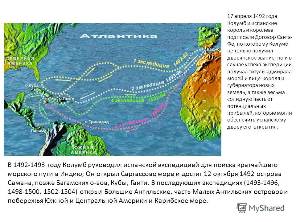
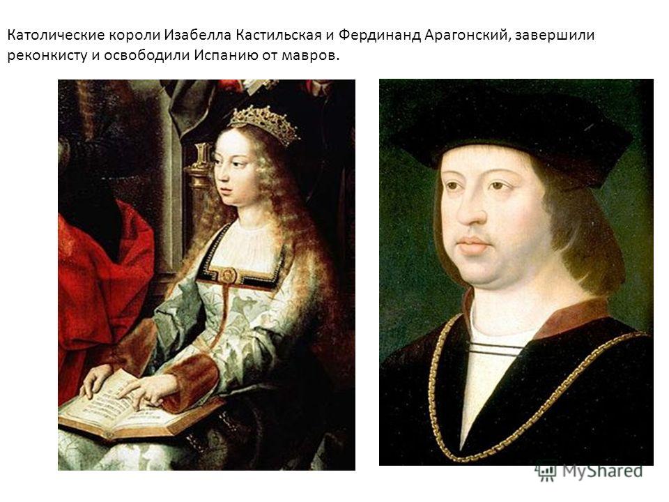
In 1492, Kings Isabella and Ferdinand, who had just completed the reconquest of Spain from the Arabs (Reconquista), sent an expedition under the command of Christopher Columbus to search for the western sea route to India.
Europeans considered India a country of untold riches - gold, precious stones, silk fabrics, etc. Spices and incense brought from these lands were also highly valued. However, to get from Europe to India by land, it was required to go through many countries, to overcome deserts and mountains. It was a difficult and dangerous journey. Therefore, the idea of opening new sea routes to the cherished country seemed very tempting for enterprising European sailors. Among them was Christopher Columbus (1451-1506).
For several years he appealed to the rulers of Portugal and Spain with a request to allocate funds for an expedition to India. Finally, Queen Isabella decided to support the persistent Genoese (Columbus came from this Italian city). Three caravels ("Santa Maria", "Niña" and "Pinta") with a crew of about 100 people were equipped for the expedition.
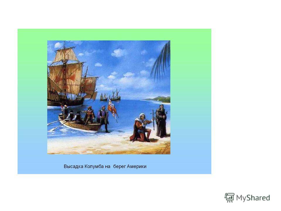
In October 1492, two months after the start of the voyage, Columbus's caravels reached land (the modern island San Salvador and the coast of Cuba and Haiti). The sailors believed that the coast of India was in front of them, and, accordingly, they called the local inhabitants Indians. But it turned out that this was a continent unknown to them, later called America. This is how medieval Europeans discovered the New World. The championship in this belonged to the Spaniards and the Portuguese.
Dates and Events
1492 - the first expedition of Columbus.
1493-1504 - Columbus made three more expeditions to the lands he discovered in Central America.
1497-1498 - opening of the sea route to India by the Portuguese expedition Vasco da Gama.
1519-1522 - first trip around the world Spanish expedition commanded by Fernand Magellan.
These and other events associated with the discovery and development of territories in America, Africa, Asia by Europeans were called the Great Geographical Discoveries. 2.
Peoples of Pre-Columbian America
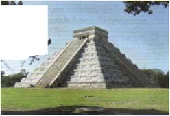
What were the American lands discovered by Columbus and his followers? Who inhabited this part of the continent? The most significant mark in the history of Central America was left by the civilizations of the Maya and Aztecs.
The Mayan civilization dates back to before our era. And in the first millennium AD, on the Yucatan Peninsula, where this people lived, there were several city-states. Most of the population was engaged in agriculture, growing corn, various vegetables, cotton, etc.
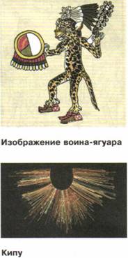
As the finds of modern archaeologists have shown, there were majestic temples and palaces decorated with sculptures and paintings in Mayan cities. The achievements of this civilization make an impression on modern man as well. The Maya were distinguished by deep knowledge of astronomy and mathematics, they used a very accurate solar calendar (the year consisted of 365 days), and had hieroglyphic writing. They deified the forces of nature, worshiped the gods of the sun and moon, fire and rain, as well as gods personified by animals (for example, the jaguar).
Mayan city-states
Territories of states: Г ~~ | Aztecs SHSH Incas
At the end of the X century. Largest cities the Maya were destroyed and abandoned by the inhabitants. Historians suggest various reasons for this - how natural phenomena(earthquake, climate change) and conquest.
The Aztec tribes settled in the XII century. on the territory of modern Mexico. Two centuries later, they created a powerful state with the capital Tenochtitlan. The Aztecs lived in communities in which adult men were farmers and warriors. Captured during frequent campaigns of conquest the prisoners turned into slaves. The supreme power belonged to the leaders (at first they were elected, later the title of the leader began to be inherited). The priests enjoyed great influence. Historians count over a thousand gods in the Aztec pantheon. Religious rituals of the Aztecs were often cruel, they legalized human sacrifice.
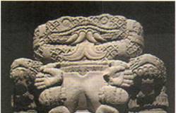
The largest state formation in South America was the Inca power, which took shape in the XII-XIII centuries. centered in the city of Cuzco. At its head was the Great Inca, who was considered the embodiment of God on earth and had unlimited power. The Incas were engaged in agriculture and cattle breeding (they, for example, tamed the llama). They did not know how to produce iron, but they mined and skillfully processed gold and silver. Other crafts also developed - the production of fabrics and ceramics. The Incas did not have a written language, they used the knotted letter kipu (threads of different colors with knots were tied to the cord, the combination of which had a certain meaning). The religious beliefs of the Incas were based on the cult of the Sun.
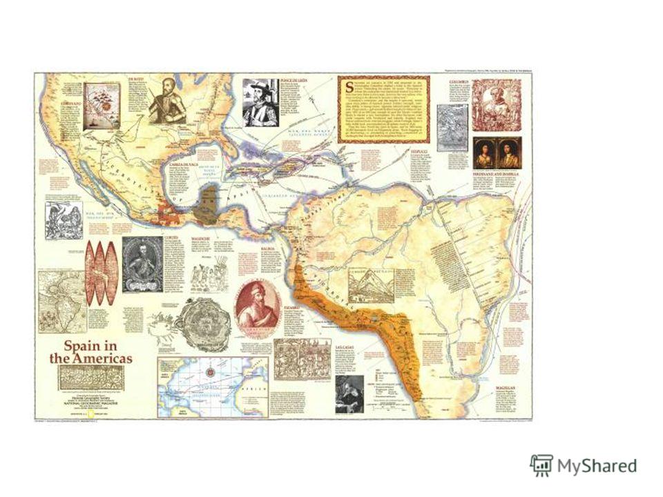
After the discoveries of Columbus and his followers, the conquest of America by Europeans, primarily by the Spaniards and the Portuguese, began.
Christopher Columbus was born in the fall of 1451 in Genoa, Genoese by birth. He was above average height, strong and well built. Reddish hair in his youth turned gray early, which made him look older than his years. On the elongated, wrinkled and weathered face with a beard, vivid blue eyes and an aquiline nose stood out. He was distinguished by faith in divine providence and omens, and at the same time, a rare practicality, morbid pride and suspicion, a passion for gold. He possessed a sharp mind, the gift of persuasion and versatile knowledge. H. Columbus was married twice and had two sons from these marriages. Christopher Columbus spent three quarters of his life sailing.
In the year Columbus led a Spanish expedition to find the shortest sea route to India; He discovered the Sargasso Sea and reached the Samana Island on October 12, 1492, later the Bahamas, Cuba, and Haiti. In subsequent expeditions (,) discovered the Greater Antilles, part of the Lesser Antilles and the coasts of South and Central America and the Caribbean. On April 17, 1492, Columbus and the Spanish king and queen signed the Treaty of Santa Fe, according to which Columbus not only received a title of nobility, but if the expedition succeeded, he received the titles of Admiral of the Seas and Viceroy and Governor of New Lands, as well as a very substantial part of potential profits that could provide the Spanish court with its discovery.
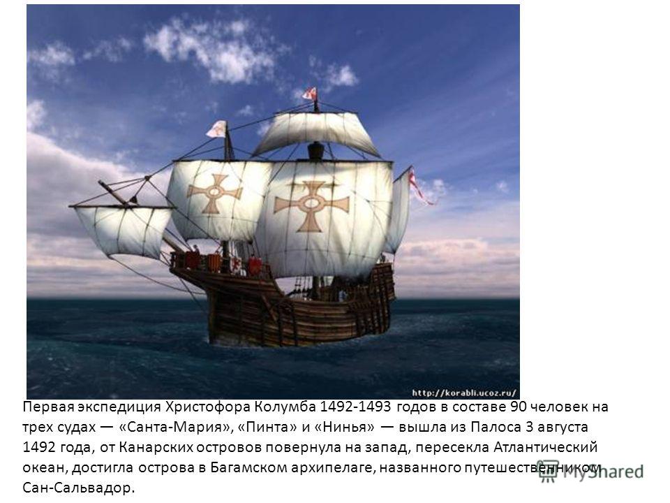
The first expedition of Christopher Columbus of 90 people on three ships "Santa Maria", "Pinta" and "Niña" left Palos on August 3, 1492, from Canary Islands turned west, crossed the Atlantic Ocean, reached an island in the Bahamas archipelago, named San Salvador by the traveler.
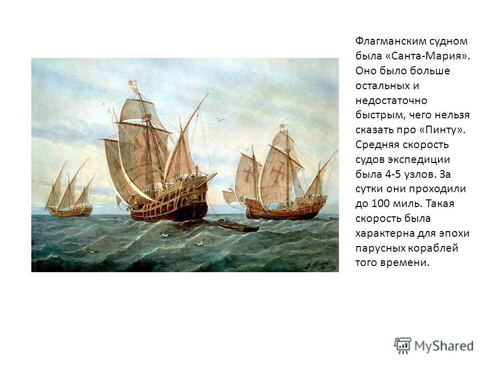
The flagship was the Santa Maria. It was larger than the others and not fast enough, which cannot be said about the Pinto. The average speed of the expedition ships was 4-5 knots. They traveled up to 100 miles per day. This speed was typical for the era sailing ships that time.
On the night of December 25, the flagship Santa Maria landed on the reef, but the crew escaped. For the first time in the history of navigation, by order of Columbus, Indian hammocks were adapted for sailor bunks. Columbus on the "Niña" on March 15, 1499 returned to Castile. The political resonance of the voyage of H. Columbus was the "papal meridian": chapter catholic church established a demarcation line in the Atlantic, indicating to the rivals Spain and Portugal different directions for the discovery of new lands. The second expedition (), led by Admiral Columbus, in the position of viceroy of the newly discovered lands, consisted of 17 ships with a crew of 1.5-2.5 thousand people November 1493 Columbus discovered the islands of Dominica, Guadeloupe and about 20 Lesser Antilles, 19 November Puerto Rico island. In March 1494, in search of gold, he made a military campaign deep into the island of Haiti, in the summer he opened the southeastern and south coast Cuba, Juventud Islands and Jamaica. For 40 days, Columbus explored the southern coast of Haiti, the conquest of which he continued in 1495. But in the spring of 1496 he sailed home, completing his second voyage on June 11 in Castile. Columbus announced the opening of a new route to Asia.
Columbus's third expedition () consisted of six ships, three of which he himself led across the Atlantic. On July 31, 1498, the island of Trinidad was discovered, entered the Gulf of Paria, discovered the mouth of the western branch of the Orinoco delta and the Paria peninsula, marking the beginning of the discovery South America... Having entered the Caribbean Sea, he approached the Araya Peninsula, discovered Margarita Island on August 15 and arrived in Haiti on August 31. In 1500, on the denunciation of Christopher Columbus, he was arrested and shackled (which he then kept all his life) was sent to Castile, where his release awaited. Having obtained permission to continue the search for the western route to India, Columbus on four ships (the fourth expedition) reached Martinique Island on June 15, 1502, on July 30, the Gulf of Honduras, where he first met representatives ancient civilization Maya, but did not attach any importance to it. From August 1, 1502 to May 1, 1503, he discovered 2000 km of the Caribbean coast of Central America (to the Gulf of Uraba). Finding no way to the west, he turned north and on June 25, 1503, it crashed off the coast of Jamaica. Help from Santo Domingo came only a year later. Columbus returned to Castile on November 7, 1504, already seriously ill. Illness, fruitless and painful negotiations with the king for the restoration of rights, lack of money undermined the last forces of Columbus, and on May 20, 1506 he died in Valladolid. Its discoveries were accompanied by the colonization of the lands, the founding of Spanish settlements, the brutal enslavement and mass extermination of the indigenous population called the "Indians" by the conquistadors.
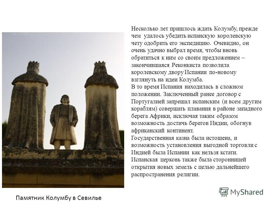
Columbus had to wait several years before he was able to convince the Spanish royal couple to approve his expedition. Obviously, he very well chose the time to turn to them again with his proposal - the ended Reconquista allowed the royal court of Spain to take a fresh look at the ideas of Columbus. At the time, Spain was in a difficult position. An earlier agreement with Portugal prohibited the Spanish (and all other ships) from sailing in the region of the west coast of Africa, thus excluding the possibility of reaching the shores of India by circling the African continent. The state treasury was exhausted, and the possibility of establishing profitable trade with India was very useful for Spain. The Spanish Church was also a supporter of the discovery of new lands in order to further spread the religion. Columbus monument in Seville
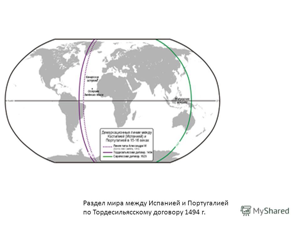
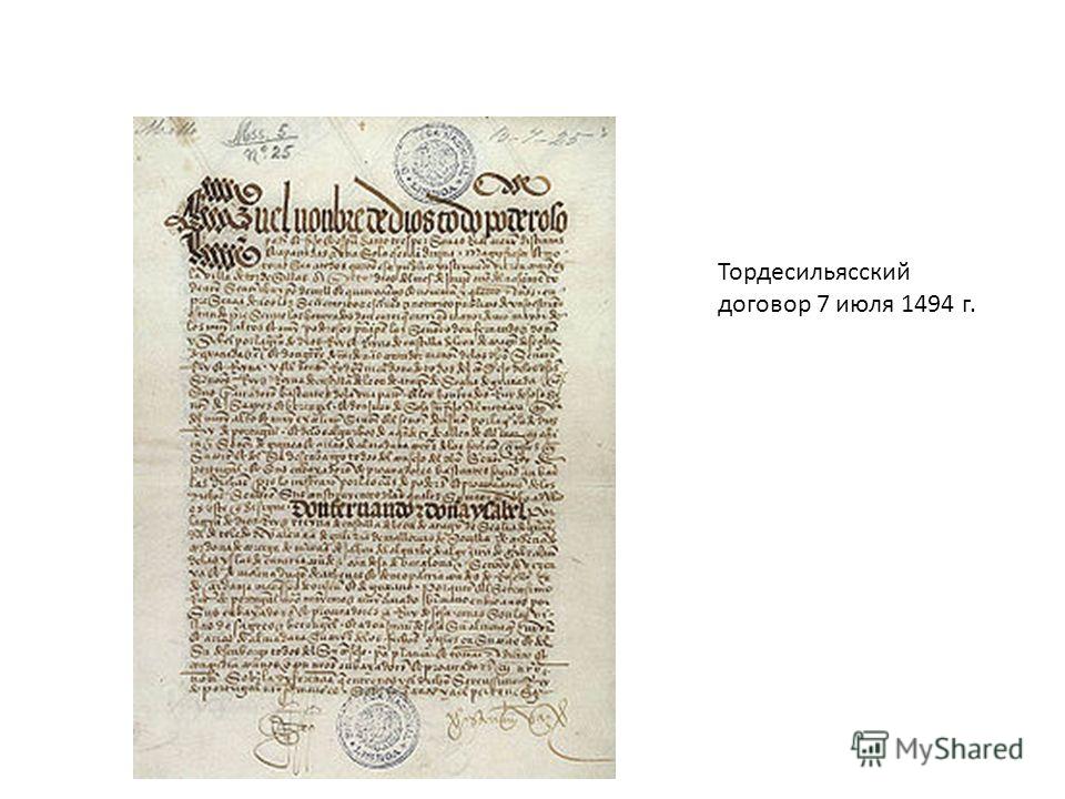
The agreement in Tordesillas was concluded a year after the publication of the bulls on the division of the peace between Spain and Portugal of Pope Alexander VI. In these bulls, the demarcation line dividing the Spanish and Portuguese spheres of overseas expansion was outlined 100 leagues west of the Cape Verde Islands. Thus, Portugal achieved in Tordesillas the transfer of the border 270 leagues to the west. After that, the Portuguese zone included almost the entire Atlantic and a significant part (up to 50 ° West longitude from Greenwich) of Brazil (which was discovered 6 years later by the Portuguese navigator Pedro Alvarez Cabral). At the time of the conclusion of the treaty, Columbus was making his second voyage and was off the coast of Cuba and Jamaica. Castilian representatives suggested that during this journey new lands could be discovered in the eastern part. Atlantic Ocean, and achieved the inclusion in the text of the agreement of a special article on discoveries that can be made before June 20, 1494.
The Tordesillas Treaty provided an unequivocal solution to the problem of dividing the world. The demarcation line was drawn only across the Atlantic. It could not have been otherwise, since only two decades later, sea and land Of the Far East and the Far West became known to Europeans. The inevitable and not foreseen in Tordesillas clash of Spanish and Portuguese interests in Pacific followed during the famous journey of Magellan (). The question of the second demarcation line was resolved only after six years of negotiations by the Treaty of Saragossa of 1529. The Treaty of Tordesillas, like the bulls of Alexander VI, is a diplomatic document of a large historical significance... The treaty laid the foundations of the colonial policy of the Pyrenean powers and clearly formulated the principles of the doctrine of the "closed sea" and the exclusive rights of Spain and Portugal to possession of the entire extra-European world. The articles of the Tordesillas Treaty remained in real force as long as the dominance of Spain and Portugal in the New World, Asia and Africa remained unchallenged.
Already in the 17th century, when the initiative for colonial expansion passes to England, France and Holland, and Spain and Portugal lose a significant part of their West Indies and East Indies in an unbearable struggle, the clauses of the treaty in Tordesillas sound like an anachronism. However, until the end of the 18th century. The Treaty of Tordesillas remained in force in the resolution of border disputes in the South American possessions of Spain and Portugal. West Indies (islands Caribbean) The Spaniards founded the first colonies in Cuba; from 1503 the whole land was divided among the Europeans, and the natives were enslaved and completely died out at the beginning of the 17th century. From the second half of XVI centuries the islands fell into complete decay: not a single foreign European ship could transport goods, the inhabitants themselves had to trade only with Seville, and from 1720 with Cadiz; a large number of colonists moved out, all small coastal cities were destroyed in order to stop the smuggling trade; from 1630 the colonies were plundered by filibusters, who formed a real robber state. With the formation of colonies of other European powers in the West Indies (from the 17th century and especially from the middle of the 18th century), the West Indian colonies began to flourish again. On end of XIX for centuries, all the islands with the exception of Haiti with neighboring small islands (km²) were colonies of European states.
New World the name of America, given to it by European discoverers at the end of the 15th century, opposes America to the Old World to Europe, Asia and Africa due to the fact that Europeans were previously familiar only with the geography of the Old World, but not the New. According to legend, Christopher Columbus believed until the end of his days that he opened a new path to India. But soon the opinion spread that it was not India that was discovered, but a new continent. One of the first supporters of this version was Amerigo Vespucci, whose name the new part of the world acquired. It is believed that the term “ New World"Could have been proposed by the same Vespucci in 1503, but this opinion is disputed. America is the part of the world that unites two continents, North America and South America, as well as nearby islands (including Greenland).

Series "100 Great": One Hundred Great Secrets
Nikolai Nikolaevich Nepomniachtchi
Andrey Yurievich Nizovsky
SECRETS OF HISTORY
FORWARDED COLUMBUS
Humanity recently celebrated the 500th anniversary of the discovery of America by Christopher Columbus. But let's - for the umpteenth time - ask ourselves the question: was Columbus the discoverer of the New World? Of course, one can argue - even if he had predecessors, then what of that? After all, their discoveries did not produce such an effect and did not have such consequences as the voyages of Columbus! Yes, let the Celts, Phoenicians, Normans sailed across the Atlantic, the Chinese went across the Pacific ... But the New World was still undiscovered ...
You cannot say so. And that's why. Numerous "minor" pre-Columbian discoveries of the New World also left a significant mark on history. And the evidence of this is not only the more frequent discoveries of Phoenician and Celtic writings on the rocks in North and South America. (By the way, quite recently, the American scientist J. Savoy discovered samples of Phoenician writing on boulders near the town of Gran Vilaya, 600 kilometers north of Lima, in Peru. And from the Andean peaks, where the village lies, they lead to rivers flowing into the Amazon , ancient stone roads ...)
More significant evidence of contacts has been found by specialists who do not seem to be involved in connections between continents and the mutual influence of cultures. Let us turn at least to the art of encaustics (a special coating made of wax and wood resin), which, it is believed, arose in Ancient egypt for 3-4 millennia BC NS. and flourished in Ancient Greece in the 5th-4th centuries BC NS. At one time, the Russian researcher T. Khvostenko noticed that wax paints were also used in South America and on Easter Island in the Pacific Ocean, and various examples of American encaustics bear the influence of both ancient Egyptian and ancient Greek encaustics. This is stated by a person who is completely uninterested in the victory of this or that grouping - diffusionists or isolationists - supporters and opponents of pre-Columbian contacts! tobacco! After all, traces of tobacco were found in the burial of the pharaohs, but his homeland is Latin America. And eucalyptus oil! The homeland of eucalyptus is Australia, but it got to Egypt long before the beginning of our era.
In short, to the question: "So who discovered America?" - we can state in the affirmative: many were discovered in different eras, and Columbus put the last point in the thousand-year epic of transoceanic voyages to the New World. 498 years ago, the lookout Rodriguez de Trian was the first to see an unknown shore on the horizon. It was tiny Guanajini from the group Bahamas not far from today's Florida. Since then - for five centuries now - there have been disputes on the topic: "Who was the first?" Penetrating deeper and deeper into the wilds of Central and South America, the followers of the Genoese sailor admired the perfect pyramids, crowded cities, majestic stone palaces and could not believe that all this was created by the "servants of the devil", as the first conquistadors dubbed the inhabitants of the New World. The roots of all this had to be searched for in the Old World. Those, the first, researchers could not admit that similar civilizations arose independently in different parts of the world - on the territory of today's Mexico, Guatemala, Middle East, Egypt ...
Scientists came to this idea later, through the centuries, but so far everything, absolutely everything, seems to be explained by the "introduction". By itself, this theory, called "diffusionism", is not devoid of meaning, and we will understand this, getting acquainted with some specific Columbus, but we will not elevate it to absolute. The first in a series of hypotheses about the pre-Columbian discovery and colonization of the New World are the local American versions of the flood, which are quite closely intertwined with the biblical ones. The Maya did have a legend about a terrible flood that destroyed their cities four times. Echoes of this myth can be traced in the drawings of an unknown artist, found in the so-called Dresden Mayan Codex. In fact, there was nothing fantastic in this hypothesis - such motives did not have to be transferred from the Old World to the New: the legends were a reflection of real events, cataclysms that took place millennia BC. Then the Spanish chronicler B. de Las Casas was the first to put forward the version that the “tribes of Israel” moved to the New World after the Assyrians defeated the kingdom of Israel. Casas had a reason for this: elements of early Christianity were found in the Mayan religion and among other ethnic groups of Central America, and it was difficult to dismiss it. In addition, something similar to crosses has long been found in Indian temples.
How can we not recall the famous Paraiba stone from Brazil, which tells about the voyages of immigrants from the Eastern Mediterranean (there is a separate story about it)? Some of our researchers in an ironic style dismissed these versions as "unlikely." But what compelling counterarguments can they put up against the very possibility of ancient Mediterranean people visiting the New World? Only that kulturtragerstvo has long been considered by our ethnographers to be a terrible sin, which it was permissible to blaspheme from all tribunes and in every second book on ethnography. Around 335 BC. NS. the Greek philosopher Aristotle proposed a list of 178 miracles that delight him, relating to all kinds of phenomena in the field of history and knowledge about the world around him. Describing miracle number 84, he notes:
“They say that in the Ocean behind the Pillars of Hercules the Carthaginians found uninhabited island... All kinds of trees grow there, rivers are navigable, there are extraordinary fruits of all sorts; many days' journey to this island ... People should not often visit this island, take possession of the land and take out the wealth of the Carthaginians. "
The traditionally minded archaeologist concludes that this land undoubtedly belongs to England, if Aristotle actually ever wrote "such nonsense" ... We do not think that Aristotle meant England. We believe he was referring to America. He was a responsible scientist, paying attention to details. If he had in mind England, he would have mentioned the uninhabited island as the place where the Carthaginians obtained tin and amber. We also think that he could then indicate it much more accurately. geographic location... But he simply indicates that the island is located at a distance of many days of travel. We talked about this in order to visually trace how differently the facts of ancient history can be interpreted.
In general, the theme of the Atlantic, the legendary islands on it and, in particular, Atlantis as a "staging post", a link between two worlds - the Old and New Worlds - is too vast and mysterious to pass it by, without connecting it with the theme of pre-Columbian contacts. She is still waiting for her researchers with unbiased views. It seems to us that the Austrian ethnographer and linguist D. Welfel, the German ethnographer L. Frobenius and some other scientists and their followers approached the study of the Atlantis phenomenon most seriously. It seems to us that one of the keys to unraveling its secrets and, accordingly, the earliest contacts with the New World lies in the study of the ethnic groups of the so-called White Africa, the territory occupied today by the Great Desert. After all, it is in the legends of the tribes inhabiting, in particular. Moroccan atlas, there are echoes of the legends about Atlantis. One can argue for a long time, forcing the balance to fluctuate in favor of that 304,100 GREAT SECRETS or another version - here everything is complicated by the fact that there are not so many data at the disposal of specialists that would allow putting an end to the disputes. Archeology throws arguments to one side and then to the other.
It is noteworthy that travelers, such as T. Heyerdahl or T. Severin, who simulate ancient voyages, become supporters of the diffusion of cultures, while armchair scientists tend to isolationism. This is symptomatic. Who knows where the new research in the field of pre-Columbian contacts will lead researchers. The long-standing, already traditional dispute on the topic "Who was the first?" ... Most likely, no one. Rather, on the contrary, everyone was the first, because they discovered different parts of the New World for themselves, treated their discoveries differently. And then came the year 1492 - and Columbus appeared, who brought together and used the experience of his predecessors. Who helped him set foot on American soil? In 1477, Columbus traveled north. According to some reports, he was in Iceland. According to others, he was not. He visited Bristol, it has been proven, and we will return to this later. But did Columbus sail further north from Bristol? The famous Canadian polar explorer Williamur Stefansson claims that the winter of 1476-1477 was mild in the polar regions.
The Normans never made a secret of their research in Vinland; all important information was immediately communicated to the Roman Church. Columbus was a devout Catholic, sharing both the missionary ambitions of the church and its progressive geographic views. This can explain why he so persistently persuaded the Genoese and the royal courts of the Atlantic countries to heed his bold statement: there is land beyond the Atlantic and the way to it is a quarter of the distance that pundits assume. In 1473 or 1474, when Columbus began his marine career, times were troubled: the Turks raged in the east, pirates hunted along the Italian coast. Portugal continued to be a great maritime power. Until the end of the XIV century, little was known about it in Europe - the country was turned towards the Atlantic, which was not familiar at that time. By the end of the century, she intercepted the baton of the sea expeditions of the Mediterranean countries. Caravans of slaves began pouring into the markets of Lisbon and Sagres. In 1419, the Portuguese settled in Madeira, a little more than a decade later - in the Azores.
These islands, still uninhabited, but rich in forest and fresh water, lay close to the routes (not yet mastered) that led to the Land of the Setting Sun. Columbus visited Madeira more than once. Until 1872, his house stood in Funchal on Esmeraldo Street, where, according to local legends, he always stayed. In Madeira, Columbus traded in books and maps. In those days, it was no longer difficult to obtain editions of maps of Ptolemy and other scientists, both ancient and modern. The Portuguese years were a time of study for Columbus. True, he himself admitted more than once that he was inexperienced in the sciences. But everything that was necessary for the implementation of his plans, he studied with extraordinary zeal. What are they, these bricks from which the building of his confidence was built? What pushed into the Unknown, into the sea-ocean? The son of Columbus, Fernando, and the chronicler Las Casas, from the words of the navigator, told about what Columbus had heard from the sailors. Someone Martin Vicente told the Genoese that 450 leagues (2,700 kilometers) from Cape San Vicente, he picked up a piece of wood in the sea, skillfully worked with some obviously not iron object. Other sailors met boats with a hut at the latitude of the Azores. We also saw the huge trunks of pines, carried by the westerly wind. They came across the corpses of broad-faced people, clearly not Christian in appearance. So little by little, the huge mainland in the west made itself felt ...
The story of the "unknown helmsman" (the Genoese met him on the island of Madeira in the 80s of the 15th century), who provided Columbus with information about the lands overseas, we found at Las Casas, as well as at Gonzalo Fernandez Oviedo y Valdes in the work " General and natural history of the Indies ": some argue that this captain, helmsman, was an Andalusian; others call him Portuguese, still others call him Basque; some say that Colon was then on the island of Madeira, and some prefer to say that it was on the Cape Verde islands and that it was there that his caravel was carried .. Lisbon is the cradle of the Atlantic navigation of Europeans. It was here that light caravels and heavy "ear redondush" were born, here the Europeans studied sea craft. nautical charts they chopped off their heads, the secrets of discoveries were guarded sternly and vigilantly. Is this not the answer to the question: why was Columbus silent about his conversations with northern sailors? He shore and multiplied these grains of knowledge about the Atlantic and the lands that lay behind it. "In Lisbon, the city where Columbus spent years of study, on the modern Liberty Avenida in a fashionable hotel, the wall of the spacious hall is occupied by a mosaic panel: a bearded" sea wolf "stands on the nose of the caravel and peers into the misty distance. Below the inscription - "João Cortereal. Discoverer of America in 1472." For some mysterious voyages he was given the title of governor of the city of Angra on the Azores island of Terceira.
Let's try to figure out the riddle of Corteral. Documentary evidence of his travel was first clearly stated in a small book by the Danish historian S. Larsen "The Discovery of America 20 Years Before Columbus" Why Danish? What did Denmark have to do with the Portuguese discoveries in the Atlantic? As it turns out, the most direct. It turns out (as evidenced by the manuscripts of the royal archives), King Afonso of Portugal, Has sanctioned the expedition, carried out by two Norwegian captains - Didrik Peining and Hans Poforst. The expedition was accompanied by João Vaz Cortereal, the representative of the King of Portugal. Most likely, it was he who was the head of the enterprise. The first attempts to get Scandinavian sailors into the Portuguese service date back to 1448 - the famous chronicler Gomes Eanish de Azurara wrote about this.He told in detail how a certain Vallart, a Dane, arrived at the court of Infante Enrique (the future Heinrich the Navigator) in Sagres and was appointed the head of the expedition to the Cape Verde Islands. It ended sadly. It is known that Wallart and several other members of the team were captured. local residents and since then they have never been seen again. Larsen cited many such episodes. So, it turns out that relations with Denmark were long and strong.
The death of Heinrich the Navigator did not interrupt these contacts, but only prompted the continuation of the Infanta's plan - the search for a northwestern route across the Atlantic. Here we come to the most mysterious place in our history. King Afonso decided to fund this expedition in the hope that a northern sea route to Asia and India would be found. But there was no known evidence of the possibility of this journey. And then they found a letter from a certain Carsten Krip, burgomaster of Kiel, to King Christian III of Denmark. A letter written on March 3, 1551, states that its author, Carsten Krip, saw a map of Iceland depicting unknown objects found in that country. He further states: the map confirmed that the grandfather of His Royal Majesty, Christian I, sent an expedition at the request of the King of Portugal to the new islands and mainland in the northwest. The recipient's grandfather ruled over Denmark from 1448 to 1481. Is it not about Cortereal in that letter9? The history of Cortereal's expedition to America is full of blank spots for quite understandable reasons: the Portuguese were reluctant to part with their maritime secrets. So, the Danish king sent two - Peining and Pforst. Pining was a pirate, sailed under his own and British flags, and held several important posts in Denmark. He eventually became Governor of Iceland, possibly receiving this position as a reward for his participation in the Corteral expedition. Pforst, a close friend of Pining, was also a pirate.
The starting point of the expedition is unknown, although it is reasonable to assume that its participants left Norway or Denmark and followed to Iceland. From there they went to Greenland and then to the New World. The ship's log was not kept, and it was possible to calculate the course of the expedition with the help of later evidence scattered in various sources. But nevertheless, these testimonies, although they are few, convincingly prove the fact of Corteral's presence in America in 1472. Here is one of them - the famous globe of Martin Beheim in 1492. It picturesquely represents not only the Scandinavian countries, but also the lands to the west of Iceland, which have an amazing resemblance to Nova Scotia, Newfoundland and the Gulf of St. Lawrence Until Beheim, no one made such a globe. But where did he get this information from then? It was possible to find out that Martin Beheim, the famous German astronomer and cartographer, married Joan di Mando in 1486. The beautiful girl was the sister of Cortereal's son-in-law - di Utra, and the newlyweds settled on one of the Azores - Terceira, which was ruled by an elderly Cortereal. Beheim lived there for four years. The globe was made in 1492. This means that for several years Beheim lived in the neighborhood of Corteral and, no doubt, spent a lot of time in conversations with the governor, listening and remembering all the most interesting about the distant seas that he visited in 1472. Comparing Beheim's globe with a later map of the same area, performed by John Cabot, scientists were convinced "the first is better" What if Columbus saw this globe shortly before he went to America?
The fate of Corteral's opening is sad. The expedition was so classified that no one learned anything about the discovery. If the news of the voyage were made public, wouldn't humanity have to celebrate the 500th anniversary of the discovery of America in 1992? A mysterious moment in this expedition remains the treaty between Portugal and Denmark, which gave Christian I the right to all the lands discovered during the search. Perhaps the Portuguese king did not know about the true significance of the discovery of new lands, considered them worthless. But the situation quickly changed when the results of the voyage of Columbus became known.
After 1494, the king twice granted the exclusive right to Gaspar and Miguel Cortereals, sons of Juan, to the "islands and mainland" discovered by their father ... On May 12, 1500, King Manuel signed a deed of dedication, according to which Gaspar Cortereal and his heirs were granted long-term rights to lands, which he "at his own expense and at his own risk intended to rediscover or seek." Note: “rediscovering” clearly indicates that old João Vaz found the land, and that Gasparu intended to find it again and lay claim to it for Portugal! During his third expedition in 1501, Gasparu disappeared without a trace. A year later, Miguel went in search of his brother, and along with the lands he had discovered earlier. And before he went sailing, the king guaranteed him the same rights, indicating that half of the lands found by his brother would become the property of Miguel. Further destiny Miguela Cortereala is also lost in the fog of centuries. At the beginning of our century, a two-volume book by the American Columbus scholar G. Vigno, "The Critical History of Christopher Columbus", was published. It was the first to suggest that Columbus was not going to discover the coast. East Asia, and the islands of the Atlantic, which other sailors already knew about before him. The idea of sailing to the Land of the Great Khan was born, as Vigno suggests, after returning from the first trip. Twenty years later, this theory was supported by the Argentine historian R. Carbia, and later other scientists, including Soviet ones, expressed their support for it. There are counter-arguments, but there are not enough of them to dismiss this hypothesis. What are they?
Credentials to the Great Khan, issued 11 months before Columbus returned from his maiden voyage, - one. The interpreter, who knew oriental languages, attached to the team - two. There are three marks of the sailor in the margins of the books he has read. But was this a planned series of well-conceived fraud? For the sake of what9 Yes, for the sake of at least to hide the true goals of the expedition - to reach the richest land and not share with anyone! Medieval monks were not as stupid as is often taught. They spent ten kilograms of gold for the preparation of the voyage. But count: according to the most conservative estimates, for three hundred years of domination in Latin America Spain exported so many valuables from there that their value corresponded to three million kilograms of gold. There was something to try for. As can be seen from the book of the Irish monk D and Kuila (VIII-IX centuries), the works of ancient authors were read in the monasteries, looking for indications of the distant Happy Islands. Brandana Island travels on medieval maps, on the Venetian portolan (compass map) of 1367 it is in the place of Madeira, and on the Behaim globe - west of the islands Cape Verde. Another mysterious point on the map - the Land of Brazil - was more fortunate, it did not disappear from the maps, like the island of Brandana, but wandered to early XVI century, until it turned into eastern part South American mainland. (By the way, when Pedro Cabral discovered Brazil in 1500, he called it Santa Cruz, and this name was universally recognized by European cartographers in the 16th century. and this is what Dieppe merchants called the ocean lands discovered long before the Portuguese. Another step to Columbus.)
And there was the island of the Seven Cities, and Antilia. These mirages have played a role in the history of geographical discoveries. They seemed to Columbus in the drafting of his project as reliable stages on the way to the west. Or maybe not such mirages? After all, they brought the Spaniards in the 16th century to the hinterland. North America exactly the search for the legendary Seven Cities ... Another striking moment. In the decades preceding the voyages of Columbus, geographical views underwent serious changes, there was, as it were, a transition from correct views to incorrect ones. Amazing transformations are observed on the maps. The countries of East and Southeast Asia are growing exponentially, and they are being moved farther to the east, that is, to the coast Western Europe... Non-existent rivers, mountains, lakes, fantastic countries appear. The cartographers were grounded in practical data - such a conclusion suggests itself. The reasons for the breaking of old views, according to some researchers, are in a number of reports of travelers. And there are many of them. Cartographers were informed about the lands in the west, and they, attributing them to Asia, painted on their portolans. ...
The island of Brasil was also sought after by merchants from Bristol, the fishing center of the North Atlantic. Trading mainly with Ireland, merchants initially did not go to distant seas. But in the 80s of the 15th century, they began to show an increased interest in the fantastic islands in the ocean. Probably not by chance. Apparently the merchants received interesting information from the Icelanders. What European cartographers have long learned about Greenland has already been proven. Claudius Clavus's 1467 map already contains many local names. settlements giant island. At one time, the Spanish historian Luis André Vineras published a letter found in the Simancas archive, shedding light on the history of the discovery of America. In Spanish, without a date, it was written by John Day, an Englishman, to a certain official - the Grand Admiral, who turned out to be none other than the Grand Admiral of Castile, Christopher Columbus. The letter testified to the good geographical knowledge of the sender and proved that the two people were in correspondence, exchanged books and information about the voyages of English sailors. This letter is dedicated to the successful voyage from Bristol of an unknown traveler across the ocean to the country that Day calls the Country of Seven Cities. According to many characteristic data, including the large pension assigned by the king to this man upon his return, it is possible to identify the traveler himself - John Cabot, who in 1497 explored a significant part of Newfoundland and the mainland coast. The letter, however, also says that earlier the traveler made less successful voyages from Bristol. According to Vineras, this was in 1480, 1481 and 1491. Or maybe earlier?
Fobe Taylor, professor at the Institute of Mechanics, an expert in the history of industry and commerce, has discovered new evidence of the sailing of Bristol sailors towards the New World. He came to this after examining detailed commercial records, including customs lists of cargo that each ship had brought into and out of Bristol since 1479. According to the declaration, the captains of the ships were trading with Ireland. However, the often strange composition of cargo and excessively long voyages suggest some kind of mystery. F. Taylor analyzed the nature of the cargo and the voyages of ships. Here is a typical route of one of the ships ("Christopher") that belonged to Morris Targat. He departed from Bristol, ostensibly for Ireland on November 17, 1479, and returned on March 11, 1480, that is, after 115 days. Why was the Christopher's voyage so long? The reason for his delay could not be strong winds in the Bay of Bristol, since other ships made three voyages to the shores of Ireland and vice versa during the same period. It is unlikely that ships went to France or Spain, for such a load - and it was five tons of discarded wine - to be carried there is like sending slag to Newcastle instead of coal. One of two things: either Targat shamelessly squandered time in Ireland, or he drove ships far to the west and carried out his unusual commercial transactions there ...
On June 15, 1480, John Day Jr.'s ship left Bristol and headed towards the island of Brasil, west of Ireland, but returned soon after suffering from bad weather. On July 6, 1481, two ships - "George" and "Trinity" from Bristol, owned by Thomas Croft, left the port to find an island in the ocean called "Brasila". And there were many such voyages. We do not know anything about their results yet. The Spaniard Pedro de Ayala reported from London in 1498 to the royal couple Ferdinand and Isabella: "These from Bristol have been sending every year a flotilla of two, three, four caravels every year in search of the island of Brazil and the Seven Cities ..." sailor in "India"?
Who, knowing or guessing about the untold treasures, supported the seeker of new roads? Columbus was assisted by the Archbishop of Toledo, Cardinal Pedro Gonzalez de Mendoza, the guardian of the king's treasury, Luis de Santangel. They were associated with the merchants and bankers of Castile and Aragon. And to the question: "Who needs it" - they could unambiguously answer: "For us!" The Western route to the East ... Wasn't it the dream of generations of Genoese merchants when the Turks blocked the roads to the Black Sea and captured Constantinople? It was these people who lent money to the Crown of Castile to equip the first and second transatlantic expeditions. It was they who later began to manage trading houses in the colonies of the New World - "Indies". King Ferdinand. In those years he was worried about the problems of Naples and Sicily, Sardinia and Algeria. He extinguished the flames of the peasant war in Catalonia, spent his efforts and resources on Granada. And he gave money for a dubious enterprise! Queen Isabella. She was younger and wiser than her husband. Sweet and courteous with the people she needs. A keen mind and excellent memory allowed her to brilliantly conduct state affairs. Columbus prayed for her all his life. So who benefited from the expedition? Of course, to them, the Catholic kings, who dreamed of a great Castilian-Aragonese empire, owning wonderful cities in China, India ...
Or maybe not India? Who knows what lies beyond the ocean? .. In Columbus's diary, we found there was no hesitation when choosing a route, as well as when moving in a huge, seemingly unknown ocean.
The ships went to the Canaries and from there, at the latitude of these islands, to the New World. That is, along the entire route, they constantly used the blowing east trade winds and favorable currents in the ocean. It was the best sailing route in the Atlantic. D. Tsukernik, a historian from Alma-Ata, notes that, moving along an unknown route, the ships should go only during daylight hours, and at night either stop or slow down in order not to bump into an island or other land. But the caravels were in full swing day and night, as if the helmsman was sure that there were no surprises and there would not be ... Columbus, before leaving the Canary Islands, handed the ship commanders packages, writing on them that they could be opened only in case of separation by a storm. It says, according to Casas, that when the ships are 700 leagues away from the Canary Islands, they do not move at night. 700 leagues is 4150 kilometers. The eastern islands of the Caribbean archipelago are about this distance from the Canary Islands ... How did the admiral know about this?
The problem of returning home faced the members of the expedition in the first days of the voyage. Sea currents and trade winds frightened the crew members. The sailors thought they would be an insurmountable obstacle to their return home. The only person who remained calm and equanimous was Columbus. He reassured the sailors, assuring them that they would also sail back with a fair wind. The flotilla returned to the northeast and for more than two weeks confidently made its way through the winds and waves in this direction. There she fell into the zone of constantly blowing westerly winds and the currents formed by them. Then the ships turned sharply to the east and approached the Azores at high speed. That was best route from the Old World to the New! Columbus's childhood friend and member of his second expedition Michele di Cunes wrote in a letter dated October 15-28, 1495 that when Columbus declared that Cuba was the coast of China, one of the participants in the voyage did not agree with this and most of the satellites did too. Then the admiral resorted to threats and forced the people to take an oath prepared in advance that they agree with him in everything and undertake never to state other views.
So the leaders of the expedition spread false information, as if the open lands were Asia, and the goal of the expedition was only to reach it. Bartholomew Columbus, brother and associate of Christopher, testified: "In those days when the brother interceded for this (about the voyage. - Author), they mocked him, saying that he probably wanted to discover the New World." Neither in the Middle Ages, nor at any other time was Asia ever called that ... We have touched on only a small part of the hypotheses about the pre-Columbian discovery of America - this topic is worthy of a separate book, in which you can talk about Phoenician, Celtic, and African expeditions in New World...