Almost continuous wars in Europe and the established opinion that it is impossible to open Southern mainland and to pass the north-western sea passage were the reason that these tasks were temporarily canceled. However, among some of the scientists, the idea continued to develop that the northwestern passage and Southern land exists.
Russian scientists and navigators were not abandoned by the idea of exploring the northern sea route from the Atlantic to the Pacific Ocean (northwestern and northeastern passages), as well as searching for the southern continent. The study of the first problem was devoted to the voyages of OE Kotseb on the sloop "Rurik", the expedition of MN Vasiliev and GS Shishmarev, the second was solved by FF Bellingshausen and MP Lazarev.
The boats arrived in Persia. But what is this Persia? The continuation of the inscription praises the great king for the success of his company - what? - and we'll just find out that. The inscription of the Suez stele was presented in two versions: one in hieroglyphic, the other in cuneiform, but the two texts are very fragmentary.
11: near the well. We find the same elements as in the previous steles, those that seem to be related to the digging of the channel and those that suggest a hypothetical naval expedition. But this last inscription does not enlighten the other two. The lacunar nature of Egyptian inscriptions and partisan cuneiform documents does not provide grounds for definitive conclusions, and too many questions remain for these Suez stelae, which are considered irrefutable proof of Arabia's journey around the world during Darius.
Otto Evstafievich Kotzebue (1788-1846) made three voyages around the world: the first - as a cadet of the Marine Corps on the ship "Nadezhda" under the command of IF Kruzenshtern in 1803-1806, the second - as the commander of the ship "Rurik" (1815-1818) and the third - on the military sloop "Enterprise" (1823-1826).
O. E. Kotsebue
If the first voyage allowed him to prepare for scientific research and gain experience in maritime affairs, then two other expeditions, which were already led by Kotzebue himself, fell on the heyday of his scientific activity. Kotzebue proved himself to be an outstanding organizer of scientific research and an excellent naval officer.
Kotzebue's voyage on "Rurik" was the fourth round-the-world voyage of Russian sailors and took place shortly after the Patriotic War of 1812. The expedition was undertaken to solve the problem of the northwestern sea passage from the Bering Strait. Its initiator and soul was Kruzenshtern, whose idea was supported by Count N.P. Rumyantsev, who took upon himself all the expenses of the expedition. Kruzenshtern studied the entire previous history of the study of the sea passage from Atlantic Ocean in Tikhiy and convinced Rumyantsev of the advisability of repeating this enterprise. It was decided to equip two ships for the exploration of the northwest passage. One was to leave Russia and sail to the Bering Strait, from where, having rounded North America, it should pass to the east;
Two bays inland to the big sea. Here we come to the proposal of the Arabian Peninsula, seen by the ancients as a triangle bordered by these two inner chasms, but this would be proof that Szilax did not realize his journey of discovery. Indus in Suez, as he apparently did not recognize the southern coast of Arabia. It should be remembered, however, that Scyllax's stories of his journey and India have come down to us only through fragments of Hecatea, rare remains of a work written at least twenty years later by a man who never traveled to these regions.
Another vessel chartered by east coast The United States was supposed to start exploring the "northwest passage" from east to west after the end of the first ship's voyage. Kruzenshtern and Rumyantsev well understood that if the expedition did not solve the main task - opening the way through the northwestern sea passage, then even then it could deliver important information for science and navigation. The mission of the expedition was also to explore the coast North America south and east of the Bering Strait, penetrate the territory of modern Alaska into completely unknown interior regions, explore islands in the central part of the Pacific Ocean. O. E. Kotsebue was appointed as the leader of the expedition, and GS Shishmarev was appointed his assistant. Natural scientists Dr. I. I. Eshsholts and A. L. Shamisso were invited to join the expedition.
Whether it is before or integrated with the conquest of India, the voyage of Scylax could hardly be later than 518 BC, which is usually allowed for the conquest of India by Darius. These two countries appear in the texts only after the exploits of Megabadze in Libya around 510, which apparently confirms that the country of Puta is Libya, and not a traditional stratum, we note a mention in Naqsh-i Rustam, as well as in Suez stelae and statue of Darius in Susa. Hinz proposes another journey of Darius to Egypt on this day, during which the Nile canal would be rebuilt and commemorative steles engraved.
The expedition was equipped with perfect astronomical and physical instruments (masters Troughton, Massey, etc.), the latest editions of maps and atlases (collections of Garsburg, Arrosmith, Purdy, etc.), geographical works. The commander of the ship "Rurik" OE Kotsebue received very detailed "Instructions": on nautical affairs - from IF Kruzenshtern and on scientific observations - from IK Horner.
Therefore, we are faced with two very different events, at least in chronological order. Even if it took two steps, what could Darius have done if he completed the program - community service, reconnaissance, naval expedition - naval link between Suez and Persia? We saw, in the first part of this article, that the commercial interests of the circumnavigation of Arabia were practically zero, the difficulties were so great, it is unclear what products, necessarily weighty, would justify such a course and such risks to go from Egypt to Persia, or vice versa. Shivek offers an explanation: these long journeys were to give Persia a tribute to Ethiopia and Egypt.
IF Kruzenshtern worked at that time on the atlas of the Southern Ocean and, better than anyone else, knew all the dangerous places for navigation, the regions most interesting for research and geographical discoveries. All this was reflected in the instructions. "I wish you to take a completely new course in the South (Pacific - BE) Ocean," he pointed out, "on which it is almost impossible not to make new discoveries." Kotzebue should have paid much attention to checking the dubious discoveries made in different time other navigators: the Dutch (Schouten, Lemaire, Roggevein), the British (Vancouver, Cook, etc.) the French (Bougainville, La Perouse, Florier). Many open lands, especially islands in Pacific did not have exactly specified geographic coordinates or the same islands were plotted on the map at different coordinates and had different names. “It may happen,” I noticed Kruzenshtern, - to Russian it is up to the mariner to decide through his own observations on the spot, whose observations are fairer. "
If we look at the nature of the Egyptian tribute, seven hundred talents of silver and silver. Fishing products from Lake Maurice, in addition to wheat supplies to the Persians in the garrison on site and a two-year gift from the Ethiopians, two ornaments or a brutus. Two hundred ebony balls, five boys and twenty elephant tusks, there is nothing to justify arming a large fleet.
Except for the inclusion of a military escort, they embarked on a long and dangerous adventure, while the land routes are much better equipped and safer. The interpretation of Arabia's circumnavigation of the world as an official route does not seem justified.
Kotzebue was supposed to start researching the coast of North America from Norton Bay and describe not only the coast, but also collect information about the nature and population of the interior of Alaska, its rivers and lakes. The need to describe the coast to the south of the bay up to Unalashka, where no survey had been carried out before that time, was especially pointed out. J. Cook in his last voyage (1776-1779) could not approach the coast in this area due to shallow water. Kotzebue had to do this with the help of a kayak. In winter in the northern hemisphere, the expedition was supposed to explore the tropical Pacific Ocean between the equator and 12 ° N. NS. and 180-225 ° W. at the same time it was emphasized that during the voyage it is necessary to pay attention to the Caroline Islands, which are still very poorly studied; when re-visiting the northwestern coast of North America on canoes, continue exploring Norton Bay and the Bay of Bristol, delve into the mainland, and study it geographically.
It should be added that archeology does not contain any traces of this route, which, however, must necessarily be marked with stops for refueling and, thus, fixed settlements, the coast of the Red Sea is still poorly understood, but no trace of this time has been raised. Having demonstrated that “the inhabitants of the country of Punta are not even mentioned in the documents of the Achaemenid period,” J. The long southern coast of Arabia remains largely unknown and did not provide any information about this period.
In the Arabian Gulf coastal areas Few contemporaries, and such a stop as Bahrain does not yet give undeniable traces of its importance during this period, even if it is certain that the island was inhabited. Arabian-Persian Gulf. These Egyptian or Egyptian sites in Susa seem to result in less international trade asset than the presence of many Egyptians in the city.
Dr. Horner recommended “to carefully observe every extraordinary phenomenon and describe it in detail, especially to measure everything that is subject to measurement.” (Horner's italics). The range of astronomical and physical observations included in Horner's instructions was very wide. coastal inventory and mapping, mountain heights measurement; studies of the inclination of the magnetic needle; observations of the state of the atmosphere (pressure, temperature, winds, etc.) and over phenomena in the ocean (ebb and flow, currents, water temperature on the surface and at depths), determining the depths in the oceans, observing the color and transparency of water, the formation of ice, etc. At the same time, Horner gave methodological instructions and practical advice for the implementation of scientific observations, pointed out the importance that they can have for the development of science. He wrote that " in the sea it happens sometimes as in the atmosphere, the current one above the other, and in different, mostly opposite directions ", and that the study of temperature conditions in the ocean “is extremely important for the general knowledge of the climates of our the globe» .
Ctesias reminds us that Cambyses was the Egyptian king Amirthaus and six thousand of his compatriots exiled to Susa. The destination must be emphasized. If Darius created the Suez Sea Route in Persia, it disappeared with him or his immediate successors.
And we have no compelling reason to question these documents and the facts they mention - and the set of negative presumptions that have just been presented - in both cases, we can provide for isolated and unhindered adventures. Scyllax discovered a sea route that, twenty years later, allowed Darius to send a flotilla to Persia bypassing Arabia. But the difficulties of these trips very quickly prompted the Achaemenids to abandon this path for the benefit of land routes. This quick refusal would also lead to the forgetting of these epics, but exceptional.
Well-written instructions could not, of course, predetermine the results of the research. However, a good organization of the expedition, the experience of its leaders, their own knowledge, an inventive mind and a desire to serve science were the key to the success of the expedition.
Kotzebue expedition headed to Kamchatka past the southern tip South America- Cape Horn. Research began with the launch of the ship in the Atlantic Ocean, but the greatest satisfaction to the sailors was delivered by the discoveries and research in the Pacific Ocean. Trying to accurately fulfill all the points of Krusenstern's instructions, Kotzebue, already at the first stages of his voyage from Chile, determined the position of the island of Sales and undertook a search for the islands seen by Schouten and Lemaire.
Exploration of the Indus and the coast of Baloch and Iran to Oman, as evidenced by fragments of Hecate. The slimes of Suez and the digging of the Nile Canal seem to unequivocally confirm the Achaemenid adventure in the Red Sea: exploration, search for new sea routes? These initiatives of Darius can be explained by the desire of the Achaemenids to establish maritime power. On the other side of the Arabian Peninsula, and without prejudging the details of the conquest of Sindh by Darius, one can only amaze the apparent ease of this expedition closely associated with the voyage of Scyllax, while Cyrus's Indian adventure, a few years ago, ended in disaster on the land routes of Gedrosia.
In the central Pacific Ocean, Kotzebue discovered and explored numerous groups coral islands, undertook a search for the islands previously mentioned by navigators and mapped, determined the coordinates of the previously discovered islands (Palizerovy and Penrin islands). The expedition made significant corrections and additions to the map of the Pacific Ocean. New groups of islands bearing Russian names were marked on it. In 1816, in the northern part of the Tuamotu archipelago, Kotzebue discovered the Rumyantsev (Tikei) and Spiridov (Takapoto) atolls, the Rurik chain (Arutua), the Kruzenstern island (Tikehau) and in the Radak chain (Marshall Islands) - the Kutuzov (Utirik or Betton) islands Suvorov (Taka).
In March 324, Narkus joined Alexander in the Susa region after a long voyage from the mouth of the Indus to lower Mesopotamia along the shores of Gedrosia, Carmania and Persia. The journey of Narkus does not concern us in this conversation, since it connects India with Babylonia and does not concern the Arabian Peninsula. On the other hand, the expedition does not seem to enter the unknown, at least in part. course. "From Carmania, the journey was no longer difficult, and as far as the Persian Gulf was, it was better known."
It is from Gedrosi that Narkus meets competent pilots who assist him in his navigation, and his informants seem to be numerous. Probably Shivek deduces from this that before he left Karachi, Neargus had some stories or notebooks that could lead his expedition; this data, inherited from the Achaemenid period, allowed a reasonable calculation of the risks of the adventure, while the exploration of the Arabian Gulf coast seems to have been a big leap into the unknown.
When exploring the islands, the expedition overcame great difficulties and was exposed to dangers. So, at first two sailors got to the open Rumyantsev atoll, and then with the help of a raft - Kotzebue and other members of the expedition. Usually, travelers walked around the islands (when they could not land) or cross them by land (when they landed and if they were not particularly large).
It contains all the elements of an ethnographic and almost cartographic study of rugged regions, an extensive project that goes far beyond the simple exploration of unknown lands. Again the contrast is good with expeditions along the Arabian coast.
During the return of Narkis, Alexander was preparing for the conquest of Arabia: in the history of Arrian there are enough guesses so as not to doubt the reality of Alexander's plan. The exact motives for this ambitious project, political or commercial and fiscal only, required a preliminary study of the peninsula coasts, clear evidence that any trip around the world Arabia, if it ever happened, has completely disappeared into oblivion. Two series of expeditions took place between 324 and 323, in the Red Sea and the Arab-Persian Gulf, and Arrien's testimony is clear enough to leave little room for interpretation.
The expedition began exploring the North Pacific Ocean in July 1816. Kotzebue passed by Bering Island to the western coast of St. Lawrence Island, and then ascended north to the Bering Strait. He kept closer to the American coast, although he sometimes saw the coast of Asia. Kotzebue wrote about the island of St. Lawrence, which has not yet been visited by any seafarer, Kotzebue wrote: “The seen part of the island (the northern part of the island, where Kotzebue landed] and naturalists. - V.E.) ... consists of rather high ones! snow-covered mountains; there is not a single turf, not even a small shrub, which would adorn the bare cliffs; from time to time small grass only makes its way between the moss and a few lean plants rise from the ground. " Norton Bay Kotzebue decided to describe way back... After passing the latitude of the Cape Prince of Wales, Kotzebue continued describing the American coast. At this time, he saw the islands of Gvozdev (Diomede) and determined the geographical coordinates of some points and clearly saw a vast low-lying island. Continuing further to the northeast, Kotzebue discovered the Shishmareva Bay and a small island in front of it, which he named Sarychev Island. "We were extremely delighted with this discovery," wrote Kotzebue, "for, although it was impossible to expect here a passage to the Arctic Sea, we had the hope of penetrating quite far into the interior of the earth and collecting some important information for us." Exploration of the bay and strait was hampered by many sandbanks and currents, so Kotzebue did not stay here, deciding to conduct an accurate hydrographic inventory next year on canoes (Fig. 5).
Arabian Gulf Coast
This region, in fact, from his point of view, can become as prosperous as Phenicia. All this information was transmitted to Alexander partly by Archiam, who was sent with a ship of thirty oarsmen to investigate coastal navigation towards Arabia and reached the island of Tilos, but he did not dare to continue the investigation, but Androfen, sent with another ship for thirty oarsmen, partly rounded the peninsula of Arabia; it was, however, the pilot Iero de Soles, who advanced farther than all those who were sent on reconnaissance: Alexander also gave a ship to him to thirty oarsmen, and his instructions were what he was to do full turn the peninsula of Arabia to the Arabian Gulf, which bathes Egypt near Heropolis, but he ventured no further, although he toured most of Arabia; he turned and, on his return to Alexander, gave him a report, which said that the greatness of the peninsula was extraordinary and in no way inferior to India; that the peninsula formed a promontory that advanced far into the Great Sea.
Soon, the sailors saw the bay, which was named after the general desire of the team Kotzebue Bay. Individual islands, capes, bays in the bay were also named (Shamisso Island, Eshsholtsa Bay, Cape Deception, Cape Expenberg, Good Hope, M. Kruzenshtern, etc.). Kotzebue Bay and its coastline have been carefully surveyed and documented by travelers. Kotzebue wrote that the bay named after him "should, over time, bring significant benefits to the fur trade, which this country abounds in," and provide a good hiding place for all travelers who might be caught by storms in the Bering Strait. Kotzebue proposed to establish several Russian settlements here. Fossil ice was discovered in the Eshsholts Bay, covered with a cap of earth and overgrown with moss and grasses. “Having removed this sod cover, no more than 1/2 foot of depth, the ground was completely frozen,” wrote Kotzebue. The glacial deposits contained many animal remains and mammoth bones.
Several indications emerge from these texts. There is no doubt that Alexander knew the possibility of joining the Persian Gulf to the Red Sea by coastal navigation, and it was this adventure that he asked his explorers to try.37 This is the first known evidence of an attempt to circumnavigate Arabia from east to west, but it was an unheard of and dangerous adventure. which Alexander could not commit and risk losing important forces: he instructed only one This limitation could only limit the chances of success of the expeditions, and perhaps we should think that after three failures Alexander asked Naryush himself to make this round the world and catch up with Ras Musandam to west, this time with more funds: the day after the fatal banquet in Medios.
The study natural conditions the North American coast, the way of life and customs of the American inhabitants aroused Kotzebue's interest in the opposite, Asian coast. He decided to conduct a comparative study of the coasts of two different continents - America and Asia, separated by the Bering Strait. The expedition headed west and reached the Eastern Cape of Asia (Cape Dezhneva). Kotzebue and naturalists conducted observations on land, met with local population... For the first time, a detailed description of Cape Dezhnev was made.
Pedech, or the vanguard of the conquest of Arabia, since the departure of Alexander himself must follow what is happening with Nearchus? The problem is not a big deal, but the almost hectic nature of the adventures along the coast of the Arabian Gulf should be noted: if the voyage of Narkis was a scientific recognition of a partially known area - a bit like Bonaparte's expedition to Egypt - the navigational works of Archias, Androphenes and Hieron were true exploration of virgin lands. Their reports provide some indications of the size of the Arabian Peninsula: Androfens claims to have "partially bypassed" Arabia, and Hieron "toured most of Arabia."
A comparative study of two isolated regions of Asia and North America allowed Kotzebue to express very interesting and scientifically remarkable ideas: about the geological affinity of the coasts of two continents, about the kinship of peoples living on both coasts.
Observing external structure the coast of Cape Dezhnev, Kotzebue wrote: “This crushing of terrible cliffs makes a person think about the great transformations that once followed in nature here; for the sight and position of the shores give rise to the likelihood that Asia was once united with America; the islands of Gvozdev (Diomida. - VE) are the remnants of the former connection of Cape Vostochny (Cape Dezhnev - VE) with the Cape of the Prince of Wales (of Wales - VE). " He pointed to similar external features local residents Asia and North America and noted: "In general, I find such an insensitive difference between these two peoples that I even tend to consider them descended from one tribe." However, despite the common origin, as was later confirmed, the local inhabitants of North America and Asia were strongly at odds with each other and differed from each other in a number of customs.
From Cape Dezhnev and further south, to Cape St. Lawrence, the expedition carried out a systematic hydrographic inventory of the Asian coast, where new islands were discovered - Khromchenko and Petrov, named after the navigational students of the ship "Rurik" V. Khromchenko and V. Petrov, performed the main hydrological work in the expedition. South of the cape St. Lawrence's inventory was carried out earlier by Sarychev. Kotzebue described the Gulf of St. Lawrence for the second time (Fig. 6).
At the beginning of September 1816, returning to Unalaska, Kotzebue turned to the governor American company with a request to prepare him the necessary equipment (special canoes, etc.) and local residents (Aleuts) for the expedition to describe the western coast of North America north of the Alaska Peninsula next year. From here the expedition headed to San Francisco and then to the Hawaiian Islands. During their stay on the islands, scientists and sailors, taking advantage of the friendly disposition of local residents and the government, visited the hinterland, described a number of harbors and determined the main heights on the islands of Owaigia Muke. The highest was Mount MaunaRoa (2,482.7 ft.) On Owaigi Island. Copebu described in detail the harbor of Ghana Rura (Honolulu) on Wahu Island (Oahu). The Russian people got acquainted with the economy, the cultivation of various cultures on the islands (taro root, bananas, sugar cane, etc.).
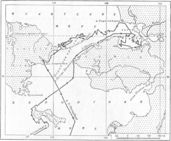
Ryas. 5. Swimming Kotzebue on "Rurik" in the Bering and Chukchi seas
In late 1816 and early 1817, the expedition explored the Marshall Islands. During this time, several inhabited atolls were discovered. Open islands received Russian names: New Year (Medzhit or Miadi), Rumyantseva (Vautier), Chichagova (Erikub or Bishop), Arakcheeva (Caven or Maloelap), Kruzenshtern (Ailuk), etc. Kotsebu called the entire group of islands under study by the native name Radak.
Many of the islands discovered by Kopebu were well known to the locals. The natives quite accurately drew their relative positions on the sand and indicated the direction where the Others were. The natives Kadu and Edoku were of great help to Kotzebue in finding the islands, as well as in drawing up a map of their archipelago of islands. From their words, the Ralik group of islands belonging to the Marshall Islands and located west of the Radak group was mapped. Kotzebue did not have time to examine it, as he had to return to the North Pacific Ocean.

Rice. 6. Map from "Atlas" by G. A. Sarychev (1826), drawn from the map by O. E. Kotsebue
In addition to its practical value, the study of this archipelago was attractive from a scientific point of view. In their structure and origin, these islands were different from many found in the ocean. These were very low islands with unusual ring-shaped outlines, enclosing sea lagoons within them. The communication of the lagoon with the ocean took place by one or several deep narrow channels.
Kotzebue not only discovered and described many of the coral islands, but also explained the nature of their formation. Considerable time was devoted to the exploration of the Rumyantsev (Vautier) atoll. "The vulture islands," wrote Kotzebue, "already arouse great curiosity by their nature, being formed solely by sea animals, and I decided to dare to do everything possible before abandoning my intention to penetrate this chain of islands."
Exploring one island after another, Kotzebue, and especially the naturalists of the expedition Shamisso and Eschsholz, already then came to the correct explanation of their origin, that is, from "sea animals". “Having studied the properties of the soil, we found,” wrote Kotzebue about one of the coral islands, “that this island (Koziy Island - VE), like everyone else, consists of decayed coral; this animal builds its building up from the depths of the sea and dies when it reaches the surface; from this building is formed from the constant washing of it with sea water gray limestone, which, it seems, is the basis of all such islands. " Over time, plants settle on the islands, which then transform the soil and make the soil fertile. By age, as Kotzebue noted, the islands are not the same. They are constantly changing and first acquire a closed ring with a lagoon in the center, and then the lagoons turn into land, forming one large island with a chain.
On the way from the tropical regions of the Pacific Ocean to Unalashka during the storm, "Rurik" was damaged, Kotzebue was seriously injured. However, illness did not stop Kotzebue from intending to go and explore the northern part. Bering Sea... Taking with him the prepared kayaks and Aleut, he left Unalashka to the north. On the way, the islands of Akun and Akutan were described (May 1817), later the seals' rookeries were examined and the coordinates of Bobrovy Island and others were determined. Having reached the island of St. Lawrence, Kotzebue disembarked. Due to Kotzebue's illness, the expedition was forced to abandon further exploration of the northwestern coast of North America and return to its homeland. They returned to St. Petersburg across the Pacific Ocean through the Hawaiian, Marshall, Caroline and Mariana Islands and further around Asia and Africa. Kotzebue explored the Marshall Islands for the third time and on October 23, 1817 discovered the inhabited Heyden Atoll (Likiep), completing the main discovery of the Radak chain. Russian sailors were struck by the lack of people Mariana Islands, during the time of Magellan, densely populated. The entire indigenous population of the islands was exterminated by the Spanish colonialists. “The sight of this beautiful land gave birth to me,” wrote Kotzebue, “sorrowful feelings; in former times these fertile valleys served as a dwelling place for a people who spent their days in silence and happiness; now only lovely palm forests stood here and overshadowed the graves of the former inhabitants. Mortal silence reigned everywhere. " Almost the entire chain of the Mariana Islands was uninhabited, only a few were inhabited by settlers from Mexico and the Philippine Islands.
During the voyage, the Kotzebue expedition carried out meteorological and oceanographic observations. Measurements of the sea depths were widely carried out using a specially designed device, the water temperature at depth was measured, soil samples were taken and sea water... In 1815, Kotzebue made several measurements of the depth in the Atlantic Ocean (up to 138 fathoms), the next year in the Pacific Ocean, the lot dropped to a depth of 300 fathoms. The transparency of the water was noted using a simple method - lowering a white plate, which later formed the basis of an instrument for determining the transparency of seawater and called the Secchi disk. Transparency was uneven and ranged from 2 to 13 fathoms. On September 4, 1817, Kotzebue reached a record depth when measuring the temperature of sea water in the Pacific Ocean, at a point with coordinates 35 ° 51 "N and 147 ° 38" W. The village of Lotlin sank to a depth of 408 fathoms, and seven intermediate observations were made. The ocean surface temperature was + 72 ° F, and at extreme depth - + 42 ° F. The transparency of the water was 11 fathoms. When the thermometer was lowered to a depth of 500 fathoms, the cable broke and the experiment failed. September 26, 1817 measured the temperature of seawater at 12 points at different depths.
Returning to Russia, Kotzebue and his companions-scientists undertook work to summarize the materials of the expedition. In 1822-1823. the essay "Journey to the Southern Ocean and the Bering Strait ..." was published. Three books of work covered the preparation and course of the expedition, the results of the research. The work contained: Kotzebue's report on the expedition (parts I-II), articles by Krusenstern (parts I-II), articles by I. Horner, A. Shamisso, I. Eschsholz and M. Engelgart (part III).
IF Kruzenshtern in the article "Consideration of the discoveries made in the Great Ocean from the ship" Rurik "", summed up geographical discoveries Kotzebue and gave them a fair assessment. Oi noted the outstanding significance of discoveries for science and navigation, compared what Kotzebue had made with the achievements of the largest European navigators, such as Cook, Bougainville and Flinders. He exposed the attacks and mistrust of Kotzebue's discoveries on the part of some European scientists.
Kotzebue not only made extremely important discoveries, but also "closed" many problematic discoveries of earlier navigators (in the central part of the Pacific Ocean), examined and described groups of islands, the information about which was rather approximate. So, for example, the Penrin Islands, discovered in 1788, were taken by the British for one island. Russian sailors counted 15 islands. Kotzebue was the first to accurately determine their latitude (9 ° 1 "30" N) and longitude (157 ° 34 "32" W). Kotzebue discovered six groups of islands, collectively named by him Radak, and indicated the location and names of islands in the neighboring Ralik archipelago.
Atlas, compiled by Kotzebue, contained plans and maps of marked and described places, coasts and harbors. It was widely used both in navigation and for the compilation of special nautical atlases.
As a result of the voyage of Kotzebue, a description of the nature of the coral islands of the Pacific was given and the hypothesis about their origin was most clearly expressed. Charles Darwin has repeatedly pointed to this. In a study devoted specifically to this issue, in 1842, he wrote: “An older and more satisfactory theory (of the origin of coral islands - V. Ye.) Was proposed by Chamisso: he believes that since more massive coral species prefer surf, the outer parts of the reef are the first to reach the surface and therefore form a ring. " A more detailed examination of the structure of coral islands and an explanation of their genesis was made by II Eshsholts in his special article "On coral islands" (Fig. 7). “The low-lying islands of the South and Indian Seas,” he wrote, “owe much of their origin to the industrious construction of various genera of corals ... corals based their buildings on the shoals of the sea, or rather, on the tops of the mountains underwater. Continuing their growth, they, on the one hand, continually approach the surface of the sea more and more, and on the other, spread the vastness of their structure ("Journey to the Southern Ocean ...", Part III, p. 381). When the island reaches the surface, the animal dies. Shells, molluscs, and physical weathering are involved in the transformation of the solid surface. Then plants and birds appear, for which a person comes. This is, in general terms, the picture of the formation and settlement of coral islands, according to the ideas of Russian scientists of that time.
CIRCULAR SWIMMING OE KOTSEBU AND THEIR SIGNIFICANCE FOR GEOGRAPHICAL SCIENCE. Part 2
Later, the theory of the formation of coral reefs underwent changes and found its development in the works of Ch. Darwin, who, as L. Sh. Davitashvili wrote, “gave a true theory of coral reefs”. Darwin associated the origin of coral islands with regional fluctuations of the ocean floor, i.e., its slow subsidence.The collection of minerals collected by the Kotzebue expedition on the shores of California, Unalaske Island and the coast of the Bering Strait was processed by M. Engelgart. In the article, the author expressed interesting considerations about the similarities between Kamchatka and the Aleutian Islands and Unalashka, Asia, and North America: ocean ... ", part III, p. 391). Engelgart also rightly pointed out that in geology - "the organization of the earth" - "one must look for a reliable foundation for physical geography" (ibid., Part III, p. 393).
I. Horner processed meteorological and oceanographic data. He made a number of significant conclusions following from the observations, and advocated a systematic study of the temperature of sea water at a depth according to the established scale (25, 50, 100, 200 fathoms). He considered such observations to be an important section in the development of the doctrine of "heat in general, and especially to the dissemination of the physical description of the globe" (Part III, p. 435) and understood that it was impossible to draw any definite conclusions from scattered testimonies.
Very interesting ideas about the formation of climate in Europe, in connection with the study of the influence on the climate of the oceans and seas, expressed in this work A. Chamisso. The author develops a theory about a twofold tendency of the atmosphere: from the equator to the poles in its upper layer and from the poles to the equator in the lower one. Considering the movement of the Earth around its axis, he believed that air masses coming to Europe from the central regions of Africa, brought heat and intensified the continentality of the climate, and, conversely, sea spaces in the same latitudes tempered it. “It seems to us,” he wrote, “that in the solid earth lying to the south and south-west of Europe between the equator and the northern turning circle, there is a kind of furnace that warms the air passing through it and serves as the basis for its climate; an oven that no other country uses; and we believe that, in general, the hardened land lying between the equator and the turning circles should provide the strips of land further east to the poles with a much warmer climate against the one that prevails in other strips of land under the influence of the seas lying in the same direction. ".
Rice. 7. The first page of the article "About the coral islands" in the essay of Kotzebue "Travel ..."
This theory of ascending and descending air currents in the Earth's atmosphere, expressed earlier, was confirmed by subsequent studies and became of paramount importance for assessing and characterizing atmospheric processes and climates on Earth.
In 1823-1826. on the recommendation of Krusenstern, Kotzebue makes the third round the world trip on the ship "Enterprise". The expedition was ordered to deliver naval equipment and food to Kamchatka, and then carry the guard of the North American colonies for a year. The team included young scientists V. Preis (astronomer), E. Lenz (physicist) and E. Hoffmann (mineralogist). Natural scientific observations were also carried out by Dr. I. Eshsholts, who sailed on the "Rurik". Krusenstern worked out instructions for Kotzebue, and Preis, Lenz and Hoffmann were presented with "excellent rules" for scientific observations, compiled by professors V. Ya. Struve, EI Parrot and M. Engelgart.
Kotzebue was allowed to conduct scientific observations along the way and after another warship came to America to replace him. This time, Kotzebue chose the Tuamotu archipelago and the northern part of the Marshall Islands as the main area of study. As a result of the voyage, he discovered and described a number of new islands: Enterprise - Fangakhina (15 ° 58 "18" S and 140 ° 11 "30" W), Bellingshausen - Motuoni (15 ° 40 "11" S lat. and 154 ° 30 "00" W), Eshsholtsa - Bikini (11 ° 40 "11 N and 194 ° 37" 35 "W), etc. The islands of Otaiti ( Tahiti), Navigators (Samoa), the Radak chain of islands; on the way back from Kamchatka - the Pescadores, Mariana and Philippine Islands (Fig. 8) This expedition was less significant in its results than the previous one, but had great merits in scientific research of the atmosphere and oceans, and it pioneered accurate, systematic meteorological and oceanographic observations.
The first observations of water temperature at depths were carried out in the central part of the Atlantic Ocean. A specially designed bottle was lowered even to a depth of 1000 fathoms, but the cable could not withstand the load and broke off. We continued to conduct observations with the help of a second, spare cable and a device. In the Pacific Ocean, in the area of the Marshall Islands, Lenz lowered the bottle several times to 800 fathoms, and on the way from here to Kamchatka, it was possible to observe the temperature of sea water at a depth of 1000 fathoms. All research on the ship was carried out with the direct participation and iodine of the leadership of Kotzebue.
Scientific research, especially the study of new discovered lands and their inhabitants, brought him real pleasure. Kotzebue admitted this himself when he wrote: “Being on the high seas, I was always happy about the appearance of land. True, I was also not uninterested in sailing a ship to distant seas and fighting against a changeable element. But what really fascinated me was the acquaintance with new countries and their inhabitants. It was here that I received a reward for the difficulties of the path. " Kotzebue infected all his officers and even sailors with this property. Naturalists often penetrated into the inner parts of tropical islands, climbed mountains, where no man's foot had gone. The relief, geological structure and mineralogical composition of the islands, their internal waters, soil and vegetation cover were studied. When visiting the islands of Otaiti (Tahiti), Hoffmann undertook an ascent to mountain lake, on which none of the Europeans have been and sang the measurements of its depth. According to Hoffmann's observations, the lake was at an altitude of 1,450 feet and was 11 fathoms deep at the shore and 17 fathoms in the middle. The most high peak on the island of Tahiti, determined by Lenz's barometric method, was 8 thousand feet (2438.6 m).
On the basis of new observations of Kotzebue, the previously stated hypothesis about the formation of coral islands and their genesis was confirmed. “It is interesting,” he wrote about the origin of the island of Guaham (Guam), “that on Guaham, under a layer of black earth, there are coral massifs that are only partially weathered. This circumstance allows us to assume that there was once a group of low-lying coral islands, which, under the influence of volcanic forces, was lifted upward along with its lagoon, forming the present island of Guaham. " When inspecting the island, Hoffmann discovered a volcanic crater. Kotzebue develops the theory of the formation of soil (chernozem) for a long time from the vegetation cover and under the influence of other factors (weathering, the action of water, etc.).
The expedition described the islands of the Navigators (Samoa), examining them southern part, and thus completed the survey of the entire archipelago, Kotzebue considered them the most beautiful in the Pacific Ocean and in the whole world. The coordinates of some of the islands in the Society's archipelago were refined and small uninhabited coral islands were discovered. Kotzebue compiled a mercatorial map of the northern part of the Caroline Islands, Radak and Ralik. Extensive observations were made in Kamchatka and in Russian America. Hoffman, Lenz and other members of the expedition traveled to Avachinskaya Sopka and found its height equal to 7200 feet (2193.56 m) above sea level (according to the present data, 2738 m); Preuss observed a solar eclipse on July 14, 1824. On the basis of these measurements, he calculated more accurately the longitude of Petropavlovsk (158 ° 49 "29" E). As a result of the observations, as well as materials from previous studies, Kotzebue gave an excellent geographical description Kamchatka. In its artistic skill, it can be compared with the descriptions of Golovnin. Kamchatka, in his opinion, has great prospects for its development. “There is no doubt,” he wrote, “that here are hidden numerous treasures that will someday be found and put in the service of man”.
Kotzebue noticed a difference in the climates of the northwest coast of America, Europe and Of the Far East... He pointed out that the climate of the American coast is much milder than that of the Asian coast. “This area,” he noted, “is located at 57 ° N. sh., generally differs in a milder climate than the same sprats of Europe, while the northeastern coast of Asia is much colder than the European countries corresponding to it in latitude. " Kotzebue corrected the Vancouver map showing West Coast North America, 20 "east of its actual position. The resulting coastline image was more accurate as the inventory was taken from an anchored ship, while Vancouver was observing from a moving ship.
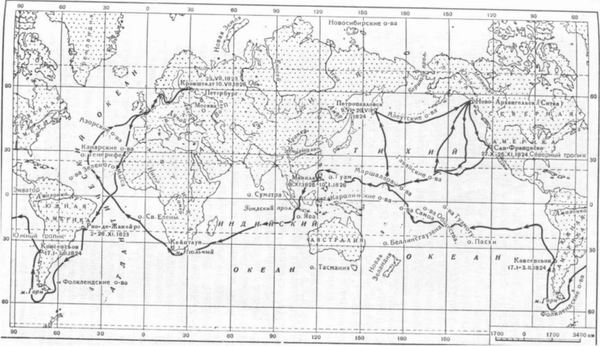
Rice. 8. Route of the circumnavigation of the world by O. E. Kotsebue on the sloop "Enterprise" (1813-1826)
Big scientific significance had ethnographic observations and descriptions of Kotzebue of various nationalities and tribes, as well as their economy.
The results of the voyage of Kotzebue on the ship "Enterprise" in 1823-1826. were summarized in his works "Travel around the world, accomplished at the behest of the State. Imp. Alexander I on a military sloop "Enterprise" in 1823, 24, 25 and 26, under the command of the fleet, Lieutenant-Commander Kotzebue "(St. Petersburg, 1828) and" A New Journey Around the World in 1823-1826. " ...
An important contribution to science was represented by the works of the participants in the last circumnavigation of the world Kotzebue E. H. Lenz and E. K. Hoffmann. Generalization of the research carried out onboard the ship "Enterprise" on physical oceanography opened the way for the scientific activities of E. Kh. Lenz at the St. Petersburg Academy of Sciences. When he was elected an adjunct (1828), he read a lecture "On the salinity of sea water and its temperature in the oceans on the surface and in the depths." In 1831 Lenz published an extensive work in which he developed the issues raised in the report and summed up the work carried out during his circumnavigation of the world. It contains observational data on salinity and water temperature in the ocean on the surface and in depth (up to 2 thousand meters), barometric observations, comparative tables of air and ocean water temperatures.
It should be noted that observations of the temperature of the water in the ocean, the determination of depths were carried out with instruments invented by Lenz himself with the participation of prof. E. I. Parrot. With the help of a bottle, a high accuracy of observations of the water temperature at a depth was provided and water samples were taken to determine its specific gravity (and, consequently, salinity). The depth measurement was carried out with a depth gauge - a view with an automatic brake. Based on these observations, Lenz subsequently made important conclusions about deep oceanic circulation that anticipated modern concepts in this area.
Lenz continued to work on questions of oceanography later, although physics became his main field of study. On November 26, 1858, he read a report at the Academy of Sciences on the measurement of sea and air temperature over the tropics.
The works of Kotzebue and Lenz were highly appreciated by Russian scientists such as S.O. Makarov, Yu.M. Shokalsky, N.N. Zubov. S.O. Makarov ranked individual observations carried out at the "Enterprise" higher than the observations carried out by the British expedition on the Challenger ship (1872-1876), and even his own on the Vityaz ship. Yu. M. Shokalsky wrote with good reason that “the works of Kotzebue and Lenz in 1823-1826. represent in many respects not only an important contribution to science, but also the real beginning of accurate observations in oceanography, which the Russian Navy and Russian science can be proud of. "