The climate of Moscow is moderately continental, but the degree of its continentality relative to other large European cities is much higher. Annual amplitude has in Moscow the highest value of 28 ° C (in Paris 16 ° C, Berlin 19 ° C, Warsaw 22 ° C). The average long-term and extreme air temperature is given in table. 1.
Tab. 1. Average long-term and extreme air temperature
Frost starts on average on September 29, ends around May 10; the frost-free period is 141 days, its extreme limits are 98 and 182 days. The duration of the growing season (with an average daily temperature of 3-5 ° C) is 175 days (from April 18 to October 11). Persistent frosts on average from November 24 to March 10. Thaws in January and February last for 5-7 days, in December for 8-9 days, in November and March for 17-18 days. Hot weather with temperatures> 25 ° С occurs on average about 30 days a year. The hottest July with average temperature 23.3 ° С was observed in 1938, July 1972 was not much different from it, memorable not only for the heat, but also for the severe drought. For the three summer months of 1972, there were 63 days with temperatures above 25 ° C (of which 23 days with temperatures above 30 ° C; at a rate of 28 and 6 days, respectively). The deficit of precipitation during this summer was more than 90 mm, July was especially dry, when 38% of the precipitation norm fell. Forests and peat bogs burned in the Moscow region. An equally significant (less than 90 mm) deficit of summer precipitation was observed in Moscow in 1885, 1891, 1897, 1917, 1938, 1939, 1955 and 1964. The coldest July was in 1904 and 1912 - 14.6 ° C and 14.7, respectively. ° C. In January 1893, the average monthly temperature was -21.6 ° C, that is, it was about the same as on Novaya Zemlya. With a steady flow of air from the side Atlantic Ocean the number of thaws can reach 1/3 of all winter days, as, for example, in winter 1960-61. In such years (for example, 1944, 1949, 1971), the average January temperature can be higher than -4 ° C (-3.7, -3.8 C).
Usually 540-650 mm of precipitation falls per year. The rainiest was 1952 (819 mm), the driest 1920 (354 mm). On average, there are 184 days per year with precipitation of 0.1 mm. Average precipitation, relative humidity and sunshine hours are given in table. 2.
Tab. 2. Average long-term precipitation, relative humidity and sunshine hours
The highest daily rainfall was observed in July 1953 (61 mm). The thunderstorm season lasts from April to October, when on average there are 23-27 days with a thunderstorm, and in the most thunderstorm month of July, 7-8 days. In some years, the number of thunderstorms reaches 35-40, in July up to 12-14. Occasionally they occur during the winter months.
A stable snow cover sets in around November 26 (deadlines October 31 and January 9) and finally melts by April 11 (deadlines March 23 and April 27). The height of the snow cover by the end of winter reaches an average of 30-35 cm.
The degree of sky coverage with clouds is determined on a 10-point scale, and there are 3 main states of the sky: clear (0-2 points), semi-clear (3-7 points) and cloudy (8-10 points). The largest number of clouds in Moscow is observed from October to January, when the frequency of the cloudy sky is on average 75-85% for the total cloud cover and 65-75% for the lower cloud cover. This is caused by the highest intensity of cyclonic circulation in autumn and in the first half of winter. In the warm period of the year (April - September), the frequency of the cloudy sky decreases to 48-60% for the total and 30-45% for the lower cloudiness. Sometimes low clouds are perceived as fog, for example, when they cover the tops of high-rise buildings. For example, in the area of Moscow State University, such cloudiness can appear to the observer as fog, while from the side Kievsky railway station only low clouds are visible. Fogs are observed on average for 31 days a year, of which 20 occur in the period from October to March. They are distributed unevenly throughout the city: the least of them is in the center (20 days), where there is less evaporation due to a well-developed sewerage network that quickly passes rainwater; most of all in the South-West (up to 45 days).
The annual pressure variation is insignificant: the average monthly pressure values from October to February remain almost unchanged and amount to 748 mm, in the summer months (June - August) - 746 mm. However, in some cases, during the passage of deep cyclones and powerful anticyclones, the pressure can vary within significant limits and the amplitude of its fluctuations in winter reaches 71 mm: the lowest pressure of 710 mm was observed in February. 1958, the highest 781 mm - in December. 1944. In summer, the amplitude is 41 mm: the lowest pressure 720 mm was recorded in June 1947, the highest 761 mm - in August 1944. At the same time, with the rapid passage of deep cyclones, the pressure during one day in winter can change up to 20-24 mm, in summer it is somewhat less.
Winds in Moscow all directions are possible, but in warm weather the north-west prevails, and in the cold - south-west. On average, it happens up to 16 days per year with strong wind> 15 m / s. Hurricane winds are possible once every 10-15 years.
The natural course of temperature, the distribution of precipitation, humidity, sunshine and other meteorological factors change significantly due to a sharp increase in the area of urban buildings. This is primarily due to the huge number of stone structures, large area iron roofs, asphalt pavements, industrial waste. Arising above big city The “island” of warmth is very distinctly expressed in Moscow. As a result, the temperature in the city as a whole is 1.5-2 ° C higher than in the surrounding area, which, as it were, displaces Moscow by 150-200 km to the south. The city center is warmer than the outskirts throughout the year by an average of 1-2 ° C. In the cold season, especially at night and with a cloudless sky, the temperature difference between the center and, for example, the VDNKh region can reach 10 ° C or more. Frosts in the city center start 2 weeks later and end by the same amount earlier, so the frost-free period in the center is a whole month longer than in the outskirts. Heavy rains in the center fall almost 1.5 times more often than on the outskirts and outside the city, and Eastern Moscow is rainier than western Moscow by 50 mm per year. In the center of Moscow there is 100 hours of sunshine less than in the outskirts.
The city's climate is also affected by the general warming process, which is significantly higher than the changes caused by urbanization.
(Moscow. Encyclopedia, 1980)
Annual precipitation... The formation of precipitation and their amount in any territory depends on three main conditions: the moisture content of the air mass, its temperature and the possibility of ascent. These factors, acting together, create a rather complex picture of the geographical distribution of precipitation.
On the territory of the Russian Plain, the greatest amount of precipitation (600-700 mm / year) falls in the zone of 50-65 °, s. NS. In these latitudes, cyclonic processes are actively developing throughout the year, and the largest amount of moisture is transferred from the Atlantic. In addition, the presence of a chain of uplands (Central Russian, Smolensk-Moscow, Valdai, Northern Uvaly) contributes to an increase in precipitation. To the north and south of this zone, the amount of precipitation is gradually decreasing. On Kola Peninsula, in the Arkhangelsk region, the Komi Republic and the Republic of Karelia the annual precipitation is 400–550 mm / year. On the Arctic coast, it decreases to 350–370 mm / year. The “islands” of increased precipitation in the north of the European part of Russia are the Khibiny (800–1000 mm / year) and the Timan Ridge (600–630 mm / year). South of the zone of increased precipitation, i.e. south of 50 ° N. sh., a decrease in precipitation from the northwest to the southeast is clearly traced. While on the Oka-Don Plain the annual precipitation is 520–580 mm / year, in the lower reaches of the Volga it decreases to 200–350 mm / year.
Ural, separating Russian and West Siberian Plain, creates a meridionally elongated strip of increased amounts of precipitation on the leeward side and at the top of the ridge. In the Northern Urals precipitation is 800–900 mm / year, in the Middle and Southern Urals - 600–700 mm / year. At some distance behind the ridge there is a strip of less precipitation.
Similar to the latitudinal distribution of precipitation in the Russian Plain, in the territory Western Siberia at latitudes 60–65 ° N there is a zone of increased precipitation. However, it is narrower than in the European part of Russia and less precipitation falls here, since air currents from the Atlantic lose part of their moisture over the Urals. In the middle reaches of the Ob River, in the Khanty-Mansiysk region, the annual precipitation is 550–600 mm / year. To the south and north of this strip, the amount of precipitation decreases. On the Arctic coast of Western Siberia, annual precipitation does not exceed 300–350 mm / year. Almost the same amount of precipitation falls in the south of Western Siberia. However, in comparison with the Russian Plain, the area of low precipitation amounts here is significantly shifted to the north. At the same latitude (55 ° N), 690 mm of precipitation falls per year in Smolensk, while in Omsk it is almost two times less - 368 mm / year.
On the territory of the Central Siberian Plateau, a gradual decrease in precipitation from west to east is observed. The greatest amount of precipitation here falls on the Putorana plateau and on the Yenisei Ridge (500–600 mm / year). To the east, including the Lena River valley and the lower reaches of the Aldan River, the amount of precipitation decreases markedly, especially during the cold season. In a vast basin located in the center of the Central Yakutsk lowland, closed by the plateau from westerly winds, precipitation is only 250–300 mm / year, which is typical for steppe and semi-desert regions. A decrease in precipitation is also traced to the south, up to Transbaikalia. Sayans, the mountains of the Baikal region and, partly, Transbaikalia are quite intensively moistened by precipitation from air masses coming from the water area The Pacific especially in summer and autumn. Annual precipitation here is 500–550 mm. In northeastern Siberia, the alternation of mountain ranges, plateaus, intermontane basins and lowlands creates an extremely variegated picture of the distribution of precipitation. The greatest amount of precipitation in this area falls on the western slopes of the Verkhoyansk ridge (350–450 mm / year). In the area of the Kolyma Lowland and on the coasts of the East Siberian, annual precipitation does not exceed 200–250 mm. The intermontane basins separating the Verkhoyansk ridge, the Chersky ridge and the Momsky ridge are also very dry.
Further to the east, as we approach the marginal seas of the Pacific Ocean, the annual amount of precipitation increases. In winter, dry and cold continental air masses dominate the mainland, and humid Pacific air in summer. temperate latitudes... The minimum amount of precipitation in this area (200–250 mm / year) is observed on the coast. On the coasts of Beringovo, the annual precipitation also increases to 550–600 mm / year. However, it should be noted that here, even at a short distance, the amount of precipitation can vary significantly. On the eastern slopes of the coastal ridges, which are windward for the wet summer monsoon (Dzhugdzhur, Kolymsky, Koryaksky ridges), the amount of precipitation is 600-700 mm / year. Their western slopes are less humid, where the annual precipitation does not exceed 300–400 mm. On the eastern slopes of the Bureinsky ridge, 750-850 mm of precipitation falls per year. To the west, in the valley of the Zeya River, where the influence of the summer monsoon is already less noticeable, the annual precipitation gradually decreases to 550–650 mm / year. In the Primorsky Territory, the Sikhote-Alin ridge has a decisive influence on the geographical distribution of precipitation. In this region, the most intense precipitation falls on the coast and slopes of the Sikhote-Alin (850-950 mm / year). A large amount of precipitation is brought here in summer by frequent southern cyclones and. In the central part of the Sikhote-Alin, in closed valleys and basins, the amount of precipitation decreases by 150-200 mm / year in relation to the open peaks and slopes. In the direction of Lake Khanka, the amount of precipitation decreases to 550–600 mm / year. Private cyclones, high moisture content of the air and the mountainous terrain of Sakhalin and the Kuril Islands make this region one of the most humid in Russia. On Sakhalin, the annual precipitation is gradually decreasing from the south (900–1000 mm / year) to the north and towards the valley of the Poronai River (350–650 mm / year). On Kuril Islands everywhere it exceeds –1000 mm / year.
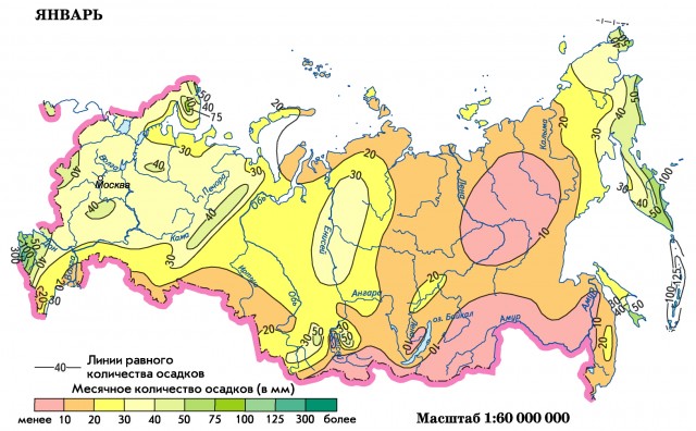
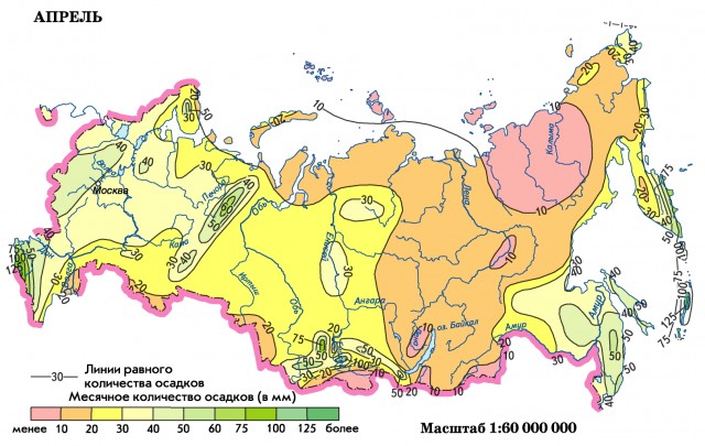
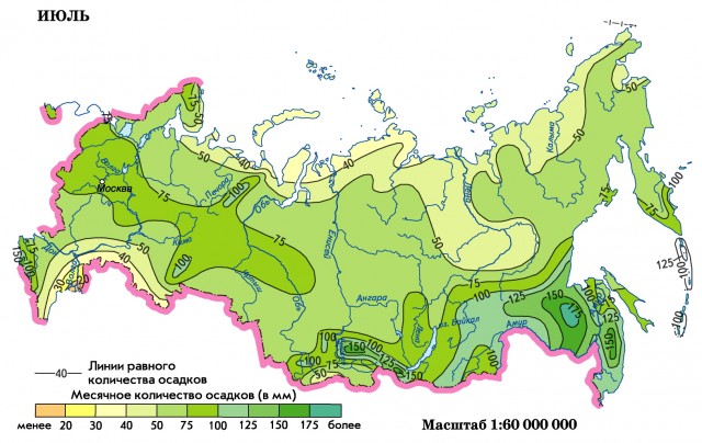
The annual variation of the amount of precipitation is illustrated by maps of the amount of precipitation in the central months of the calendar seasons. In the north of the European part of Russia, the minimum monthly precipitation usually occurs in February – March. Directly on the coast of the Arctic seas, the minimum precipitation occurs more often in March – April. The maximum amount of precipitation in the north of the European part of Russia falls in August on the Arctic coast, and in September - in the foothills of the Urals. In autumn, the amount of precipitation on the coastal strip is greater than at a distance from it. During the rest of the year, precipitation decreases near large bodies of water. A similar annual course of precipitation, but against the background of a greater amount of precipitation, is also observed in the north-west of Russia, however, the summer maximum in August is more pronounced. In the center of the European part of Russia, the minimum precipitation occurs in February – March. The maximum amount of precipitation is more often in July.
In the Volga region, the annual course of precipitation is weak, the amount of precipitation varies little from month to month. A slight increase in precipitation is noticeable only in July. In the lower Volga and North Caucasus, there is a tendency to the appearance of two maximum precipitation during the year: in May – June and in November – December. These maximums are close in magnitude and hardly change from year to year.
On Black sea coast In the Caucasus, the winter maximum precipitation is clearly expressed. It is almost twice the summer one. To the north west coast the maximum amount of precipitation falls in the fall (September – November), the minimum - in the spring and summer period.
In the Urals, the annual course of precipitation changes noticeably, both when moving from north to south, and from west to east. On the western slopes of the Urals, the maximum amount of precipitation falls in July. Moreover, the entire period from June to September is characterized by a significant amount of precipitation (more than 50 mm per month). Beyond the Urals, the maximum is also in July. However, against the background of a general decrease in precipitation in the 'shadow' of the Urals, it is more pronounced. The minimum precipitation throughout this region is observed in February – March, and beyond the Urals, the amount of precipitation in these months is only 10–20% of the summer maximum.
A similar form of the annual course of precipitation (a clearly pronounced maximum in July and a minimum in February – March) persists in the flat part of Western Siberia. On the western slopes of Altai and Kuznetsk Alatau maximum precipitation occurs in autumn (October – November). However, a significant amount of precipitation also falls in summer. Inside mountainous country the maximum amount of precipitation falls in July – August, and the minimum - in January – February. The annual variation of precipitation in these mountain systems characterized by a sharp transition from small winter precipitation to significant summer precipitation, which is generally characteristic of the continental climate.
V Eastern Siberia, on the coasts of the Arctic seas, the maximum amount of precipitation falls in August – September. When moving to the south, the time of the onset of the maximum is gradually shifted to July. On the shores of Lake Baikal, the appearance of a second, smaller maximum in November is noticeable. The minimum amount of precipitation in the entire territory of Eastern Siberia falls on February – March. A similar form of the annual variation in the amount of precipitation with a maximum in July is observed in the interior regions of northeastern Asia. On the coast, maximum precipitation occurs in August.
In areas Of the Far East where monsoon circulation prevails, the annual course of precipitation is also highly irregular. On the mainland, the maximum amount of precipitation falls in August, often exceeding 100 mm per month. The minimum precipitation in this area is most often observed in January – February. Moreover, it does not exceed 8-10 mm per month. On Sakhalin Island, the maximum amount of precipitation falls in September. However, in some cases, there is also a second, winter, maximum precipitation, mainly in December. The minimum precipitation occurs in February.
The forms of the annual course of precipitation in Kamchatka are very diverse. The interior regions of the peninsula have a maximum precipitation in July – August, a minimum in March. The coastal regions are characterized by a two-peaked form of the annual cycle, and the autumn-winter maximum, in November – December, significantly exceeds the spring one, in March – April. The minimum amount of precipitation falls here in February. A similar form of the annual variation in the amount of precipitation is observed on the Kuril Islands.
Thus, greatest amplitude The annual course of precipitation in Russia (30% of the annual precipitation) is observed in Transbaikalia, on the Central Siberian plateau, in Central Yakutia, as well as in the coastal regions of the Far East. The most even annual course of precipitation is observed in the middle zone of the European part of Russia (50-60 ° N), its amplitude does not exceed 5-10%.
I would be grateful if you share this article on social networks:
Site search.
The Moscow region is located in the center of the East European Plain, bordered in the north-west and north with the Tver region, in the northeast with the Yaroslavl region, in the east with the Vladimir region, in the southeast with the Ryazan region, in the south with the Tula region, in the south- west from Kaluga, in the west - from Smolensk region... The city of Moscow is located in the Center of the Moscow Region.
The relief of the Moscow region is predominantly flat, in the west there are hilly heights up to 160 m high, in the east there are vast lowlands.
The climate of the Moscow Region is moderately continental, with snowy, moderately cold winters and humid, moderately warm summers. At the same time, in the eastern and southeastern regions, the continentality of the climate is higher, which is explained by more low temperatures in winter and more high temperatures summer. The coldest month is January (-10 degrees), but with arctic invasions, severe frosts below 25 degrees are possible, lasting up to 30 days throughout the winter. The warmest month is July, with average temperatures of 17-19 degrees. The Moscow region is characterized by frequent, sometimes abrupt changes in weather. In winter the weather - in December and February - thaws are frequent, but they are usually short-lived. In summer, the weather is clear, cloudless, and there is often a strong warming of the surface, which is the cause of drought, forest and peat fires. At the same time, penetration of humid air masses from the south and west is not uncommon, which leads to cooling and rains. Average annual precipitation is 500-700 mm. The maximum precipitation is in July, and the minimum is in March. The snow cover usually appears in November and disappears in mid-April, the height of the snow cover is 25-50 cm.
The climate in the west of the Moscow region in cities such as Mozhaisk, Volokolamsk, Istra, Ruza, Lotoshino, Shakhovskaya is characterized by relatively cold winters and warm summers. The temperature in July is +19 degrees, in February -9 degrees. Southerly and westerly winds prevail, calm is not often observed (frequency of occurrence is no more than 18%). Annual precipitation is 600 mm. Stable snow cover in the west of the Moscow region is observed from December to March, inclusive.
The climate of the northern part of the Moscow region in Dubna, Klin, Dmitrov, Sergiev-Posad, Zelenograd is temperate continental, with temperatures in January -11, in July +18 degrees. In summer, westerly winds prevail, precipitation falls more than at any other time of the year. There are often thunderstorms showers. In winter, arctic anticyclones can cause cold snaps down to -40 degrees and below.
The climate of the southern part of the Moscow region in Kashira, Serpukhov, Chekhov, Podolsk, Kolomna is characterized by warm summers and moderately cold winters. The average temperature in January is 10 degrees, in July +18 degrees. Precipitation falls about 600 mm per year, 2/3 - in the form of rain, 1/3 - in the form of snow. Maximum precipitation occurs in July, minimum - in February. The average height of the snow cover is 30-50 cm.
In the east, in Shatura, Yegoryevsk, Orekhovo-Zuevo, Elektrostal, Zhukovsky, Ramenskoye, the continental climate is more pronounced than in western parts Moscow region. The weather here is colder in winter and more warm in summer... The average temperature in January is -11, July +17 degrees. Frosts are possible in all months except July. Average rainfall is 520 mm. the largest number is in July-August, the smallest in May. The height of the snow cover is 25-35 cm. The prevailing winds throughout the year are southeast and west, and in the winter months - south and southwest.
Weather and climate of Moscow
The climate of Moscow and in the nearby Odintsovo, Krasnogorsk, Khimki, Dolgoprudny, Mytishchi, Lyubertsy, Zheleznodorozhny, Shcherbinka, Reutov is temperate continental with a pronounced seasonality. Winter on average lasts from the second decade of November to the end of March. In winter, there are short periods of severe frosts in Moscow up to -25 .. -30 degrees, but in December and early January there are frequent thaws up to +5 .. + 10 degrees. The coldest month of the year is February, with an average temperature of -7 degrees. Summer in Moscow lasts from mid-May to early September. The daytime temperature in summer often exceeds +30 degrees. The warmest month is July with an average temperature of +19 degrees. During the year, 600-700 mm of precipitation falls in Moscow, most of which falls in the summer. Not rare occurrence for the territory of Moscow there are fogs and thunderstorms. Abnormal weather conditions such as hurricanes, tornadoes and heavy rainfall.
Page 1
Average annual precipitation for 1952 - 1972 is 401 4 mm. Their maximum number (57 6 mm) is observed in June, and the minimum (21 3 mm) - in March. In terms of the ratio of the annual precipitation to the evaporation rate, the territory of the industrial site No. 1 belongs to the regions with insufficient moisture.
Average annual rainfall is 1405 mm; 40% of precipitation falls as snow. The winds here are mountain-valley, especially in summer.
The maximum average annual precipitation, according to our information, falls in India (in Cherrapunji) and reaches 11,500 mm / year.
Thus, the average annual precipitation in different regions of the planet varies over an extremely wide range. In the deserts, the number annual precipitation does not exceed 100 mm (fig. 27) and in areas with damp tropical climate more than 3000 mm of precipitation falls during.
Distributed in areas with an average annual rainfall of 350 - 500 mm. The composition of forbs and legumes in them is close to that of meadow S. On the plain, small fragments of solonetzic S. Lerha, Kermek Gmelin, and pseudo-grass vostrets are found.
At the same time, towards the south, the average annual precipitation increases: from 420 mm in Anapa to 1260 mm in the Tuapse region.
The calculation of treatment facilities is carried out based on the average annual precipitation.
| Recording on the rain gauge. |
The data obtained with these instruments on the average annual precipitation do not give full characteristics rain, as the device does not measure its duration and intensity. Such data are provided by rain gauges-recorders, which automatically record the duration of the rains and the change in their intensity over time.
Average and extreme values of temperature by months and average annual precipitation are given in table. 2 and 3, where, for construction reasons, the route is divided into three sections, which will be described in more detail below.
On average, an amount of water should evaporate per year, equal to the average annual rainfall.
On average, an amount of water should evaporate per year, equal to the average annual rainfall. Of course, the number we received in point (a) exceeds the amount of precipitation, since for the calculations we have chosen such atmospheric conditions when the evaporation process prevails.
The effect of mineral fertilizers sharply decreases with a lack of moisture in areas where the average annual precipitation is 380 - 450 mm. Under these conditions, irrigation increases the efficiency of mineral fertilizers by one and a half to two times.
It is required to calculate the total second water inflow to the workings system if it is known that the average annual precipitation is 455 9 mm, and the runoff coefficient is 0 109; in addition, it was noted that under the influence of drainage, the water level decreased in an area equal to the catchment area F 2 529 km; the operating radius of the drainage unit is 324 m; the perimeter of the drainage area is 2970 m; the duration of the drainage period is taken equal to 12 months.