Our planet is beautiful. And the more a person travels, the more he is convinced of this. But to visit all the beautiful places, cities, lagoons and natural sites, a lifetime is not enough. It is difficult to rank the "Top 10 most beautiful places on the planet." And what can serve as a criterion? The aesthetic sense of people is different. In addition, there are man-made landscapes, the sight of which is breathtaking. These are, for example, tulip fields in Holland, flower plantations in Provence, Hitachi Park near the Japanese city of Hitatinaka, laid out in 1991 on the site of a former military base, or the Rhine Valley with its medieval castles and vineyards. But we still chose a dozen dizzying landscapes that everyone should like. In this article we will list the most beautiful places on the planet with their descriptions and photographs. Do you agree with the rating below?
big blue hole
This unique natural phenomenon is invariably present in all lists of the most beautiful places on our planet. It may not always take the first line. Not far from the Yucatan Peninsula, along the Caribbean coast, the Mesoamerican Barrier Reef stretches for 700 kilometers.
Jacques-Yves Cousteau discovered the Blue Hole at the site of the underwater coral ridge Lighthouse. The phenomenon belongs administratively to Belize and is located one hundred kilometers from the coast of this Latin American country. The hole is a perfectly round hole with a diameter of 305 meters and a depth of 120 m. Among the azure of shallow water, it seems to be a dark blue pupil. Alas, the most beautiful places on the planet are often the most inaccessible. You can also admire the hole from the air. But in order to fully enjoy the beauties of this phenomenon, you need to immerse yourself in it - in the truest sense of the word. If you are a professional diver, you will have an unforgettable sight. The walls are surrounded by stalactites, and this “cave” is inhabited by huge groupers, rays and lemon sharks.
Fly Geyser
The most beautiful places on the planet are not limited to masterpieces created by nature, such as, for example, the Blue Hole. Fly Geyser is a thermal and permanent source on the ranch of the same name in the US state of Nevada.

This beauty arose…by mistake. In 1916, a rancher wanted to cut a well. But in his zeal, he dug into the geothermal pocket. Boiling water began to dissolve mineral rocks and in 1964 came to the surface. Now the geyser throws three jets of water to a height of one and a half meters. Cyanobacteria, algae and calcium carbonate color the liquid in bizarre colors. Unfortunately, few can see this beauty. And not because the ranch is located in impregnable mountains. No, the geyser, which occupies the second position in the "Top of the most beautiful places on the planet" is located 30 km from the town of Gerlach and very close to the R34 road. But the ranchers carefully hide their wealth and let only those they wish look at it. All attempts to buy out the territory in order to make the passage to the geyser available to the public have so far been unsuccessful.
crystal river
The official name of this waterway is Caño Cristales. But the local tribes living in the jungles of Central Colombia call it the "River of Five Colors" or "Escaped from Paradise." Many planets are in the tropics. But Caño Cristales is the most original river.

Its waters are indeed colored red, green, yellow, black and blue. The inhabitants of the river - algae - make them so. A rainbow streams through the foothills of the Amazon rainforest. You can get to this natural phenomenon with an excursion to the Serrania de la Macarena National Park. The tours last four days and run from June to November, during the algal bloom season.
Bend of the Colorado River
Many of the most beautiful places on the planet, photos of which are known to everyone from posters and postcards, are located in the USA. The government of this country reverently protects natural attractions by creating national parks and reserves. The Colorado River itself is very picturesque. But there is such a section in its channel that, bending, forms the shape of an ideal horseshoe. It is best to look at such beauty from a bird's eye view - from the side of a helicopter. The Colorado Bend is located near the city of Page, eight kilometers below Lake Powell and Glen Canyon Dam.

Arizona Wave
To see this phenomenon of nature, you need to be lucky and win the lottery. Why? Because these mountains were formed from ancient sand dunes about two hundred million years ago. Under the influence of winds and rains, the ridge acquired a truly unearthly landscape. However, excessive human exposure can destroy the soft sandstone. Therefore, only twenty people are allowed here per day. Ten tickets are drawn online four months before the tour, and another 10 - the day before, on R89. This highway passes not far from the already mentioned Page. It just so happened that these most beautiful places on the planet - the Colorado bend and the Martian landscape of the Arizona wave - are located nearby.

Cueva de los Cristales Cave
Some of the most beautiful places on the planet, alas, are hidden underground. This natural object was discovered quite recently - in the year 2000. And then the Mexican city of Chihuahua became known not only as the birthplace of the Chihuahua dog breed (Chihuahuan). When they were laying a new mining tunnel, they came across an underground cavity filled with water. Its depth is three hundred meters. But not because of this, the cave got into the Top 10 "The most beautiful places on the planet." The photo shows giant ray-shaped crystals that have grown on the walls of underground halls. Some of them reach the size of fifteen meters. And what is most interesting, these crystals formed in the aquatic environment. For several hundred thousand years, selenite (a kind of gypsum) settled on the walls of the labyrinth. Tourists are not allowed into the cave, because the temperature in it is +60 o C, and the air is hydrogen sulfide.

Salar de Uyuni
The facility is located near the alpine lake Titicaca. It is named after the nearby town of Uyuni (Bolivia). This is the largest dry lake in the world. But not because of the size it got into the rating of "The most beautiful places on the planet." A huge field is covered with small crystals of salt. They shine so brightly in the desert sun that you can't do without goggles. But that's not all. Tourists are taken to look at the salt marsh during the rainy season, which lasts in Bolivia from November to March. Then this natural attraction again turns into a shallow lake. But the high concentration of salt gives the water the properties of a mirror. The reflecting sky merges with the horizon.

Later, the lake is covered with a salt crust. Water breaks out in small cone-shaped volcanoes. The city of Uyuni is also famous for the Fisherman's Island (Isla de Pescadores). In fact, this is an oasis in which eight-meter cacti grow, sometimes up to a thousand years old. And the banks of the salt marsh are surrounded by the Forest of Stones. Fanciful sculptures are created by rain and wind.
Spotted Lake Kliluk
Three seasons a year, this is the most common body of water. And only in the hot summer the surface and the shores of the lake turn into the most beautiful places on the planet. This body of water has the highest concentrations of sodium, calcium, magnesium sulfate, titanium and silver in the world. When the summer heat comes, the top layer of water dries up. Minerals form multi-colored islands - "floes" that float on the surface of the lake, and you can walk on them. Imagine! The color of such icebergs depends on the predominant substance. The facility is located near the town of Osoyoos in Canada, close to the US border.

The Europeans gave the reservoir the name Spotted Lake (Spotted Lake), which is a literal translation of the name given to the object by the Okanagan Indians. For them, Kliluk is still a sacred place. After all, the waters of the lake heal wounds. The indigenous population bought the reservoir and does not allow whites to go to it. You can admire the lake only from a distance - from the highway.
Enchanted Well
If the Canadian lake is included in the Top 10 "Beautiful places on planet Earth" only in summer, then this attraction reveals its magic for only an hour and a half a day. After all, there is an enchanted well at the bottom of an 80-meter cave. The water in it is so clear that you can see the bottom to the smallest detail. But the well is deep - thirty-seven meters! At the bottom rest trees and branches that fell into the cave many years ago. The well reveals its charms from half past eleven to noon. Then the sun's rays penetrate the cave.

As if at the wave of a fairy wand, everything - the reservoir and the walls of the underground cavity - is illuminated with magical sapphire light. This phenomenal natural site is located in the Chapada Diamontina National Park in the northeast of Brazil. Due to the fragility of the eco-system, access to the well is strictly regulated.
marble caves
And closes the list of "The most beautiful places on the planet" lake, lying on the border of Argentina and Chile. It has three names at once. The Argentines call it Buenos Aires, the Chileans - General Carrera, and the local Indian tribes - Chelenko, which means "Storm Lake". The name is very successful, because the climate here is harsh, mountainous. But the lake is teeming with fish, especially trout and salmon. The most beautiful and original corner is on the Chilean side. These are the Marble Caves.

The valuable stone here is apparently invisible. And marble in the caves of different shades - even deep blue. The rays of the sun penetrating under the arches of the caves make the mineral play with hundreds of colors.
We present the most beautiful places of our country, which should be seen not only by every photographer and traveler, but also by every inhabitant of our vast Russia. Read our material and you will see: we all have something to be proud of!
Natural parks, reserves
Lena Pillars, Yakutia
The Lena Pillars is a natural park in Russia, located on the banks of the Lena River in the Khangalassky ulus of Yakutia, 104 km from the city of Pokrovsk. The complex of vertically elongated rocks stretching for many kilometers, bizarrely piled up along the banks of the Lena, a deep valley cutting through the Prilenskoye plateau, never ceases to attract photographers and travelers. The pillars reach the highest density between the villages of Petrovskoye and Tit-Ary.
The height of the rock formations reaches 100 meters. Scientists believe that the formation of rocks began 560-540 million years ago, and the formation of the Lena Pillars as a form of relief - about 400 thousand years ago.
The Lena Pillars Nature Park was organized on the basis of the Decree of the President of the Republic of Sakha (Yakutia) dated August 16, 1994 No. 837 and the government decree dated February 10, 1995 and is subordinate to the regional Ministry of Nature Protection. The area of the park is 485 thousand hectares, the park consists of two branches - "Pillars" and "Sinsky".
Valley of Geysers, Kamchatka

The Valley of Geysers, one of the largest geyser fields in the world and the only one in Eurasia, is located in Kamchatka in the Kronotsky State Biosphere Reserve, which is on the UNESCO World Heritage List as part of the Volcanoes of Kamchatka natural complex.
The valley is a deep canyon of the Geysernaya River, on the sides of which, on an area of about 6 square meters. km there are numerous outlets of geysers, hot springs, mud pots, thermal sites, waterfalls and lakes. On this territory, there is an abnormally high biodiversity and a high contrast of natural conditions and microclimate. The ecosystem of the Valley of Geysers is unique for the whole country. The reserve regime operates on the territory of the valley.
Since 1992, helicopter excursions have been organized here, under an agreement with the reserve, there is a strict system of rules for organizing excursions in order to maintain the balance of the ecosystem. In 2008, according to the voting results, the Valley of Geysers was included in the list of seven wonders of Russia.
Weathering pillars, Komi Republic

Pillars of weathering (Mansi blockheads) is a geological monument located in the Troitsko-Pechora region of the Komi Republic on the territory of the Pechoro-Ilychsky reserve on Mount Man-Pupu-ner (“Small mountain of idols” translated from the Mansi language), in the interfluve of the Ichotlyaga and Pechora rivers . There are many legends associated with this extraordinary place. Pillars are considered one of the seven wonders of Russia.
Weathering Pillars are located quite far from inhabited places. Getting to them is already a feat in a sense. For this, by the way, you need to get a pass from the administration of the reserve. From the side of the Sverdlovsk region and the Perm Territory there is a walking route, from the side of the Komi Republic - automobile, water and foot routes.
About 200 million years ago, there were high mountains in the place of stone pillars. Rain, snow, wind, frost and heat gradually destroyed the mountains, and first of all the weak rocks. Hard sericite-quartzite schists were less destroyed and survived to this day, while soft rocks were destroyed by weathering and carried by water and wind into relief depressions.
One pillar, 34 m high, stands somewhat apart from the others. Six others lined up at the edge of the cliff. The pillars have bizarre outlines and, depending on the place of inspection, either resemble the figure of a huge man, or the head of a horse or a ram. Indeed, this place is ideal for a photographer's fantasy! In the past, the Mansi deified the grandiose stone sculptures, worshiped them, but climbing the Manpupuner was considered the greatest sin.
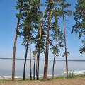
Curonian Spit, Kaliningrad Region

The Curonian Spit is a sandy spit located on the coast of the Baltic Sea and the Curonian Lagoon. It is a narrow and long strip of saber-shaped land separating the Curonian Lagoon from the Baltic Sea and stretching from the city of Zelenogradsk in the Kaliningrad region to the city of Klaipeda (Smiltyne) (Lithuania). The name of the spit comes from the name of the ancient tribes of the Curonians, who lived here before the colonization of Prussia by the Germans.
Length - 98 kilometers, width ranges from 400 meters (near the village of Lesnoy) to 3.8 kilometers (near Cape Bulviko, just north of Nida).
The Curonian Spit is a unique natural and anthropogenic landscape and a territory of exceptional aesthetic significance: the Curonian Spit is the largest sand body, which, along with the Hel and Vistula, is part of the Baltic sand spits complex, which has no analogues in the world. The high level of biological diversity due to the combination of different landscapes - from desert (dunes) to tundra (raised swamp) - gives an idea of important and long-term ecological and biological processes in evolution.
The most significant element of the relief of the spit is a continuous strip of white sand dunes 0.3 - 1 km wide, partly approaching the highest in the world (up to 68 m). Due to its geographic location and northeast-southwest orientation, it serves as a corridor for migratory birds of many species flying from the northwestern regions of Russia, Finland and the Baltic countries to the countries of Central and Southern Europe. Every year, in spring and autumn, 10 to 20 million birds fly over the spit, most of which stop here for rest and feeding.
Favorable climatic conditions allow you to relax on the Curonian Spit from May to November. In 2000, the Curonian Spit was included in the UNESCO World Heritage List.
Nature reserve "Stolby". Krasnoyarsk region

The reserve is located on the northwestern spurs of the Eastern Sayan, bordering on the Central Siberian Plateau. The natural boundaries of the protected area are the right tributaries of the river. Yenisei: in the northeast - the Bazaikha river, in the south and southwest - the Mana and Bolshaya Slizneva rivers. From the northeast, the territory borders on the city of Krasnoyarsk, the border of the reserve can be reached by bus. The reserve was founded in 1925 on the initiative of the city residents to preserve natural complexes around the picturesque syenite remnants - "pillars". At present, its area is 47,219 hectares. Submitted to the UNESCO World Heritage List.
lakes
Lake Baikal, Eastern Siberia

It is unlikely that Baikal needs any descriptions, but still ... Baikal is the deepest lake on the planet, the largest natural reservoir of fresh water. The lake and coastal areas are distinguished by a unique diversity of flora and fauna. Locals and many in Russia traditionally call Baikal the sea.
The value of the maximum depth of the lake - 1642 m - was established in 1983 by L. G. Kolotilo and A. I. Sulimov during hydrographic work. The average depth of the lake is also very high - 744.4 m. In addition to Baikal, only two lakes on Earth have a depth of more than 1000 meters: Tanganyika (1470 m) and the Caspian Sea (1025 m). One of the visiting cards of Russia, a place that you need to see with your own eyes at least once in your life!
Lake Seliger, Tver and Novgorod regions

Another place that needs no introduction. By the way, Seliger has another name - Ostashkovskoye Lake, after the name of the city of Ostashkov standing on the lake shore. The area of the lake is 260 sq. km, including about 38 sq. km. km falls on the islands (there are more than 160 of them on Seliger). The largest among them is the island of Khachin. The area of the entire pool is 2275 sq. km.
Seliger receives 110 tributaries. The largest are the rivers Krapivenka, Soroga and Seremukha. Only one river Selizharovka flows from it. The lake lies at an altitude of 205 meters above sea level and is of glacial origin. This explains its peculiar shape - it is not a lake in the usual sense, but rather a chain of lakes stretching from north to south for 100 km and interconnected by short narrow channels. The coastline with a length of more than 500 km is notable for its indentation - capes overgrown with forests, deep picturesque bays protruding into the land, diverse in shape of the island.
The water in Seliger is clear, transparency reaches 5 meters. On the shores of the southern part of Lake Seliger are the city of Ostashkov and the estate "New Yeltsy".
Lake Kezenoy-am, Chechen Republic

Kezenoy-am is a lake on the border of the Vedeno region of the Chechen Republic and the Botlikh region of Dagestan. This is the largest and deepest lake in the North Caucasus, located at an altitude of more than 1800 meters above sea level. The surface of the lake is 2.4 sq. km.
The depth of the lake reaches 74 m. The length of the lake from north to south is 2 kilometers, and from west to east - 2.7 kilometers. The maximum width is 735 meters. The length of the coastline is 10 kilometers.
Lake Baskunchak
Akhtubinsky district, Astrakhan region

Baskunchak is a salt lake with an area of about 115 sq. km in the Akhtubinsky district of the Astrakhan region, about 270 km north of the Caspian Sea, and 53 km east of the Volga. Lake Baskunchak is part of a unique natural complex, which includes Mount Bolshoye Bogdo. In 1997, the Bogdinsko-Baskunchaksky natural complex was declared a reserve (Bogdinsko-Baskunchaksky reserve), where a special environmental regime was established on an area of 53.7 thousand hectares.
On the coast of the lake there are deposits of medicinal clays. In June-August, tourists come to the lake to swim in brine and take mud baths. There is no need to talk about the beauty of these places. There are no less photographers than those wishing to improve their health.
Jack London Lake, Magadan Region

Located in the upper reaches of the Kolyma River in the Yagodninsky district of the Magadan region, lies among the mountains, at an altitude of 803 meters, the length of the lake in the northwest direction is 10 kilometers, the depth is 50 meters.
There are many small lakes around Jack London Lake. The most prominent in size are the lakes Mechta, Anemone, Gray Gull, Invisible, Neighboring, Kudinovskie lakes. One of the most beautiful and exotic lakes in the Far East. Old-timers say that the lake got its name thanks to an unusual find made by the “discoverers”. When the lake was discovered, on the shore, the researchers found Jack London's book "Martin Eden".
Lake Elton, Volgograd region

Elton is a salty drainless self-sustaining lake in the Pallasovsky district of the Volgograd region, located near the border with Kazakhstan. It is considered the largest mineral lake in Europe and one of the most mineralized in the world. They say that the name of the lake comes from the Mongolian word "Altyn-Nor" - "gold mine".
The area of the lake is 152 sq. km. Until 1882, salt was mined on the Elton, in 1910 the medical sanatorium "Elton" was founded on its shore (moved to a new location in 1945). In 2001, the lake and the surrounding areas of virgin steppes (106 thousand hectares) became part of the State Institution "Natural Park" Elton "".
Blue Lakes. Cherek-Balkar Gorge, Kabardino-Balkaria

A group of five karst lakes in the Cherek region of Kabardino-Balkaria is located at the foot of a rocky ridge, from where the Cherek-Balkar gorge begins. Located at the entrance to the gorge, Blue Lake is a unique natural phenomenon, interesting not only for Kabardino-Balkaria, but also on a national scale. Lower Blue Lake has several names: Chirik-kel (balk.) - rotten (stinking) lake; Sherej-ana (kab.) - mother of Cherek; Psykhurei (kab.) - round water (lake), natural artesian well.
The uniqueness of the Lower Blue Lake lies in the fact that with a relatively small surface (only 235 × 130 m), its depth reaches 258 meters. The water temperature on the surface in winter and summer is about +9 degrees. Not a single stream or river flows into the lake, but about 70 million liters flow out daily. At the same time, the level of the lake is unchanged, which is explained by powerful underwater sources. The blue color of the water is due to the presence of hydrogen sulfide and the refraction of light rays in a deep pool.
The nature here is quite picturesque: green hills, dense beech forests on steep slopes, and in the distance, in a blue haze, peaks sparkling in the sun. Closer to Babugent, the greenery becomes brighter, juicier. Near the village of Babugent there is a fork in the road. At the beginning of the road to the lake, there is a cave in the rock, in which traces of an ancient site of the 5th-10th centuries AD were found. Now many bats settle there, and sometimes, in bad weather, shepherds with flocks of sheep hide.
Seydozero, Kola Peninsula, Murmansk region

Lake in the Lovozero tundra on the Kola Peninsula. "Seid" in translation from the Sami language means "sacred". The lake is located at an altitude of 189 m above sea level. The length of Seydozero is 8 km, the width is from 1.5 to 2.5 km.
According to a number of science fiction writers and ufologists, one of the alleged places of existence of the Hyperborean civilization. Seekers of the unknown have been exploring these places since 1922.
Lake (reservoir) Zyuratkul. Chelyabinsk region

Zyuratkul is located in the Satkinsky district of the Chelyabinsk region on the territory of the national park of the same name. One of the highest (724 m above sea level) reservoirs of the Southern Urals. The reservoir is surrounded by mountain ranges covered with dark coniferous forests. To the southwest is the Nurgush ridge - the highest ridge in the Chelyabinsk region. The main river that feeds the reservoir is the Bolshoi Kyl. Near the source of the Satka River and the dam is the small village of Zyuratkul, connected by bus with the city of Satka.
Previously, Zyuratkul was a natural lake. Now - a reservoir formed by a dam built on the Big Satka. A giant geoglyph was found near the lake. About forty stone tools made of quartzite were also found. The stone chipping technique makes it possible to date the tools to the Neolithic and Eneolithic (VI-III millennium BC). Researchers are still inclined towards the Copper-Stone Age (IV-III millennium BC). It is noted that at that time there were practically no forests in the Southern Urals (they appeared only 2,500 years ago), so the figure was easy to build and then view from a neighboring ridge until it was covered with a layer of soil.
Until the winter of 2012, another popular attraction was located on the shores of Lake Zyuratkul - Kitova Pier, which was also called the "Ural Disneyland". But in the fall of 2012, by a court decision, it was demolished.
Mountains and volcanoes
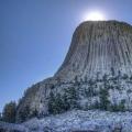
Elbrus, Kabardino-Balkaria

Elbrus is a stratovolcano located on the border of the republics of Kabardino-Balkaria and Karachay-Cherkessia. Elbrus is located north of the Greater Caucasus Range and is the highest peak in Russia. Considering that the border between Europe and Asia is ambiguous, often Elbrus is also called the highest European mountain peak, thereby referring it to the list of "Seven Peaks".
The height of the western peak is 5642 m, the eastern one is 5621 m. The gorges of Adylsu, Shkheldy, Adyrsu, Donguz-Orun and Ushba massifs are very popular among climbers and mountain tourists. Elbrus is the most popular ski resort in Russia. The total area of Elbrus glaciers is 134.5 sq. km. The most famous of them are: Big and Small Azau, Terskol.
Altai mountains

The Altai Mountains represent a complex system of the highest ranges in Siberia, separated by deep river valleys and vast intramountain and intermountain basins. The mountain system at the junction of the borders of Russia, Mongolia, China and Kazakhstan. It is divided into Southern Altai (Southwestern), Southeastern Altai and Eastern Altai, Central Altai, Northern and Northeastern Altai, Northwestern Altai.
The Altai, Katunsky nature reserves and the Ukok plateau together form the UNESCO World Heritage Site "Altai - Golden Mountains". Thousands of tourists come to Altai. This is a favorite place for photo tours and independent trips.
Plateau "Divnogorie", Liskinsky district, Voronezh region

"Divnogorye" - a hill and a museum-reserve in the Liskinsky district of the Voronezh region of Russia. It is located 10 km west of the district center on the right bank of the Don River and 80 km south of Voronezh. The museum was founded here in 1988, and in 1991 it received the status of a museum-reserve. Currently, the museum-reserve is one of the most popular and most recognizable sights of the Voronezh region. Every season, from May to October, it is visited by more than 60 thousand tourists.
The area of the museum-reserve is more than 11 sq. km. The maximum height of the plateau above sea level reaches 181 meters, relative - 103 meters (the mouth of the Quiet Pine River at the confluence with the Don, which flows at the foot of the plateau, is located at an altitude of 78 m above sea level).
Dombay-Ulgen, Karachay-Cherkess Republic

Dombay-Ulgen is the peak of the western part of the Dividing Range of the Greater Caucasus (on the border of Abkhazia and the Karachay-Cherkess Republic). Dombay-Ulgen is the highest peak of Abkhazia, located east of the village of Dombay, has three peaks: western (4036 m), main (4046 m) and eastern (3950 m).
A steep ridge extends from the main peak to the north, ending in a lowering - the "Dombay saddle". From the Dombai saddle, there is a classic route (category 3B) going up, accessible for climbing in one day with a descent to the camp.
Putorana Plateau, Krasnoyarsk Territory

The Putorana Plateau is a mountain range located in the northwest of the Central Siberian Plateau. In the north and west, the plateau breaks off with a steep ledge (800 m or more), while the southern and eastern parts are characterized by gentle slopes. The maximum height of the plateau is 1701 m, among the highest peaks are the Kamen (1701 m), Holokit (1542 m), Kotuyskaya (1510 m) mountains. In the north, the Putorana Plateau borders on the Taimyr Peninsula. The name Putorana, translated from Evenki, means "lakes with steep banks."
The area of the plateau is 250 thousand square kilometers, which is comparable to the territory of Great Britain. On the territory of the plateau is the Putoransky State Natural Reserve, recognized by UNESCO as a World Heritage Site.
Marble canyon Ruskeala, Republic of Karelia, Ruskeala village

Mountain Park "Ruskeala" is a tourist complex located in the Sortavalsky district of the Republic of Karelia, near the village of Ruskeala. The main object of the complex is a former marble quarry filled with groundwater.
The quarries, discovered by pastor Alopeus, began to be developed at the beginning of the reign of Catherine II. The first developments were led by Captain Kozhin, who was advised by Italian experts. Today, the length of the quarry from north to south is 460 meters, the width is up to 100 meters. The distance from the highest point of the quarry wall to its bottom is over 50 meters. The transparency of water reaches 15-18 meters.
Ruskeala marble was used in the construction of the most beautiful and significant buildings in St. Petersburg and its palace suburbs. St. Isaac's Cathedral was lined with it, the floors of the Kazan Cathedral were laid out, the window sills of the Hermitage were made, the windows of the Marble Palace and the facade of the Mikhailovsky Castle were framed, as well as the underground halls of the Primorskaya and Ladozhskaya stations of the St. Petersburg metro. In 2010, a significant part of the filming of the film "The Dark World" took place in Ruskeala.
Eastern and Western Sayans. Eastern Siberia

Eastern and Western Sayans - a common name for two mountain systems in southern Siberia. They distinguish the Western Sayan (length 650 km, height up to 3971 m - Mount Mongun-Taiga, which is the top of the ridge of the same name - the highest peak in Eastern Siberia, however, more often this ridge is not classified as the Sayan, but is distinguished into a separate mountain system - the mountains of Tuva), consisting from leveled and peaked ridges, on which there is no glaciation, separated by intermountain basins, and the Eastern Sayan (length about 1000 km, height up to 3491 m - Mount Munku-Sardyk) with typical mid-mountain ridges bearing glaciers. The rivers belong to the Yenisei basin. Mountain taiga prevails on the slopes, turning into mountain tundra.
The Western Sayan in the southwestern part borders on Altai. Its main ridge is the Dividing Sayan Range with the highest point - Mount Kyzyl-Taiga (3121 m). The ridges of the Western Sayan are characterized by steep slopes, indented relief, and vast areas of stone placers. The height of the ridges in the west does not exceed 2500-3000 m, in the east it decreases to 2000 m.
The Eastern Sayan stretches almost at right angles to the Western. Its ridges form a system of "white mountains" (Manskoye, Kanskoye) and "squirrels", which got their name because of the snow on the peaks that does not melt all year round. In the central part, in the upper reaches of the Kazyr and Kizir rivers, several ridges form a "knot" with the highest point - Grandiose Peak (2982 m). In the south-east there are the highest and hard-to-reach ridges - Big Sayan, Tunkinsky Goltsy, Kitoy Goltsy, Kropotkin. The highest point of the Eastern Sayan - Munku-Sardyk (3491 m) is located in the ridge of the same name. Between the Sayan ridges there are more than a dozen basins of various sizes and depths, the most famous of which is the Abakan-Minusinsk basin, famous for its archaeological sites. It is worth noting a large number of waterfalls.
Almost everywhere in the Sayans, dark coniferous taiga spruce-cedar-fir forests prevail, rising in the western and central parts to altitudes of 1500–1800 m and more; light deciduous-cedar forests form the upper boundary of the forest at altitudes of 2000–2500 m. The fauna is as rich as the flora. The largest city located in the Sayans is Krasnoyarsk.
Mountains of Shikhany. Republic of Bashkortostan

Shikhany - isolated hills in the Bashkir Cis-Urals, consisting of four single mountains: Tratau, Shakhtau, Yuraktau and Kushtau, which form a narrow chain stretched along the Belaya River for 20 km. Shikhany are located near the cities of Sterlitamak and Ishimbay. They are unique monuments of nature - the remains of a barrier reef formed in the warm sea of the early Permian period. The imprints of ancient plants and animals have been preserved in the stones of which these shikhans are made.
The highest shihan is Tratau (or Toratau). Its height is 402 meters above sea level, and its relative height is 280 meters. At its foot, the ruins of a women's prison, one of the islands of the Gulag archipelago, have been preserved. Shikhan Tratau flaunts on the coat of arms of the city of Ishimbay, is a symbol of the Ishimbay region of Bashkiria. In the past, this mountain was considered sacred.
Volcano Krenitsyn. Sakhalin Region, Onekotan Island

An active volcano on the Onekotan Island of the Great Kuril Ridge. The largest two-tiered "volcano within a volcano" in the world is located in the southern part of Onekotan Island. The height of the volcano is 1324 m.
The volcanic cone rises in the form of an island inside Lake Koltsevoe lying at an altitude of 400 m (diameter about 7 km). The lake is surrounded by somma - the walls of the more ancient Tao-Rusyr caldera (heights 540–920 m with a base diameter of 16–17 km).
Only one historical eruption is known, which happened in 1952.
Volcano Tyatya, Kuril Islands

An active volcano on the Kunashir Island of the Great Kuril Ridge, on the territory of the Kuril Reserve. In geographical terms, Tyatya is a stratovolcano of the somma-vesuvius type ("volcano in a volcano"). The height reaches 1819 m (the highest point of Kunashir; in 1977 and subsequent years, the southeastern part of the edge of the summit crater collapsed and most of the material collapsed inside the northeastern crater. As a result, the total height of the volcano decreased by about 30-50 meters and is currently probably less than 1800 meters above sea level).
The height of the somma is 1485 m, it has a regular truncated cone with a diameter of 15–18 km at the base and up to 2.5 km at the annular ridge. The foot slopes of the volcano are decorated with coniferous-broad-leaved forests with bamboo and thickets of stone birch and elfin cedar. In the forests at the foot you can often meet a bear. The path to the volcano is difficult, but most tourists get to the volcano from Yuzhno-Kurilsk.
caves
Orda cave, Perm region

Orda Cave is located on the southwestern outskirts of the village of Orda in the Perm Territory, on the left bank of the Kungur River. Consists of "dry" and underwater parts. The length of the dry part is 300 meters, underwater - 4600 meters. To date, the Ordinskaya cave is the longest flooded cave in Russia. In addition, part of the cave is the longest siphon in the CIS - 935 meters.
The cave is ranked 21st among the longest gypsum caves in the world. Famous photographer Viktor Lyagushkin dedicated a whole photo project to Orda Cave.
Kungur cave, Perm region

This is one of the most popular attractions in Siberia and the Urals, a natural monument of all-Russian significance. The cave is located in the Perm Territory, on the right bank of the Sylva River on the outskirts of the city of Kungur in the village of Filippovka, 100 km from Perm.
A unique geological monument - one of the largest karst caves in the European part of Russia, the seventh longest gypsum cave in the world. The length of the cave is about 5700 m, of which 1.5 km is equipped for tourists. The average air temperature in the center of the cave is +5 °C, the relative humidity in the center of the cave is 100%. The Kungur cave contains 58 grottoes, 70 lakes, 146 t. "organ pipes" (the highest - in the Etheric grotto, 22 m) - high shafts, reaching almost to the surface.
Architecture
Leaning tower of Nevyansk. Sverdlovsk region, city of Nevyansk

Not everyone knows that in Russia we have our own kind of Leaning Tower of Pisa - an inclined tower in the center of Nevyansk, built in the first half of the 18th century by order of Akinfiy Demidov.
The height of the tower is 57.5 meters, the base is a square with a side of 9.5 m. The deviation of the tower from the vertical is about 1.85 m, and the greatest slope is observed at the lower tier (3 ° 16 "). The exact date of construction of the tower is unknown, different sources give dates ranging from 1721 to 1745.
The tower is a massive quadrangle with 3 octagonal tiers built on top. Inside the tower is divided into several levels - floors.
The purpose of the first floor is not exactly established. Demidov's office was located on the second floor, and during the Soviet era there was a prison in it. On the third floor there was a laboratory: traces of silver and gold were found in the soot taken from the chimneys of furnaces. According to one version, Demidov minted counterfeit money here. According to another, here Demidov, secretly from the state treasury, smelted silver and gold, which was mined in his mines in Altai.
Even higher is the so-called "auditory room". Its peculiarity is that standing in one corner of the room, you can clearly hear what they say in the opposite corner. The effect observed in the room is associated with the special shape of the ceiling - it is vaulted and at the same time slightly flattened.
On the seventh and eighth floors there are chiming chimes created by the English watchmaker Richard Phelps in 1730. The tower is completed by a roof and a metal spire with a weather vane hoisted on it, made of perforated iron, in which the noble coat of arms of the Demidovs is engraved.
There is a legend saying that the tower tilted due to the flooding of the cellars with all the workers who minted counterfeit money. By Decree of the Council of Ministers of the RSFSR No. 1327 of August 30, 1960, the tower was included in the list of historical monuments to be protected as monuments of national importance.
Ivolginsky datsan. Republic of Buryatia, the village of Verkhnyaya Ivolga

Ivolginsky datsan is a large Buddhist monastic complex, the center of the Buddhist traditional Sangha of Russia, which is the largest Buddhist community in Buryatia. One of the brightest monuments of Russian history and architecture. Located in the village of Verkhnyaya Ivolga, 36 km from the center of Ulan-Ude.
Swallow's Nest. Republic of Crimea

Among all the sights of Crimea, it is not easy to choose one thing. But we decided to stop at one of the most inspiring places. The Swallow's Nest is a monument of architecture and history, located on a sheer 40-meter Aurora cliff of Cape Ai-Todor in the village of Gaspra (Yalta City Council).
The structure resembles a medieval knight's castle like the Belem tower or the Miramare villa near Trieste. The first wooden building on this site was erected for a retired Russian general after the Russian-Turkish war of 1877–1878; it can be seen on the canvases of famous marine painters: I. K. Aivazovsky, L. F. Lagorio, A. P. Bogolyubov, and also in photographs of the time.
The second owner of this amazing dacha was the court physician A. K. Tobin. There is also very little information about him. After his death, the house was owned by a widow for some time, who sold the plot to the Moscow merchant Rakhmanina. She demolished the old building, and soon a wooden castle appeared, which she called "Swallow's Nest".
The Swallow's Nest got its present form thanks to the oil industrialist Baron Steingel, who liked to relax in the Crimea. Steingel bought a summer cottage on the Aurora Rock and decided to build a romantic castle there, which resembles medieval buildings on the banks of the Rhine. The project for the new house was commissioned from engineer and sculptor Leonid Sherwood, son of architect Vladimir Sherwood, author of the Historical Museum on Red Square in Moscow.
At the beginning of World War I, the estate was bought by the Moscow merchant P. Shelaputin, who opened a restaurant in the castle. In the 1930s, there was a reading room of the local Rest House, but the premises were recognized as emergency and closed.
In 1927, the Swallow's Nest was damaged during a strong earthquake. It was not until 1967–1968 that repairs were made. In addition to the monolithic slab, the entire structure was surrounded by anti-seismic belts. The tower, increased in height, acquired more decorative effect thanks to four spiers. In 2013, cracks were found in the foundation slab, and in the autumn the visit was suspended for design work on the reconstruction - strengthening the rock.
And 6 more amazing places:
Chara Sands, Trans-Baikal Territory

Chara Sands is a tract in the Kalarsky district of the Trans-Baikal Territory, which is a sandy massif about 10 km by 5 km in size. The Chara sands are located in the hollow of the same name, in the foothills of the Kodar ridge, 9 kilometers from the village of Chara, between the valleys of the Chara, Middle Sakukan and Upper Sakukan rivers. The massif is a geological monument of nature of the geomorphological type of federal rank.
BAM station Novaya Chara is 10 kilometers away. The massif is elongated from the southwest to the northeast and occupies an area of about 50 sq. km. There are no such large massifs of free-flowing moving sands in any basin of Transbaikalia. The Chara sands are outwardly similar to the deserts of Central Asia. The vegetation is slightly different from the taiga: there are areas with larch, dwarf birch and moisture-loving dwarf pine. In the northeastern part of the tract there are two small lakes - Alyonushka and Tayozhnoye.
Avacha Bay, Kamchatka Territory

Avacha Bay is a large non-freezing bay of the Pacific Ocean near the south-east coast of the Kamchatka Peninsula, it is the main transport "gateway" of the Kamchatka Territory. The main advantage of the bay is that it is one of the largest bays in the world: it can accommodate any ship in the world!
The length of the bay is 24 kilometers, the width at the entrance is 3 kilometers, the total area of the water surface is 215 sq. km. Depth up to 26 meters. The Avacha and Paratunka rivers flow into the bay. The cities of Petropavlovsk-Kamchatsky and Vilyuchinsk are located along the shores of the bay. The bay is the main base of the Russian Pacific Fleet in Kamchatka.
A kind of symbol of the bay and its attraction are the Three Brothers rocks, located at the exit to the open Avacha Bay.
Commander Islands. Aleutsky District, Kamchatka Territory

Commander Islands - an archipelago of four islands in the southwestern part of the Bering Sea of the Pacific Ocean, administratively part of the Aleutsky District of the Kamchatka Territory of Russia. The islands are named after the navigator Commander Vitus Bering, who discovered them in 1741. On the largest of them - Bering Island - there is a grave of a navigator. Commander Islands - a place of mixing of Russian and Aleutian cultures. They have great potential for the development of northern tourism.
Patomsky crater. Irkutsk region

Patomsky crater - a cone of crushed limestone blocks on the slope of a mountain in the Patomsky Highlands in the Irkutsk region. Discovered in 1949 by geologist Vadim Viktorovich Kolpakov. Among the local population it is called the "Nest of the Fiery Eagle", also known as the "Kolpakov's Cone", "Dzhebulda Crater", "Yavaldinsky Crater".
This is a geological object unique in its characteristics, which is a ring structure of the central type with a bulk cone composed of limestone and other rocks. The Patom crater was formed over a long period of time about 500 years ago.
The diameter of the crater along the ridge is 76 m. The cone is crowned with a flat top, which is an annular shaft. In the center of the funnel there is a hill up to 12 m high. The total volume of the cone is estimated at 230-250 thousand cubic meters, the mass is about a million tons.
Agura waterfalls. City of Sochi, Krasnodar Territory

Cascade of waterfalls located on the Agura River in the Khostinsky district of Sochi. The distance from the Black Sea coast is 4 km. Further up the river - the Middle waterfall, then the Upper.
The Lower Agur waterfall is the first and most interesting of the three large waterfalls on the Agura River. It consists of two cascades: the lower one is 18 m high and the upper one is 12 m high. Under it is a wide and deep pool of blue water. From the Devil's hole canyon to the Lower waterfall is approximately 1.5 km. Behind the first waterfall, a series of stairs and rises lead up through 500 m to the Middle Agur waterfall - 23 meters, and then to the Upper - 21 meters waterfall. Near the Upper waterfall, to the left of the path, there are rocks called Eagles.
Vasyugan swamps. Tomsk, Novosibirsk and Omsk regions

Some of the largest swamps in the world are located in Western Siberia, between the Ob and Irtysh rivers, on the territory of the Vasyugan plain, which is mostly within the Tomsk region, and in small parts - the Novosibirsk and Omsk regions and the Khanty-Mansi Autonomous Okrug.
The swamp area is 53 thousand square meters. km (for comparison: the area of Switzerland is 41 thousand sq. km), the length from west to east is 573 km, from north to south - 320 km.
Vasyugan swamps arose about 10 thousand years ago and have been constantly increasing since then - 75% of their modern area was swamped less than 500 years ago. Marshes are the main source of fresh water in the region (water reserves - 400 cubic km), there are about 800 thousand small lakes, many rivers originate from swamps, in particular: Ava, Bakchar, Big Yugan, Vasyugan, Demyanka, etc. d.
Vasyugan swamps are home to numerous local fauna, including rare ones. Of the rare species of animals in the swamps, in particular, reindeer, golden eagle, white-tailed eagle, osprey, gray shrike, peregrine falcon live. Squirrels, elks, sables, wood grouses, white partridges, hazel grouses, black grouses are present in significant quantities, mink, otter, wolverine are in smaller quantities. The flora also includes rare and endangered plant species and plant communities. Cranberries, blueberries, and cloudberries are widely distributed among wild plants.
Now the fauna and flora of the swamps is under threat due to the development of the territory during the exploration and exploitation of oil and gas fields.
In preparing the article, materials from Wikipedia were used.
Happy travels!

Earth is the most beautiful planet in the solar system, and perhaps the entire universe. The nature of our planet surprises with its beauty, brightness of colors, unique views and diverse landscape.
Beautiful caves and golden beaches, beautiful forests and majestic mountains make up the beauty of the Earth. Some of the corners of our planet do not leave the pages of fashion guides. But, there are places that are rarely found in such literature.
We open our review from the symbol of the mysterious Myanmar - the ancient city of Bagan. It is called the city of a thousand pagodas. This place was the capital of the Bagan kingdom. His greatness was so strong that the best minds and masters of antiquity aspired to Bagan. Thanks to them, Buddhist temples and other beautiful structures were built.
 Only a few of them survived to our time. The most significant of them is the Shwezigon Golden Pagoda. It was built in 1057 on the site indicated by the white elephant carrying the bandage, tooth and rib of the Buddha. These relics are kept in the temple until now.
 The photo of the most beautiful and amazing places in the world should definitely include other attractions of Bagan: Ananda temples, Htilo-Minlo, Shveleykto and Bu-paya pagoda.
Colored rocks of Zhangye Danxia (China)
 The most amazing places on the planet can be built by human hands or nature. Colored rocks, which are located in the Chinese province of Gansu, are natural formations made of multi-colored sandstones. Recent studies show that more than 100 million years ago there was an ocean here. The silt colored the sandstone and made the rock formations so original.
 Today, the mountain peaks of Danxia near the town of Zhangye are included in the UNESCO World Heritage List. So that tourists can enjoy the views of these mountains, the locals have built many boardwalks and paths with which you can walk between these amazing mountain peaks.
Yusupov Palace (Russia)
 But, back to man-made miracles. In any almanac of the most beautiful places in the world, you will find such an architectural monument as the Yusupov Palace. It is located in the heart of St. Petersburg on the Moika River. Built in the 18th century for the niece of Peter the Great, Princess Praskovya, it only passed into the possession of the Yusupovs in 1830. But, since then, he is associated only with this legendary surname. This palace is the site of the assassination of Grigory Rasputin.
Li River (China)
 Another beautiful place in China is the Li River. This is one of the most picturesque water bodies on our planet. Starting as a small stream in the Mao'er Mountains, it runs like a "silk ribbon" through the Guangxi Zhuang Autonomous Region of China. The locals call this Lijiang River. It is recognized as the cleanest river in the Middle Kingdom. Its main attribute is the majestic karst giants. They were formed with the help of water and wind over many centuries. These mountain formations have poetic names and attract tourists from many countries of the world with their beauty.
 You can enjoy the beauty of the Lijiang River with the help of a cruise ship or using the service of local "gondoliers".
Meteora monastery complex (Greece)
 There are many amazing places in our world. If we talk about architectural monuments, then most of them are in Greece. This country, which became the ancestor of modern Europe, is proud of its legendary "ruins". But the monasteries of Meteora are no less popular. Their main feature is their amazing location: they crown the high peaks of the mountains of Thessaly.
 Christian hermits hid in the mountains from Albanians, Turks and ordinary robbers. Over time, students gathered around them, who built monasteries of amazing beauty and resembling the nests of huge birds for themselves and their teachers. The word "Meteora" is translated as "soaring in the air."
Mount Erebus (Antarctica)
 Erebus volcano is one of the most interesting places in the world. It is famous for the fact that on its territory you can observe a lake of real lava. This natural phenomenon is unique. The volcano was named after the ship of the expedition, James Clark Ross, who discovered this natural phenomenon. The glow of this volcano attracts everyone who travels on Lake Ross. It is a kind of visiting card of Antarctica.
Rice Terraces (Philippines)
 The list of the most interesting places in the world must be continued with the rice terraces of the Philippines. They are even called the eighth miracle of counting. And this is not surprising. These man-made gardens were built by the ancestors of today's locals over 2,000 years ago. Plowed, multi-level fields not only fed the Ifuago people, but were also an excellent defensive structure.
Union of Fire and Ice (Kamchatka - Russia)
 Talking about interesting places on Earth, one cannot ignore Kamchatka. On the territory of this peninsula, you can find 28 active and 160 extinct volcanoes. If you want to climb fire-breathing mountains, watch the spawning of salmon and see the largest bears in the world, then be sure to go and temper your spirit with the help of Kamchatka. The amazing places of nature of this place are conducive to hiking, extreme and sea tourism.
Death Valley (USA)
 Another natural monument is the Death Valley. It must be included in all lists of interesting places in the world. We will not bypass this unique place either. Formed many thousands of years ago at the bottom of the sea, this valley is striking in its natural phenomena. Here, literally, stones walk. Leaving bizarre footprints on the petrified mud. But, if you decide to get here, then you need to prepare for the intense heat. During the day, the temperature here rarely falls below 50 degrees.
Guam Gorge (Russia)
 The gorge is located in the upper reaches of the Kurdzhips River in the Krasnodar Territory. The natural beauty of this gorge attracts tourists all year round. But, here you can do not only the contemplation of the magnificent flora and fauna, but also extreme tourism. Rock climbing is especially highly developed in the Gum Gorge.
Beach with caves near the Algarve (Portugal)
 One of the most amazing places in the world, no doubt, are the Portuguese caves, which are located in the southernmost province of the country of port wine and the birthplace of Cristiano Ronaldo. The most famous of them is the Algarve de Benagil cave. It is called the most beautiful cave in the world. Wind and sea water - these two creators have created a magnificent example of one of the best travel destinations in the world.
Sagano Bamboo Grove (Japan)
 For many of us, the beauty of the Land of the Rising Sun is associated with cherry blossoms. In this country, even special tours are being created, with the help of which you can observe the alternate flowering of this plant in all provinces of Japan. But, another equally popular symbol of Japan is the Sagano Bamboo Forest. Looking through the photos of the most beautiful and amazing places in the world, you will definitely find several images of a picturesque grove of evergreen bamboos there.
 These majestic plants, when blown by the wind, make sounds reminiscent of the popular wind chimes. This beautiful park was created in the 14th century by the monk Muso Soseki.
 The nature of Sokotora seems like a setting for science fiction films. Charming vegetation, many of which are unique to this island, divine beaches and silence. This is just what you need for happiness and a serene paradise vacation.
Lake Baskunchak (Russia)
 It is called the most salty lake in the world. In terms of salinity, Baskunchak exceeds the famous Dead Sea. This reservoir is located in the Akhtubinsky district of the Astrakhan region. Not far from this lake is the Baskunchakskaya cave. Its one and a half kilometer length attracts speleologists.
In today's selection, we will talk about the most unusual corners of our planet. They are unusual for their landscapes, when you see these photographs, you might think that these places are on some other planets, in other galaxies, but not on Earth. The most amazing thing is that the initial impression is wrong - our planet is able to surprise us, constantly presenting new surprises and mysteries.
So, let's move on to the story of the most unusual corners of our planet. We have already told you about places surrounded by many mysteries (The most mysterious places on the planet). In the same selection, we will focus on unusual landscapes that arouse admiration for their appearance alone - these are real wonders of nature. We always try to provide you with maximum information about the topic of interest, so in the rating we will refer to articles already written earlier - there you can learn more about all the places on our list. 
Let's start with the most unearthly part of our planet - the Dry Valleys in Antarctica. This desert is unique in that it is the driest place on earth. There has been no precipitation here for several million years. This place, in terms of its climate, is closest to Mars, therefore it is of particular interest to NASA. Mars rovers are being tested here, large-scale research is being conducted in all directions. It is the only part of Antarctica not covered in ice. In the valleys there is a frozen lake with extremely salty water, mysterious bacteria and organisms were discovered under the ice - this discovery served as confirmation of the theory that life exists on Mars. Read more about the Dry Valleys in the article 
In second place is the island of Socotra - the landscapes of this island are unique, and look more like alien ones. The island is geographically isolated from Africa for 6 million years, replete with many extremely rare species of flora and fauna - a third of them are endemic and are found only here. Despite the hot and dry climate, many amazing and beautiful plants grow here, many of which are about 20 million years old. More detailed information about this place in the article - 
Next on the list of “Most Unusual Places on Earth” is the Rio Tinto Quarry in Andalusia, Spain. The huge careers of Rio Tinto create a surreal, moon-like landscape. The quarries are named after the river of the same name that flows here and leaches minerals from huge craters. Mining here has been carried out for many centuries, so the river turned bright red-orange, its acidity and saturation with metals just rolls over. At the moment, mining in this region has been stopped, and attracts crowds of tourists and photographers to Andalusia. 
Let's move on, we still have something to surprise you with :) I bet you have never heard of Spotted Lake, let alone seen such stunning landscapes. The lake is located in British Columbia, Canada. Depending on weather conditions and the season, the lake crystallizes and turns into a certain color. A lot of “spots” are formed on the lake - circles of minerals. This is the world's largest concentration of magnesium sulfate (Epsom salt), calcium and sodium, as well as silver and titanium. This place is sacred to the native Indians of Canada, and is famous for its healing properties - for this he was given the name Kliluk. More in the topic "" 
Another unusual landscape is the world's largest salt lake, Uyuni Salt Flats. This is a beautiful area with a huge salty desert, active volcanoes, large islands of cacti and geysers. On the surface of the lake you can ride a jeep - admire the unusual, sometimes unearthly beauty of this place. well viewed from space, and is one of the points for calibrating satellites 
In Brazil, there is another unusual place - Vale da Lua, which means Valley of the Moon. It is a water-washed rock formation with natural swimming pools. Vale da Lua is located in the Brazilian forest Chapada and is one of the oldest rock formations on the planet, consisting of quartz and crystals. 
There are also unusual places in Japan. This is Bloody Pond, one of the famous ones. There are nine unusual geyser springs in this city, but the most famous among them is the Blood Pool with bright red hot water. This color is due to the high content of iron in the water. This pond is also the most photogenic of all the springs. 
At number eight on our list, the Shilin Stone Forest in China is a stunning example of karst topography. The rocks are made of limestone and shaped by water that has destroyed everything but these tree-like pillars. Known as the "First Wonder of the World" since the Ming Dynasty
Another miracle of nature is the Richat Structure in Mauritania. It is also called the Eye of the Sahara. Richat is about 30 miles in diameter and is visible from space. The formation was originally thought to be the result of a meteorite impact, but modern geologists believe it is the result of erosion. The reason for its round shape is still a mystery that scientists around the world are struggling with. 
The famous gates to Hell - Darvaz in Turkmenistan, also made it to our list. This place frightens with its power, thousands of tons of lava and heat emanating from the bowels of the Earth. There is a burning crater in the middle of the Karakum desert, its diameter is 60 meters and the depth is 20 meters. At its core, Darvaz is a gas well, and the history of its discovery is quite interesting. Researchers drilled a well here to extract gas, but as a result, this huge abyss opened up, the gas had to be set on fire so that no one was poisoned. Read more about the interesting history of this unusual place in the article “Darvaz, the gates to Hell” 
The Eisreisenwelt ice caves close the list of the most unusual places on earth. These caves differ from any other caves in their icy unusualness. When you get here, you feel like you are in some other fairy-tale world. There are many ice caves in the world, but the Eisreisenwelt caves are the largest among them. Their total length is 40 kilometers, and only a small part is open to the public. But even this is enough for thousands of tourists every day to admire the grandeur and unusualness of this place.

Beauty is considered a purely subjective concept, however, contemplating the most beautiful places in the world that nature has worked on, we can come to the realization of the fact that the real natural beauty that surrounds us should not go unnoticed. Traditional tourist routes usually do not cover even a small part of the world that is created thanks to the most talented "architects", which are nature and time. A detailed overview of the most amazing in terms of aesthetics and unique features of the landscape of places on the planet will provide an opportunity to understand what the true beauty of the universe is.
First place - Bolivia. The beauty of Lake Uyuni
Perhaps it is worth starting our top with this unique salt lake, which occupies the largest  area in the world. Many call this Uyuni a place where time slows down. Surprising is the fact that the surface of the lake can be overcome on foot. During the rainy season, Uyuni undergoes some changes, eventually becoming a large-scale mirror square with a very beautiful view. At a distance of three kilometers from the city, which bears the same name, there is a cemetery, which was the last stop for a large number of steam locomotives, which in the old days served as vehicles designed to transport various minerals (they were mined on the territory of local mines).
The saline surface is a completely optimal alternative to the expanses of the ocean in terms of such important aspects as checking and adjusting the operation of tools designed to carry out the sounding process using satellites that are in earth orbit. The territory of the lake is occupied by entire islands, the main flora of which are cacti. This spectacle is incredibly controversial, but at the same time so amazing that it will definitely need to be captured with a camera.

Second place - Cinque Terre
A place called the Cinque Terre is considered the most beautiful national park in Italy, which  located in the eastern part of the Riviera. Such a picturesque place as the Cinque Terre is fanned by the spirit of the Middle Ages in Italy. The territory is occupied by about five small villages, the architectural features of which are presented in the form of defensive structures erected back in the days when pirate raids were often made in this area. A reliable level of land protection was provided thanks to the rocky coastline, which combines unforgettable beauty and serious danger at the same time.

Such a beautiful corner filled with romance. Many stone beaches and narrow paths appear before the attention of tourists. One such path is called the "path of love", and a lot of legends are associated with it, in which the most noble and temperamental representatives of Europe are represented.
Third place - Pamukkale
Now, perhaps, it is worth turning to the southwestern part of Turkey, which is characterized by a unique and  a magnificent geological phenomenon - calcareous tuff, or rather a rocky area created on the basis of this natural material. This place is the main source of streams that fall down massive stone steps. Many waterfalls and unique pools are formed here, characterized by an unusual origin. Cotton Castle - this is the poetic name given to the amazing landscape by the inhabitants themselves. Thanks to the thermal springs and natural terraces of Pamukkale, located at the foot of the mountains, an excellent view is created, which attracts many tourists to this area every year. This picture appears to be a well of water saturated with a large amount of calcium, against the general background of an excellent landscape, which is represented by white tones.


Fourth place - Yunnan Rice Terraces
Another simply stunningly beautiful place on the planet is the territory of rice fields,  which is located in China. This area is located in the mountainous regions of the province called Yunnan. At the terraces, the degree of extension is characterized by several tens of kilometers, exactly repeating the bend of the general relief. The general uniqueness of this area lies in the basic nature of the ecological type system, which was formed in an independent way. Rice is planted when February comes, because during this period the soil is renewed thanks to the mountain mines. The beginning of the autumn period is considered the time when the inhabitants begin to harvest. The tourism season begins by the end of autumn, continuing until spring. It is during this time period that natural terraces become the main object of attention of tourists, striking, first of all, with a mirror type of surface that reflects the rays of the sun, while creating a beautiful color spectrum.


Fifth place - the beauty of the blue hole in Belize
The central part of the atoll (one of the many objects related to the coral barrier  reef near the coast of Belize) is represented by the most beautiful landscape - a blue hole, which appears as a cave, disappearing somewhere in the depths. A natural phenomenon of a natural nature is very common, but it is this abyss that has especially incredible dimensions (the depth level is about one hundred and twenty meters, and the cave is about three hundred meters in diameter). Extreme divers are especially attracted to this place. A deep-sea cave can become a real paradise for people who have turned diving into a real meaning of life. Jacques Yves Cousteau conducted extensive research here, which brought great popularity to this area in the future.


Sixth place - beautiful views of the Arizona wave
In the border area separating the states of Arizona and Utah, there is a plateau on which there are  sand rocks of incredibly beautiful shape, which are called waves, because of the funny uneven shapes and colors with a high degree of saturation. In order to make the way to this amazing place, professional photographers have to go through a difficult path: a flat road in such an area is not expected. The creation of a peculiar structure of a magnificent landscape took place over a long period of time through the transformation of dunes from sand into rocks of a solid type.


Seventh place - features of Jiuzhaigou National Park
In the southeast of China, there is the territory of Sichuan province, which attracts a huge number of  tourists. And all thanks to the beautiful Jiuzhaigou Nature Reserve, which occupies the server of the region. It is a unique natural object under the strictest protection. Waterfalls and lakes in large numbers are hidden from curious tourists by the mountain ranges of Tibet. These waters are called colored because they carry a special composition.
Not every person is able to get to this reserve, however, not so long ago, the mountainous region acquired an airport that provides an opportunity to get to this area straight from the territory of Shanghai. In order for tourists to feel maximum comfort in this area, the paths in the mountains were ennobled by local workers.
In the old days, the territory was occupied by nine separate settlements.


Eighth place - Features of Plitvice Lakes
The territory of Croatia, which is considered very mysterious and  colorful edge. First of all, I would like to turn specifically to the Plitvice Lakes, which are located in a large-scale national state park. The nature of the surrounding nature sets a mystical atmosphere. The territory of the park is surrounded by very dense impenetrable forests, which the locals call the "Devil's Forest".
Almost each of the sixteen lakes is located within the mountain valley. There is a connection between them, which is why, thanks to the purest mountain streams, grandiose noisy fountains are formed. From year to year there are more and more waterfalls, because the water causes the effect of destruction to limestone rocks. The total area of water areas is about two square kilometers. The location of the waterfalls themselves is observed at various levels. Thanks to the reservoirs, the formation of two picturesque complexes is carried out - the Upper Lakes and the Lower Lakes.


Ninth place - Features of the valley of 10 Peaks. Canada
Canada is considered a harsh land, but incredibly attractive due to the beauty of the "cold"  nature. There is one beautiful place here, which stands out for its incredible natural beauty, which is called the “10 peaks” valley, which is located right at the very foot of 10 mountains, bearing the single name Vekchkemna. This area is located not so far from the famous Moraine Lake, which has a glacial origin. In this area, the workers have laid a very large number of hiking trails, which provide an opportunity to give a real assessment of the local attractions. There is one mountain that has a very bizarre name - "twenty dollars", because for some time an image of an identical character was imprinted on the surface of a bill that has the same denomination.


Tenth place - impressive views of Mount Roraima
The beautiful view of the mountain is a kind of symbol that characterizes the neighborhood of states  South America - Venezuela and Brazil. Roraima represents mountain ranges, located in a very long chain, which rise directly above the wilds of the great Amazon. This area gained loud popularity at the time when Conan Doyle's novel appeared, which told about the time period when our planet was inhabited by dinosaurs who chose mountain ranges as a safe haven. Due to the unusual landscape and the unique atmosphere in this area, a character of complete detachment from the real surrounding world is created, representing an inexhaustible source of inspiration for many literary figures.


Eleventh place - the territory of the Maldives
A huge archipelago containing many (more than 1000) small islands, considered  Separately, a real tourist paradise, located in the Indian Ocean. Turquoise-colored water, an area of white sandy beaches, fruits of an exotic nature - all this great variety encompasses the Maldives. This area is considered ideal and simply heavenly excellent to spend winter or summer holidays here, actively entertain or spend a honeymoon.
Here, anyone can go diving and bring this type of leisure to perfection, because the level of visibility under the water surface is almost perfect. You can also visit individual uninhabited islands, which can be perfect for solitude and romantic dates.