ANTARCTICA.
Lesson topic:
Antarctica. Geographical position... Discovery and exploration. The nature of the mainland.
Goals and objectives of the lesson:
1. Consider the features of the geographic location of the mainland.
2. To acquaint students with the names of travelers and scientists who contributed to the discovery and study of Antarctica.
3. To give an idea of the peculiarities of the nature of Antarctica. 4. To acquaint students with modern research in Antarctica. Help students understand the practical value of studying the nature of Antarctica.
5. To develop in students the ability to name and show the features of the components of the nature of Antarctica, to establish causal relationships, to determine climatic indicators on a map and climatograms, to predict trends in changes in the nature of the earth under the condition of melting of the ice sheet, to work with various sources geographic information.
Knowledge, abilities, skills:
1. Be able to independently determine the geographical position of the mainland, describe the coastline.
2. Students should know the names of the travelers.
3. Continue work on the formation of the ability to work with an atlas and a contour map ( interactive maps).
Equipment: maps of Antarctica (physical, climatic), illustrations of natural objects of Antarctica.
DURING THE CLASSES
The question is often asked: why is it necessary to study Antarctica? We still know very little about this huge icy continent: what is hidden under its icy armor, what riches it conceals, how it flows in this area the globe various geophysical processes associated in one way or another with the processes developing all over the planet? - A. Gusev.
I. Organizational moment
II. Learning new material
Dress warmly, as you have to make a journey across the coldest continent of the Earth, cross icy deserts, visit six - yes, six! - its poles. You will once again visit the scientific stations of this continent, swim and sunbathe in the polar summer in its oases, admire the icebergs off its shores and be surprised at the unusual credulity of its indigenous inhabitants towards the people.
"Fight and seek, find and not give up",
words that became a monument to Robert Scott
| date | Researcher | Event |
| J. Cook (England) | First crossing of the Antarctic Circle. Didn't find "South Land". |
|
| 1819–1821 | F. Bellingshausen and M. Lazarev (Russia) Antarctica was discovered on January 16, 1820. | Discovery of the Russian mainland round the world expedition |
| C. Wilkes (USA) | Discovery of Wilkes Land |
|
| J. Dumont - Durville (France) | Discovery of Adelie Land |
|
| D. Ross (England) | Discovery of the sea and ice barrier of Ross, Victoria Land |
|
| K. Borchgrevink and L. Christensen (Norway) | First landing on the coast of Antarctica |
|
| K. Borchgrevink (Norway) | First wintering on the mainland |
|
| R. Scott (England) | Discovery of the Ross Ice Shelf |
|
| E. Shackleton (England) | First attempt to cross Antarctica |
|
| 14.12.1911 | R. Amundsen (Norway) | First reaching the South Pole. Studied the nature of the islands. |
| R. Scott (England) | Second reaching the South Pole |
|
| D. Mawson (Austria) | Proof of solid land between 45 and 150 V. D. |
|
| R. Bird (USA) | First airplane flight over the South Pole |
|
| M. Somov (USSR) | The first Soviet Antarctic expedition |
|
| A. Treshnikov (USSR) | Creation of the Vostok station, registration of the minimum temperature (-89 о С) |
|
| E. Tolstikov (USSR) | Reaching the pole of inaccessibility |
|
| V. Boyarsky (Russia - USSR) | Research in East Antarctica |
Ice sheet
What do you know about the nature of Antarctica? (Student responses). Put on your sunglasses, we set off to explore the ice sheet.
How much ice is in Antarctica? What is under the thick ice sheet? Even 35-40 years ago, these questions could not be answered with confidence.
Questions for self-searching for answers have been written:
What is the average elevation of the mainland? ( 2040 meters away)
What lithospheric plate lies at the base of Antarctica? ( Antarctic lithospheric plate)
What ancient platform underlies most of the mainland? ( Antarctic platform)
What forms of relief are associated with ancient platforms? ( Plains and lowlands)
Which part of the mainland has a more indented coastline? ( Western part Antarctica)
Whoever is the first to cope with the questions raises his hand to the assessment.
Quite right, about 1/3 of the continent's surface lies below ocean level. However, Antarctica also has mountain ranges, and mountain ranges.
It is in the western part of the Antarctic Peninsula that mountains stretch, which tectonically are a continuation of the Andes. South America... The highest mountain range of Antarctica is located here - 5140 m.
The Transantarctic Mountains stretch across almost the entire continent. Find them on the map on page 18. Also in the western part of Antarctica lies the Byrd Plain.
The Vernadsky Mountains stretch in the east of Antarctica, and the Schmidt Plain is also located here.
In the eastern part of the continent, under continuous ice cover, flat areas alternate with mountain ranges.
There are also active volcanoes in Antarctica.
Find the Ross Sea on the map in the atlas on page 18. On one of the islands in this sea there is active volcano Erebus is a witness of active mountain building processes in the area.
As you can see, many landforms are named after the great scientists and explorers of Antarctica, perpetuating their names on the map.
Millions of years ago, the territory of modern Antarctica was part of the southern supercontinent - Gondwana.
And the composition of the rocks that make up the relief of Antarctica is similar to those on other continents, which once again proves the kinship of the southern continents.
Now scientists have established that at the heart of most of the continent - in its eastern half- the Antarctic platform lies.
Almost the entire continent is covered with an ice sheet, the average thickness of which is about 2000 m, and in the eastern part the maximum thickness reaches 4500 m.
The average height of the continent, taking into account the ice sheet, is 2040 m. This is almost three times higher than the average height of other continents.
The ice cover of Antarctica contains about 80% of all fresh water on the Earth and 90% of the volume of all natural ice on the planet.
What happens if there is a complete melting of Antarctica's glaciers (students' answers).
Scientists estimate that the complete melting of the Antarctic ice sheet would lead to a rise in ocean levels by 60-65 meters!
Under the influence of its gravity, Antarctic ice spreads from several centers to the periphery of the cover. In different parts, this movement goes at different speeds. In the center of Antarctica, as in Greenland, ice moves slowly, at the glacial edge its speed increases to many tens and hundreds of meters per year. And here the ice streams move fastest, discharging into open ocean... Their speeds often reach a kilometer a year, and the Pine Island Glacier “makes” several kilometers a year. Such ice streams reaching the ocean form icebergs.
(Student message about icebergs)
Of course, the entire glacial shell of the planet is now not the same as it was 20 thousand years ago, but it did not disappear, but only shrank. It has been reduced more than once in the past, after which it has been restored again and again. Large fluctuations glaciations are a characteristic feature of the ice age, which is still ongoing.
Ice relief
Antarctica, like other southern continents, was part of Gondwana. Modern research methods have made it possible to obtain a clear understanding of the subglacial topography of the continent.
About 1 / W of its surface lies below ocean level. At the same time, mountain ranges and massifs were discovered under the glacial shell.
In the western hemisphere, in the Pacific sector of the mainland, during the period of alpine folding, mountain systems- continuation of the Andes of South America - Antarctic Andes.
The highest point is located here - the Vinson Massif (5140 m). The deepest depression is 2555 m.
On the islands in the Ross Sea there is an active volcano - Erebus - witness to active mountain-building processes in the area.
In East Antarctica, under a continuous ice cover, flat areas of the surface alternate with mountain ranges 3000-4000 m high. They are composed of ancient sediments, similar to the rocks of other continents that were part of the ancient continent of Gondwana.
Climate
How do you feel, frozen? Why is it so cold? Let's figure it out!
The formation of the climate of any territory is influenced by the so-called climate-forming factors. Let us recall what climate-forming factors affect the climate of the continent? ( geographic location, underlying surface and air currents)
A student is called to the blackboard, who fills in a previously prepared diagram, and explains the influence of these factors, in general.
Draw this reference diagram in your notebooks. Open the map of the Climatic zones of the world in the atlas and say in which climatic zones x is Antarctica? ( temperate, subantarctic, antarctic)
Within what climatic zone does most of Antarctica lie? ( within the Antarctic climate zone)
Quite right. Guys, the climate of Antarctica
very harsh. There are several reasons for this.
Note the map of Antarctica on the board. The mainland, as we have said more than once, occupies a near-polar position. We know that the further from the equator to the poles, the smaller the angle of incidence of the sun's rays and the less solar heat enters the territory. Consequently, this geographical position determines the least amount of solar heat that Antarctica receives in comparison with other continents.
So, the first reason is the circumpolar position of Antarctica.
Pay attention to the board for the air movement in the troposphere.
What air currents circulate over the mainland - ascending or descending? ( downdrafts)
If these are downdrafts, tell me which pressure area is located over Antarctica - high or low? ( high pressure area)
Right. Downdrafts do not form clouds and are dry air. So, dry, cold and very transparent air circulates over the mainland.
Such air does not trap the heat coming from the ground, which further contributes to the cooling of the mainland surface.
So, the second reason is the lack of cloud cover.
Consider the following factor. Antarctica has a unique underlying surface - an ice sheet, which cannot be found on any other continent.
Thus, the icy, mirror-like surface of Antarctica reflects up to 90% of the sun's rays entering the mainland in summer time.
Thus, these three factors determine the harsh climate of Antarctica.
Average daily temperatures in the interior regions of the mainland, even in summer, do not rise above -30 ºС, and in winter they are below -70 ºС
It is in Antarctica that the so-called cold pole of the earth- at the Vostok station, the lowest temperature on the planet was noted - -89.3 ºС.
In addition to extremely low temperatures, strong winds are observed in Antarctica. This is due to the difference in atmospheric pressure over the mainland and the ocean.
In which direction does the wind blow - from high pressure to low pressure or vice versa? ( from high pressure to low)
Thus, strong constant winds blow towards the sea, blowing off huge masses of snow from the mainland. Therefore, special residential buildings are required here - attached to the ground with metal cables, on high piles.
In what climatic zones is Antarctica located? (students' answers)
Using the climatic diagrams (Figure 80), determine the climatic zones and their main properties in Antarctica, draw a conclusion about the type of climate. (Student responses)
Almost all of Antarctica is located in the Antarctic climate zone. The climate is especially harsh in the interior regions of the continent. The average daily temperature there, even in summer, does not rise above -30 ° C, and in winter it is below -70 ° C. Polar explorers at Vostok station recorded the lowest temperature on Earth (-89.3 ° C). That is why the Vostok station is called the cold pole of the Earth. Special clothing is used to work in such conditions.
But Antarctica has not one, but 6 poles.
1. South Pole of the Earth - geographical, 90 ° S .;
2. South magnetic pole of the Earth - 72 ° 25'S. sh., 155 ° 16'E (plateau of Adélie Land in the eastern part of Antarctica, on January 16, 1909), 70 ° S. NS. and 150 ° east. d. in 1950, in the area of the Victoria Land mountain plateau, and by 1977 it had shifted from land to water, not far from the coast, near the French station Dumont d'Urville;
3. South geomagnetic pole - 78 ° Z6'S. latitude, 109 ° 54 'east d. (in the middle of the twentieth century), the area of the Vostok scientific station;
4. Pole of relative inaccessibility 82 ° S, 60 ° E, in the summer of 1958. there was a scientific station - the Pole of Inaccessibility;
5. Pole of cold - Vostok station - 89.2 ° С in 1984;
6. Pole of winds - Cape Denison on Adelie Land (wind speed here can reach 70-80 m / s, and in 1912-1913 235 days were noted in 12 months with a wind speed of 18 m / s and more).
Antarctica is called the "refrigerator" of the Earth.
Where do you think it is colder in the northern hemisphere or in the southern? Prove your answer. (Student responses).
The southern hemisphere is much colder than the northern one. What explains such a harsh climatic conditions of the continent, except for its geographical position? To do this, consider the manifestation of climate-forming factors (see Fig. 21) in Antarctica. Trace air movement in Antarctica using Figures 17 and 18.
The area of what pressure is over Antarctica? (Student responses)
As can be seen from the analysis of the circuits, there is an area of high atmospheric pressure with descending currents of air that do not form clouds. Air masses flow from the center of the mainland to the coastal zone. The Antarctic air formed here is distinguished not only by low temperatures, but also by amazing transparency and dryness. It transmits well the heat coming from the surface of the Earth.
What is the reason for the severity of the climate? (Student responses)
The underlying surface in Antarctica is very different from the underlying surface of all other continents of the Earth. In the summer, Antarctica receives a lot of solar heat. But about 90% of this heat is reflected by snow and ice and goes into space. Thus, the severity of the climate is due to three factors. First, the geographic location. Secondly, by the presence of a powerful ice cover. Thirdly, the absence of cloud cover, which contributes to the further cooling of the territory. 10% of the heat that is absorbed by the surface of Antarctica, as well as 90% of the reflected heat from the ice surface of the sun, go into space.
In Antarctica, geographic zoning is well expressed in the distribution of temperatures and precipitation in the solid state. Due to the large difference in temperature and atmospheric pressure over the interior regions of Antarctica and over the washing oceans, constant winds blow from the mainland in the coastal strip. Towards the shore, they intensify and sometimes reach hurricane force. These winds blow huge amounts of snow from the mainland into the ocean. Therefore, special residential buildings are required here: on high piles and attached to the ground with metal cables.
In winter, the seas are covered with solid ice.
Taking advantage of climate map Antarctica, confirm that the law of latitudinal zoning is in effect in Antarctica. To do this, trace the change in temperatures and precipitation by 70 0 v. etc.
Open the atlas on page 9 for a map of Natural Areas of the World.
Within what natural areas is Antarctica located? ( antarctic desert)
Quite right, most of Antarctica lies within the Antarctic Desert. This is for the most part a lifeless territory, devoid of flora and fauna.
Modern organisms of Antarctica are represented by mosses, lichens, microscopic fungi and algae. Life is almost everywhere. Even in the area of the cold pole, bacteria were found in the snow.
Penguins are typical inhabitants of Antarctica. The most common species is the small Adélie penguin. Emperor penguins are especially beautiful. Penguins cannot fly, but they swim well, feed on fish, molluscs and crustaceans.
In summer, about a dozen species of birds nest on the coast - skuas, albatrosses, cormorants.
V ocean waters ah, rich in plankton, there are seals, blue whales, sperm whales, killer whales, sea lion, elephant seal.
Most of Antarctica is devoid of flora and fauna. Here is the Antarctic Desert. (State the reasons for its formation.)
Modern organisms of Antarctica are represented by mosses, lichens, microscopic fungi and algae, etc. Life is present almost everywhere. even in the area of the cold pole, bacteria were found in the snow.
What is it that can be seen in the distance?
Near the coast of the mainland, we found unusual areas with lakes, completely free from ice, and in the summer and from snow, surrounded by a glacier. Such areas are called Antarctic oases. The area of oases is from several tens to several hundred square kilometers. In summer, the rocks, free from snow and ice, absorb up to 85% of the solar heat, heat themselves up to + 20-30 ° C, and heat the surrounding air. Here the air temperature is 3-4 ° C higher than above the surrounding glaciers. In the shallow lakes of some oases, the water temperature reaches + 10-15 ° C. The oases of Antarctica can be seen as hotbeds of warmth and life in icy desert... The lakes of the oases are rich in a variety of algae. Antarctic oases are a unique phenomenon. There are no such natural conditions anywhere on Earth. They are of great interest to researchers. In addition, in oases devoid of ice cover, it is possible to directly study the upper layers of the lithosphere, to identify minerals, various kinds of ancient remains.
What animals live in Antarctica? (Student responses)
Animal world connected with the oceans washing the mainland. Antarctic waters are rich in plankton, which is a food source for whales, seals, fish and birds. Several species of cetaceans are found here, among them the largest animals on our planet are blue whales.
So, attention, we are sinking into the sea off the coast of Antarctica to hear with the help of a hydrophone - a device that picks up noise in the depths of the ocean. Do you hear loud sounds that resemble the rhythmic beat of some kind of motor? The source of its origin moves at a speed of 12 km / h and from time to time stops working, as if someone turned it off. What is it? (Student responses). Submarine? No! The owner of the "motor" is a mustachioed whale fin whale. What do you know about him? (Student responses)... There are 8 tons of blood in the body of this sea giant, it is pumped by the heart, which weighs 200-250 kg. But since the sounds of the heartbeat are absorbed by his multi-ton body, which has a thick (10 cm) layer of subcutaneous fat, the pulse is heard only through his opening mouth when the fin whale eats. Pinnipeds are widespread, as well as sperm whales and killer whales.
In summer, about a dozen bird species nest on the coast. Penguins are typical inhabitants of Antarctica. They do not fly, but they swim well, feed on fish, molluscs and crustaceans. There are about 17 species of penguins. The most common is the small Adélie penguin. Especially beautiful are the emperor penguins, weighing up to 50 kg and more than a meter high. They breed their offspring in a harsh winter. Nests are not made, but eggs are kept on their paws, pressing a warm belly to the fluff. Antarctic and snow petrels nest high in the mountains. On the coast in summer you can see cormorants and skuas.
Meaning modern research Antarctica.
Would you like to be polar explorers, explorers of Antarctica? Why? (Student responses)
Research in Antarctica is taking place under extremely difficult conditions. What explains the huge interest in the study of the icy continent? The interest is explained by the desire of people for knowledge. The earth is our home, and it is important for people to know what is going on in it. In the bowels of Antarctica, a variety of minerals have been discovered: coal, iron ore, non-ferrous metals. Found traces of oil, natural gas. Scientists suggest that there is gold, diamonds, uranium. The oceanic waters of Antarctica are especially rich in large marine animals and fish. Antarctica has huge reserves of fresh water. The processes taking place in Antarctica inevitably affect the nature of the surface of the entire Earth. For example, changes in the level of the World Ocean largely depend on the behavior of ice (accumulation of ice, change in speed, melting). The atmosphere over Antarctica affects the movement of the air masses of the entire planet. The ice sheet, which appeared 20 million years ago, contains a wealth of information about the history of development. natural complexes Earth, about the influence of the Cosmos on our planet. At a depth of 2 km, it is already 180 thousand years old. Studying it, you can not only compile a chronicle climate change on the planet, but also to predict the climate of the future.
III. Lesson summary - We have completed an amusing trip into amazing lost World Antarctica, where, following the discoverers and famous travelers, they set foot on its icy expanses, visited the Antarctic Desert and were surprised by its oases, visited six poles and an active volcano. We sailed along the entire coast and sank into the depths of the sea. Admired the icebergs and the inhabitants of the mainland. You can rightfully be considered polar explorers and connoisseurs of Antarctica. Please answer briefly and show on the map:
III. Homework -§ 48-49;
| Card number 1. What is Antarctica? Are the shores ghosts in Antarctica? | Card number 10. Name the area of the mainland Antarctica. |
| Card number 6. What are the winds in Antarctica? How does ice move in Antarctica? | Card number 2. What is the main feature of the geographic location of the continent? On the back of the questionnaire, sketch out the outline of Antarctica. Note the only major peninsula in Antarctica and the mountains located on it. |
| Card number 4. Who and when was Antarctica discovered? What is an oasis in Antarctica? | Card number 3. Where is the lowest temperature recorded on Earth? What is the absolute minimum temperature .. How thick is ice in Antarctica? |
| Card number 8. Name the most on the mainland. How much fresh water is stored in the world in Antarctica? | Card number 7. Why the nature of Antarctica is so dramatically different from the nature of other continents southern hemisphere? Which constellation "hangs" over the North Pole, and which over the South Pole? |
| Card number 24. Prove that Antarctica is a continent of science and peace. How much precipitation does Antarctica have? | Card number 9. Name a flightless bird that thrives in Antarctic waters. On land, she is very clumsy. Several species of this bird are found in Antarctica. What is the relationship between internal structure and the relief of Antarctica? |
| Card number 23. What is the largest penguin in Antarctica and the smallest? Who discovered the South Pole and when? | Card number 12. Which continent is separated by the world's widest strait from Antarctica? On the back of the questionnaire, sketch out the outline of Antarctica and mark this strait. Why is Antarctica called a continent - a nature reserve? |
| Card number 16. Which continent was Antarctica once a part of? What does the last relief of Antarctica look like? | Card number 13. Name the volcano located off the coast of Antarctica, on one of the coastal islands of the Ross Sea, and its height. What plants are found in Antarctica? |
| Card number 5. Why is sailing around Antarctica so difficult? What is the current washing over Antarctica? | Card number 15. What place is Antarctica in terms of area among other continents? How is such a harsh climate of Antarctica formed? |
| Card number 21. In what climatic zones is Antarctica located? What is at the base of most of Antarctica? | Card number 17. Who was the first to set himself the task: "Open Antarctica"? In what century did this happen? Sketch out the outlines of Antarctica. Mark (write) the seas surrounding Antarctica. |
| Card number 22. How many landforms does Antarctica have? Name the extreme point of the mainland and its coordinates. | Card number 18. What is the average height of Antarctica and the maximum. Is there a permanent population in Antarctica? |
| Card number 25. What is the area of ice in Antarctica? What mineral deposits have been found in Antarctica? | Card number 20. What is the largest animal in the waters of Antarctica? On the back of the questionnaire, sketch out the outline of Antarctica and mark the mountains that are in Antarctica. |
| Card number 11. What oceans is Antarctica washed by? What is at the base of the Antarctic Peninsula? | Card number 14. Describe the geographical position of Antarctica in relation to the equator, the prime meridian. In which hemisphere is the mainland? When did the scientific research relay start in Antarctica? |
| Card number 19. What are the remains of trees found in Antarctica talking about? What areas of Antarctica are favorable for animals? | Card number 26. What is the main reason for the low rainfall in Antarctica? What are the names of the large ice mountains that are often found in Antarctic waters? How are they formed? |
Cards with answers to questions.
Card number 1.
Antarctica includes Antarctica, islands and adjacent oceans up to 50-60 0 S latitude.
There was a coast and no! Where did he disappear to? Broken off, an iceberg formed.
Card number 2.
The main feature of the geographical position of Antarctica is that the mainland lies around the south pole, south (inward) of the south polar circle.
2. Antarctic Peninsula
Card number 3.
1. The lowest temperature on Earth was recorded in July 1983 at the Vostok station. Absolute minimum temperature = -89.2 0 С.
2. The average ice thickness in Antarctica is approximately 2 km, and the maximum is> 4700 m.
Card number 4.
1. Antarctica was discovered on January 28, 1820 by a Russian expedition under the command of F.F.Bellingshausen and M.P. Lazarev.
2. An oasis is a place that does not resemble the surrounding area. An oasis in Antarctica is an ice-free space. On the exposed rocks there are mosses and lichens. There are lakes. Often clouds over the oasis.
Card number 5.
1. Because icebergs are often found (> 100 thousand off the coast of Antarctica), low temperatures, thorny rains, frequent storms, dense fogs, obscuring blizzards - poor visibility.
2. Antarctica is washed by the current of the West Winds (Antarctic).
Card number 6.
1. Winds - stock winds, arising from the difference in pressure. In the center, the pressure is very high, because the air here is cold (-60 0 - 70 0 С), and on the coast it is much warmer, in summer up to 0 0 С. The pressure is lower.
V.D. N. D. Wind speed - up to 90 m / s.
2. Ice moves from the center to the edges (as if "slides"). And at the edges it breaks off, forming icebergs.
Card number 7.
1. Because Antarctica, having broken away from Gondwana, "fought back" very far to the south - the south pole.
2. Above the North Pole "hangs" - Ursa Minor with the Pole Star, and above the South Pole - the Southern Cross.
Card number 8.
1. Antarctica - 1) the highest; 2) the most distant; 3) the coldest; 4) the most watery;
5) the deepest depression on land –2555 m; 6) the latest open; 7) the most uninhabited; 8) the poorest in terms of species composition of animals and plants; 9) the most peaceful; 10) containing the maximum volume of fresh water in the world (up to 90%).
2. Antarctica stores up to 90% of the world's reserves of all fresh water on Earth.
Card number 9.
1. Penguin.
2. On the ancient Antarctic platform (East Antarctica) there are elevated plateau-like plains, in the area of new folding (West Antarctica) - mountains were formed.
Card number 10.
1. The main reason for the insignificant amount of precipitation on the territory of Antarctica is the prevalence of high atmospheric pressure throughout the year.
2. The area of Antarctica is approximately 14 million km 2.
Card number 11.
1. Antarctica is washed southern parts Quiet, Atlantic, Indian oceans.
2. At the base of the Antarctic Peninsula there is an area of new (Cenozoic) folding.
Card number 12.
1. The world's widest Drake Passage separates Antarctica from South America. - Drake Passage
2. Because hunting for animals is prohibited in Antarctica. Animals are caught for scientific purposes only.
Card number 13.
1. Erebus volcano, reaching an altitude of 3794m.
2. In Antarctica - the Antarctic desert. Mosses, lichens, algae and microscopic fungi are found only in oases. Only on the islands can you find primitive flowering plants.
Card number 14.
1. Relative to the equator - Antarctica is located in the southern hemisphere, relative to the prime meridian - in the western and eastern (W<В).
2. The research relay began during the International Geophysical Year 1957-1958.
Card number 15.
1. Antarctica ranks fifth in terms of area among other continents (S = 14 million km 2).
2. Such a harsh climate is formed for the reasons:
small angle of incidence of sunlight in high latitudes;
the presence of six months of the polar night;
the height of the mainland;
the ice cover reflects up to 90% of the solar heat (more coming here in summer than at the equator);
there are no clouds in the area of constant high pressure.
Card number 16.
1. Antarctica was once part of Gondwana, which split into four southern continents - Africa, Australia, South America and Antarctica.
2. In the modern relief of Antarctica, it is possible to distinguish: the western part - mountains, the eastern - elevated continental plains prevail.
Card number 17.
1. It was the English navigator James Cook. He sailed to Antarctica in 1779 (18th century).
2.Wedell Sea - Bellingshausen Sea - Amundsen Sea - Ross Sea
Card number 18.
1. The average height of the continent reaches> 2000. Maximum - (the highest point of the mainland) is located in the Antarctic Andes - Winson (h = 5140m).
2. There is no permanent population in Antarctica. Permanent settlements – science towns with a changeable population. In summer, the population can reach 4 - 5 thousand people (scientists, tourists).
Card number 19.
1. They say that Antarctica was not always covered with ice. Dense forests grew here 2 million years ago. This is confirmed by the found minerals - coal.
2. The coast, as all animals feed in the water. And the coast is much warmer.
Card number 20.
1. Blue whale. This is the largest animal on our planet: its length reaches 33m, and its weight is up to 150 tons.
2. Antarctic - Andes - Transantarctic mountains
Card number 21.
1. Antarctica is located in the Antarctic and subantarctic climatic zones.
2. At the base of most of Antarctica is the ancient Antarctic Platform.
Card number 22.
1. Antarctica has two reliefs. The lower one is subglacial, the upper one is glacial.
2. The extreme point of Antarctica - the South Pole - has coordinates 90 0 S. latitude.
Card number 23.
1. The largest penguin in Antarctica is the emperor, the smallest is the Adélie penguin.
2. On December 14, 1911, a Norwegian group of 5 people, led by Roald Amundsen, was the first to reach the South Pole. A month later, on January 18, 1912, a group (5 people) of the British under the command of Robert Scott reached the South Pole. On the way back, the British were killed.
Card number 24.
1. Scientists from many countries of the world are conducting scientific research in Antarctica. Testing of all types of weapons and all activities related to military production are prohibited here.
2.In central regions falls, like in the Sahara Desert - 40 - 100 mm per year, and on the coast - 500 - 600 mm per year, almost like in Belarus.
Card number 25.
1. In Antarctica, ice occupies 99% of the mainland.
2. In Antarctica found coal, oil, gas, iron ore, diamonds, marble, granite, graphite and even gold.
Card number 26.
1. The main reason for the insignificant amount of precipitation on the territory of Antarctica is the prevalence of high atmospheric pressure during the year.
2. These are icebergs (from German - ice mountain). 1/10 of the iceberg is above water, 9/10 is under water. They break off the coast and swim in the waters of the oceans (up to 100 thousand). Meeting them while sailing is dangerous.
Traveler table:
| Antarctica symbol | ||
| Job title | ||
| Reasons for late opening |
Table for climatologists:
| Antarctica symbol | ||
| Job title | ||
| Causes of the cold climate of Antarctica |
Table for glaciologists:
| Antarctica symbol | ||
| Job title | ||
| Antarctica is interesting to study because: |
Table for zoologists:
| Antarctica symbol | ||
| Job title | ||
| Antarctica has a kind of organic world because :. |
Additional material for the lesson
Icebergs
We already know that ice streams and tidal glaciers reaching the ocean or periglacial lakes carry ice into them, forming icebergs. Iceberg production of the largest ice streams is tens of cubic kilometers of ice per year. All the glaciers of Antarctica annually throw into the ocean at least 2 thousand km 3, according to some estimates even 3.5 thousand km 3.
Glaciers sliding from the Antarctic continent are so powerful that, approaching the coast, they do not break off, but continue to crawl further into the sea, forming a so-called “ice barrier” around Antarctica. And only far from the coast, where the depth of the sea reaches significant values, under the influence of wind and waves, colossal blocks begin to break off the ice barrier - real mountains of ice. After the breakaway, icebergs float in the Southern Ocean for another 6-12 years, gradually decreasing due to melting and crushing. The most famous icebergs in Antarctica are canteens, with flat surfaces and vertical walls in which the horizontal layering of firn, inherited from ice shelves, is visible. There are frequent cases when table icebergs reach colossal sizes. There are known encounters with giants with a length of 80, 120 and even 170 km and a volume of up to 3 thousand km 3, i.e. 1.5-2 times higher than the annual removal of ice from the entire continent.
If you ever manage to visit the polar seas rich in icebergs, an unforgettably beautiful and majestic picture will appear before your eyes. Huge ice mountains rise above the restless sea surface. They have the most bizarre shapes: here is a giant bear's head with a bared mouth, here is an island with the ruins of a medieval castle, with dilapidated walls and towers, and there, in the distance, you can see an immense mushroom with a fat “leg” and a monstrous “hat”.
And how amazingly colored these blocks of ice are! They resemble giant crystals precious stones... There are ice mountains that are bright green, intense blue, of an unusually pure turquoise color. This is how the sun's rays are refracted in perfectly clean and saturated with air bubbles. polar ice.
An interesting fact is that there are also black icebergs. The first message in the press about black icebergs appeared in 1773. The famous English traveler James Cook told about them. Later, sailors have repeatedly described this strange phenomenon - floating black ice mountains. They are quite common off the coast of Antarctica. What is the reason for the appearance of icebergs of such an unusual color!
New Zealand scientists have suggested that the black color of icebergs is caused by volcanic activity in the South Shetland Islands. The glaciers on these islands are covered with a thick layer of volcanic dust that does not even wash away sea water... From time to time, the honor of the black glacier breaks off and slides into the sea. This is how new black icebergs appear.
But what is available to our eyes is, it turns out, only a very small part of the iceberg. Only 1 / 6-1 / 7 of the ice hulk rises above the surface of the water, the rest is hidden under water. In essence, the ice should sink even deeper. After all, it has a density only 1/9 less than the water surrounding the iceberg, and if it were a monolith, then only an insignificant part of its volume could rise above the water, But the ice mountain is filled with air bubbles that are much lighter than water, and that is why icebergs are submerged in water only 5 / 6-6 / 7 of their volume.
The true sizes of the icebergs are much larger than imagined. The flat-topped bulk of Antarctic icebergs have an average height of the above-water part of 100 m, and some of them rise up to 500 m above the water and have a length of 100 km or more. Sea currents and winds pick up icebergs and carry them out of the polar seas to the ocean space. In the Southern Hemisphere, large Antarctic icebergs penetrate especially far into the Atlantic Ocean, here they reach 26 ° S latitude, i.e. to the latitude of Rio de Janeiro, in the Pacific and Indian Oceans, icebergs do not swim north of 50-40 ° south latitude.
Icebergs pose a serious threat to shipping. Collisions with icebergs caused the death of a number of ships. The most famous of these disasters was the sinking of the Titanic in 1912 in the Atlantic Ocean. After the tragic death of the Titanic, a special International Service for the Protection of Ships from Collisions with Icebergs was created. V last years advances in radar have greatly reduced the danger of such collisions.
But icebergs are not only a threat to the safety of navigation, not only a majestic natural phenomenon. They can serve as a source of fresh water, which is more and more acutely lacking for people. Projects are already being developed to “catch” and tow icebergs to waterless areas like Saudi Arabia and South West Africa.
Marine predators
The leopard seal is a spotted seal, a mammal of the pinnipeds order, the body length is more than 5 m. The elephant seal is the largest of the seals, so named for the growth on the muzzle, reminiscent of the trunk of an elephant. These voracious predators prey mainly on penguins. But the most ferocious and aggressive of them is the killer whale. It has a huge mouth, in which a person can fit, in the mouth there are 48 sharp teeth, each 20 cm long. This voracious, intelligent and cunning predator is capable of developing tremendous speed, freely and easily maneuvering among icebergs. The killer whale is a thunderstorm not only for penguins, but also for seals, for which it hunts among drifting ice fields, where there are many crabeater seals feeding on krill at the edge of the fast ice. The leopard seal, on the other hand, stays near the islands with penguin colonies all summer long.
Skua
A voracious, indefatigable predator, it hunts around the clock for chicks and eggs of gawking penguins, and during the molting period - for adult birds. A skua nestling, just hatched from an egg, pushes its younger, weaker brothers out of the nest - this is how its character is manifested from the moment of birth.
Many books have been written about travelers (slide number 2), but today we will research work with the pages of Scott's diary, excerpts from the book by G. Ludlem "Captain Scott", we will reveal the reasons for the failures of Scott's expedition. We will work in groups according to the plan (slide number 3).
Many travelers dreamed of being the first to discover the South Pole knowing that it would not be easy. The harsh climate, ice sheets - all these were big obstacles. Almost simultaneously, two expeditions set off on their way to the Pole: the Norwegian Roald Amundsen and the Englishman Robert Scott, but their travels developed in different ways. Scott began to prepare for the expedition long, it was his second expedition to Antarctica. But now there was only one goal - to conquer the South Pole! He put all his skill in preparing the expedition. It was necessary to calculate and take into account everything: food, fuel, clothing, shoes, route. Fundraising for the expedition was going on all over England, many firms sold food and equipment at discounted prices. For example "Colmen" - 9 tons of flour, 3500 pounds of chocolate and cocoa - "Catberry". The main food is "pemmikan" (dried pressed beef with spices.) Scott took the Russians on the trip: Dmitry Semyonovich Gireyev and Anton Lukich Omelchenko, who Far East bought 21 huskies and strong Manchu ponies. The Russians took part in escorting Scott on a part of the path to the Pole. Later, one of the peaks of the Erebus volcano was named Dmitry in honor of Gireyev. On the expedition, Scott took dogs with him, but did not feel much hope for their help, since he believed that people should overcome all difficulties themselves.
On November 29, 1910, the expedition moved to Antarctica aboard the Terra-Nova ship. (Slide №4)
Groups receive excerpts from the book, assignments and begin to fulfill them.
Task for group number 1
Wintering at Cape Evans.
Soon a strong, warm home for the winterers was built at Cape Evans. Preparations for the campaign began. Captain Scott and his companions prepared long and carefully. It was decided to preliminarily lay a route to the south in order to build food warehouses - strongholds for a future expedition.
The weather was not favorable even for the preliminary hike. Severe frosts were replaced by fogs and such strong winds and blizzards that we had to wait out the bad weather in the tent for several days.
Having broken 12 support bases on the way to the Pole, Scott and his comrades were forced to return to Cape Evans. Here they were to spend a long polar night. In the harsh winter months, the polar explorers worked hard in a small cozy house on Cape Evans. They made topographic surveys of the area. Biologists worked in a specially equipped laboratory, physicists conducted meteorological observations. Everyone was busy with their own business. In addition, everyone was preparing for the upcoming march to the South Pole.
It was decided that 12 people would go on the hike. Some, having passed part of the way, will return back, others, led by Robert Scott, will go to the end. With the onset of the southern polar spring, the expedition set out towards the South Pole. It was November 1, 1911.
Questions for group # 1:
2. Make a short story about wintering.
3. Tell us how the members of the expedition prepared for the trip.
4. Explain when it was decided to go to the Pole and why.
5. Tell us what the expedition members did during the long polar night.
Teacher: Scott and his comrades understood that in order to walk 1.5 thousand kilometers, you need to eat very well, so the base served as a warehouse for food and fuel. In conditions of low temperatures (-42), all the energy of the human body was quickly lost. The path that they had to cover in one day was 17 - 19 kilometers. To pass it, high-calorie food was needed.
Task for group number 2
Failures along the way.
On the trip to the Pole, Scott took with him a motor sled, sled dogs and horses, short sturdy Manchu ponies. His main stake was on horses, but they turned out to be of little use for movement in the harsh conditions of Antarctica. Already at the very beginning of the journey, the horses behaved restlessly. They fell into the loose snow, fought fiercely, sinking deeper and deeper until the strength left them. Exhausted, breathing heavily, they obediently stood, half buried in the snow, and waited to be pulled out onto a hard surface. Steam poured from them in a column. Scott looked at them anxiously.
The motor sled that came forward deteriorated and had to be abandoned. The dogs tolerated the harsh conditions much easier. Scott realized that the success of the expedition now depends only on himself and his companions, on their physical endurance. All life consisted of only one thing - moving forward. A little rest, a short, sound sleep and again forward, to the south - to the pole.
The road was monotonous and endless as in a dream. Occasionally we came across ice mountains and rocks, then flat snow fields again. The expedition was progressing very slowly. The weather was fierce even for this region. The travelers survived everything: blizzards, fogs, cold, blinding sun. But another trouble came - a blizzard in a warm wind. Going out to the horses, people returned soaked through and through, heavy steam stood in the tent.
The snowstorm raged for several days. Finally the sky brightened a little. The deep, water-soaked snow made the road unbearable. People helped the horses to pull the sled, which were completely exhausted. Their wool was sticky, they were breathing intermittently, foam came out of their mouths ... On that day, the horses had to be shot.
When morning came, only people were walking along the snowy plain. They dragged the heavy sleigh with difficulty.
… The campaign has been going on for more than a month. The only dog team had to be returned to the winter hut, as there was no food left for the dogs. The travelers approached a large glacier. The difficult part of the passage began from here - the ascent to the glacier.
Questions for group # 2:
1. Read the passage carefully, arrange the questions, and prepare the answers.
2. Tell us about the failures of the expedition along the way.
3 why horses were useless?
4. What did the travelers take with them to the Pole?
5. What prevented Scott's expedition?
6.How did the members of the expedition recuperate?
“What do you think about during these monotonous transitions! All kinds of castles in the air now that we hope that the pole will become ours ”.
The great thing was that Robert Scott kept a diary from start to finish. He recorded how many miles traveled in a day, what and how much they ate, the state of the companions, their mood. He noted their wonderful qualities, reflected on the future, analyzed. During the transitions, he did everything like his comrades: he pulled heavy sledges, made observations, etc. The way to the glacier was difficult, but the most difficult was the way to climb the glacier, because I had to go uphill.
Task for group number 3
The target is approaching.
The bright sun, reflecting off the surface of the snow and ice, dazzled the travelers. Sleep did not refresh anyone. People were too tired, and the body, which experienced inhuman stress during the day, could not find rest at night.
They all had chapped and swollen lips. Light silk patches were glued to them, but the patches stuck and then peeled off along with the skin. People became different from themselves: their eyelids were red, their faces changed color and outlines - they were haggard, shrunken. Gradually the forces left brave travelers... Out of 12 people, five continued the path to the pole: Scott, Ots, Bowers, Wilson and Evans. The rest were forced to return to their wintering place.
Moving forward more and more slowly. The blue smooth ice that accompanied them on the glacier was left behind. The surface is covered with tall, sharp sastrugs. The road turned into continuous ups and downs. In addition, every now and then a blizzard began, which had to wait out in the tent. Scott thought anxiously about how dangerous every deviation from the plan was. After all, everything was calculated in this journey - both time, and strength, and food.
People were mortally tired, weakened, but no one uttered a word of complaint. From the very beginning of the difficult path, everyone was united by one goal, one desire - to go forward to the South Pole.
Questions for group 3:
1. Briefly retell the passage.
2. Why did not all of the expedition members go to the Pole?
3. Explain why travel delays were dangerous.
4. Expressively read the passage, which describes the state of the polar explorers after a month's journey.
5. What prevented Scott's expedition from advancing faster?
Teacher: (excerpt from Scott's diary)
“How nice to know that two more long transitions - and we will finally reach the pole. Today we left the warehouse, taking with us a supply of food for 9 days, so now you can be sure of success. The only thing that scares us is that we may see the Norwegian flag at the pole. "
Task for group number 4
Disappointment.
Finally, the goal is achieved. Imagine their disappointment when they saw that the South Pole, to which they were striving so much, had already been conquered. There was a tent in front of them, in which they found a note stating that the South Pole was discovered by the Norwegian polar explorer Roald Amundsen on December 14, 1911. This meant that the Norwegians were ahead of Scott by a month ...
As a child, Robert Scott often thought: what is a pole? Sometimes it seemed to him that it was a lonely mountain. The wind rushes along its icy slopes, and the top of the mountain is covered with blue, shine, freely and steeply goes into the sky.
Sometimes he thought it was a black depression with wild, ragged edges, or a magical lake with still white water. The boy imagined that he could see the axis if he dug the ground at the pole. The very imaginary axis on which the Earth's ball rotates like a globe. One end of the axis sticks out at the North Pole, the other at the South.
On the way, he often thought about how he would tell his son about the pole. He will tell him everything: about fatigue, about a terrible path, about nights without sleep in an ice tent, about real loyalty, about the strength and courage of a person ...
Looking around, he looked at the flat, endless ice field. There was nothing here — not a hill, not a sastruga, not a slope. There was no mountain, no hollow, no lake, which he dreamed of in childhood.
It was a pole!
Scott looked at his comrades. Cold dampness chilled them to the bone. Hastily making a hill of snow and blocks of ice, they fortified the English flag and stood around it, their swollen black faces raised high.
Questions for group 4:
1. Tell us how Scott envisioned the pole as a child.
2. What did Scott want to tell his son?
3. What did Scott and his companions see when they reached the Pole?
4. What do you think, what feelings possessed Scott and his comrades when they saw that the pole to which they were striving so much had already been conquered?
Teacher: (excerpt from Scott's diary)
“Going further, we established that the black flag tied to the sled is the remains of the camp, the tracks of the sledges and skis going in both directions, clear prints sets! Dog paws. And then we understood everything. The Norwegians were ahead of us, the first to reach the pole. This is a terrible disappointment and I am very sorry for my faithful comrades. "
Amundsen stayed at the pole for 3 days. Scott's expedition decided not to stay at the pole. They turned their backs to the pole, now an even more difficult Return trip to Cape Evans, to which it was 1400 km. (Sounds "Little Requiem")
Completely exhausted, sick people again slowly moved through the snow and ice, with difficulty dragging the heavy sled behind them. The warehouses with food were far from each other, it was impossible to calculate the travel time to the nearest one. Thoughts about food almost never left the travelers and disappeared only when they approached the next food warehouse.
Bowers and Wilson fell ill with snow blindness. Evans was weak and unable to help his comrades: abscesses were festering on his hands, a large bloody bladder swelled on his leg. At one of the crossings, he was far behind. Scott went to meet him and saw that Evans was standing in the snow without a hat, his mittens had slipped off his swollen, frostbitten hands, he did not recognize Scott. "Evans, honey, what's wrong with you?" - shouted the captain. “I don’t know, I think I fainted ...”. He died in the tent without another word.
The weather was getting worse, and everyone suffered greatly from the cold, their legs completely stopped getting warm. The coldness in the fingers was so sharp that it made it difficult to fall asleep and people tossed and turned in their bags for a long time without sleep. Ots especially suffered. He froze both legs, and every step brought him incredible suffering. The warehouse was far away, hot food could have cheered everyone up, but the kerosene was running out. To put on shoes in the morning they spent not minutes, but hours. The legs were frostbitten, it became more and more difficult to walk, and the crossings were reduced to several kilometers.
Otsu was getting worse. “I really want to sleep and not wake up,” he said weakly. He really couldn't walk anymore. The comrades sat in silence and suddenly, with surprise and fear, they saw that Ots climbed out of the bag and stood up. He stood tall, broad-shouldered, with gray eyes - a young Englishman, an athlete. “I'll go, I'll walk,” he said calmly. “If I don’t come back, don’t worry.” His comrades tried to persuade him to stay. He looked at them for a second with a guilty smile, lifted the edge of the tent and left.
A blizzard was raging. Huddled, the people sat in the tent. It was difficult to breathe. They were left alone. Bowers lay quietly, not opening his eyes, tears rolling down his cheeks. Scott took out his diary and wrote: “In case these sheets were found, I want to note that Oates's last thoughts were about his mother, he hoped that the regiment in which he served would be pleased with the courage with which he met death. He did not lose hope until the very end, he fought, it was a fearless soul ... "
The survivors barely moved forward. When the nearest warehouse was no more than 19 kilometers away, a severe blizzard began, which lasted for several days. There was salvation nearby - food and fuel, but a blizzard raged outside the tent walls. The path to the warehouse was cut off. Half-dead people lay in sacks, bravely awaiting death ...
After 8 months, a tent was found, half covered with snow. The bodies of Captain Robert Scott, Wilson and Bower were found in the tent. The bamboo props were removed and the tent collapsed. A large hill of snow and ice was built over the bodies of the victims, with an identification mark on the top.
Closing remarks from the teacher:
The feat has always occupied a significant place in the history of human achievements. You yourself have named the qualities that helped Scott and his comrades. This is a struggle for life, courage, courage, courage, perseverance, willpower, perseverance. The motto of the lesson is a line from the poetry of the 19th century English poet Tennyson carved on a monument - a cross made of red Australian wood, installed in Antarctica.
"Fight and seek, find and not give up." These lines have become the motto of all travelers. Brave Englishmen, they found what they were looking for, died, but did not give up! Their death did not stop the people of subsequent generations. Such death does not frighten, but inspires!
What is causing this tragedy in my soul? Great respect for the memory of people who sacrificed their lives to achieve their goals and make their dreams come true ...
Working programm
a sample program for basic general education in geography (basic level) 2004. Collection of normative documents Geography. - M .: Bustard, 2004
Methodical recommendations on the use of local lore in lesson and extracurricular activities (2)
GuidelinesThe modern stage of the spiritual development of society is characterized by a tremendous growth of interest in nature, history, and the heroic past of our Motherland. This interest is natural and understandable.
Antarctica - the southern polar continent, occupying central part the southern polar region of Antarctica. Almost all of the mainland land is located south of the Antarctic Circle. The coastline (more than 30 thousand km long) is weakly indented, almost along its entire length it is glacial cliffs, up to several tens of meters high.
The area of Antarctica is twice the area of Australia and is, including islands and ice shelves, about 13.2 million km2. About 97% of its territory is covered with ice. It is the only continent located near the pole, within the Antarctic Circle. The area in the center of which is Antarctica, together with the adjacent areas of the Atlantic, Pacific and Indian Oceans and islands, is called Antarctica. The Antarctic border runs within 50-60 o S. NS.
Oceans separate Antarctica thousands of kilometers from other continents in the Southern Hemisphere. The closest to Antarctica, at a distance of about 1000 km, is South America. The seas cut shallowly into the mainland. The largest of them: Ross, Weddell, Bellingshausen, Amundsen, named after the explorers of Antarctica. A large peninsula stands out - the Antarctic. The coldest current of the Western winds, the most powerful in the World Ocean, passes around Antarctica.
Geographical discoveries and exploration of Antarctica
Antarctica was discovered by the Russian navigators F. F. Bellingshausen and M. P. Lazarev only in 1820, later than other continents. Then a systematic study of it began. In 1911-1912. two expeditions at once set off to conquer the South Pole: the Englishman Robert Scott on Icelandic ponies and the Norwegian Roald Amundsen on the dogs. R. Amundsen chose the shortest route - from the eastern edge of the Ross Sea and reached the South Pole on December 14, 1911. R. Scott managed to do this 35 days later (January 18, 1912). R. Scott's expedition died on the way back.
Geological structure and relief of Antarctica
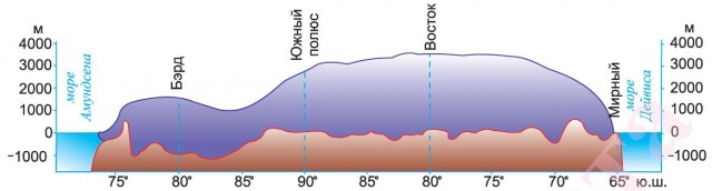
The Antarctic ice sheet hides a highly dissected surface. The under-ice relief is due to geological structure the mainland and the pressure of the glacial shell. According to the nature of rocks and subglacial relief, Antarctica is divided into two parts: Eastern and Western. The mountains of West Antarctica are younger. At the base of most of the mainland (East Antarctica) lies the ancient Antarctic Platform, which was part of Gondwana. The flat relief corresponds to the platform. In the southeast there is the largest of the plains - the Schmidt plateau-like plain, named after the native of Mogilev - academician O. Yu. Schmidt.
The western edge of the platform is bordered by young mountainous regions: the Antarctic Andes and the Transantarctic mountains. They are an extension of the Andes and part of the Pacific Ring of Fire. Mountains in some places rise above the ice sheet. The only active volcano Erebus (3794 m) is located here. The maximum height of Antarctica - the Vinson mountain range (5140 m) - is located in the Ellsworth mountains. In the subglacial relief in the northeast, the Queen Maud Land and the Soviet plateau rise. Mountain ranges are separated by plains (to the north - Western plain, to the southeast - the Eastern Plain, to the southwest - the Byrd Plain).
Antarctica ice sheet
The main feature of Antarctica is the presence of an ice sheet on its surface. The accumulation of the ice mass was compensated by the sinking of the continent, and in some areas, under the weight of the ice, the land sagged 2.5 km below sea level.
The bulk of the ice of the ice sheet in relation to the South Geographic Pole is concentrated in the east of the continent. With respect to the South Pole of Inaccessibility (the point farthest from the coastline of Antarctica), the ice fields are located symmetrically. The location of the South Geographic Pole does not coincide with the South Magnetic Pole, the position of which is determined by the history of the development of the Earth. It is located in the coastal zone in the extreme southeast.
The average thickness of the ice sheet is about 1.8 km, the maximum reaches 4.8 km in the Victoria Land area. Glaciers slide in huge tongues from the center of the mainland to the outskirts and into the sea. Here they break off and form icebergs, which are carried out into the open ocean by winds and currents. Glaciers cover not only the land (ice sheet), but also the continental shelf (ice shelves). Shelf glaciers are a plateau-like mass of ice, an extension of the continental ice sheet in the area of a continental shelf (shelf) with a thickness of 300-350 m. They partially lie on underwater slopes, islands, and partially float.
Among the glaciers, there are outlet glaciers that move inside the continental ice sheet in depressions of the subglacial relief, and typical valley glaciers (in mountainous areas), reaching up to 200 km in length and up to 40 km in width. They move much faster than ice shelves.
About 90% of the fresh water contained in the Earth's glaciers comes from Antarctica. The lakes of the coastal zone are of great importance for the development of Antarctica. In the coastal zone, the water of such lakes is used by the population of scientific stations as drinking water. Small lakes are often temporary and may disappear during the warmer months. In the area of the Vostok station, under the ice sheet at a depth of 3700-4200 m, the largest subglacial Lake Vostok was discovered, which is three times smaller than Lake Baikal.
According to scientists, conditions with increased temperature and colossal pressure are created in ice at a depth of more than 1000 m, where ice melting is possible. This probably leads to the formation of a subglacial hydrographic network, accumulation of water in depressions of the relief. Its existence also results in modern glacial lakes in the coastal zone of the mainland, which periodically instantly descend.
High pressure at the depth of the ice sheet, its movement, as well as processes associated with melting at depth, indicate its mobility and unstable state. These factors, according to scientists, can create conditions for the formation of oil and gas deposits in the Antarctic shelf. Antarctica likely large deposits iron, copper, deposits of rare earth, radioactive and trace elements, as well as non-metallic minerals such as rock crystal, mica, phosphorus, etc.
According to geologists, the bowels of Antarctica contain oil, gas, coal, iron ores, copper, nickel, lead, zinc, gold, silver, uranium, molybdenum, etc. According to scientists, oil and gas deposits on the uninhabited continent are 1.5 times the volume of deposits in the Arabian Peninsula. According to the US Geological Survey, Antarctica's potential oil reserves are estimated at 6.5 billion tons, and natural gas at more than 4 trillion cubic meters.
Almost all of Antarctica lies within the Antarctic Circle. Due to its inaccessible position, Antarctica was discovered by the Russian navigators F. F. Bellingshausen and M. P. Lazarev later than other continents.
The only and unusual continent in its uniqueness of nature. Polar explorers called it icy, silent, deserted, mysterious, white. In winter, Antarctica plunges into the darkness of the polar night, and in summer the Sun does not sink below the horizon, illuminating the icy desert at midnight hours. At the South Pole, the sunrise and sunset can be admired only once a year.
This continent is the highest and coldest. Here are the most strong winds Earth. There is no permanent population here. The ice of Antarctica contains 80% of the planet's fresh water. The history of the discovery and exploration of the continent is peculiar.
Antarctica and Antarctica
The nature of Antarctica is inextricably linked with the nature of the southern parts of the Pacific, Atlantic and Indian oceans and together with them constitutes a single whole. Large areas, shallowly protruding into the land of the seas, are covered with ice shelves. These glaciers are an extension of the continental ice shell.
Antarctic- This is the southern polar region, including Antarctica with the adjacent islands and the southern parts of the oceans up to about 50 - 60 ° S. NS. The name "Antarctica" comes from the Greek word "anti" - against, that is, lying opposite the northern polar region of the globe.
Physical and geographical location
Almost all of the mainland is located within the Antarctic Circle. Antarctica is separated from other continents by vast oceanic spaces. The geographic position of the continent in the pole area has led to the formation of a thick ice cover, the average thickness of which is about 2000 m. Due to the ice thickness, Antarctica turned out to be the highest continent of the Earth. The mainland shores are mostly ice cliffs of several tens of meters. Thanks to its geographical position and ice shell, Antarctica is home to the world's cold pole.
Discovery of Antarctica
First studies. Antarctica was discovered much later than other continents. Even ancient scientists expressed the idea of the existence of the continent in the high latitudes of the southern hemisphere. But the final question about the existence of the sixth continent was. resolved much later. In the second half of the 18th century. an English expedition headed by the famous English navigator James Cook set out in search of the southern continent.
J. Cook crossed the Antarctic Circle more than once, but he could not break through the ice to the mainland. He came to the gloomy conclusion that "the lands that may be in the south will never be explored ... this country is doomed by nature to eternal cold." The results of J. Cook's expedition for a long time cooled the desire to embark on risky voyages in search of the mainland.
Only in 1819 was the first Russian Antarctic expedition organized on the Vostok and Mirny ships under the command of Faddey Faddeevich Bellingshausen and Mikhail Petrovich Lazarev, which went around the unknown continent and came close to its shores, discovered many islands. 1820, when the expedition first approached the shores of Antarctica, is considered to be the year of its discovery, "which marked the beginning of an intensive study of the coastal zone of the southern continent.
On December 14, 1911 by the Norwegian Roald Amundsen, and a month later - on January 18, 1912 - by the Englishman Robert Scott, the South Pole was reached. This was the greatest geographical discovery. Scientists received the first information about the interior regions of the mainland. But they got it at a high price. R. Scott's group died on the way back, not reaching just a few kilometers to the warehouse, where there were food and fuel.
In November 1912, a rescue team found a tent with frozen bodies inside. Near the tent stood a sled with a geological collection weighing more than two poods.
Modern Antarctic Research
Exploration of Antarctica by Soviet scientists. In the first half of the XX century. The USA, Great Britain, Australia, Norway and other states have organized special expeditions to study Antarctica. Each country pursued its own goals and acted alone. Research was carried out mainly on the coast, while the interior regions of the mainland remained little known.
Only in connection with the International Geophysical Year (IGY, 1957 - 1958), twelve states of the world decided to jointly explore the continent and exchange information. One of the leading places in this work was taken by Soviet Union... Soviet expeditions were organized at a high scientific and technical level. For their implementation, a rich practical experience in the study and development of the Arctic was used. Despite the fact that the Soviet Union had no scientific stations and no experience of work in Antarctica before the beginning of the IGY, our researchers boldly moved deeper into the continent.
In difficult climatic conditions, in a short period of time, they built several scientific stations (Mirny, Pionerskaya, Vostok, etc.) not only on the coasts, but also in the inner hard-to-reach parts of Antarctica, where no man's foot has yet set foot (Pole of Inaccessibility). The main and largest at this time is the Molodezhnaya station. Here is the Antarctic Aerometeorological Center.
For more than three decades, Soviet specialists have been successfully working, a lot of scientific material has been collected, many works have been written, the first Soviet Atlas of Antarctica has been created. On it you can get information about all components of the Antarctic nature. Hundreds of names of Russian and Soviet explorers are immortalized on the map of Antarctica.
Antarctica differs from other continents not only by the absence of a permanent population, but also by its legal status. It does not belong to any state. According to an international agreement, it is prohibited to carry out any military measures, testing of weapons and nuclear explosions on its territory. The law provides for the protection of the Antarctic nature.
And it is no coincidence that Antarctica is called the continent of science and peace. Thanks to well-organized international cooperation and hard work of scientists, many secrets of Antarctica have now ceased to exist. by Abramenko
Ice sheet
How much ice is in Antarctica? What is under the thick ice sheet? Even 30 - 35 years ago, these questions could not be answered with confidence. Scientists have established that the Antarctic Platform lies at the heart of most of the continent - in its eastern half. Almost the entire continent is covered with an ice sheet, the average thickness of which is about 2000 m, and in the eastern part the maximum thickness reaches 4500 m.
The average height of the continent, taking into account the ice sheet, is 2040 m. This is almost 3 times higher than the average height of other continents. The ice sheet of Antarctica contains about 80% of all fresh water on Earth. The ice sheet resembles a dome, raised in the central part of the mainland and descending towards the coast, gradually spreading towards the periphery.
Ice relief
Modern research methods have made it possible to obtain a clear understanding of the subglacial topography of the continent. About 1/3 of its surface lies below ocean level. At the same time, mountain ranges and massifs were discovered under the glacial shell. From the Weddell Sea to the Ross Sea, along the fault zone, stretch the Transantarctic Mountains, which separate West Antarctica from East Antarctica, which differ greatly in relief.
West Antarctica is highly dissected. Along the Antarctic Peninsula and the western edge of the mainland, there are mountains that serve as a continuation of the Andes of South America. Here is the highest mountain range of the mainland (5140 m), the deepest depression (- 2555 m). Most of the mountains are covered with a continental glacier, and only in some places their highest peaks freakishly rise above the icy desert. Lavas rising along fault lines play a significant role in the structure of the mountains.
In East Antarctica, under a continuous ice cover, flat areas of the surface alternate with mountain ranges 3000 - 4000 m high. They are composed of ancient sediments, similar to the rocks of other continents that were part of the ancient continent of Gondwana.
The features of the glacial and subglacial relief of East Antarctica are clearly visible on the profile of the Antarctic surface compiled by Soviet polar explorers during the expedition of the sledge-caterpillar train along the Mirny - Pole of Inaccessibility, Mirny - South Pole route. On the outskirts of the mainland, on one of the coastal islands of the Ross Sea, the active volcano Erebus rises - a witness to active mountain-building processes in this area.
Almost all of Antarctica is located in the Antarctic climate zone. This is the coldest continent of the Earth. The climate is especially harsh in the interior regions of the continent. The average daily temperature there, even in summer, does not rise above - 30 ° C, and in winter it is lower - 70 ° C. Antarctica is called the "refrigerator" of the Earth. The southern hemisphere, due to its influence, is much colder than the northern one. Soviet polar explorers at the Vostok station recorded the lowest temperature on Earth (-89.2 ° C). That is why the Vostok station is called the Pole of Cold of the Earth. At such a low temperature, the metal becomes brittle and upon impact shatters like glass, and kerosene thickens and can be cut.
From severe frosts, people have had cases of frostbite of the lungs and cornea of the eyes. Therefore, to work in such conditions, you have to use special clothing. Antarctic air is surprisingly clear and dry.
In the summer, Antarctica receives more solar heat than the equatorial region of the Earth. But 90% of this heat is reflected by snow and ice. Moreover, the summer is very short. On the coast of the mainland it is much warmer, in summer the air temperature rises to 0 ° С, and in winter there are moderate frosts. In areas where there is no ice cover in summer, the rocks absorb up to 85% of the sun's heat, heat up themselves, and heat the surrounding air. Oases are formed here. In the oases, the temperature in summer is much higher than above the surrounding glaciers. They are real hotbeds.
The southern parts of the three oceans adjacent to Antarctica are located in the subantarctic belt. Temperatures are higher here than over the mainland. Due to the large difference in temperature and atmospheric pressure over the inner regions of Antarctica and over the oceans that wash the mainland, constant winds blow from the mainland in the coastal strip. Towards the shore, they intensify and sometimes reach hurricane force. These winds blow huge amounts of snow from the mainland into the ocean.
In winter, the seas are covered with solid ice. In summer, the edge of solid ice recedes almost to the very coast. The mainland ice sliding into the water breaks off and forms huge icebergs. Currents carry them far into the ocean.
In the distribution of precipitation, as well as in temperature, zoning is well expressed. The central parts of the mainland receive from 40 - 50 to 100 mm per year, like the Sahara.
Flora and fauna
Most of Antarctica is devoid of flora and fauna. This is the Antarctic desert. Modern organisms of Antarctica are represented by mosses, lichens, microscopic fungi and algae, etc. Plants grow in areas free from the ice sheet, even near the Pole. The oases of Antarctica can be seen as hotbeds of life in the icy desert. The lakes of the oases are rich in a variety of algae. Bacteria were found in the snow near the Pole of Cold.
The fauna is associated with the oceans washing the mainland. The waters of Antarctica are rich in plankton, which is a food source for whales, seals, fish and birds. Several species of cetaceans are found here, among them the largest animals on our planet are blue whales, as well as sperm whales and killer whales. Pinnipeds are widespread.
There are several types of penguins. The most common is the small Adélie penguin. Especially beautiful are the emperor penguins, weighing up to 50 kg and more than a meter high. They hatch their offspring in a harsh winter, without making nests, and keep their eggs in their paws, pressing their warm belly to the fluff. Antarctic and snow petrels nest high in the mountains. On the coast in summer you can see cormorants and skuas. Skuas are very peaceful, they accompany polar explorers; eating edible waste, they play the role of orderlies.
Practical and scientific significance modern Antarctic research. Research in Antarctica is taking place under extremely difficult conditions. What explains the huge interest in the study of the icy continent?
Various minerals were found in its depths: coal, iron ore, non-ferrous metals. Found traces of oil, natural gas. Scientists suggest that there is gold, diamonds, uranium. The oceanic waters of Antarctica are rich in large marine animals, fish, crustaceans. Whales, especially the largest blue whale, have been significantly exterminated and have been under protection since 1967. Antarctica contains huge reserves of fresh water. There are now projects to tow icebergs to countries suffering from lack of icebergs.
The study of Antarctica has not only practical but also scientific value. The processes taking place in Antarctica inevitably affect the nature of the surface of the entire Earth. For example, changes in the level of the World Ocean largely depend on the behavior of ice (accumulation of ice, change in speed, melting). The atmosphere over Antarctica affects the movement of the air masses of the entire planet.
The ice sheet, which arose 20 million years ago, contains rich information about secular climate fluctuations, as well as about the history of the development of natural complexes on the Earth.
a series of lessons on the topic: "Antarctica".
Prepared by: Geography Teacher
MBOU Secondary School No. 45, Lipetsk
Meshcheryakova Olga Nikolaevna
Lesson objectives:
To form ideas about the originality and
the uniqueness of the nature of the continent, the role of scientists
in the discovery and exploration of Antarctica;
Promote idea formation
cognition of the world, development of skills and
students' skills in working with different
sources geographic knowledge
(contour maps, atlases, textbooks,
encyclopedic, reference material,
different types of cards), skills to work in
groups.
"At the edge of our planet lies like
sleeping princess, earth chained
in blue. Sinister and beautiful she
lies in its frosty slumber, in
the folds of the mantle of snow, glowing
amethysts and emeralds of ice. She
sleeps and her horizons are colored
pink, blue, golden and
green tones ... "
So English Wrote in 1947
scientist, researcher - A. Richard
Bere about the mainland with which we
let's get acquainted in the lesson.
Antarctica lies in the extreme south of the planet and
therefore the name of the mainland comes from the Greek
the words "anti" - against, that is, lying against the north.
Its area is 14 million square kilometers. She
almost entirely located within the South
polar circle. In relation to the initial
meridian, most of Antarctica lies in
eastern hemisphere. In the western part of the mainland
there is a large peninsula - Antarctic.
The extreme point of the mainland is Cape Sifre,
located on the Antarctic Peninsula, 63
degrees south latitude. The shores of the continent
represented by glacial cliffs. Quiet,
Indian, Atlantic oceans form at
Antarctica is a shallow sea protruding into the land.
Which?
Task number 1
Show on the map of Antarctica South
polar pole, South Arctic Circle,
prime meridian. Determine which
continents on the map are close to
Antarctica? And how is the description of the GP given
Antarctica in various sources?
Do you think that G.P.
mainland to the nature of Antarctica.
′
′
Antarctica was officially opened on January 16 (28), 1820
Russian expedition led
Thaddeus Bellingshausen and Mikhail Lazarev, who are on sloops
"Vostok" and "Mirny" approached it at 69 ° 21 S. NS. 2 ° 14 W etc.
(area of the modern Bellingshausen ice shelf).
Earlier existence southern mainland was approved
hypothetically, it was often united with South America
(for example, on a map compiled by Piri Reis in 1513) and
Australia
(and named after the "southern continent").
However, it was the Bellingshausen and Lazarev expedition to
South polar seas, circling the Antarctic ice around the world,
confirmed the existence of the sixth continent.
The first to enter the continent was probably the team of the American
ship "Cecilia" on February 7, 1821. Exact drop off location
unknown, but believed to have occurred at Hughes Bay
64 ° 13 S NS. 61 ° 20 W This is a continent landing application
are among the earliest. The most accurate is the statement
about landing on the mainland (Davis Coast) from a Norwegian businessman
Henrik Johann Bull, dated 1895.
′
′
Climate, vegetative and
animal world
Antarctica is rightfully considered the coldest continent
on the planet: in winter, the temperature drops below -90 ° C, and in
summer "heat" the maximum mark on the thermometer is -20 ° С.
It doesn't rain here and all the rain falls
exclusively in the form of snow.
In the central part of the mainland, the weather is all year round
calm, clear and dry, and snowstorms reign on the shores,
winds up to 90 m / s and dry snowfalls.
The predominant part of Antarctica is devoid of life - in the ice
no living creatures can survive in the desert. Only in
coastal oases, occupying only 0.02% of the territory,
life glimmers - lichens, rare mosses, algae grow.
Penguins live in the waters of the Southern Ocean near the mainland,
whales and seals. Interesting fact turns out to exist
17 kinds of penguins! The largest of them is the imperial
penguin.
Think why Antarctica
has such a harsh climate? WITH
what is it connected with?
Leopard seals
seal) - a variety of seals,
habitat of which
are subantarctic
areas of the Southern Ocean. Males
leopard seals in length
reach 3 meters and weigh
about 270 kg, and females
grow up to 4 mi have mass
bodies up to 0.4 tons. Animal body
has a smooth, streamlined
form enabling
slide unhindered into
thicker ocean waters with
speed up to 40 km / h. In the diet
the nutrition of these animals includes
warm-blooded vertebrates, including
including juvenile seals and penguins.
Geographical location of Antarctica
The geographical position of Antarctica is unique - there is no longer a single continent on Earth that would be completely located in the polar region of the planet. This arrangement led to the emergence on the mainland of a permanent cover glaciation and very heavy climatic conditions... The area of Antarctica is 14 million km2. Due to the peculiarities of the location, it is not necessary to talk about the length from north to south and from west to east, however, the maximum distance between two opposite points of the coast is about 5700 km. In the very north, the continent is crossed in several places by the South Arctic Circle.
From extreme points the mainland can only be called the northern one: Cape Sifre (63 ° 12 "48" S, 57 ° 18 "8" E) on the Antarctic Peninsula.
The mainland is located in the sub-Antarctic and Antarctic climatic zones of the Earth.
Antarctica is washed by the Southern Ocean. Otherwise, if this ocean is not considered, it is washed by the waters of the Atlantic, Indian and Pacific oceans.
The mainland occupies an extreme southern position, is not connected to any of the other continents, and is also most distant from the rest.
Antarctica is a territory that includes the mainland Antarctica and the adjacent Antarctic waters (southern margins of the Pacific, Atlantic and Indian oceans) with islands up to 48-60 ° S. NS.
Antarctica is icy, desert and coldest continent. It is located in the southern polar region of the Earth; therefore, all its shores are northern. Most of the territory lies in the Eastern Hemisphere. Antarctica is significantly removed from the inhabited land. The distance to the nearest mainland, South America, is over 900 km (Drake Passage). Coastline Antarctica is mainly formed by the edges of a glacier, which breaks off with a wall of several tens of meters into the ocean. Only one peninsula stands out - the Antarctic.
Natural conditions and resources. Relief and minerals. From space, Antarctica resembles a plain. But this is an unusual "plain" on Earth. Its average height above sea level is 2040 m, which is almost three times the average height of all continents. A feature of this "plain" is that its surface is covered with a thick layer of compressed ice, which reaches 4000 m in the central part, forming a kind of dome. Its ice spreads from the center of the mainland to the edges, forming icebergs. The glaciers of Antarctica contain 80% of the Earth's fresh water.
The ice shell hides complex tornado structures, plains and deep depressions underneath. At the root of the continent lies the ancient Antarctic platform, which was part of Gondwana, is Eastern Antarctica; The western (folded region) includes the Transantarctic Mountains - an extension of the Andes. In some places they protrude to the surface. Highest point mainland - Mount Vinson (5140 m). On the shores of the Ross Sea is the active volcano Erebus.
Deposits found in the bowels of Antarctica coal and iron ore, as well as signs of deposits of gold, uranium, copper, nickel, lead, silver.
Climate. The peculiarities of the geographical position and the ice sheet have led to the formation of a harsh climate, the coldest on Earth. Polar explorers of Vostok station noted the most low temperature-89.2 ° C. Cold and dry Antarctic regions form over the mainland. air masses... Constant katabatic winds blow from the high ice dome, reaching hurricane speeds of up to 80 m / s. Winters are especially harsh in Antarctica. average temperature-70 ° C in winter. Summer temperatures in the interior rarely rise above -36 ° C. Precipitation in the central part of the continent falls less than 100 mm, and they fall only in a solid state. The climate of the coastal part is different. Strong winds are frequent here, the amount of precipitation increases (up to 300 mm), summer temperatures are higher (-1.0 ° С), there are rains. There are two climatic zones on the continent: Antarctic and subantarctic.
The organic world is poor compared to other continents. The vegetation of the mainland - mosses, lichens, algae, microscopic fungi.
The centers of life in the icy desert of the mainland are oases (ice-free places). The fauna is richer and more varied than the flora. The life of most animals is associated with the ocean, there are few land animals. There is a lot of plankton in the coastal waters, which feeds on fish, whales, and seals. Most typical birds Antarctica - penguins. Even far from the coast, in the mountains, you can find nesting birds (petrels, skuas, gray gulls).
Natural resources: iron ore, chromium, copper, gold, nickel, platinum and other minerals; small reserves of coal and hydrocarbons were discovered (currently not being developed); krill, fish and crabs are industrial fisheries
Definition: This indicator contains information on natural resources, reserves of mineral raw materials, energy, fish and forest resources.
Geographical position of Antarctica - concept and types. Classification and features of the category "Geographical location of Antarctica" 2014, 2015.