To study the nature of continents and oceans, geographers use general geographic and sectoral methods research.
Some of the main research methods in geography are observation and dimension, thanks to which they collect primary geographic information about the features of continents and oceans. Direct observations and necessary measurements are carried out during expeditions, staying directly at the object under study, for example, at a scientific station in Antarctica. They are often carried out from research ships or even from regular ships, from orbits. space stations and geophysical rockets, with artificial satellites Land and aircraft laboratories (Fig. 4).
Space observations have enriched geography with new knowledge. During observations of the ocean near Antarctica with the help of a satellite, for the first time, they noticed ocean eddies with a diameter of 30 to 200 km and determined that they are similar to cyclones and anticyclones of the atmosphere. With the help of satellites, the movements of lithospheric plates were recorded, reaching approximately 10 cm per year. Thanks to the survey of the ocean floor by spacecraft, they discovered the differences in the relief of the ocean floor in comparison with the land surface and created the corresponding maps.
On the basis of the received primary geographic information, layouts, or models (Fig. 5), of relief forms, cyclones and anti-cyclones, rivers with a dam and a reservoir are created, natural complexes and others, develop various maps.
In geography, there are also methods for obtaining secondary geographic information. This is due to the fact that many geographic objects are inaccessible for direct observation or are very large in size. Then research scientists resort to using previously obtained and ordered data.
Scientists accumulate secondary geographic information gradually. Sources of information for them are maps, especially thematic ones, analyzing which you can compare phenomena, create an image specific territory (Fig. 5). Orderly geographic information is given and tables, combining various characteristics of the territory. An example of such a table is the geochronological scale. The source of secondary geographic information is graphs, diagrams, profiles.(Remember what kind of graphs of temperature changes, wind rose, climate diagrams, relief profiles have.)
An important method of obtaining secondary information in geography also remains descriptions, especially when it comes to the characteristics of the nature of individual continents, countries, mysterious seas and islands. Nowadays, the function of description is also performed by various video media - cinema and television.
A new source of secondary geographic information is geographic information system (GIS), designed for computer reading, analysis and information provision. Material from the site
GIS is fast. In GIS, there is a certain set of programs that help to quickly (in 3-5 minutes) create any geographic map. At the same time, the necessary data is entered, and their analysis is carried out automatically. And when working with atlas maps, when it is necessary to find a certain relationship, for example, between relief and structure crust, time is used five times more, because you need maps of different scales located on different pages.
On this page material on topics:
Lecture on the topic: geographical map - a source of information
Sources of geographic information report
Geographic information material
A post on geography on the latest sources of geographic information
Observation method in geography
Questions about this material:
Methods geographic research- ways of obtaining geographic information. The main methods of geographical research are:
1) Cartographic method... The map, according to the figurative expression of one of the founders of the Russian - Nikolai Nikolaevich Baransky - is the second language of geography. The map is a unique source of information! It gives an idea of the relative position of objects, their size, the extent of the spread of this or that phenomenon, and much more.
2) Historical method... Everything on Earth is developing historically. Nothing arises from scratch, so for knowledge modern geography knowledge of history is necessary: the history of the development of the Earth, the history of mankind.
3)Statistical method... It is impossible to talk about countries, peoples, natural sites without using statistical data: what is the height or depth, the area of the territory, reserves natural resources, population size, demographic indicators, absolute and relative indicators of production, etc.
4) Economics and Mathematics... If there are numbers, then there are calculations: calculations of population density, mortality and population, balance, GDP per capita, etc.
5) Method geographic zoning ... Allocation of physical-geographical (natural) and economic regions- one of the research methods geographical science.
6) Comparative geographical... Everything is subject to comparison:
more or less, profitable or disadvantageous, faster or slower. Only comparison makes it possible to more fully describe and evaluate the similarities and differences of certain objects, as well as explain the reasons for these differences.
7)Field research and observation method... Geography cannot be studied only while sitting in classrooms and offices. What you see with your own eyes is the most valuable geographic information. Description of geographical objects, collection of samples, observation of phenomena - all this is the factual material that is the subject of study.
8) Remote observation method... Modern aerial and space photography are great assistants in the study of geography, in creation, in development National economy and nature protection, in solving many problems of mankind.
9) Geographic modeling method... Geographic modeling is an important method of geography research. The simplest geographic model is.
10) Geographic forecast... Modern geographical science should not only describe the objects and phenomena under study, but also predict the consequences to which mankind may come in the course of its development. Geographic forecasting helps to avoid many undesirable phenomena, to reduce the negative impact of activities on nature, to use resources rationally, and to solve.
For a long time, a person was interested in what is beyond the horizon - new territories or the end of the earth. Centuries passed, civilization accumulated knowledge. The time has come when scientists, who have never been to distant lands, knew a lot about them. In this they were assisted by sources of geographic information.
This article will tell you about what it is, as well as about their varieties.
General concepts
As you might guess, this is the name of all of which a person can get information of interest to him. What sources of geographic information are considered by grade 5 (in secondary school)? Let's list them:
- Everything geographic Maps, atlases, as well as a variety of topographic plans, including military ones.
- Diverse geographical descriptions specific area.
- Reference books, encyclopedic articles, results and reports of various expeditions.
- Aerial and satellite imagery of the area.
- GIS and GPS / GLONASS systems.
These are the sources of geographic information in grade 5 in an average general education school. We will try to consider the characteristics of some of them in a little more detail.
Modern technologies
V last years more and more sources are being converted from paper to digital. And this is not surprising. Almost all 5 sources of geographic information that we have just talked about today can be found in digital form. Even professional scientists in recent years prefer to work with digital.
 The same GIS system is much more convenient to work with than with a pile of books. Now let's discuss some sources of geographic information in more detail.
Cards
A map is a schematic generalized image of the surface of a piece of the earth, the entire planet or celestial bodies. It is built on the principle of scaling, that is, mathematical methods are used for this. Depending on the scale, it is customary to subdivide all maps into three large groups:
- Large-scale.
- Medium Scale.
- Small-scale.
If we talk about the first category, then these documents may have a ratio of 1: 200,000 and larger. This includes almost all topographic plans. Small-scale maps are considered all maps with a ratio of less than 1: 1,000,000. A typical geographic atlas includes either small-scale or medium-scale maps that are best suited for the study of a particular area.
Sorting cartographic information
You should be aware that long before the creation of the map, experts make a strict selection of what will be depicted on it. This process is called as follows: cartographic generalization. Naturally, the most stringent selection exists for small-scale maps, since they need to accommodate the maximum volume useful information with the minimum required area of the document. In the generalization itself, an extremely important role is played by the direct purpose of the card, as well as the wishes of its customer.
Site plans
 This is the name of the terrain drawings, which are carried out in large scale(1: 5000 and more), and they are drawn using special legend... In this they resemble a school geographic atlas. The construction of such plans is carried out on the basis of eye, instrumental measurements, aerial photography, or a combined method.
Since the plans indicate relatively small areas of the earth's surface, when creating them, the curvature of the planet can be neglected. It should be clearly understood that these sources of geographic information that we have just described are fundamentally different from each other.
The main differences between plans and maps
- In a centimeter of the plan, more than five real kilometers on the ground are rarely laid. They are much more detailed than maps, in one millimeter of which hundreds of kilometers of the earth's surface can be laid.
- All objects on the ground in the plans are depicted in maximum detail. In principle, all more or less significant areas are marked on the average drawing. So, on the topographic plans of the General Staff of the Armed Forces of the Russian Federation (and the USSR, of course), even trees and small streams can be displayed. It is impossible to fit all this information onto maps. Actually, this is why generalization, which we talked about above, is being carried out. Even the exact outlines of continents cannot be displayed on many maps, and therefore they are often plotted with significant distortions. In addition, the geography supplementary literature described above uses off-scale conventions.
- We emphasize once again that when constructing a plan, the curvature of the earth's surface is neglected. Maps, especially on a small scale, take it into account without fail.
- There is never a degree grid on the plans. At the same time, there are parallels and meridians on each of them.
- The plan is always easy to navigate. The top of the document is north, the bottom, respectively, is south. On maps, the direction is determined by the parallels.
Methods for depicting objects on plans and maps
 Conventional signs in this case are generally accepted options in which the characteristic of objects depicted on a map or plan is encoded. With their help, you can display both something concrete (a mountain, for example), and something completely abstract, conditional (population density in a city, village, etc.). Of course, they all make life much easier for a person who knows the basics of cartography and can read these drawings.
How long does the card remain valid?
Almost all geographers and geologists ask this question at least once in a while. The specific answer to it depends on the purpose, scale, and author of the plan. For example, medieval researchers often drew maps literally on their knees, so there is no need to talk about their accuracy. But the maps of the General Staff, despite the time, are still striking in their accuracy.
Do not forget that the cards are quite stable, while the plans of the Amazon and the Nile can be safely thrown away fifty years after their publication. These rivers so effectively and quickly change the relief of the Earth's surface that older documents are useful only in a historical perspective.
Geographical descriptions, discoveries
All the sources of geographic information discussed above are somewhat dry and uninteresting. It is much more exciting to read the description of a region, locality or even the mainland, written by the person who discovered all this!
All jokes, but descriptions and reports on geographic (geodetic, biological) research can sometimes give much more information than the most detailed topographic plan of the area. Moreover, the latter does not reflect some unpleasant features of a particular area (malaria, which occurs in some central regions of Africa at every step, for example).
 The list of geography literature that students are given at school (for example, Nikolina V.V. Geography, Lesson development; Samkova V.A.We study forest; Forest encyclopedia: in 2 volumes / chief editor G.I. Vorobyov ), just the same, and was formed thanks to the works of researchers, who at one time entered all this information on the map, being in the thick of things.
Brief information about the discovery of Africa
Let's tell a little about the history of the discovery of the Black Continent. Of course, the word "discovery" is not entirely correct here: here is Australia - yes, I had to suffer with it. In the case of Africa, the coastal regions were perfectly explored, where they caught black slaves and bought ivory from Arab traders, but almost no one knew about what was happening in the interior of the continent.
Everything changed in the 19th century, when the legendary arrived in Africa.It belongs to him the honor of discovering the sources of the Nile and the magnificent Lake Victoria. Few people know, but research Central Africa at one time the Russian scientist V.V. Juncker studied (in 1876-1886).
For the indigenous population of the mainland, all this ended sadly: the main sources of geographic information (that is, maps), the data for which with such difficulty and constant danger to life were collected by all these brave scientists, began to be actively used by slave traders ...
So, with the maps and plans, we are actually finished. Geographic atlases fall into the same category. What is the role of modern sources of geographic information? To answer this question, let us consider the principle of joint use of old paper maps and a navigator, which even professional geographers and geologists are now actively using.
GPS / GLONASS + maps
 It should be noted that this method is excellent for determining the accuracy of maps, atlases and topographic plans. In addition, this methodology meets the needs of historians, since they can personally see how much the area has changed, which is described in historical chronicles by contemporaries of certain events. However, the literature on geography often contains site plans that have not been updated since the beginning of the last century.
To use such an accurate, but rather laborious and somewhat extravagant method, you will have to perform a threefold binding (three different maps) to the same area of the terrain:
- First, find a more or less modern map or topographic plan.
- It is advisable to have a fresh aerospace image of the surveyed area with a topographic reference to the coordinate system.
- Finally, you need the card, the information of which you are going to check.
The point of this operation is to enter all three of these terrain drawings into the navigator's memory. Modern models of such devices have a powerful enough processor and an impressive amount of RAM, so you can instantly switch between cards.
Determination of the route to follow
Route planning is best done using modern map or topographic plan. We do not recommend using old documents for this. It is quite possible that on the site of the swamp there is now a passable terrain, but you will no longer be able to walk along the edge of the once rare young forest, since the geography of the area has radically changed. A map is good, but in most cases such documents are not very accurate.
Why aerial photography and satellite imagery are preferable to maps?
But why are paper drawings so inferior to products of modern technology? There are two reasons for this:
- First, the relevance of space imagery or aerial photography is much higher in most cases. When else will cartographers be honored to carry out the next generalization of new data and release up-to-date terrain plans?
- In the pictures, you can literally in real time be able to determine the characteristics of a particular area. On a map or even topographic plan tree species in the forest will be displayed only schematically and only in general order. Simply put, it is quite possible to stumble upon a dense spruce forest in the middle of a birch forest, but in a dense coniferous forest it is much easier to get lost.
Having chosen a route and having checked the new pictures, it is recommended to contact old map... Why are there such difficulties? Imagine you are a field biologist. You need to determine how much the forest has grown, what new tree species have appeared, how many types of forest have changed over the years. Ideal for all these tasks is a simple overlay of a new card on its old counterpart. Thus, everything becomes visible as clearly as possible.
 Here are the sources geography uses. The map is perhaps the most important of them, but one should not forget that over the past decades, science and technology have made a huge step forward, and therefore it is foolish not to take advantage of all modern achievements.
Conclusion
So you have learned which sources of geographic information are currently the most relevant. Oddly enough, but we still use all the same plans and maps that were invented before our era. Of course, adjusted for their modern look.
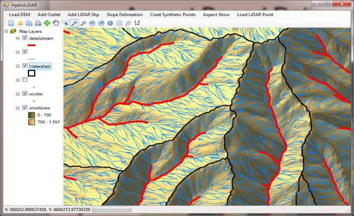
Geographic information systems. Geographic information is constantly used in management, planning, forecasting and socio-economic development, everyday life. Based geographical bases data (DB) are formed by geographic information systems (LS) - created using a computer "storage" geographic knowledge O territorial organization and the interaction of society and nature. PS is an automated system for storing, analyzing, presenting spatial data in the form of text, tables, graphs, maps (Fig. 2). The PS includes: computers, software, spatial information in the form of cartographic data on natural components, economy, land, roads, etc. They are automated systems that operate on spatially coordinated information. The functioning of the PS is carried out in the following sequence: collection and automated processing of geographic information, its spatial referencing and presentation in the form of an electronic map on the display screen, translation of this map into paper form if necessary (for example, creation of atlases).
By the size of the covered territories, PS are divided into global, national, regional, local, and local. They are used to compile geographical maps, cadastres of natural resources, engineering surveys and design, the formation of management decisions, they are also distinguished by individual objects and areas of research: geographical, environmental, land, property, forest management, water resources, recreational, tourism, etc.
The Institute of Geography of the National Academy of Sciences of Ukraine is developing a multipurpose National SS of Ukraine, the purpose of which is to create a geographic-cybernetic model of the region. In Kiev national university named after Taras Shevchenko researches automated cartographic systems based on digital maps, volumetric computer models of modern urban landscapes of Kiev.
An important component of the aircraft is aerospace information, data from aerovisual observations, ground sensors, etc. Such aircraft are called integrated. Their databases combine cartographic data with remote sensing images of the Earth's surface, they have blocks for receiving and programs for processing aerospace materials. PS databases are formed from many sources of geographic information. These include textbooks tutorials, maps and atlases, scientific reports on the results of geographical research, statistical reference books to data on the development of the country's economy, encyclopedias, dictionaries, the results of geographical research published in books, scientific journals, observation data carried out by institutions of state services: geological and hydrometeorological, geodesy, cartography and cadastre, other agencies and departments.
Geographic research. An important source of geographic information is expeditionary research, travel, local history excursions, tourism, mountaineering. Field expeditionary research is expeditionary and stationary. Expeditionary is the study of individual natural components, sectors of the economy (geomorphological, hydrological, geobotanical, oceanic), which cover large areas and water areas). Natural and household complexes and regions are cognized in the process of comprehensive geographical research (natural-geographical, landscape-science, economic-geographical, natural-resource, nature conservation). Expeditionary research is carried out by teams of scientists according to specially developed programs and methods and is divided into three periods: preparatory, field expeditionary and cameral (processing of collected materials, writing a report, drawing up maps). During expeditionary research, aero space images the earth's surface, made of aircraft and spacecraft. Aerospace images are decoded - they recognize objects reflected on them by their shape, color, and image tone. A look at the Earth from Space encompasses it
big tectonic structures, deserts, river basins, areas inaccessible for land expeditions. Satellites provide an opportunity to study the dynamics and frequency of natural processes, unique phenomena and objects (volcanic eruptions, fires, avalanches, landslides, faults in the earth's crust, atmospheric pollution, etc.). From cosmic heights a new world, hitherto unknown to us, new regularities opens natural conditions, features of urbanization, temperature inhomogeneities in the seas and oceans, forests.
Rice. 2. General scheme of PS functioning
In 1995, the first Ukrainian satellite "Sich-1" was launched, equipped with devices for remote sensing of the Earth, inventory and assessment of lands, prospecting for minerals, meteorological forecasting, condition monitoring the environment... Ukraine cooperates with space agencies of the European Community, Russia, Germany, France, Latin America on space exploration of natural resources and nature protection. The Center for Aerospace Research of the Earth, the Center for Radiophysical Sounding of the Earth, and the Marine Hydrophysical Institute function in Ukraine.
They receive geographic information about natural and man-made processes, changes in the natural environment, geochemical anomalies, cities and suburban areas, atmospheric pollution, flooding, quarries, abrasion, the state of vegetation, areas of radioactive contamination, emissions from treatment facilities, etc.
Stationary geographic research has been carried out regularly over the years at specially equipped geographic stations. They study in detail the changes in natural complexes over time. In Ukraine, such scientific complex physical and geographical research was started by Academician G. Vysotsky at the Velikoanadolsk station to study the influence of hydroclimatic and soil conditions on afforestation in the steppe zone of Ukraine. Stationary geographical research is carried out at the bases of the Institute of Geography of the National Academy of Sciences of Ukraine, Kiev, Lvov, Odessa, Kharkov, Tavrichesky universities.
Observation of the state of the atmosphere and the hydrosphere is carried out at hydrometeorological stations and posts where young specialists in meteorology and climatology, hydrology and hydroecology, and oceanology work. More than 5,000 employees work in the institutions of the Hydrometeorological Service of Ukraine. There are about two hundred hydrometeorological, aviation, aerial and agrometeorological stations in Ukraine. Observations are carried out on the condition of rivers, lakes, reservoirs, sea estuaries at 400 hydrological posts. Along with them, agrometeorological indicators are recorded at 150 points, ozonometric, radar studies of the formation of clouds, precipitation, pollution of the atmosphere, water, and soil are carried out.
Our state has membership in the World Weather Watch, the World Meteorological Organization. Hydrometeorological conditions are important economic and social factors: the social and economic state of the state, the ecological situation, the agro-industrial complex, energy, transport, utilities, military security, and recreation depend on them. Sources of geographic information are local history studies and descriptions of the native land, cities, and other settlements... They also serve as descriptions of travel, tourist and mountaineering routes, excursions.
The essential components of geographic information are maps and atlases. Maps is the second language of cartography. Cartographic images convey, reproduce the sizes and properties of geographic objects using geographic means and signs (lines, points, shapes) and a colored background. Combinations of graphic signs and background are means of cartographic modeling, creation of cartographic images (geo-image). To understand the natural and economic objects displayed on the map, components of natural conditions, processes, patterns of their distribution, legends are attached to the maps. The legend text, geographical names, terms and concepts allow you to "read" the map, use it, and find new facts on it.
Maps are the most important components of the information building blocks of geographic atlases. Geographers and cartographers have significant experience in compiling complex and industry-specific, scientific, reference and educational atlases. National atlases are becoming extremely important. By the Decree of the President of Ukraine L.D. Kuchma on 01.08.2000 "On the National Atlas of Ukraine" a new cartographic work is being created - the National Atlas of Ukraine. It will reflect the spatial characteristics of natural conditions and resources, population, economy, environmental conditions, science and culture of Ukraine. National atlases are integral cartographic models of states as natural resource and socio-economic territorial systems. The National Atlas of Ukraine should provide geographic information to the state, its regions and their governing bodies, scientific, educational, design, production and public institutions, to help disseminate geographical knowledge about our state, to promote its cooperation with other countries of the world.
Geographic information is produced by the Institute of Geography, the Institute of Geological Sciences, the Institute of Botany, the Institute of Zoology, the Research Council productive forces Ukraine, regional natural science and socio-economic divisions of the National Academy of Sciences of Ukraine. Various geographical information is kept by the National Natural Museum of Ukraine, regional and district, city local history museums. Geographic research is carried out by scientific laboratories of universities, scientific departments of natural and natural-historical reserves, national natural parks, biosphere reserves... Various geographic information is available in statistical reference books, dictionaries, encyclopedias, scientific journals, and periodicals. The results of scientific research, descriptions of travel, regions of Ukraine and the world are given in the "Ukrainian Geographical Journal" (founded in 1992 p.), The Journal "Geography and Foundations of Economics at School" (published since 1995 p.), Weekly "Regional Studies. Geography. Tourism "(published from J996 p.), scientific bulletins and collections, which are published by scientific institutions, universities, reserves, printed as materials of scientific conferences, geographical congresses, etc.
The media are filled with geographic information: newspapers, radio and television broadcasts. Geographic popular science, documentaries, educational films are being created. The Internet provides great opportunities for obtaining and using relevant geographic information. We find descriptions and pictures geographic in terms of content in popular science and fiction, paintings, landscape architecture, etc.
1 ... Geographic research methods and main sources of geographic information.
Geography - ancient science, which originated at the dawn of the development of human society. The first geographical representations were based on the simplest method still in use today - the method visual observations.
In the process of development of geographical science, many types of observations were formed: route and area, continuous and periodic, stationary and remote, etc.
These methods provide important information about geographic sites, their properties, changes under the influence of various factors.
The main language of geography, the source of geographic information has been and remains geographic maps The role of maps and cartographic method in the knowledge of the world it is difficult to overestimate.
The cartographic method makes it possible to study the patterns of spatial distribution and development of territorial complexes by compiling and using geographical maps.
The development of geography has fundamentally changed the appearance of the map. The oldest board cards were replaced by images on skins, wood, and clay products. Then came handwritten paper maps, later printed engravings, and now electronic video images and their color copies. The emergence and development of electronic technology made it possible to create geographic information systems.
Such systems use extensive statistical material, receive data from satellites and numerous weather stations. Geographic information systems include databanks containing reports on the results of the work of many research teams.
In the 20th century, geography began to play an important role aerospace techniques. They provide the ability to explore and map earth surface using aircraft or spacecraft. Aerospace methods include photographic, electronic, geophysical and visual methods.
A special method of geographical research is modeling, that is, the study of the development of geographical objects, processes and phenomena by creating their models. Modeling is subdivided into graphic, mathematical and machine.
When using all methods of geographical research important point is the application of a historical approach. Studying the past states of the object and comparing them with current state allow to explain its specific properties.
Conducting geographical research may also require comparing the state and properties of various geographical objects, identifying the similarities and differences in geographic envelope processes. The comparative approach makes it possible to draw up classifications of processes and objects and make a forecast of their changes.
The main sources of geographic information for schoolchildren are geography textbooks, geographic atlases and maps, dictionaries, and encyclopedias. Additional information can be obtained using geographical descriptions contained in books, magazines, films and videos.
2. Scientists claim that Antarctica is rich in minerals, however natural features this continent make it difficult to develop. What are these features? How does the level of development of science and technology affect the possibilities of using the wealth of Antarctica?
Antarctica is covered with a thick layer of continental glaciers. The average thickness of the ice sheet is 2 km. Most of Antarctica lies below sea level. Extremely harsh climatic conditions: very coldy, strong winds carrying hard snow, polar night and polar day. Ice shelves give birth to icebergs that are dangerous to ships. According to the international agreement, the minerals of Antarctica are not subject to exploitation. But the main wealth of Antarctica is huge reserves of fresh water of excellent quality. There are projects for transporting icebergs to the shores of the arid countries of Asia using tugs. It is assumed that the iceberg will be covered with a special film that prevents intensive melting and, despite significant losses of the initial volume, the iceberg delivered to the site will melt for a whole year, giving fresh water.
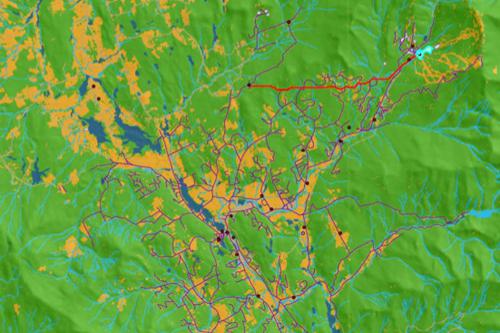
3. Identify the factors that influenced the location of ferrous metallurgy enterprises on the map (at the teacher's choice). Including the Vologda region.
When placing metallurgical plant in Cherepovets they took into account:
1) position on freight traffic iron ore(from Karelia and Murmansk region) and coking coal (from the Pechora basin)
2) proximity of the consumer - metal-intensive production facilities in St. Petersburg, Moscow, cities - centers of the automotive industry on the Volga
3) convenient transport position: Railway, highway, Volga-Baltic waterway
4) availability of a water source - Rybinsk reservoir
5) skills of the population: the production of cast iron from swamp iron ore (Ustyuzhna Zhelezopolskaya - residents of Ustyuzhna mined swamp ore and smelted cast iron from it)