In a rational complex of geological exploration for oil and gas, the exploration stage, as can be seen from the table of the rational sequence of these works, is a natural continuation of the exploration. Exploration works are aimed at industrial evaluation of deposits and fields discovered at the prospecting stage and their preparation for development. In this case, the hydrocarbon reserves of the industrial category C1 obtained as a result of exploratory drilling and the preliminary estimated reserves of the category C2 must be converted into commercial ones over the entire area of the discovered field or deposit.
The main types of exploration work are: drilling and testing of exploration wells, analysis of all the necessary geological and geochemical information to clarify the parameters of a deposit (field) and prepare it for trial operation. If necessary, borehole seismic exploration by the CDP method and, in a small amount, field geophysical methods can be envisaged.
The main methodological principle of intelligence, formulated by G.A. Gabrielyants and V.I. Back in 1974, the principle of uniformity of drilling, which is implemented by the uniform placement of exploration wells over the volume of the reservoir, is a poroskunom. According to this principle, a detailed study is provided, first of all, of those parts of the deposit (fields) that contain the main reserves of hydrocarbons. At the same time, the accuracy of reserves estimation increases, and, consequently, the quality of field preparation for trial operation and subsequent development. At the same time, a differentiated placement of exploration drilling is envisaged, taking into account the morphogenetic features of the structure of a deposit or field.
Modern exploration of oil and gas fields takes into account the principles of optimization and universality of the exploration drilling process, first proposed by V.M. Crater and V.I. Biryukov (1976). These principles are formulated as follows:
- The principle of a rational system and completeness of studies of an individual deposit or field.
- The principle of successive approximations in the study of a field or a separate deposit.
- The principle of relative uniformity of the study of the object of exploration.
- The principle of the least labor, applied scientific and material and technical costs.
- The principle of the least investment of time and achievement of the greatest savings while observing energy-saving technologies.
A rational system for the exploration of oil and gas fields involves the drilling of a certain, usually minimal, number of exploration wells, which are laid in a certain sequence to obtain information necessary and sufficient for the industrial assessment of an open field and its preparation for development. At the same time, the system for placing exploration wells should correspond to the specifics geological structure the object under study.
The section of an open deposit (field) is divided into exploration levels. The exploration stage is understood as a part of the sedimentary cover section, which includes one or more productive strata located at close hypsometric levels and characterized by similarities in the geological structure of the host rocks and the physical properties of hydrocarbon fluids. Their exploration can be carried out with a single grid of wells.
There are three systems and the corresponding methods of exploration drilling: triangular, annular and profile with a system of parallel transverse and longitudinal profiles of exploration wells.
Triangular exploration drilling placement system. This technique is the oldest and was used at the dawn of development. oil industry... In this case, as can be seen from Fig. 65, the first exploration well is located in the most optimal structural and hypsometric conditions, the rest are laid as exploration in the form of equilateral triangles with a side whose length should not exceed 500 meters at angles of inclination of the local uplift wings up to 10 degrees. At 20 degrees of inclination, it decreases to 400 meters, then shrinking by about 50 meters with an increase in the angle of inclination of the wings by every 5-6 degrees.
The irrationality of the adopted triangular system for the placement of exploration wells, even with the assumed maximum distances between them of 500 meters, consists in drilling to comply with the specified principle of uniformity of an unnecessarily large number of them. This leads to a significant increase in the cost of drilling. The process is justified to a certain extent with the achievement of a very modest geological efficiency (up to 80-100 conventional tons per 1 meter of prospecting and exploration drilling) only when the area of the trap and the predicted deposit is no more than 2-2.5 km2. The exploration experience of identified lithological and stratigraphic hydrocarbon accumulations up to 1-1.5 km2 in size also testifies to the profitability of implementing a triangular exploration drilling system.
In the USA, along with large bay-like lithological-stratigraphic deposits, small lithologically limited, or "lace", or lenticular, accumulations of oil and gas with recoverable reserves of up to 1.5 mln. Conv. t up to 1.5-2 km2. For the exploration of such fields, a triangular grid of wells is also used with the number of them from 12 to 15, which is within the profitability range with an average efficiency of up to 120 conventional. t / m. In Russia, such a system for placing exploration drilling was successfully used as a rational one in 1912 at the initial stage of exploration discovered for the first time in world practice by I.M. Gubkin "sleeve-like" oil deposits with the transition from 1916 to profile drilling. Currently, this exploration technique is used in the exploration of small oil deposits associated with erosional "incisions" of the pre-Visian and pre-Turnean age within the Volga-Ural and neighboring oil and gas regions.
Annular system for placement of exploration drilling. The rational nature of the ring system of exploration of discovered deposits and fields, successfully combined with the development of individual explored floors, is confirmed by the example of the unique Zapolyarnoye gas condensate field total area of over 2000 km2 and the value of recoverable gas reserves of 1.5 trillion. m3. In general, searches were carried out according to the "exploratory drilling cross" system with 12 exploratory wells, and exploration - 27 exploratory wells placed according to the annular technique shown in Fig. 66.

The specificity of the annular system is determined at the Zapolyarnoye field by the following position of the wells in the structural inter-iso-gypsum fields. Within the first field of the discoverer from well 1, 4 drilling rigs are laid. After delineating the internal area of the field in the next more external field in relation to the already delineated central zone, 5 drilling rigs are designed, marked with squares. Having completed the delineation of this part of the deposit, it is planned to develop the outer zone of the gas condensate field with the placement of first 7 exploration wells in the penultimate field, and then 9 - in the last inter-iso-gypsum contour framing the field.
The rational nature of the annular exploration drilling system in the development of the unique Zapolyarnoye gas condensate field is confirmed by the achieved value of geological efficiency, exceeding 1000 conv. t per 1 m of prospecting and exploration drilling.
Consequently, the high efficiency of using the ring system is achieved by the presence of large (up to gigantic and more) hydrocarbon reserves and a relatively simple structure of the field with a reservoir of a stratal or massive structure of a vaulted type. This should, first of all, be guided by when choosing a rational method of exploration, which, as can be seen from the example of the unique Zapolyarnoye field, is fully justified by the results obtained. The ring system was used in the exploration of a number of large gas condensate fields in the Yeisk-Berezanskaya gas-bearing region, in particular Kanevskoye and Leningradskoye. In the United States, this technique was used to explore the main arbokle limestone reservoir in the largest oil field in Oklahoma City in the Western Inland Province.
Profile system for placement of exploration wells
In modern
conditions for the exploration of oil and gas deposits and deposits of anticlinal and non-anticlinal types of any structure complexity, except for the cases noted above in the first methods, the most effective and universally rational is the profile system of exploration drilling. Its essence lies in the design of a certain number of exploration wells, each laid at the points of intersection of the transverse and longitudinal profiles. Moreover, depending on the size of the explored field, the distance between the transverse and longitudinal profiles and the area per one well projected by drilling are strictly regulated. Compared to the previous methods, the profile method is the most “flexible”, allowing for current changes in the rational well pattern and, thereby, the coverage area of the explored part of the field.
Let's consider typical examples of placement of exploration wells according to the profile system. In fig. 67 shows the location of wells in the gas condensate field. A larger eastern block was brought into exploration according to the profile method, and the rational area for each well reaches 26 km2. The position of the wells on the profile is shown using the example of the central part of the exploration block. The total number of wells for the eastern block of the field is 38. With the same selected parameters, the rational number of exploration wells for a smaller western gas-condensate reservoir with the same GWC mark will be 26. However, taking into account the gas-condensate type of hydrocarbon fluid and the possibility of one and a half increase in the distances between the profiles and the area per well, the total number of wells in the eastern block without violating the principle of rationality can be 25, and for the western reservoir - 18.

In fig. 68 shows a rational technique for the anticlinal block
dimensions of 30x70 km, complicated by faults and including an oil reservoir
with a mark VNK minus 1590 m.
wells along a system of parallel mutually perpendicular profiles
with an area of each square 18 km2.
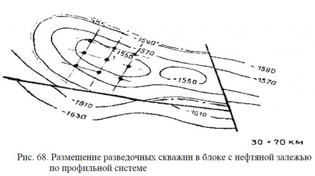
The position of the profiles and wells is shown on the example of the central part of the western dome of the anticline.
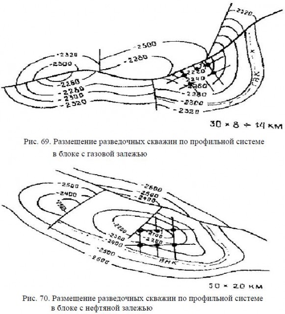
On the example of the central part of the reservoir, a rational placement of exploration wells for the western larger block of the anticlinal trap with the predicted oil reservoir at the OWC mark minus 3200 meters is given. As the most rational, a technique similar to the one noted above was adopted, with an area of individual squares of a grid of wells of 10 km2 and a number of wells 12, starting with the exploratory well-discoverer of the field. For the exploration shown in fig. 69 and 70, respectively, predicted gas condensate and oil fields a rational well placement system is considered for productive blocks.
From prospecting well 1, which gave industrial flows of gas condensate and oil, it is planned to develop a rational grid of projected drilling rigs while maintaining the “quadratic” principle of placement. For the explored gas condensate field, the area per one well, taking into account the gas-condensate type of HC fluid, is 12 km2 instead of 8 km2 for oil, and the rational exploration complex includes 24 wells.
Exploration development of other blocks of the field should not provide for an increase in the number of drilling rigs. As rational for a larger predicted oil reservoir (Fig. 70) with an OWC mark of minus 2400 m, it is also envisaged in the central part of the structure from prospecting well 1 according to the scheme shown in the figures above; the area of 28 km2 per drilling was taken as a more efficient one, and the total number of exploration wells was 32. Further, according to the same scheme, exploration by 16 wells of a smaller, central structural block is carried out.
In fig. 71 shows a vaulted gas condensate reservoir with a GVK mark of minus 1050 m, complicated in the central part by a horst bounded by the surfaces of displacers in the form of two rays.
The most rational for the exploration of this field will be sequential drilling according to the profile-square pattern, first of the central part of the deposit with an area of 8 km2 per well, starting with a horst. Outside the horst, the distance between the wells can be increased up to 3 km, and the area per drilling rig - up to 10 km2. The rational number of wells for exploration of the field should not exceed 20. For the western smaller block - 12 wells.

For exploration of a vaulted oil reservoir in an anticlinal trap, complicated from the south by a fault (Fig. 72), with an OWC mark minus 2810 meters with an area of 18x6 km, the same square rational well pattern with an area of 5 km2 is used. Exploration well 1 is the starting point for the start of exploration. The minimum number of wells for full coverage of the reservoir with the transfer of resources to the C1 category will be 20.

Exploration of domed oil deposits, shown in Fig. 73 and 74, is carried out according to a similar profile system with an area of 4 km2 per exploration well. The total area of the field, as well as the morphostructural conditions as a whole, are identical to the deposits (Fig. 70 and 71), using also as a basis for placing a rational drilling scheme in the central part of the deposit with exploration well 1.

In fig. 75 shows a gas condensate reservoir of a complex structure of a domed tectonically-screened type with an elevation of the GVK minus 775 meters. Rational placement of exploration drilling provides for the placement of exploration wells in the central block from well 1 along a grid of 8 km2 (up to the GWC) of ten wells, which makes it possible to count on the most effective exploration of the field with an indicator of at least 500 conv. t per meter of exploration drilling.
An example of a rational exploration of a near-contact oil reservoir confined to the diapir brachyanticline is shown in Fig. 76.

Within the reservoir, a rational drilling grid is designed according to the specified profile scheme with the area per well of 6 km2. The project provides, as can be seen from the figure, the drilling of 30 exploratory wells up to the OWC at minus 3300 m, starting from exploratory well 1 - the discoverer of the field.

For the deposits of the structural-lithological and structural-stratigraphic types discussed above, the same profile system for the placement of exploration wells with the indicated square grid remains rational. At the same time, the area per well varies from 5 km2 for medium-sized deposits to 18 km2 for large ones.
I would be grateful if you share this article on social networks:
Site search.
Oil production is a complex and multi-stage process. An integrated approach is required, including several stages of study, requiring huge investments and labor costs. Striving to maximize efficiency, reduce costs and eliminate negative consequences for environment pushes companies to innovate and thoroughly research the field long before work begins on it.
Intelligence service
Geological exploration and production at all times required huge investments, the use of the most modern technologies, deep and comprehensive expertise, and despite all this, the risks are enormous.
Drilling the simplest shallow well costs millions of rubles, on the shelf, for example, in the North Sea, costs can reach 1.5 billion, and this is not the limit.
Against this background, the importance of all stages of geological exploration can hardly be overestimated, because every well that misses oil can cause huge losses. In order for the money invested in the project to pay off, it is necessary to make sure in advance that there are enough raw materials in the bowels, and it will be possible to extract it.
And for the long-term development of the company and the industry as a whole, it is necessary to constantly look for new oil deposits. Even small interruptions are fraught with a sharp decline in production in the future.
In those days, when hydrocarbons were practically not used in industry, and only their flammability and viscosity were valued, no one chased after millions of barrels. Therefore, raw materials were often mined in the same place where they saw it on the surface of the soil, and no one could predict when it would end.
In 1962. in the American comedy show Beverly Hillbillies there was such an episode: the main character with a gun hunts a rabbit, shoots, misses and hits the ground, and oil immediately flows out of there. Another minute and an ordinary American becomes a billionaire.
As the industry developed at the beginning of the twentieth century, large volumes of raw materials were required, and it is this time that can be considered the starting point for geological exploration in the modern sense. In order to drill where there is enough oil, it was necessary to find out several things: what the structure of the soil layers looks like, and in which layer the raw materials lie, how to visually assess the potential attractiveness of the site, how to check the presence of oil and gas, and then estimate the volume.
How does oil occur?
One of the key properties of oil is that it is less dense than water. It is very easy to check this: pour sunflower oil into any container and add water. The water will be at the bottom, the oil will rise to the top. If air, which is a mixture of gases, remains in the container, then it will be located at the very top, forming a third layer. This is how oil-bearing strata are formed: water below, oil in the middle, natural gas above.
Rocks containing oil and allowing free movement and accumulation of liquids and gases are called reservoirs. Most often they are sedimentary. The porosity of reservoirs depends on the types of grains, as well as on the presence of cement. Permeability is determined by the size of the pores and their connectivity.
The main reservoirs of oil are sands, sandstones, conglomerates, dolomites, limestones and other well-permeable rocks.
In this case, for the formation of the reservoir, it is necessary that the porous layer was enclosed between impermeable layers, for example, clay and gypsum.
Oil lies in the so-called "traps". Drilling at random is useless. To increase the chances of success, oilmen use aerial photography and seismic surveys.
A trap in which hydrocarbon-rich layers are sandwiched between impermeable layers is the main prey for oil workers. But drilling at random is useless, because most of the fields are located at a depth of more than a kilometer and the trap is not visible from the surface.
Aerial photography and seismic exploration
To increase the chances of success, mankind first learned to analyze the terrain, determining indirectly where the oil is located. This direction was developed after the advent of aerial photography. Nowadays, the emphasis is on aeromagnetic and gravimetric surveys - with the help of such methods, it is possible to reveal the structural features of the soil.
Moreover, today space technologies are also helping oilmen: a constellation of Russian scientific satellites helps to determine how the soil was formed and where the raw materials could be deposited. Expeditions also play an important role, the purpose of which is to find out whether it is advisable to start drilling.
Today, onshore seismic surveys are carried out using special mobile platforms and a network of thousands of high-precision sensors. Computers, based on the data obtained, draw up a map on which not only the outlines, but also information about the composition of certain layers are clearly visible. The fact is that rocks of different types reflect sound in different ways, that is, salt "sings" differently than, for example, clay.
Sound waves can penetrate the earth for 3 km. in depth and more. The soil is really good at conducting sound, and it was not for nothing that our ancestors put their ears to the ground to hear the stomp of horse hooves at a distance of several miles. Based on the results of such safe “tapping” and “tapping”, the final decision on drilling a test well is made.
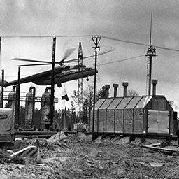
A documentary film “Attention! Explosion!" (Kuibyshev newsreel studio, 1975)
The specificity of offshore operations is that pneumatics have to be used here. First, a network of sensors is lowered to the bottom, and then the ship, using special sound cannons that release compressed air, sends sound signals that allow you to find out what is under the seabed. These technologies are used only in conjunction with a whole range of measures to prevent the impact on the marine fauna.
In general, it is surprising how different areas of knowledge are connected in our world. This is how Andy Hildebrand, the author of modern computer analysis of seismic data, revolutionized the music industry with the creation of a vocal note correction system ("Autotune").
 |
Even before the revolution, on the initiative of V.I. Vernadsky and A.P. Karpinsky, a commission for geological exploration was created. After the revolution, the activity was resumed. The Geolkom was tasked with providing scientific support for geological prospecting and exploration work, developing relevant areas of science, and training specialists. |
 |
|
 |
By this time, most of the territory of the USSR was explored by geologists from the air. Maps have been compiled on a scale of 1: 5,000,000 and 1: 2,500,000, and individual ore areas by geological maps of scales 1: 200,000 and larger. During this period, new deposits of copper-nickel, iron, apatite ores and rare metals were discovered. |
 |
1941-1945 During the war years, the country's geological service was given the urgent task of expanding and using the mineral resources of the Urals, Siberia, the Far East and Central Asia to provide the front with strategic types of mineral raw materials. Many deposits discovered in the pre-war years were brought into production. |
 |
A qualitative transformation of the country's geological service has taken place. Geological exploration was transferred to the USSR Ministry of Geology and Subsoil Protection. Among the most significant achievements are the discovery of diamond deposits in Yakutia, oil and gas in Tyumen and the Caspian region, nickel, copper and precious metals in Norilsk, on the Kola Peninsula, Kursk magnetic anomaly, etc. |
 |
Reorganization again. As a result, more than 200 territorial and specialized subdivisions operated in the system of the USSR Ministry of Geology, uniting 700 stationary expeditions and several thousand geological parties. Cadres of graduates were trained in 50 universities of the country and numerous technical schools. |
 |
According to the formed in 1981. in the Mingeo of the USSR there were 90 associations, including 3 all-Union ones. In the mid-1980s, the number of workers in the geological industry reached 700 thousand people, of which more than 100 thousand are specialists with higher education. The scientific sector was represented by specialized research institutes and design bureaus, in which more than 400 doctors and over 4000 candidates of sciences worked. |
Trial towers
Once a decision has been made on how deep and where the oil trap is located, it is time for the test wells. In fact, if we are talking about strategic exploration, then key, parametric and structural wells can be drilled at an early stage to determine which fields the company can count on in the future.
If we talk about the launch of commercial use of a particular field, then it is important to understand what category of raw materials and in what volume are underground, how easy it is to extract, and in general, from the point of view of monetization, is it worth starting full-scale production here?
Interestingly, the first target when drilling prospecting wells is not the oil itself, but a column of rock, the so-called core. A sample of one or another cylindrical layer is raised to the surface, which is then sent for detailed analysis to the laboratory. Having made conclusions about the prospects for oil production based on the core structure, the sample is sent to a special core storage, where it will always remain, even when the field itself is depleted.
In addition to physical samples, you need to get and Additional information... For example, how the soil layer changes with distance from the well. A special geophysical probe can be lowered into the ground. I must say that the oilmen are not devoid of humor. This method is called logging from the French "carotte" (carrot). A very high-tech probe looks like a carrot.
Indirect research methods, from space and aerial surveys to seismic analysis, play a huge role in geological exploration. All these technologies have made it possible to simultaneously reduce costs for companies, speed up the decision-making process for drilling and reduce the negative impact on the environment. It is important that the accuracy of determining the locations of oil deposits has increased. Initially, up to three quarters of the preliminary wells had to be permanently sealed: no oil was found underground. Today, Rosneft makes the right decisions in its research 70-80% thanks to the use of modern technologies and comprehensive expertise.
Rosneft is actively conducting geological exploration work in such promising regions as Eastern Siberia, arctic shelf, Far East and shelf southern seas Russia. Without these works, there would be no development of the Vankor field, the Sakhalin-3 and Sakhalin-5 projects. It should be noted that offshore exploration is one of the most important strategic directions, since, despite significant capital investments, it is it that will increase the total volume of reserves and provide business growth prospects for years to come.
In 2014, Rosneft held the lead among Russian companies in the field of geological exploration.
In 2014, there was an increase in the main types of geological exploration: the volume of 2D seismic exploration (flat maps) increased by 3%, to more than 2 thousand linear meters. km. 3D seismic exploration (volumetric maps) exceeded 9 thousand square meters. km. Growth in comparison with 2013 is about 9%. Exploration drilling has drilled 223 thousand meters of rocks, which is 4 thousand meters more than in the previous year. Exploration drilling efficiency increased to 80% from 76% in 2013.
- Exploration costs amounted to 42.9 billion rubles, while in 2014 the specific indicator of the cost of 1 tonne of oil equivalent increased. decreased by 7%, to 112 rubles.
- Increase in reserves in Western Siberia - 186.5 million tons of oil and 72.2 billion cubic meters. m of gas. 57 exploration wells with 89% success rate. The Tavricheskoye field was discovered as part of the Uvat project in the south of the Tyumen region and 18 new deposits.
- The total increase in reserves in Eastern Siberia is about 49 million tons of oil and 43.6 billion cubic meters. m of gas. 9 new deposits were discovered.
- The total increase in reserves in the Volga-Ural region is 42.5 million tons of oil and 4.0 billion cubic meters. m of gas. The Rudnikovskoye and Yuzhno-Barsukovskoye fields in the Samara region and 37 new deposits were discovered.
- At the end of 2014, the residual recoverable reserves (IFRS) of Rosneft under the ABC1 + C2 category amount to 11.5 billion tons of oil and condensate and 7.2 trillion cubic meters of gas. m of gas.
- The replacement of commercial categories of ABC1 hydrocarbon reserves, taking into account acquisitions, is 461 million toe, or 156% as compared to 2013. At the same time, the multiplicity of reserves in relation to current production is 45 years.
Building up the resource base is one of the key priorities of the Company. In 2014, as a result of successful exploration work, 64 new deposits and 5 fields were discovered, including 2 offshore fields. The total reserves of discoveries are about 560 million tonnes of oil equivalent.
In 2014, the increase in reserves in the ABC1 category due to geological exploration amounted to 252 million tonnes of oil and condensate, and 132 billion cubic meters of gas. m.
Rosneft's proven hydrocarbon reserves in accordance with SEC (US Securities and Exchange Commission) standards amounted to about 34 billion barrels. AD (about 4.6 billion toe). Including reserves of liquid hydrocarbons (oil, condensate, NGL) amounted to about 25.4 billion barrels. AD (3.4 billion toe), gas reserves - about 50 trillion cubic meters. feet (over 1.4 trillion cubic meters). Thus, in 2014, the SEC hydrocarbon reserves replacement ratio was 154%; the replacement rate of oil, gas condensate and NGL reserves reached 116%, the replacement rate of gas - 263%. The increase in hydrocarbon reserves amounted to 963 million barrels. AD (134 million toe).
According to the prms classification, the resource endowment is 20 years old for oil reserves and 39 years for gas reserves.
Rosneft exploration
- Proved hydrocarbon reserves: 33,977 million barrels. AD
- Hydrocarbon reserves replacement ratio: 154%.
- Increase in hydrocarbon reserves: 963 million barrels. AD
Oil production
Mankind truly discovered the potential of oil and gas only in the 20th century. Hydrocarbons laid the foundation for the most important technologies and gave impetus to the development of industry and energy. At the same time, it is precisely the role of oil in the world economy that remains key. This opinion is shared not only by the oilmen themselves, but also by other representatives of the fuel and energy sector, as well as by relevant departments.
All figures are on the surface: more than half of all generated energy comes from oil. In addition, 90% of all chemical products is created on its basis.
In 2014, more than 84 million barrels of "black gold" were produced in the world every day. In the list largest manufacturers oil from the OPEC countries, the USA, Russia and the PRC.
However, full-scale production began relatively recently, because it is not so easy to pump out liquid raw materials from the bowels of the earth. In the previous chapter, we talked about where the oil is located, and how to find it. They also touched upon the topic of appraisal and preliminary drilling. But when did humanity begin to extract oil, and what technologies are used today?
Oil production history
 |
6 millennium BC Humanity has learned to extract oil The first method of oil extraction was collection from the surface of reservoirs - it was used in Media, Babylonia and Syria even before our era (according to some sources, 6-4 millennium BC). In Egypt, oil was used for embalming. They drew from a well - with a bucket. By the way, in English language the term “Well” is still used to refer to wells. |
 |
4th century In ancient China, oil was extracted using bamboo pipes The Chinese have learned to extract raw materials from the ground using bamboo drills. Already in the fourth century AD, they were able to pump oil from wells up to 240 meters deep! In ancient times, there was no need to produce oil in large volumes, because it was used primarily as a combustible material, including in military affairs. |
 |
|
 |
18 century Ukhta becomes the center of oil production in Russia This river, on which they later built whole city, in the 18th century it became the first center of oil production. Here I must say thanks to Peter the Great, who founded the Berg Collegium - the first department responsible for mining. In total, up to 1767, 3.6 tons of oil were produced in Russia, but still in the same "well" way. |
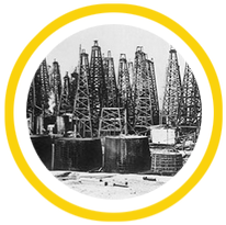 |
19th century Commercial oil production begins using wells In the 19th century, they learned to manipulate pressure to lift raw materials to the surface. The first real well was drilled in 1846 in the village of Bibi-Heybat, which was then part of Russian empire... The field is located near the city of Baku, which Marco Polo glorified as the center of world oil production. But this drilling was exploratory. Real mining began in 1864. in the Kuban, in the village of Kiev. The Americans were the first to decide to extract oil on the shelf: in 1896. the tower was set up off the coast of California. |
Oil production in the USSR and the Russian Federation
The Soviet Union was fully self-sufficient in oil and became one of the main exporters of raw materials. In 1940. on the eve of the Great Patriotic War, more than 30 million tons of oil were produced, and although the centers of oil production became one of the main targets of the enemy during the war, it was not possible to deprive the Soviet army of fuel. And the USSR began the development of new oil fields in addition to the oil-bearing regions of Baku and the construction of new refineries.
Thanks to the development of new deposits, primarily in Western Siberia, The USSR rapidly increased production volumes. So in the period from 1971 to 1975, it grew from 7.6 million barrels per day to 9.9 million barrels per day. To this day, the region remains one of the main “oil trump cards” of Russia: about 60% of the annual oil production in our country is produced in the Khanty-Mansiysk Autonomous Okrug. In 1988, the Soviet Union reached a record of 11.4 million barrels per day, with most of it coming from fields in Western Siberia. But from that moment on, technological omissions made themselves felt - it was impossible to contain the decline in volumes for a long time.
The collapse of the industry had a great impact on the crisis Soviet Union... Domestic demand fell, and export opportunities were lacking. Due to financial difficulties, drilling was reduced, wells were not properly maintained, and no repairs were carried out. The decline in oil production stopped only in 1997.
In 2014, Russia produced an average of 10.578 million barrels of oil daily. This is a record figure for the entire post-Soviet period.
In the future, the level of production may continue to grow due to the development of new fields, for example, on the Arctic shelf.
 |
1934
|
Well drilling
Since the first wells were drilled in the 19th century, a lot of oil has flowed under the bridge ... Oil workers have learned to pump out raw materials even after the well stops flowing. Otherwise, 80-85% of the oil could not be brought to the surface, and the depth of the wells can reach several kilometers. How are modern oil rigs arranged and what methods are used to maximize oil production?
For drilling wells, drilling rigs are used, which in the common people are called rigs. In fact, the tower is only part of the complex of structures involved in the process.
The diameter of oil and gas wells decreases from the beginning of the "wellhead" to the end - "bottomhole". The diameter does not exceed 900 mm at the wellhead and is almost never less than 165 mm at the bottom. The depth can range from several tens to several thousand meters. After drilling, the well is reinforced with special pipes and cement. During drilling, the well is flushed, excess rock residues are pumped out to the surface.
There are two main types of drilling - rotary and downhole drilling.

The main difference is that rotary drilling provides for the location of the motor on the surface, while in the downhole motor it is located above the bit, "biting" into the rock.
In various situations, vertical drilling is used, directional, including horizontal, cluster (a network of deviated wells, the heads of which are grouped), multilateral (a well forks), and offshore drilling is distinguished separately, which will be discussed in a special chapter.
Modern mining methods
At the moment, three methods of oil production are relevant, depending on the pressure in the oil-bearing reservoir and the methods for maintaining it.
Primary method implies the release of oil to the surface under the influence of natural forces. This is the same oil fountain that is often shown in films. After the opening of the reservoirs holding the raw materials, the oil is replaced by groundwater, the gas is pushed out due to the expansion of gases and other processes that change the pressure in a natural way. As we have already mentioned, only a small amount of raw materials can be obtained by the primary method.
Additional tools are used to increase efficiency. Are applied different types pumps, including submersible, sucker-rod and electric. Sucker rod pumps are used in combination with mechanical drives located on the ground. We know them well: these are pumping units. About 2/3 of all production wells in the world use sucker rod pumps, which is why the "rocker" has become a symbol of the oil industry. Surface-drive sucker rod pumps can be used for shallow vertical wells and deviated wells with slight deviation from the vertical. Typical depths are from 30 meters to 3.3 km, maximum depths are 5 km.
Secondary method Oil extraction is used when the raw material cannot be raised to the surface by natural forces or by means of pumps. Any field at some point requires such an approach. Then you have to build up the pressure, or reduce the density of the oil, pumping gas or water into the field. Airlift technology lifts oil from the well along with air bubbles. It is specially pumped into the pipe, and since air is even less dense than oil, its bubbles help the raw material to escape. Gas lift involves the use of other gases, such as carbon dioxide. The use of water is possible. This option implies additional costs, since oil mixes with water, and as a result, they have to be separated. This phenomenon is called the "water cut" of oil. Combination of primary and secondary methods provides recovery from the well 35-45% of raw materials.
Tertiary method- territory of high technologies. The viscosity of the oil is reduced by heating. The most common tool is hot water vapor. The easiest way is to use cogeneration, in other words, capacities that allow you to combine the production of electricity and heat. The well-known CHP plants work according to this principle. Instead of steam, you can try burning part of the oil directly in the formation. And then there are detergents - substances that can change surface tension and release oil that refuses to break through water. As a result of using the tertiary method, more 5% - 15% of raw materials buried underground.
Production figures, coupled with the results of exploration work, form the basis of statistics that allows investors to understand how prepared a particular company is for the challenges of today and tomorrow.
Now let's take a closer look at the results of oil production.
At the end of 2014 Rosneft was the largest public company in the world in terms of production. The total production volume reached 251.6 Mtoe. This brings the organic growth to 4.8%. And taking into account new assets from the date of acquisition, the growth reached 14.5%. The record is also in terms of production efficiency. Rosneft has the best production cost indicator. The specific indicator of operating costs is $ 3.9 per barrel of oil equivalent.
The lion's share of Rosneft's production business is provided by oil assets. The production of oil and other liquid hydrocarbons provided 204.9 million toe. Daily production of oil and liquid hydrocarbons remained at the level of 4.2 million barrels per day.
It is important that at such promising fields as Vankorskoye, Verkhnechonskoye, as well as within the Uvat project, a production record was set since the beginning of development - 22 million tons. However, the company continued to effectively develop those deposits that were developed a long time ago. It is interesting to draw attention to the company's successful work to slow down the natural rate of decline in production at the fields of OJSC Varieganneftegaz and OJSC Samotlorneftegaz. In particular, this was achieved through effective waterflooding management and drilling of wells with multistage hydraulic fracturing.
We also note that gas production increased by 48.6% to more than 56.7 billion cubic meters. meters taking into account new assets from the date of acquisition.
Shelf
Offshore drilling and production is one of the most promising areas in the oil industry. Offshore fields are capable of providing companies with a rich resource base. It is difficult to overestimate their importance in the long term. And while traditional onshore projects often pay off more quickly, oilmen know that they need to invest in a shelf that will bring profit in the future. Working at sea requires not only money, but also comprehensive expertise.
Perhaps it is the technological aspect of offshore production that is most interesting, and we will turn to it more than once in this chapter.
The shelf is the underwater margin of the continent, adjacent to the land and similar to it in geological structure. This is a kind of "shelf" within which the sea is not so deep - usually about 100-200 meters.
The name “shelf” is borrowed from English, but it is interesting that the word “shelf” is rarely used by English-speaking oilmen when it comes to drilling, preferring the term “offshore drilling / production” (“offshore drilling and production”). The fact is that the concept includes not only platforms on the continental shelf, but also those that are installed on lakes and other bodies of water that are not related to the shelf, as well as in deep water, that is, outside the shelf.
However, it is the “shelf” that encircles the continents that stores huge reserves of hydrocarbons. Thus, the initial total hydrocarbon resources of the Russian shelf amount to about 100 billion tons of standard fuel.
The total area of the world's shelves is about 32 million km². The shelf at the northern edge of Eurasia is the most extensive. Its width reaches 1.5 thousand kilometers. Other wide areas are in the Bering Sea, Hudson Bay, South China Sea, off the northern coast of Australia.
The idea to extract oil on the shelf appeared at the end of the 19th century. Of course, we thought about this before, but there was neither a sufficient technological level, nor a special need to pump raw materials from under the water, because hydrocarbon fuel was not used very actively.
History of offshore production
In 1891 the Americans were able to test a new method of production by drilling wells in the man-made Lake St. Mary's in Ohio. Interestingly, the investors were small companies hoping to make money from the oil boom.
In 1896 the real Santa Barbara began: wells were drilled in the Summerland field, located in the Santa Barbara Strait off the coast of California. But so far, like the famous TV series, American offshore drilling was not very believable: the drilling rigs were located on special piers that started on the shore and went out to sea.
Early 20th century offshore drilling was in full swing. In Canada, they developed a deposit on Lake Erie, in the USA they reached Lake Caddo, located in the states of Louisiana and Texas, that is, very close to the famous Gulf of Mexico.
Almost immediately after the successful implementation of these projects, the Americans began to develop the Gulf of Mexico, and in Venezuela they mastered Lake Maracaibo.
The Russian Empire, and then the USSR, were at the forefront in the field of oil production. The Bibi-Heybat settlement near Baku has twice become a record holder. In 1846 here they drilled the first real oil well, and in 1923 they poured an island in the Caspian Sea to extract oil.
In 1937 PureOil and SuperiorOil, now known as Chevron and ExxonMobil (SuperiorOil became part of it), built a platform capable of producing oil 1.6 kilometers off the coast of Louisiana, but the ocean was only 4.3 meters deep.
In 1946 Magnolia Petroleum, which later became part of ExxonMobil, delivered the platform 29 kilometers off the coast of Louisiana, with a water depth of 5.5 meters.
However, Kerr-McGeeOilIndustries (now AnadarkoPetroleum), which acted as operator for the PhillipsPetroleum (ConocoPhillips) project and StanolindOil & Gas (now part of BP), demonstrated the first oil produced offshore from the line of sight from the shore.
In 1949 a platform was built called "Oil Rocks" (also called the village and the field). It was erected on metal overpasses in the Caspian Sea, about 40 km east of Absheron Peninsula on the territory of Azerbaijan.
In the middle of the 20th century it became necessary to carry out production further from the coast. As the depth of the ocean grew, new technologies were developed. This is how jack-up rigs appeared, the first of which belonged to the future US President George W. Bush (Sr.).
In 1961 the first semi-submersible oil platform appeared. The story of its creation is quite curious: BlueWater built a conventional platform for Shell, but then the partners decided to try to use it in a "floating" mode, and it turned out that it was quite profitable. Until now, in the open sea at great depths, oil has been extracted from such platforms. Sometimes anchors are used to hold them in one place, sometimes, as in the case of the infamous Deepwater Horizon, special engines.
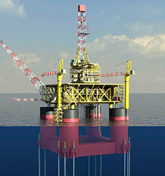
Oil platforms
Oil platforms can be classified into several types. New options were developed as the technological development of the industry, and as a result, today there are platforms for almost all types of fields - from those located in shallow water to the deepest.
 |
It is installed on metal or reinforced concrete supports and thus provides high stability. However, it cannot be moved, so it makes sense to build such a platform only against the background of the presence of vast reserves in a particular field. |
 |
A kind of stationary platform called CompliantTower: truss-supported platform with guy wires. It can be installed in deep water, but such a design does not tolerate strong currents and wave shocks. |
 |
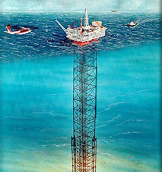
It floats on the surface of the water on several columns, but is attached to the bottom with powerful cables. Suitable for mining at depths of 300-1.5 thousand meters. |
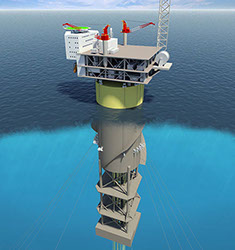 |
It is also held by ropes, but is able to remain on the surface and in an upright state without them thanks to a powerful underwater counterweight. It can also move from side to side, changing the tension of the cables held by the anchors. |
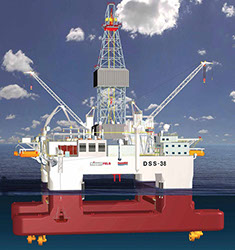 |
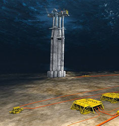
Excellent for offshore drilling. It is used at a sea depth of up to 3 thousand meters, and the depth of a well can reach 10 thousand meters. Placed above the drilling site on pontoons. Anchors or special motors hold it in place. |
Offshore work in our country began in the 19th century. We have already talked about the Caspian Sea, which for a long time remained a key point in world oil production. However, shelf projects were not key for the USSR. Apart from the Caspian Sea and Sakhalin, there were essentially no investment targets. Only in recent decades has Russia begun to actively develop the shelf.
It is expected that in Russia the share of hydrocarbon production on the continental shelf by 2020 will amount to 4% of the total volume. First of all, production growth will be provided by Sakhalin and the Arctic. Prirazlomnoye and Shtokman are located here, as well as the Yuzhno-Karskaya oil and gas region, where Rosneft is already actively drilling.
Offshore projects are a strategic area of activity for Rosneft.
The company is a leader in the development of the Russian shelf and has 51 license areas with a total volume of hydrocarbon resources in excess of 45 billion tonnes of oil equivalent, in the Arctic, on Far East, in the Black, Caspian and Azov seas in the south of Russia. Rosneft has entered into strategic partnership agreements with major international companies with advanced experience in offshore projects.
Arctic shelf
In 2014, the world's northernmost well was drilled in the Kara Sea at the Universitetskaya-1 structure.
The area of the Universitetskaya structure is 1200 square kilometers with a "trap" height of 550 m. The resources of this structure are more than 1.3 billion tons of oil equivalent. In total, about 30 structures have been discovered in the three East Prinovozemelskaya areas of the Kara Sea, and the expert assessment of the resource base of the 3 areas is 87 billion barrels or 13 billion tons of oil equivalent.
The Kara offshore oil province, according to experts, will surpass such oil and gas provinces as the Gulf of Mexico, the Brazilian shelf, the Arctic shelf of Alaska and Canada in terms of resources, and is comparable to the entire current resource base of Saudi Arabia.
The sea depth at the drilling point is 81 m, the design depth of the vertical well is 2350 m from the rotor table. To implement the project, such sections of the project documentation as an assessment of the impact of a well on the environment, an oil spill response plan, etc. were developed and approved by the regulatory authorities.
Before the start of work, public consultations, a state ecological expertise and a main state expertise were carried out.
Rosneft and ExxonMobil
In the summer of 2014. Rosneft and ExxonMobil, as part of the Karmorneftegaz joint venture, have drilled the northernmost well in Russian Federation Universitetskaya-1 using the West Alpha platform.
The West Alpha platform was supplied by the Norwegian company North Atlantic Drilling, with which Rosneft entered into long-term offshore drilling agreements on July 30, 2014. West Alpha was transported through Barents, Pechora and Kara Sea and installed at the drilling site in the Vostochno-Prinovozemelskiy-1 license area in the Kara Sea. The drilling platform covered over 1,900 nautical miles to its destination. The rig's displacement is 30,700 tons, the length is 70 m, the width is 66 m, the height of the drilling rig above the main deck is 108.5 m, the draft while drilling is 21.5 m.
At the point of drilling, the rig is supported by an 8-anchor positioning system. The rig is capable of drilling to a depth of 7 km. The platform houses an innovative ice control complex for detecting icebergs and tracking sea ice... It uses infrared cameras and modern airborne radar stations. The data of satellite imagery and aerial reconnaissance are analyzed.
To ensure the safe operation of West Alpha in severe ice conditions, Rosneft and ExxonMobil have developed a unique iceberg collision avoidance scheme. It even provides for a physical impact on the ice: if experts consider that a hummock or ice floe can damage the installation, specialized support vessels will tow it to a safe distance. If physical impact is impossible, the system isolates the well without harm to the environment, and the drilling rig is moved to safe place... The platform is equipped with two groups of blowout preventers and an independent subsea shut-off device.
The development of the Arctic holds a special place in Rosneft's offshore projects. In terms of their total oil and gas potential, the sedimentary basins of the Russian Arctic shelf are comparable to the largest oil and gas regions in the world. According to experts, by 2050 the Arctic shelf will provide from 20 to 30 percent of all Russian oil production.
Over 20 years, Rosneft plans to invest $ 400 billion in Arctic projects. The multiplier effect will exceed this amount by more than 7 times. In other words, despite the high cost of production, the Arctic fields are extremely promising from a financial point of view.
Far East

Drilling platform "Berkut"
In addition to Arctic projects, Rosneft is actively continuing its work on Sakhalin. Previously, oil was produced here only on land.
Today we have to import the lion's share raw materials from western regions Russia. However, new projects can reverse this dynamic.
In 2014, Rosneft and ExxonMobil, as part of the Sakhalin-1 consortium, commissioned the Berkut platform at the Arkutun-Dagi field.
Separately, it is worth mentioning that the upper part of the platform had to be transported over a distance of more than 2.6 thousand km. Moreover, its total weight together with the base is more than 200 thousand tons.
Development of the Arkutun-Dagi field will add up to 4.5 million tons of oil to the annual production of the Sakhalin-1 project. The Rosneft project will provide significant investments in the economy of the Far East region.
Drilling platform "Berkut" - a weighty confirmation high level professionalism and unique competencies of Rosneft on the shelf of the Russian Federation. The launch of the Berkut will strengthen Russia's position on world markets, strengthen the country's energy security, and increase revenues to the Sakhalin Oblast budget.
 "Development of Sakhalin: natural resources and the sea shelf are of great, one might say, national importance for us. And thanks to projects such as the Berkut platform, we can use the richest, but inaccessible deposits, create new industries, new jobs, and generally strengthen the socio-economic development of the most important region for our country - the Far East ”
Rosneft is developing the shelf with the participation of leading international service and production companies. The history of the partnership dates back to 2011, when a strategic cooperation agreement was signed with the American ExxonMobil. Since then, contracts have been signed with Eni and Statoil.
At the beginning of 2013, Rosneft and ExxonMobil expanded their strategic cooperation by additionally including seven license areas in the Arctic with a total area of about 600 thousand square meters. km in the Chukchi Sea, the Laptev Sea and the Kara Sea, and in June the companies announced the completion of several stages of work, including the creation of joint ventures to implement projects in the Kara and Black Seas, agreeing on the basis for the implementation of joint ventures under seven additional licenses in the Russian arctic zone and a project for pilot production of hard-to-recover oil reserves in Western Siberia.
In addition, Rosneft and Statoil announced the completion of transactions for the development of blocks on the Russian shelf in the Barents and Okhotsk Seas, namely: Lisyansky, Kashevarovsky, Perseevsky blocks and Magadan-1 block. Also Rosneft and Eni S.p.A. announced the completion of the formation of organizational structures for cooperation, as well as the signing of all final agreements, and the fulfillment of all conditions necessary for the implementation of projects on the shelf of the Barents and Black Seas.
It is worth considering that the volume of joint investments of only Rosneft and its foreign partners, the companies of the American ExxonMobil, the Norwegian Statoil and the Italian Eni, are estimated at $ 500 billion.
Oil
The familiar silhouette of the rocker has become a symbol of the oil industry. But before his turn comes, geologists and oilmen go a long and difficult way. And it begins with exploration of deposits.
In nature, it is located in porous rocks in which liquid can accumulate and move. Such rocks are called reservoirs. The most important reservoirs of oil are sands, sandstones, conglomerates and fractured rocks. But for it to form, the presence of so-called tires is necessary - impermeable rocks that prevent migration. Typically, the reservoir is located at a slope, so the gas seeps upward. If rock folds and other obstructions prevent them from reaching the surface, traps are formed. The upper part of the trap is sometimes occupied by a layer of gas - the "gas cap".
Thus, in order to find an oil field, it is necessary to find possible traps in which it could accumulate. First, the potential oil-bearing region was examined visually, learning to identify the presence of oil deposits by many indirect signs. However, for the search to be as successful as possible, it is necessary to be able to “see underground”. This became possible thanks to geophysical research methods. The most effective tool turned out to be that was designed to register earthquakes. Its ability to capture mechanical vibrations has come in handy in exploration. Vibrations from explosions of dynamite projectiles are refracted by underground structures, and by registering them, the location and shape of underground layers can be determined.
Of course, an important research method is. The core obtained from deep wells is carefully studied in layers by geophysical, geochemical, hydrogeological and other methods. For this type of research, wells are drilled to a depth of 7 kilometers.
As technology evolved, new methods were added to the geologists' arsenal. Aerial and satellite imagery provides a wider view of the surface. Analysis of fossil remains from different depths helps to better determine the type and age of sedimentary rocks.
The main trend of modern geological exploration is the minimum impact on the environment. They try to assign as large a role as possible to theoretical predictions and passive modeling. By indirect signs, today you can trace the entire "kitchen of oil" - where it originated, how it moved, where it is now. The new techniques make it possible to drill as few prospecting wells as possible while increasing the accuracy of forecasts.
So, the deposit was found, and it was decided to start developing it. oil wells are a process during which they are destroyed, and fragmented particles are carried to the surface. It can be percussive or rotational. During percussive drilling, the rock is crumbled by heavy blows from the drilling tool, and the crushed particles are carried out of the well with an aqueous solution. In rotary drilling, cut rock debris is lifted to the surface using a working fluid circulating in the borehole. A heavy drill string, rotating, presses on, which destroys the rock. At the same time, the rate of penetration depends on the nature of the rock, and on the quality of the equipment, and on the skill of the driller.
It plays a very important role, which not only brings rock particles to the surface, but also works as a lubricant and coolant for drilling tools. It also contributes to the formation of a mud cake on the borehole walls. can be made on a water or even petroleum base, various reagents and additives are often added to it.
 How is oil recovered from wells? It is under pressure in the parent formations, and if this pressure is high enough, when the well is opened, oil begins to flow naturally. Usually, this effect persists in the initial stage, and then you have to resort to mechanized production - with the help of various kinds of pumps or by injecting compressed gas into the well (this method is called gas-lift). To increase the pressure in the reservoir, water is pumped into it, where it acts as a kind of piston. Unfortunately, in Soviet times, this method was abused in an effort to get the most out of it at the fastest pace. As a result, after the development of the wells, there were still oil-rich, but already too heavily flooded formations. Today, simultaneous injection of gas and water is also used to increase reservoir pressure.
The lower the pressure, the more sophisticated technologies are used to extract oil. To measure the efficiency of oil production, an indicator such as the "oil recovery factor", or in abbreviated form of oil recovery factor, is used. It shows the ratio of the oil produced to the total volume of the field's reserves. Unfortunately, it is impossible to completely pump out everything that is contained in the subsoil, and therefore this figure will always be less than 100%.
The development of technologies is also associated with the deterioration of the quality of available oils and difficult access to deposits. Horizontal wells are used for gas cap zones and deposits on the shelf. Today, with the help of high-precision instruments, it is possible to reach an area of several meters from a distance of several kilometers. Modern technologies make it possible to automate the entire procedure as much as possible. With the help of special sensors operating in the wells, the process is constantly monitored.
In one field, from several tens to several thousand wells are drilled - not only oil, but also control and injection wells - for pumping water or gas. To control the movement of liquids and gases, wells are placed in a special way and operated in a special mode - the whole process is collectively called field development.
After the completion of the operation of the field, oil wells are preserved or abandoned, depending on the degree of use. These measures are necessary in order to ensure the safety of life and health of people, as well as to protect the environment.
Everything that comes out of the wells - oil with associated gas, water and other impurities, for example sandy - is measured by determining the percentage of water and associated gas. In special gas-oil separators, oil is separated from gas, and it enters the collecting tank. From there, oil begins its journey to the refinery.
 | Interesting Facts
|
Prospecting and exploration work for oil and gas includes all types of human activities - from forecasting the oil and gas potential of unexplored territories to calculating hydrocarbon reserves in identified deposits and fields and preparing them for development. Prospecting and exploration is carried out by specialists of various profiles, including geologists, geophysicists, geochemists, hydrogeologists, hydrodynamics, drillers, chemists, economists, etc.
At different stages of the prospecting and exploration process, a set of certain types of activities and research is carried out using modern equipment and equipment, including the use of computers and programming, interpretation of aerial and satellite images, drilling of wells for various purposes, testing of reservoirs for oil and gas, etc.
High efficiency of prospecting and exploration of oil and gas accumulations is possible only if sufficiently scientifically substantiated research is carried out in specific oil and gas-bearing areas and regions, taking into account the general laws of the formation and distribution of oil and gas in the earth's crust. When prospecting and prospecting for oil and gas, it is important to take into account economic knowledge, as well as the ecology of the environment, the state of industry and transport in the areas where prospecting and exploration are to be carried out.
In projects for prospecting and exploration of oil and gas accumulations in promising regions and areas that are represented by various geological organizations, a justification is given for the economic feasibility of carrying out work, taking into account the use of the most effective methods that allow you to get the maximum increase in proven oil and gas reserves at minimum costs.
Prospecting for oil and gas in Russia and neighboring countries is carried out on land and in the sea (on the continental shelf), while the technology of prospecting and exploration works in both cases is significantly different. However, despite the fact that drilling and exploration at sea presents great difficulties in comparison with similar works on land, in some cases, even in continental conditions, there are big problems. So, technical difficulties and high production costs arise when developing hydrocarbon accumulations at great depths (more than 5 km), as well as under a thick layer of rock salt, as in the Caspian region (both together).
In projects for prospecting and exploration of oil and gas accumulations, in addition to the technological part, which sets out the tasks, types, volume and methodology of all work, there are ecological and economic parts that provide for the implementation of measures for the protection of subsoil and the environment, as well as assessing the geological and economic significance designed works. After discussion and approval of projects, material, technical, labor and other resources are allocated for geological exploration for oil and gas.
At the end of the prospecting and exploration process, scientific processing of all the information received is carried out, hydrocarbon reserves are calculated, and a geological report is drawn up. As a result, the degree of project completion is determined and an assessment of the geological efficiency of the prospecting and exploration work carried out is given, and then economic indicators.
Prospecting and exploration of oil and gas, as well as the development of their accumulations are carried out by various organizations, most of which in last years transformed into joint stock companies (JSC), for example, in the Tyumen region of Western Siberia: OJSC Rosneft-Purneftegaz, OJSC Surgutneftegaz, OJSC LUKOIL-Kogalymneftegaz, etc.
Thus, the exploration process associated with the search and exploration of oil and gas accumulations consists of a set of works that should ensure the discovery of a hydrocarbon field, its geological and economic assessment and preparation for development.
At the same time, a geological study of the subsoil is necessarily carried out, which provides for the rational use of funds allocated by the state, joint-stock companies or other customers of the work. Unfortunately, during the production of geological exploration for oil and gas, in a number of cases, significant damage to the environment is caused, while not only nature, animals and vegetable world, but also agricultural land, as well as people directly involved in prospecting and exploration, living in areas of discovered oil and gas fields. Thus, the development of the riches of Western Siberia and the direction of prospecting work farther and farther north to the tundra regions brought complications to the life of the northern peoples engaged in reindeer herding, due to the search for new pastures, etc. Or another example - the Astrakhan gas condensate facility in the Caspian region, where gas has a high content of sulfur compounds, which, of course, negatively affects the people living and working there.
Therefore, the successful implementation of prospecting and exploration work for oil and gas should provide for a set of necessary for the prevention of contamination of land, air and water sources, as well as forests, farmland and other elements of the environment. Compliance with environmental standards is necessary in all types of human activities, including prospecting, exploration and development of hydrocarbons.
The prospecting and exploration process for oil and gas includes three sequential stages: regional, prospecting and exploration, each of which is subdivided into two stages
. Regional stage It is carried out in unexplored and poorly studied regions or their parts, as well as when searching for hydrocarbon accumulations in deep-lying little-studied parts of the section, for example, under rock salt at depths of more than 4 km, as in the Caspian region.
At the stage of forecasting oil and gas content, the study of lithological and stratigraphic complexes of the sediment section, the identification of structural levels, the study of the main stages of tectonic development of the study area and tectonic zoning is carried out. Consequently, at this stage, the main features of the geological structure and geological history are established. Then, oil and gas promising horizons and zones of possible oil and gas accumulation are identified. Further, a qualitative and quantitative assessment of the oil and gas potential is carried out, as well as the selection of the main directions and priority objects for further research.
In the next stage assessment of oil and gas accumulation zones oil and gas geological zoning is specified, the largest traps are identified, for example, swell-like uplifts , with which oil and gas accumulation zones may be associated . Held quantitative assessment prospects for oil and gas, and areas and priority objects (regional traps) are selected for prospecting.
Search stage occurs when the regional stage is fully completed and a geological substantiation has been carried out to carry out prospecting work for oil and gas on the identified promising regional trap. It is possible to open an oil and gas accumulation zone in it, which includes a number of oil and gas fields within separate areas - local uplifts or other local traps that complicate a regional trap. The exploration stage is subdivided into two stages, the first of which is, in turn, divided into two substages.
The stage of identifying and preparing objects for prospecting drilling is divided into sub-stages: 1 - object identification and sub-stage 2 - object preparation. At the first substage, the conditions of occurrence and parameters of promising formations, as well as the most promising local traps (objects, areas) are identified, priority objects are selected and prepared for exploratory drilling. For example, if a bank is a regional trap, then the largest and most well-prepared for drilling local structures (anticlines, domes) are selected, among which the sequence of their preparation for prospecting drilling is outlined. The most prepared structures for drilling are those that, according to field geophysical studies, are quite clearly defined in size (length, width, amplitude), configuration and crest of the structure, as well as the position of structural complications (faults, etc.), if a complex structure is identified.
Large traps include uplifts with an area of 50-100 km 2 and more, medium ones - 10-50 km 2, small ones - up to 10 km 2. At the same time, structures whose resources exceed the average reserves in the area of the field are chosen as priority ones. In addition, economic indicators (proximity to fields, pipelines, remoteness from bases deep drilling, depth of occurrence of productive formations, quality of hydrocarbons, etc.). The second substage includes: detailing the identified promising traps; selection of objects and determination of the sequence of their introduction into prospecting drilling; quantitative assessment of hydrocarbon resources at facilities prepared for exploration drilling; selection of locations for prospecting wells at prepared sites.
At the stage of searching for deposits (deposits) the main goal is the discovery of hydrocarbon accumulations: the discovery of a field or the identification of new deposits in the unexplored part of the section within the fields that are being explored. The complex of tasks solved at this stage includes: identification of productive reservoirs, overlapped by impermeable layers (seals); determination of reservoir parameters; sampling and testing of productive horizons and wells; obtaining industrial flows of oil and gas; determination of reservoir properties of formations and physical and chemical properties of fluids (oil, gas, condensate, water); assessment of hydrocarbon reserves of discovered deposits; selection of objects for detailed and appraisal work.
Exploration stage is the final one in geological exploration for oil and gas. Exploration is being carried out in areas where industrial oil and gas flows have been received. The purpose of exploration work is to assess open accumulations of oil and gas and prepare them for development.
At the first stage of exploration (assessment of deposits or deposits) the following is carried out: determination of the parameters of deposits and deposits to establish their industrial significance; calculation of hydrocarbon reserves of deposits and fields; selection of objects and floors of exploration; determination of the priority of pilot industrial operation and preparation of facilities for development.
At the next stage of exploration (preparation of sites or deposits for development), the main tasks are: geometrization of hydrocarbon deposits; assessment of the reliability of the values of reservoir properties of productive formations and calculation parameters for calculating reserves and drawing up a technological development scheme for an oil facility or a scheme for experimental industrial operation of a gas facility; calculation of hydrocarbon reserves and determination of the recovery factor (oil recovery); additional study of deposits and deposits in the process of development.
When prospecting and prospecting for oil and gas, various research methods are used in the complex, including: geological, geophysical (field and borehole), geochemical, hydrogeological, geothermal, hydrodynamic, remote sensing, geomorphological, mathematical methods, the use of computers and programming. Therefore, various specialists are involved in the prospecting and exploration process: geologists, drillers, geophysicists, geochemists, hydrogeologists, hydrodynamics, mathematicians and others.
Geophysical surveys are considered the main types of research.
Currently, four main geophysical research methods are used: seismic, gravimetric, magnetic and electrical. Let's consider them in order.
Seismic exploration is based on the study of the features of the propagation of elastic vibrations in the earth's crust. Elastic vibrations (or, as they are also called, seismic waves) are most often caused by artificial means.
Seismic waves propagate in rocks at a speed of 2 to 8 km / s - depending on the density of the rock: the higher it is, the higher the wave propagation speed. At the interface between two media with different densities, some of the elastic vibrations are reflected and returned to the Earth's surface. The other part is refracted, overcomes the interface and goes deeper into the bowels - to the new interface. And so on until they finally fade out.
Reflected seismic waves reaching earth surface, are captured by special receivers and recorded on the recorders. Having decoded the graphs, seismic prospectors then establish the boundaries of occurrence of certain rocks. Based on these data, maps of underground relief are constructed. 
Fig. 13 Scheme of seismic survey
This method of reflected waves was proposed by the Soviet geologist V.S. Voyutsky in 1923 and became widespread throughout the world. At present, along with this method, the correlation method of refracted waves is also used. It is based on the registration of refracted waves formed when an elastic wave is incident on the interface at a certain pre-calculated critical angle. Used in the practice of seismic survey and other methods. Previously, explosions were most often used as a source of elastic vibrations. Now they began to be replaced by vibrators. The vibrator can be installed on a truck and survey a large area in a working day. In addition, the vibrator allows you to work in densely populated areas. Explosions would certainly disturb the inhabitants of nearby houses, and vibrations can be selected to such a frequency that they are not perceived by the human ear. The only drawback of this method is the shallow depth of research, no more than 2-3 kilometers. Therefore, for more in-depth studies, an explosive energy converter is used. The source of the waves here is essentially the same explosion. But it no longer occurs in the soil, as before, but in a special explosive chamber. An explosive impulse is transmitted to the ground through a steel plate, and a mixture of propane and oxygen is often used instead of explosives. All this, of course, makes it possible to greatly speed up the process of sounding the subsoil.
The gravimetric method is based on the study of changes in gravity in a particular area. It turns out that if under the surface of the soil there is a rock of low density, for example, rock salt, then the earth's gravity is somewhat reduced here. But dense rocks, such as, for example, basalt or granite, on the contrary, increase the force of gravity.
These changes are established by a special device - a gravimeter. One of its simplest options is a weight suspended from a spring. Gravity increases - the spring is stretched; this is indicated by a pointer on the scale. Gravity decreases, the spring contracts accordingly. How do oil and gas deposits affect the Earth's gravity? Oil is lighter than water, and rocks saturated with oil or its indispensable companion - gas, have a lower density than if they were filled with water. This is recorded by a gravimeter. However, such gravitational anomalies can be caused by other reasons, for example, the occurrence of rock salt layers, as we have already said. Therefore, gravity prospecting is usually supplemented with magnetic prospecting.
Our planet, as you know, is a huge magnet around which a magnetic field is located. And this field can be effectively influenced, among other things, by the rocks that occur in this area. For example, deposits iron ore were discovered due to the fact that the pilots of the aircraft flying here were surprised strange behavior magnetic arrow? Today, this principle is also used to search for other types of minerals, including oil and gas.
The fact is that oil very often contains metal impurities. And, of course, the presence of metal is felt, though not by a "magnetic needle", but by modern highly sensitive devices - magnetometers. They allow you to probe the earth's interior to a depth of 7 kilometers
Another geophysical method for prospecting for minerals, electrical prospecting, was developed in 1923 in France and is still in use today. Actually, this is a kind of magnetic reconnaissance with the only difference that changes are recorded not in the magnetic, but in the electric field.
Since there is practically no natural electric field on Earth, it is created artificially, with the help of special generators, and the required area is probed with their help. Usually rocks are dielectrics, that is, their electrical resistance is high. But oil, as we said, can contain metals, which are good conductors. A decrease in the electrical resistance of the subsurface is also an indirect sign of the presence of oil.
In recent years, one more method has become more and more widely used - electromagnetic prospecting using magnetohydrodynamic (MHD) generators. Depths of several kilometers have become available to electromagnetic waves, when minerals are being searched; up to hundreds of kilometers when it comes to general research crust.
The heart of the modern MHD generator is the rocket engine powered by gunpowder. But this gunpowder is not quite ordinary: the electrical conductivity of the plasma it creates is 16,000 times higher than that of conventional rocket fuel. Plasma passes through the MHD channel located between the magnet windings. According to the laws of magnetodynamics, an electric current arises in a moving plasma, which, in turn, excites an electromagnetic field in a special emitter - a dipole. With the help of a dipole, the Earth is probed.
In just a few seconds, the MHD installation develops a power of tens of millions of W. And it dispenses with the bulky cooling systems that would be inevitable with traditional radiation sources. And the installation itself is several times lighter than other types of electric generators.
For the first time, the efficiency of the MHD installation was tested at the end of the 70s in Tajikistan. Then, in the area of the Peter I ridge, scientists conducted the first experiments on MHD sounding, trying to catch the signs of an approaching earthquake. Signals from the powerful 20-megawatt Pamir-1 installation were recorded at a distance of up to 30 kilometers from it. A little later, MHD installations were used to search for oil and gas fields. To begin with, a fairly well-known oil region was chosen - the Caspian lowland. Thanks to MHD sounding, one more opportunity has appeared not only to determine the presence of oil and gas bearing layers, but also to clearly delineate the fields. But usually for this you have to drill several expensive wells.
Having received the first reliable information about the reliability of the MHD method, scientists did not limit themselves only to exploration in the Caspian lowland. A new method of geophysical exploration of subsoil was used on the Kola Peninsula, on the shelf Barents Sea- in areas with thick layers of sedimentary rocks, in which oil usually hides. Analysis of the data obtained showed that the occurrence of oil here is quite probable.
Oil prospectors have a lot of geophysical methods. However, none of the methods give a 100% indication of the presence of oil. So you have to use them in combination. For a start, magnetic reconnaissance is usually carried out. Then they supplement it with gravimetric data. Then the methods of electrical and seismic exploration are used. But even this is often not enough for an accurate answer. Then geophysical methods are complemented by geochemical and hydrogeological studies.
Among the geochemical methods, first of all, it should be noted gas, luminescent-bituminological and radioactive surveys.
Gas survey was developed in 1930. It was noticed that around any deposit, as it were, the lightest fog is formed - the so-called scattering halo. Hydrocarbon gases penetrate through the pores and cracks of rocks from the depths of the Earth to the surface, while their concentration in soil waters and the upper layers of the rock increases. Taking a sample of soil and soil water, the oil explorer, using a sensitive gas analyzer, establishes an increased content of hydrocarbon gases, which is a direct indicator of the close location of the deposit.
True, for such a method to work reliably enough, devices of the highest sensitivity are needed - they must reliably detect one impurity atom among ten or even one hundred million others! In addition, as practice shows, gas anomalies can be displaced in relation to the reservoir, or simply indicate small deposits that have no commercial value.
Therefore, they try to complement this method, for example, with luminescent-bituminological survey. Its principle is based on the following natural phenomenon... Above oil deposits, the content of bitumen in the rock is increased. And if a rock sample is placed under an ultraviolet light source, the bitumens immediately begin to glow. By the nature of the glow, its intensity determine the type of bitumen and its possible connection with the deposit.
Radiation survey is based on another natural phenomenon. It is known that in any area there is a so-called radioactive background - a small amount of radiation caused by the effect of cosmic radiation on our planet, the presence of radioactive transuranic elements in its depths, etc. So, the specialists managed to find an interesting pattern: the radioactive background goes down over the oil and gas deposits. For example, for the fields of South Mangyshlak, such a decrease is equal to 1.5 - 3.5 μCi / hour. Such changes are registered quite confidently by existing instruments. However, this method has so far found limited application.
Classical exploration methods are very expensive: their average world cost at the prospecting stage is $ 3000-5000 per 1 km 2. Therefore, other methods are used, for example, geomorphological exploration methods.
The purpose of oil exploration is the identification, geological and economic assessment and preparation for the development of oil deposits. Oil exploration is carried out using geological, geophysical, geochemical and drilling operations in a rational combination and sequence.
At the first stage of the prospecting stage in basins with undetermined oil and gas content, or to study poorly explored tectonic zones or lower structural levels in basins with established oil and gas content, regional works are carried out. For this, aeromagnetic, geological and gravimetric surveys, geochemical studies of waters and rocks, profile crossing of the territory by electrical and seismic prospecting, drilling of reference and parametric wells are carried out. As a result, areas for further prospecting work are established.
At the second stage, a more detailed study of oil and gas bearing zones is carried out by means of detailed gravity prospecting, structural-geological survey, electrical and seismic exploration, and structural drilling.
Comparison of images of scales 1: 100.000 - 1: 25.000 is made. the assessment of forecasts of oil and gas content is refined, and for structures with proven oil and gas content, prospective reserves are calculated.
At the third stage, exploratory wells are drilled with the aim of discovering deposits. The first exploratory wells are being drilled at maximum depth... Usually the top floor is surveyed first, and then the deeper ones. As a result, a preliminary estimate of the reserves is given.
The exploration stage is the final one in the exploration process. The main goal is preparation for development. In the process of exploration, deposits should be delineated, lithological composition, thickness, oil and gas saturation should be determined. Upon completion of exploration, reserves are calculated and recommendations are given on putting the field into development. The search efficiency depends on the rate of field discoveries - the ratio of the number of productive areas to the total number of areas drilled out by prospecting drilling.
Oil production
Almost all of the oil produced in the world is recovered through boreholes supported by high-pressure steel pipes. To lift oil and associated gas and water to the surface, the well has a sealed system of lifting pipes, mechanisms and fittings, designed to work with pressures commensurate with reservoir pressures. The extraction of oil using boreholes was preceded by primitive methods: collecting it on the surface of water bodies, processing sandstone or limestone soaked in oil by means of wells.
Collecting oil from the surface of water bodies- This is, obviously, the first mining method in the time of its appearance, which was used in Media, Babylonia and Syria before our era. Oil collection in Russia, started from the surface of the Ukhta River F.S. Pryadunov in 1745. In 1858, on the Cheleken peninsula, oil was collected in ditches through which water flowed from the lake. In the ditch, a dam was made of boards with a passage of water in the lower part: oil accumulated on the surface.
Development of sandstone or oil-impregnated limestone, and the extraction of oil from it, first described by an Italian scientist
F. Ariosto in the 15th century. Not far from Modena in Italy, such oily soils were crushed and heated in boilers. Then the oil was squeezed out in bags using a press. In 1833-1845. oil was extracted from sand on the shore Sea of Azov... The sand was placed in pits with a sloping bottom and watered with water. The oil washed out of the sand was collected from the surface of the water in tufts of grass.
Extraction of oil from wells produced in Kissia, an ancient region between Assyria and Media in the 5th century BC, using a rocker to which a leather bucket was tied. A detailed description of oil wells in Baku was given by a German naturalist E. Kempfer ... The depth of the wells reached 27 m, their walls were lined with stones or reinforced with wood.
Oil production through wells began to be widely used in the 60s of the 19th century. In the beginning, along with open fountains and collection of oil into earthen pits dug near the wells, oil production was also carried out using cylindrical buckets with a valve in the bottom. Of the mechanized methods of operation, for the first time in 1865 in the United States was introduced deep pumping operation, which in 1874 was used in the oil fields in Georgia, in 1876 in Baku. In 1886 V.G. Shukhov proposed compressor oil production, which was tested in Baku in 1897. A better way to lift oil out of a well is gas lift- suggested in 1914 MM. Tikhvinsky .
The process of oil production, starting from its inflow through the reservoir to the bottom of the wells and up to external pumping of marketable oil from the field, can be conditionally divided into 3 stages.
ü The movement of oil through the reservoir to the wells due to the artificially created pressure difference in the reservoir and at the bottom of the wells.
ü The movement of oil from the bottom of the wells to their wellheads on the surface - the operation of oil wells.
ü Collection of oil and accompanying gas and water on the surface, their separation, removal of mineral salts from oil, treatment of formation water, collection of associated petroleum gas.
The development of an oil field is understood as the implementation of the process of transferring fluids and gas in reservoirs to production wells. Control of the flow of liquids and gas is achieved by placing oil, injection and control wells on the field, the number and procedure for putting them into operation, the operating mode of the wells and the balance of reservoir energy. The development system adopted for a particular deposit predetermines the technical and economic indicators. Before drilling a deposit, a development system is designed. Based on the data of exploration and trial operation, the conditions under which the operation will take place are established: its geological structure, reservoir properties of rocks (porosity, permeability, degree of heterogeneity), physical properties of fluids in the reservoir (viscosity, density), saturation of oil rocks with water and gas, reservoir pressures. Based on these data, they make an economic assessment of the system and choose the optimal one.
In case of deep bedding of reservoirs, high pressure gas injection into the reservoir is successfully used in some cases to enhance oil recovery.
Oil recovery from wells is carried out either by natural flowing under the influence of reservoir energy, or by using one of several mechanized methods of liquid lifting. Usually at the initial stage of development, there is flowing production, and as the flowing weakens, the well is switched to a mechanized method: gas-lift or airlift, deep-pumping (using sucker-rod, hydraulic piston and screw pumps).
The gas-lift method makes significant additions to the usual process flow diagram of the field, since it requires a gas-lift compressor station with a gas distributor and gas gathering pipelines.
Oilfield is a technological complex consisting of wells, pipelines, and installations for various purposes, with the help of which oil is extracted from the bowels of the Earth at the field.
A water supply system with pumping stations is being built in the fields developed using artificial waterflooding. Water is taken from natural reservoirs using water intake facilities.
In the process of oil production, an important place is occupied by in-field transportation of well products, carried out through pipelines. Two infield transport systems are used: pressure and gravity. With pressure systems, its own pressure at the wellhead is sufficient. With gravity, movement occurs due to the excess of the wellhead mark over the mark of the group collection point.
During the development of oil fields confined to the continental shelves, offshore oil fields are created.
Oil refining
The first oil refinery was built in Russia in 1745, during the reign of Elizabeth Petrovna, in the Ukhta oil field. In St. Petersburg and Moscow then they used candles, and in small towns - torches. But even then, inextinguishable lamps were burning in many churches. They were filled with hot oil, which was nothing more than a mixture of refined oil and vegetable oil. Merchant Nabatov was the only supplier of refined oil for cathedrals and monasteries.
At the end of the 18th century, the lamp was invented. With the advent of lamps, the demand for kerosene increased.
Oil refining - removal of unwanted components from oil products that negatively affect the performance properties of fuels and oils.
Chemical cleaning produced by the action of various reagents on the removed components of the cleaned products. The simplest method is purification with 92-92% sulfuric acid and oleum, used to remove unsaturated and aromatic hydrocarbons.
Physico-chemical cleaning is produced using solvents that selectively remove unwanted components from the product being purified. Non-polar solvents (propane and butane) are used to remove aromatic hydrocarbons (deasphalting process) from oil refining residues (tar). Polar solvents (phenol, etc.) are used to remove polycyclic aromatic carbons with short side chains, sulfur and nitrogen compounds from oil distillates.
At adsorption cleaning unsaturated hydrocarbons, resins, acids, etc. are removed from petroleum products. Adsorption cleaning is carried out by contacting heated air with adsorbents or by filtering the product through adsorbent grains.
Catalytic cleaning- hydrogenation under mild conditions, used to remove sulfur and nitrogen compounds.
Distillation of oil
The Dubinin brothers were the first to create a device for distilling oil. Since 1823 the Dubinins began to export photogen (kerosene) in many thousands of poods from Mozdok to the interior of Russia. The Dubinins' plant was very simple: a boiler in a stove, a pipe goes from the boiler through a barrel of water into an empty barrel. A barrel of water is a refrigerator, an empty one is a container for kerosene.
In America, the first experiments on the distillation of oil were carried out in 1833 by Silliman.
In a modern plant, instead of a boiler, a false tube furnace is arranged. Instead of a tube for condensation and vapor separation, huge rectification columns are being built. And for the reception of distillation products, whole towns of reservoirs are being built.
Oil consists of a mixture of various substances (mainly hydrocarbons) and therefore does not have a specific boiling point. On tubulars, oil is heated to 300-325 o. At this temperature, the more volatile substances in the oil are converted to steam.
Furnaces in refineries are special. They look like houses without windows. Furnaces are laid out from the best refractory bricks. Inside, along and across, pipes stretch. The length of the pipes in the furnaces reaches a kilometer.
When the plant is operating, oil moves through these pipes at a high speed - up to two meters per second. At this time, flame rushes from a powerful nozzle into the furnace. The length of the tongues of flame reaches several meters.
At a temperature of 300-325 o, oil is not completely distilled. If the distillation temperature is increased, hydrocarbons begin to decompose.
Oil workers have found a way to distill oil without decomposing hydrocarbons.
Water boils at 100 about when the pressure is equal to the atmosphere, or 760 mm. rt. Art. But it can boil, for example, at 60 o. To do this, you just need to lower the pressure. At a pressure of 150 mm, the thermometer will show only 60 o.
The lower the pressure, the sooner the water boils. The same thing happens with oil. Many hydrocarbons boil at atmospheric pressure only at 500 ° C. Therefore, at 325 ° C these hydrocarbons do not boil.
And if you lower the pressure, then they will boil at a lower temperature.
Distillation under vacuum, i.e., under reduced pressure, is based on this law. In modern refineries, oil is distilled or under atmospheric pressure, or under vacuum, most often factories consist of two parts - atmospheric and vacuum. Such plants are called atmospheric vacuum plants. All products are simultaneously produced in these factories: gasoline, naphtha, kerosene, gas oil, lubricating oils and petroleum bitumen. There are much less non-evaporated parts during such distillation than during atmospheric distillation.
Evaporation of oil occurs more easily when steam is introduced into the installation.
The work of the rectification column is complex and interesting. In this column, not only the separation of substances takes place according to their boiling points, but at the same time additional multiple boiling of the condensed liquid is performed.
The columns are made very high - up to 40 m. Inside, they are separated by horizontal partitions - plates - with holes. Caps are placed over the holes.
The mixture of hydrocarbon vapors from the furnace enters the bottom of the column.
Superheated steam is fed towards the non-evaporated oil residue from the bottom of the column. This steam heats up the unevaporated residue and carries with it all light hydrocarbons up the column. The heavy residue, fuel oil, freed from light hydrocarbons, flows into the lower part of the column, and the vapors overcome plate by plate, striving to the top of the column.
First, vapors with high boiling points turn into liquid. This will be the solar fraction, which boils at temperatures above 300 o. Liquid solarium pours the plate up to the holes. The vapors coming out of the oven now have to bubble through the solarium layer.
The temperature of the vapors is higher than the temperature of the diesel fuel, and the diesel fuel boils again.
Hydrocarbons, boiling at temperatures below 300 o, break away from it and fly up the columns to the section of kerosene trays.
There is no gasoline or kerosene in the solar oil coming out of the column.
The columns contain 30-40 plates, divided into sections. Vapors pass through all the trays, on each of them they bubble through the layer of condensed vapors and in the intervals between them they meet drops of excess condensate that has not been removed to the upper tray falling from the upper tray.
The basic technological scheme of the installation for atmospheric-vacuum distillation of oil. Apparatuses 1, 3 - atmospheric distillation columns; 2 - furnaces for heating oil and fuel oil; 4 - vacuum rectification column; 5 - condensers - refrigerators; 6 - heat exchangers.
Lines: I - oil; II - light gasoline; III - stripped oil; IV - heavy gasoline; V - kerosene and gas oil; VI - water vapor; VII - fuel oil; VIII - decomposition gases;
IX - oil fractions; X is tar.
Complex, painstaking work is continuously going on in the column. Hydrocarbons are collected in boiling point sections. Each group of hydrocarbons in the column has its own sections and its own outlet.
Hydrocarbons will be grouped in their section only when there are no hydrocarbons of other boiling points in them.
When they get together, they go out of the column to the refrigerator, and from the refrigerator to the receiver.
It is not gasoline that comes from the uppermost sections of the column, but gasoline vapors, since the temperature at the top of the column is higher than the temperature of the easily boiling parts of gasoline. Gasoline vapors go first to the condenser.
Here they are converted into gasoline, which is also sent to the refrigerator, and then to the receiver.
Cracking of petroleum products
The yield of gasoline from oil can be significantly increased (up to 65-70%) by splitting long-chain hydrocarbons contained, for example, in fuel oil, into hydrocarbons with a lower relative molecular weight. This process is called cracking (from the English. Crack- to split).
Cracking is the process of the breakdown of hydrocarbons contained in oil, as a result of which hydrocarbons with fewer carbon atoms in a molecule are formed.
Cracking was invented by a Russian engineer V.G. Shukhov in 1891 In 1913 the invention Shukhova began to be used in America. Currently, 65% of all gasoline in the United States is produced in cracking plants.
Historical reference... Vladimir Grigorievich Shukhov (1853-1939). Builder and mechanic, oil and heat engineer, hydraulic engineer and shipbuilder, scientist and inventor. More than 500 steel bridges were built according to Shukhov's designs. Shukhov was the first to suggest using simple riveted joints instead of complex hinges. Shukhov's work on the construction of metal mesh shells is extremely interesting. Invented oil cracking. Oil pipelines through which oil is pumped are also made according to its formulas. Oil storage tanks are also his credit.
Our oilmen often talk about the litigation between two American firms. About 25 years ago, the American firm Cross went to court with a complaint that the firm "Dabbs" appropriated its invention - cracking. Firm "Cross" demanded on the other a large sum of money for "illegal" use of the invention. The court sided with the Cross. But at the trial, a lawyer for the Dabbs firm said that cracking was invented not by the same firm, but by a Russian engineer. Shukhov .Shukhov then he was alive. The Americans came to him in Moscow and asked how he could prove that cracking was invented by him. Shukhov took out documents from the table, from which it was clear that his cracking Shukhov patented 35 years ago before the litigation of these two firms.
The equipment for cracking plants is basically the same as for oil distillation. These are ovens, columns. But the processing regime is different. The raw materials are also different. The cleavage process is carried out at higher temperatures (up to 600 0 C), often at elevated pressure. At such temperatures, large hydrocarbon molecules are fragmented into smaller ones.
Fuel oil is thick and heavy, its specific gravity is close to one. This is because it is composed of complex and large hydrocarbon molecules. When fuel oil is cracked, some of its constituent hydrocarbons break down into smaller ones, and light oil products - gasoline, kerosene - are composed of small hydrocarbons.
When oil is cracked, it undergoes chemical changes. The structure of hydrocarbons is changing. Complex chemical reactions take place in the apparatus of cracking plants. These reactions are enhanced when catalysts are introduced into the apparatus.
One of these catalysts is specially treated clay. This clay in a finely crushed state - in the form of dust - is introduced into the plant's equipment. Hydrocarbons, which are in a vapor state, are combined with clay dust particles and are fragmented on their surface. This cracking is called pulverized catalyst cracking. This type of cracking is widespread.
The catalyst is then separated from the hydrocarbons. Hydrocarbons go their own way for rectification and into refrigerators, and the catalyst goes into their tanks, where its properties are restored.
The cracking process occurs with the rupture of hydrocarbon chains and the formation of simpler saturated and unsaturated hydrocarbons, for example:
C 16 H 34 C 8 H 18 + C 8 H 16
hexadecane octane octene
the resulting substances can decompose further:
C 8 H 18 C 4 H 10 + C 4 H 8
octane butane butene
C 4 H 10 C 2 H 6 + C 2 H 4
butane ethane ethylene (ethene)
Ethylene released in the cracking process is widely used for the production of polyethylene and ethyl alcohol.
The splitting of hydrocarbon molecules proceeds by a radical mechanism. Free radicals are formed first:
CH 3 - (CH 2) 6 - CH 2: CH 2 - (CH 2) 6 - CH 3 t
T CH 3 - (CH 2) 6 - CH 2 . + . CH 2 - (CH 2) 6 - CH 3
Free radicals are chemically very active and can participate in various reactions. In the process of cracking, one of the radicals abstracts a hydrogen atom (a), and the other adds (b):
a) CH 3 - (CH 2) 6 - CH 2 . CH 3 - (CH 2) 5 - CH = CH 2 + HO
b) CH 3 - (CH 2) 6 - CH 2 . + CH 3 - (CH 2) 6 - CH 3
There are 2 types of cracking: thermal and catalytic.
Thermal cracking
The splitting of hydrocarbon molecules occurs at more high temperature(470-550 0 C). The process proceeds slowly, hydrocarbons with unbranched carbon atoms are formed.
In gasoline obtained as a result of thermal cracking, along with saturated hydrocarbons, there are many unsaturated hydrocarbons. Therefore, this gasoline has a higher knock resistance than straight run gasoline.
Thermally cracked gasoline contains many unsaturated hydrocarbons, which are easily oxidized and polymerized. Therefore, this gasoline is less stable during storage. Burning out can clog various parts of the engine. To eliminate this harmful effect, oxidizing agents are added to such gasoline.
Catalytic cracking
The splitting of hydrocarbon molecules takes place in the presence of catalysts and at a lower temperature (450-500 0 С).
The main focus is on gasoline. They try to get more and always better quality. Catalytic cracking emerged precisely as a result of the long-term, stubborn struggle of oil workers to improve the quality of gasoline. Compared to thermal cracking, the process proceeds much faster, with not only the decomposition of hydrocarbon molecules, but also their isomerization, i.e. formed hydrocarbons with a branched chain of carbon atoms.
Compared to thermally cracked gasoline, catalytically cracked gasoline has an even higher detonation resistance, because it contains hydrocarbons with a branched chain of carbon atoms.
Gasoline of catalytic cracking contains less unsaturated hydrocarbons, and therefore oxidation and polymerization processes do not occur in it. Such gasoline is more stable during storage.
Reforming
Reforming - (from the English. Reforming - to alter, improve) an industrial process of processing gasoline and naphtha fractions of oil in order to obtain high-quality gasolines and aromatic hydrocarbons. In this case, the molecules of hydrocarbons are generally not split, but transformed. The raw material is the naphtha fraction of oil.
Until the 30s of the 20th century, reforming was a type of thermal cracking and was carried out at 540 0 С to obtain gasoline with an octane rating of 70-72.
Since the 40s, reforming is a catalytic process, the scientific foundations of which have been developed N. D. Zelinsky, and IN AND. Karzhev, B.L.
Moldavian. For the first time this process was carried out in 1940 in the USA.
It is carried out in an industrial installation with a heating furnace and at least 3-4 reactors at t 350-520 0 C, in the presence of various catalysts: platinum and polymetallic, containing platinum, rhenium, iridium, germanium, etc. in order to avoid catalyst deactivation by the compaction product coke, reforming is carried out under high pressure of hydrogen, which is circulated through a heating furnace and reactors. As a result of reforming gasoline fractions of oil, 80-85% gasoline with an octane number of 90-95, 1-2% hydrogen and the rest of gaseous hydrocarbons are obtained. From a tubular furnace under pressure, oil is fed into the reaction chamber, where the catalyst is located, from here it goes to the distillation column, where it is separated into products.
Reforming is of great importance for the production of aromatic hydrocarbons (benzene, toluene, xylene, etc.). Previously, the main source of these hydrocarbons was the coke industry.


