Russia is largest country the world (1/8 of the land). The area of Russia is 17.1 million km 2, which is almost twice as much as the PRC or the USA. Russian territory comparable to the whole mainland - South America.
Russia accounts for 77% of the territory and 53% of the population of the CIS countries.
In terms of population, Russia is in seventh place after China, India, USA, Indonesia, Brazil and Pakistan.
Russia is located in the northern part of Eurasia, with the European part accounting for about 1/3, and the Asian part - 2/3 of the country's territory.
The length of Russia from west to east is about 9 thousand km. The westernmost point of the Russian Federation is near the city of Kaliningrad (38 ° 38 "E), the extreme east point on about. Ratmanov (169 ° 02 "W), on the mainland - Cape Dezhneva (160 ° 40" W). Consequently, almost the entire territory of the Russian Federation is located in the Eastern Hemisphere. There are 11 time zones within Russia.
The extreme northern point of the country is Cape Fligeli on the island. Rudolph as part of arch. Franz Josef Land (81 ° 50 "N), on the mainland - Cape Chelyuskin (77 ° 43" N). Extreme southern point- on the border with Azerbaijan, on the crest of the Main Caucasian Range (41 ° 10 "N).
Thus, Russia is located mainly in temperate latitudes, although the northern part of the country is located in the harsh arctic, and a small section of the Black Sea coast is in subtropical latitudes. Geographical location leads to exceptional severity natural conditions: about 64% of the territory falls on regions with permafrost soils (Russia accounts for 1/2 of the planetary zone of the North), everywhere in winter precipitation falls in the form of snow.
The total length of borders is 58.6 thousand km, of which only 14.3 thousand km are land, and 44.3 thousand km are sea.
The sea borders in the north and east are 12 nautical miles (22.7 km) from the coast, and the border of the Russian maritime economic zone is 200 nautical miles (about 370 km).
By land, Russia borders in the northwest with Norway and Finland, in the west and southwest - with Estonia, Latvia, Belarus, in the south - with Georgia, Azerbaijan, Kazakhstan, Mongolia, China, in the southeast - with the DPRK.
Most of the maritime borders pass in the north, along the waters of the seas of the Arctic Ocean and in the east - along the seas The Pacific... In the north, Russia borders on the USA, Canada, in the east - on the USA and Japan. In the west there are sea borders with Sweden, Poland, Germany and other Baltic states, in the south - with Ukraine, Georgia (along the waters of the Azov and Black Seas). The borders with Azerbaijan and Kazakhstan pass through the waters of the inland Caspian Sea. Before the collapse of the USSR, Russia bordered only on seven foreign states, and the borders with Ukraine, Belarus, Kazakhstan, etc. within the former USSR were internal. The borders that coincide with the borders of the USSR are for the most part enshrined in international treaties, they are equipped with border outposts and customs, and are guarded by border troops. A significant part of the borders with the CIS states does not yet possess all the attributes inherent in the state border, and is sufficiently "transparent" for the penetration of people and goods. This situation, unfortunately, damages the country's economy and poses a threat to its security.
Russia (Russian Federation) is the largest state in the world:the area of the territory of Russia more than 17 million km². The population is over 140 million people. Part Russian Federation includes more than 89 equal subjects: republics, territories, regions, federal cities, autonomous regions, autonomous okrugs. The capital of Russia is Moscow. State language is Russian.
The territory of Russia occupies 31.5% or approx. ⅓ the territory of the largest continent - Eurasia. Located in its northern part, completely capturing eastern part and north of Asia. The most extreme northern and eastern points of the continent of Eurasia are also the extreme Russian points.
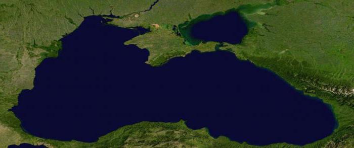
The territory of Russia is washed by 12 seas that belong to the basins of the Pacific, Arctic, Atlantic oceans, and the Caspian Sea-lake, which is located in the internal drainless basin of Eurasia.
The border within the Russian Federation between Europe and Asia conditionally runs along the Urals and throughout the Kumo-Manych depression. In some places, where the main ridge of the Urals is crossed by railways and highways, the border is marked by old stone obelisks or modern light memorial signs.
The center of Asia is located in Kyzyl, the capital of the Republic of Tuva. The eastern outskirts of Russia are located in the Western Hemisphere, since the 180th meridian passes through Wrangel Island and Chukotka.
The entire territory that lies west of the Urals belongs to the European part of Russia; it occupies about 23% of the area.
The Asian part of Russia owns more than 75% of the country's area. Despite this, 78% of Russia's inhabitants live in its European part, including the entire Urals.
Most of the country's territory is located between 70 ° N. and 50 ° N about 20% of the territory lies beyond the Arctic Circle.
Peculiarities of the geographical position of Russia - Cape Chelyuskin, located on the Taimyr Peninsula (77 ° 43'N), is the extreme northern point of the mainland, and the northernmost island point is Cape Fligeli, located on the island. Rudolph in the Franz Josef Land archipelago (81 ° 49´ N). From the North Pole, this point is only 900 km away.
Southwest of the city of Bazardzu, which is located in the eastern part of the Main (Dividing) ridge of the Greater Caucasus, on the border of Dagestan with Azerbaijan is the southernmost point of Russia (41 ° 11´ N).
More than 4000 km - the distance between the extreme southern and northern points... Along the meridian, this distance exceeds 40 °, and the southern point, from the northern mainland, is 36.5 ° away.
In the Gdansk Bay of the Baltic Sea, on the sandy Baltic Spit, in the Kaliningrad Region, there is the westernmost point of Russia. However, the Kaliningrad region is separated from the rest of Russia by the territory of other states. Therefore, the westernmost point of the main territory of Russia begins to the east, almost 500 km and lies slightly to the north of the point where the borders of Russia, Estonia and Latvia meet (27 ° 17'E).
The extreme continental eastern point is located on the Chukotka Peninsula - Cape Dezhnev (169 ° 40 'W). the extreme insular eastern point is located in the group of Diomede Islands, on about. Ratmanov (169 ° 02'W).
Peculiarities of the geographical position of Russia - The distance between the eastern and western extreme points of Russia (171 ° 20´) is almost 10,000 km.
What territory does it occupy? What are the main features of the geopolitical and economic-geographical position of Russia?
Basic information about Russia
The modern state of Russia appeared on the world map only in 1991. Although the beginnings of its statehood arose much earlier - about eleven centuries ago.
Modern Russia is a republic of the federal type. It consists of 85 entities, different in area and population. Russia is a multinational state in which representatives of more than two hundred ethnic groups live.
The country is the world's largest exporter of oil, gas, diamonds, platinum and titanium. It is also one of the world leaders in the production of ammonia, mineral fertilizers and weapons. The Russian Federation is one of the leading space and nuclear powers of the planet.
What are the main features This will be discussed further.
Geographical location area, extreme points and population
The country occupies a huge area of 17.1 million square meters. km (first place in the world in terms of territory). It stretches for ten thousand kilometers, from the shores of the Black and Baltic Seas in the west to the Bering Strait in the east. The length of the country from north to east is 4000 km.
The extreme points of the territory of Russia are as follows (they are all displayed by red conventional icons on the map below):
- northern - Cape Fligeli (within the Franz Josef Land);
- southern - near Mount Kichensuv (in Dagestan);
- western - on the Baltic Spit (in the Kaliningrad region);
- eastern - Ratmanov Island (in the Bering Strait).
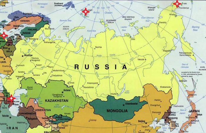
Russia directly borders on 14 independent states, as well as on two partially recognized countries (Abkhazia and South Ossetia). An interesting fact: about 75% of the country's territory is located in Asia, but almost 80% of Russians live in its European part. Total population of Russia: about 147 million people (as of January 1, 2017).
Physical and geographical position of Russia
The entire territory of Russia is located within the Northern Hemisphere of the Earth and almost all (with the exception of a small part of the Chukotka Autonomous Okrug) - within the Eastern Hemisphere. The state is located in the northern and central part of Eurasia and occupies almost 30% of Asia.
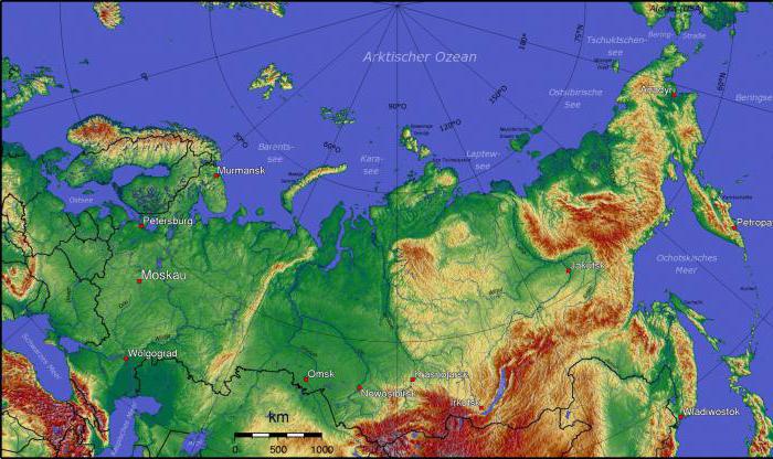
From the north, the shores of Russia are washed by the seas of the Arctic Ocean, and in the east - by the Pacific. In the western part, it has access to the Black Sea, which belongs to the basin Atlantic Ocean... The country has the longest length of any country in the world. coastline- over 37 thousand kilometers. These are the main features of the physical and geographical position of Russia.
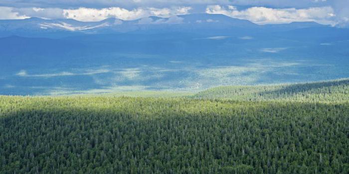
The country has a colossal wealth and diversity natural resource potential... Its vast expanses are home to the richest oil and gas fields, iron ore, titanium, tin, nickel, copper, uranium, gold and diamonds. Russia also possesses enormous water and forest resources. In particular, about 45% of its area is covered with forest.
There are others worth highlighting. important features physical and geographical location of Russia. So, most of the country is located north of 60 degrees north latitude, in the I zone, millions of people are forced to live in these difficult natural and climatic conditions. All this, of course, left its mark on the life, culture and traditions of the Russian people.
Russia is in the area of so-called risky farming. This means that the successful development of agriculture in most of it is difficult or impossible. So, if in the northern regions of the country there is not enough heat, then in the southern regions, on the contrary, there is a deficit of moisture. These features of Russia's geographical position have a noticeable effect on the agro-industrial sector of its economy, which is in dire need of government subsidies.
Components and levels of the country's economic and geographical position
These are, perhaps, the main features of the geographic location of Russia of an economic nature. How has it changed in recent decades? And has it changed?
After the collapse of the USSR, the country's economic and geographical position deteriorated markedly. And above all transport. After all, Russia's access to the strategically important waters of the Black and Baltic Seas in the early 1990s was significantly limited, and the country itself was several hundred kilometers away from the highly developed states of Europe. In addition, Russia has lost many of its traditional sales markets.
Geopolitical position of Russia
Geopolitical position is the place of the country in the world political arena, its relations with other states. In general, Russia has ample opportunities for economic, political, military, scientific and cultural cooperation with many countries of Eurasia and the planet.
However, these relations are not developing in the best way with all states. So, in last years Russia's relations with a number of NATO countries - the Czech Republic, Romania, Poland, which were once close allies Soviet Union... This fact, by the way, is called the largest geopolitical defeat of the Russian Federation in the new century.
Russia's relations with a number of post-Soviet states remain complex and rather tense: Ukraine, Georgia, Moldova, and the countries of the Baltic region. The geopolitical position of the country changed significantly in 2014 with the accession Crimean peninsula(in particular, in the Black Sea region).
Changes in the geopolitical position of Russia in the twentieth century
If we look at the twentieth century, then the most tangible change of power in the European and world political arena took place in 1991. The collapse of the powerful state of the USSR entailed a number of fundamental changes in the geopolitical position of Russia:
- more than a dozen young and independent states with whom it was necessary to establish a new type of relationship;
- the Soviet military presence was finally eliminated in a number of countries in Eastern and Central Europe;
- Russia received a rather problematic and vulnerable enclave - the Kaliningrad Oblast;
- The NATO military bloc gradually approached directly to the borders of the Russian Federation.
At the same time, over the past decades, fairly strong and mutually beneficial ties have been established between Russia and Germany, China, Japan, and India.
As a conclusion: Russia in the modern world
Russia occupies a vast territory, possessing colossal human and natural resource potential. Today it is the largest state on the planet and an important player in the global arena. The most important features of the geographical location of Russia can be identified, here they are:
- The vastness of the occupied space and the enormous length of the borders.
- A stunning variety of natural environments and resources.
- Mosaicity (unevenness) of settlement and economic development of the territory.
- Ample opportunities for trade, military and political cooperation with various neighboring states, including leading economies modern world.
- The volatility and instability of the country's geopolitical position over the past decades.
The peculiarities of the geographic location of Russia are extremely advantageous. But it is important to learn how to use these benefits (natural, economic, strategic and geopolitical) correctly and rationally, directing them to increase the power of the country and the well-being of its citizens.
IntroductionThe emergence of economic geography in Russia dates back to the middle of the 18th century. and is associated with the economic and political successes of the country, the expansion of its territory, the creation of an all-Russian market.
Since the time of Peter the Great's reforms in Russia, a colossal growth of industry for those times begins, many of its branches acquire world significance... In the second half of the 18th century. Russia's foreign trade turnover is increasing fivefold. Domestic trade is growing even faster - the total volume of fair trade in 1818 is five times the volume of foreign trade. With the expansion of the borders of Russia in the East, the Caucasus, in the Black Sea region, with the inclusion of Poland and Finland, Moscow trade along new distant routes (improved dirt roads connecting important settlements) reaches the Okhotsk and Black Seas, penetrates into the deep mountain valleys of the Caucasus and oases Central Asia... In the middle of the 18th century. internal customs are eliminated; at the same time, the first banks appeared in the country. The scope of economic ties that covered the rapidly expanding territory of the country, the development of science and culture, new state tasks required a comprehensive study of the features of nature, economy, the population of all parts of the gigantic territory of the country, the creation of maps and atlases, the compilation of complex, i.e. including nature, economy, and population, descriptions of Russia as a whole and its individual parts, including newly developed ones, elimination of "white spots" on the map of the country, clarification in the ideas about the location and configuration of rivers, sea shores, straits, islands, about the presence and nature of routes to distant countries.
The purpose of this work is to study the features of the geographic location of Russia.
The total length of the borders of the Russian Federation is 60,000 km, of which 40,000 km are sea borders. The maritime boundaries are 12 nautical miles (22.7 km) offshore. The borders of the Russian maritime economic zone are located 200 nautical miles (370 km) from the coasts of the islands and the mainland. Within this zone, shipping of any country is allowed, but the development and production of all types natural resources located in the waters, at the bottom and in the bowels, is carried out only by Russia.
The northern maritime borders of Russia pass through the waters of the seas of the Arctic Ocean (Barents Sea, Kara Sea, Laptev Sea, East Siberian Sea, Chukchi Sea). Except part Barents Sea all of them are covered with drifting ice all year round, so navigation on the seas is difficult. Our sector of the Arctic is located within the Arctic Ocean from the shores of Russia to the North Pole. All the islands in this sector, except for a few islands in the Svalbard archipelago, belong to our country.
Eastern borders pass through the waters of the Pacific Ocean and its seas (Bering Sea, Sea of Okhotsk, Sea of Japan). The closest maritime neighbors are Japan and the United States. The La Perouse Strait separates Sakhalin Island from Hokkaido Island in the Sea of Japan (it does not freeze, which favors Russia's maritime ties with its neighbors).
Sea boundaries in the west. The waters of the Baltic Sea connect Russia with Sweden, Poland, Germany and the Baltic countries. The northern part of the Baltic Sea freezes on some Russian shores, but does not freeze off the shores of Kaliningrad. By Baltic Sea communication is carried out with many states of Western Europe.
In the south-west of the Russian Federation, sea borders run along the waters of the Azov and Black Seas, which connect Russia with Ukraine, Georgia, Bulgaria, Turkey, Romania. The Black Sea routes lead to the Mediterranean Sea. Small in length sea borders run along the Caspian Sea.
Conclusion
In conclusion, it should be noted that Russia occupies a vast territory, possessing colossal human and natural resource potential. Today it is the largest state on the planet and an important player in the global arena. The most important features of the geographical position of Russia can be identified, here they are: The vastness of the occupied space and the huge length of the borders. A stunning variety of natural environments and resources. Mosaicity (unevenness) of settlement and economic development of the territory. Ample opportunities for trade, military and political cooperation with various neighboring states, including the leading economies of the modern world. The volatility and instability of the country's geopolitical position over the past decades. The peculiarities of the geographic location of Russia are extremely advantageous. But it is important to learn how to use these benefits (natural, economic, strategic and geopolitical) correctly and rationally, directing them to increase the power of the country and the well-being of its citizens.
Bibliography
1. Geography of Russia. Textbook / Under. Ed. A. V. Darinsky, B. V. Belousov, I. N. Belkina. -2015.-349s.
2. Tarakanov G.I. "Features of the influence of political and geographical factors on economic growth" // Problems of modern economics. 2014. No. 4 (24).
3. Economical geography Russia. Tutorial by geography / Under. Ed. I. A. Radionova -2012.-359s.
4. Economic geography. Moscow: graduate School, 1999.-362s.
Tarakanov G.I. "Features of the influence of political and geographical factors on economic growth" // Problems of modern economics. 2014. No. 4 (24).
Geography of Russia. Textbook / Under. Ed. A. V. Darinsky, B. V. Belousov, I. N. Belkina. -2015.-349s.
Economic geography of Russia. Textbook on geography / Under. Ed. I. A. Radionova -2012.-359s.
Geographical position includes three components - physical and geographical position, economic and geographical and and means the peculiarities of the position of a country or other geographic feature on physical, economic and.
A serious issue is relations with Muslim states on the southern borders of Russia, as well as with the countries of the South.
As a result of the collapse of the USSR, the length of Russia's borders is now 60,933 km. Thus, almost 2/3 of Russia's borders are maritime. Our country has the longest land border with Kazakhstan (41% of the entire land border of Russia), (about 20%) and (10% of the land border of Russia).
Assessing the geographical position of the country, one cannot ignore such a concept as "vastness". Russian territory is enormous. There are countries that you can walk in a few hours (,). You can travel by car in a day,. You can cross Russia from west to east in a day only by plane.
Unfortunately, our age of high speeds has changed the previous perception of space and distance. In the XIX century. French writer Germaine de Stael wrote about the spaces of Russia: “Russia is the threshold of another, unknown land of the East. In Russia there is such space that everything in it is lost, even palaces, even the population itself. Everything drowns in an immense space, it reigns over everything and captures the imagination. "
The territory of Russia is difficult to imagine also because there are no countries in the world that are similar in size to it. For example, the area of the United States (9.4 million km2) is 55% of the area of Russia, and the area of all states overseas Europe- 35% of the area of our country.
1% of the territory of Russia (for example, republics, Tuva) is the area of countries such as or; 2% (for example, the Republic of Buryatia, Amur region) - it