More than 2.5 million rivers flow through the territory of Russia. The overwhelming majority of them (94.9%) have a length of 25 km or less. The number of medium rivers, 101 to 500 km long, is 2833 (0.1%), the number of large rivers is 214 (0.008%).
Russian rivers belong to the basins of three oceans: the Arctic, Pacific and Atlantic. In addition, some of the rivers flow into internal seas and lakes not connected with the World Ocean.
More than half of the territory of Russia (65%) belongs to the basin of the Arctic Ocean, its marginal seas (Barents, White, Kara, Laptev, East Siberian and Chukchi). The main, central part of this basin is occupied by the main arteries of the country - the Ob, Yenisei and Lena rivers, between which the basins of the Taz, Pur, Pyasina, Khatanga and others are located. The basins of the Pechora, Northern Dvina and Onega, to the east - the basins of the Yana, Indigirka, Kolyma, etc.
The Pacific Ocean basin owns about 19% of the territory of Russia. River runoff enters the marginal seas of the Pacific Ocean - Bering, Okhotsk and Japanese. The Anadyr and Kamchatka rivers flow in the northern part of the basin, and the Amur - in the southern part. Rivers in the mid-Pacific Basin are short streams with small basin areas.
To the pool Atlantic Ocean includes about 5% of the area of Russia, this includes the river network belonging to the basins of the Baltic, Black and Azov seas. The largest rivers of the Baltic basin are the Neva, Narva, Western Dvina, Neman; the Black Sea basin - the Dnieper River; pool Sea of Azov- rivers Don, Kuban.
The area of the Caspian closed drainage area is 11% of the territory of Russia. It includes such large rivers like Volga, Ural, Terek.
The watershed between the basins of the Arctic and Pacific oceans runs along the Chukotka ridge, Anadyr plateau, mountain ranges: Kolymsky, Dzhugdzhur, Stanovoy and Yablonovoy. The watershed of the endless Caspian basin is formed by the Sayan and Altai mountain systems, and the Atlantic Ocean - by the Ural Mountains, Northern Uvaly and the Maanselka Upland.
The watershed between the Atlantic Ocean basin and the Caspian basin runs along the Valdai, Central Russian, Volga and Stavropol Uplands, along the Main Caucasian Range.
Rivers are unevenly distributed on the territory of Russia. In the desert areas of the Caspian region, in some places there are no rivers at all, and in the mountains of the Caucasus, mountain systems Altai and Eastern Siberia there are a lot of them.
The peculiarity of the structure of the river network in Russia lies in the predominantly meridional direction of the flow of most of the large rivers. Average density of the river network Russian Federation, which is an indicator of the watering of the territory, is equal to 0.49 km per 1 km2.
Most of the rivers carry their waters to the Arctic (64%) and Pacific Oceans (27%). In the Azov-Black Sea (1%) and Caspian basins (7%), there are only 193942 rivers. To the pool Baltic Sea accounts for less than 2% of the total number of rivers in Russia.
The five largest rivers in Russia have a catchment area exceeding 1000 thousand km2. First of all, this is the Ob River, which collects water from a vast basin with an area of 2990 thousand km2. The catchment areas of the Yenisei, Lena and Amur rivers are respectively 2580, 2490 and 1855 thousand km2. The Volga, the first largest river in Europe, occupies only the fifth place among Russian rivers in terms of basin area (1360 thousand km2).
The largest in length is the Ob River (with the Irtysh), the length of which, if (the Irtysh River is taken as its source), is 5570 km. The Lena, Yenisei and Amur rivers are over 4000 km long.
The rivers Volga, Kolyma, Ural and Olenek are over 2000 km long.
In terms of water content, the Yenisei occupies the first place among the rivers of Russia with an average annual water discharge of 19870 m3 / s and an average long-term annual flow of 630 km3.
The Ob, which has the largest catchment area, is inferior in water content not only to the Yenisei, but also to the Lena: the average annual water discharge of the Lena River is 16300 m3 / s, and the Ob - 12600 m3 / s. The relatively low specific water content of the Ob River is explained by the fact that in the southern part of its basin there are vast inner drainage areas and territories with low surface runoff.
Among the world's largest rivers in terms of flow, the Yenisei, Lena, Ob, Amur and Volga occupy the fifth, seventh, twelfth, fourteenth and fifteenth places, respectively.
Currently, on the territory of Russia, there are about 60 large (with a flow rate of more than 100 m3 / s) earthen canals, laid in various geological and climatic conditions... Many of them are complex channels. Extensive experience has been accumulated in the construction and design of canals in the south of Russia, in the Urals, in Western Siberia... The largest canals in Russia are: Volgo-Caspian, White Sea-Baltic, im. Moscow, Volga-Don land, Bolshoy Stavropol, Tersko-Kumsky, Nevinnomyssky. 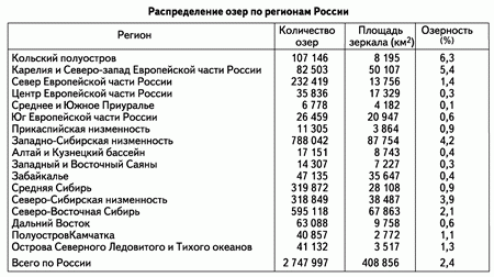 On the territory of Russia, there are more than 2.7 million lakes with a total water surface area of 408 856 km2. Among them, only 19 lakes have a surface area exceeding 1000 km2. The total area of the surface of these lakes is 108,065 km2.
Most of the lakes (98%) are small (surface area less than 1 km2) and shallow (depth 1–1.5 m). Almost all lake water reserves are concentrated in several large reservoirs. Thus, the volume of Lake Baikal, which is 23 thousand km3, is 5 times higher than the total annual flow of all rivers of Russia.
On the territory of Russia, the lakes are distributed extremely unevenly. In some areas they are quite rare, but in others they occupy a significant part of the surface - sometimes up to 10-50% of the total area of the area. There are ten lake regions within Russia.
V Northwest region along with numerous small and medium-sized lakes, there are such large ones as Ladoga, Onezhskoe, Beloe, Ilmen, Chudskoe, Pskovskoe, Vygozero, Segozero, Kovdozero, Pyaozero, Imandra. Most of the lakes are of glacial origin. Tectonic lakes are also widespread. This type includes many lakes in Karelia and Kola Peninsula... In places of shallow bedding of easily soluble rocks, there are karst lakes. Azovo-Chernomorsky district characterized by a large group of peculiar lakes located along the coast. Their origin is associated with the activity of the sea, mainly they are estuaries (Yeisk, Beisug, etc.). Most lakes Caspian region, covering the Caspian lowland, it feeds on the flooding of steppe rivers during spring floods. Temporary water bodies are typical, but there are also large lakes - Elton, Baskunchak, Chelkar, Sarpinsky lakes, etc. West Siberian region, including the steppe and forest-steppe zones of the West Siberian Lowland, there are several tens of thousands of lakes. As a rule, they are small and represent flat saucer-shaped depressions of suffusion origin. Lakes Altai region They are developed mainly in the crimson basins, they are distinguished by their rounded outlines and small size. The largest of them are Teletskoe and Marka-Kul. Most of the lakes of the Trans-Baikal region are remnants of the disappeared larger bodies of water - Zun-Torey, Barun-Torey, etc. Nizhneamurskiy district, encompassing the lowland that accompanies the lower course of the Amur River, there are many large, but shallow, lakes (Orel, Chukchagirskoe, Kizi, etc.). Yakutsk Lake District is located on the territory of the Leno-Vilyui lowland and the Leno-Amginek watershed. There are several tens of thousands of small lakes of thermokarst origin here. Pripolyarnomorskiy region includes the tundra zone of the coast of the Arctic Ocean teeming with lakes. The origin of the lakes is predominantly thermokarst. Most lakes Kamchatka region are volcanic and located in craters and calderas of extinct volcanoes. Despite their small size, they differ in significant depths. The largest of the lakes are Kurilskoye and Kronotskoye. There are lakes of a different origin - lagoon type (for example, Lake Nerpichye at the mouth of the Kamchatka River).
To answer the question of which rivers belong to the Atlantic Ocean basin, you can list a huge number of rivers in Europe, Russia and North America... But since this is too long a list, we will only indicate the water streams flowing through our country.

With a relatively short length (only about 74 km), the catchment area of the river is 28 thousand square kilometers, since it is the only one flowing from Lake Ladoga... The total fall is 5.1 m.
The river basin is a complex hydrological network with a large number of lakes and reservoirs. In total, the drainage area of the Neva includes over 48 thousand rivers and more than 26 thousand lakes. At the same time, 26 tributaries flow directly into the river.
These are also rivers of the Atlantic Ocean basin, the largest of which on the left bank are the Staro- and Novo-Ladoga canals, Mga, Izhora, Tosna, Slavyanka, and on the right - the Chernaya and Okhta rivers. In the delta, it is divided into several ducts connected by canals.
With a length of 74 km, the discharge of the Neva is 78.9 cubic kilometers per year, which makes it one of the ten largest rivers in Europe. The average width is 400-600 m, and the average depth is 8-11 m.
Rivers of the Atlantic Ocean basin (list)
And now we list all the rivers included in the Atlantic Ocean basin:
- Don and tributaries: Seversky Donets, Voronezh, Tikhaya and Bystraya Sosny, Manych, Aksai, Nepryadva, Bear, Tchernaya Kalitva, Beautiful Sword, Bityug, Chir, Ilovlya, Osered, Sal.
- Kuban and tributaries: Big and Small Zelenchuk, Teberdya, Laba, Urup, Pshish, Belaya, Afips, Psekups (left bank), Mara, Dzheguta, Gorkaya (right bank).
- Neva and tributaries: Staro- and Novo-Ladoga canals, Mga, Izhora, Tosna, Slavyanka, and on the right, Chernaya and Okhta.
Telling which rivers belong to the Atlantic Ocean basin, in general, it can be argued that all of them are fed mainly by snow. Their course is calm, and for the most part they are quite deep. Although in our country, by the way, they are not the largest, as in Eurasia. The richest rivers are the Arctic Ocean.
Now, we hope, it will not be difficult for you to answer the question which rivers belong to the Atlantic Ocean basin in Russia.
Preparation for ZNO. Geography.
Abstract 12. Geography of the continents. Eurasia
Geographical position
The continent is located in the Northern Hemisphere between 9 ° W. d. and 169 ° W etc., some of the islands of Eurasia are located in Southern hemisphere... Most of the mainland lies in the Eastern Hemisphere, although the extreme western and east point the mainland are in the Western Hemisphere. Contains two parts of the world: Europe and Asia... The continent is united by the continuity of the land, currently formed by tectonic consolidation and the unity of numerous climatic processes. This is the only continent on Earth, washed by four oceans: in the south - Indian(the largest currents are warm: Musonic flow), in the north - Northern Arctic, in the West - Atlantic Canary; warm: North Atlantic, Norwegian), in the east - Quiet(the largest currents are cold: Kuril; warm: Kuroshio).
Extreme points:
north - Cape Chelyuskin(77 ° 43 "N, 104 ° 18" E);
southern - Cape Piai(1 ° 16 "N, 103 ° E);
western - Cape Roca(38̊ ° 46 "N, 9̊ ° 29" W);
eastern - Cape Dezhnev(66 ° 04 "N, 169 ° 39" E).
Eurasia stretches from west to east for 18 thousand km, from north to south - for 8 thousand km, with an area of 54 million km ². This is more than a third of the entire land area of the planet.
Relief and tectonic structure
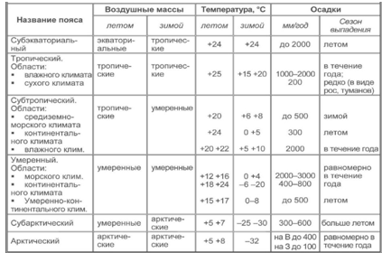
Climate and inland waters
The mainland is rich inland waters.
Rivers of Eurasia belong to the basins of the four oceans and the basin of internal flow.
They flow into the Pacific Ocean such large rivers of Eurasia as Cupid, Yellow River, Yangtze(the most long river Eurasia), Mekong.
They flow into the Indian Ocean the next major rivers of Eurasia - Indus, Ganges(the most deep river Eurasia), Brahmaputra, Ayeyarwaddy, Soluin, Tigris, Euphrates.
They flow into the Atlantic Ocean such large rivers: Danube, Dnieper, Don, Elbe, Oder (Odra), Rhine, Seine, Loire, Vistula.
The following flows into the Arctic Ocean: Ob, Yenisei, Lena, Kolyma.
To the internal drainage basin the longest river in Europe belongs - Volga, as well as the region of Central Asia and the central part of the Arabian Peninsula.
Lakes of Eurasia. There are many lakes in Eurasia. The largest closed lake in the world - Caspian Sea(has a relict origin, belongs to the internal drainage basin). The deepest and largest freshwater lake in the world Baikal (tectonic origin). The most salt Lake the world The Dead Sea(has a tectonic origin, belongs to the basin of internal flow). Highly interesting lake Balkhash- the water in one part of the lake is fresh, and in the other it is salty (the reason for the peculiarities of the climate).
Natural areas

Population and countries of Eurasia
Eurasia is the most populated continent, its population is three quarters of the population of the entire planet. Racial and ethnic composition the population of Eurasia is very complex, which is associated with centuries-old processes of resettlement of peoples as a result of campaigns of conquest, internecine wars, natural disasters, displacement of national minorities. Eurasia is the birthplace of two main human races - Caucasoid and Mongoloid... Caucasians make up 45% of the mainland's population. On the territory of Eurasia, the population is distributed extremely unevenly, which is influenced by the peculiarities of nature and the historical settlement of the territories. The following regions have the highest density: Western Europe, Eastern China and the Indo-Gangetic Valley.
The largest states of Eurasia by area - Russia, China, India, Kazakhstan.
In terms of population, the absolute leaders are China and India... Each of these countries has a population of over 1 billion people.
There are seven "dwarf" states in Eurasia.
The most developed countries are located in Western Europe, among them there are world leaders, in particular Germany, France, UK, Italy.
In Asia, the most developed country is Japan... Other states are developing, but the degree of their economic achievements is different. China, India, South Korea, Singapore. In addition, the mainland also has the countries with the lowest economic development(Bhutan, Nepal, Laos, Bangladesh, Afghanistan, etc.).
Online test of preparation for ZNO in geography
Glorified by many writers and poets of Russia.
The Don River originates in Tula region for a long time there were heated debates about the source. Initially, the source was considered a small lake Ivan, located in the Tula region, but when it was possible to establish that the water does not come out of the lake, the reservoir of the city of Novomoskovsk (all in the same Tula region) was called the source. But this hypothesis was not confirmed, since from the side of the Don the reservoir is fenced off by a powerful dam. As a result, the exact place of birth of the great Russian river was established, it was a very small rivulet Urvanka, flowing a few kilometers from Novomoskovsk. Thus, the Don originates in the northern part of the Central Russian Upland.
The length of the Don is one thousand nine hundred and seventy kilometers (1970 km.), The basin area is about four hundred twenty thousand square kilometers (420,000 km2). Having originated in the Central Russian Upland, the Don smoothly turns into flat areas and natural areas, therefore, the flow of the river is quiet, calm, slow. Along the entire length of the Don, it is replenished at the expense of numerous tributaries, according to the most conservative estimates, about five thousand two hundred rivers flow into the Don, not counting small streams. Most large tributaries The Don rivers are: Voronezh, Seversky Donets, Bystraya Pine, Quiet Pine, Aksai, Manych, Medveditsa, Nepryadva, Beautiful Sword, Black Kalitva, Chir, Bityug, Osered, Ilovlya, Sal, they all have their own tributaries. The Don flows into the Taganrog Bay.
Don flows through the territory of Kursk, Belgorod, Oryol, Tula, Ryazan, Tambov, Penza, Saratov, Volgograd, Lipetsk, Voronezh regions, Rostov regions of the Russian Federation. The Don flows through the territory of Kharkov, Donetsk, Lugansk regions. The riverbed meanders strongly between hills and uplands. On South Voronezh region(Verkhnemamonsky district) the channel turns and changes direction, it turns out that the river flows to the north for several kilometers. This is a very rare case, uncharacteristic for the rivers of the Central Russian Upland.
The right bank of the Don is steep and steep almost along its entire length, it consists of chalk and stony deposits. The left bank, on the contrary, is gentle and. The left part of the Don basin has a huge amount, which are flooded during floods, wetlands, and also occur. In the steppe zone, the left bank is overgrown with grasses.
The Don bed is usually divided into three sections: the Upper Don, the Middle Don and the Lower Don. TO Upper Don include the site from the mouth to the tributary of the Tikhaya Sosna River. The course of the upper reaches of the Don is quite fast (compared to the Middle and), there are rifts and whirlpools. Four tributaries are connected to the Upper Don: Nepryadva (right tributary), Beautiful Mecha (right tributary), Pine (right tributary) and Voronezh (left tributary). The depth of the Don in this area rarely exceeds one and a half meters, of course there are pits of several meters, but they are quite rare.
Middle Don starts from Quiet Pine and ends with Tsimlyanskiy. On this site, the following rivers flow into the Don: Chornaya Kalitva (right tributary), Bogucharka (right tributary), Bityug (left tributary), Khoper (left tributary), Medveditsa (left tributary), Ilovlya (left tributary). Here the Don flows slowly, the average depth is one and a half meters, there are quite deep pits, some of them reaching thirteen to fifteen meters deep. In the middle of the twentieth century, the Volga-Don Canal was built, connecting two great Russian rivers. The construction of the canal was started in the Kalacheyevsky district of the Voronezh region, where the bed of the don approaches the channel quite close (at a distance of eighty kilometers).

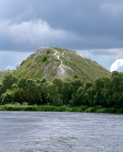
Don River (photo by Anastasia Chernikova)
Lower Don starts from the reservoir and ends with the place where it flows into the Taganrog Bay. The river delta begins from the city of Rostov-on-Don, where the channel is divided into a huge number of channels. In the Lower section, the Don receives the following tributaries: Seversky Donets (right tributary), Sal (left tributary), Manych (left tributary). In the lower reaches of the Don, the widest, the depth is several meters, the pits reach fifteen to seventeen meters.
The Don receives the bulk of the water, about seventy percent, as a result of snow melting, the remaining thirty percent comes from water and rain. The river freezes in early December, and opens up in March - early April. Thus, the river remains unnavigable for four months. Only the Nizhny and Sredny Don is navigable, the last river port where ships enter is located in the town of Liski, Voronezh region. Thus, most of the river is used as a line (approximately one thousand six hundred kilometers).
![]()
Delta of the Don River, which flows into the Taganrog Bay. Satellite view
The waters of the Don are rich in various types of freshwater fish: crucian carp, carp, bream, rudd, roach, bleak, sabrefish, pike perch, pike, perch, catfish, burbot, ide ... Sterlet comes to the Middle Don during spawning, and before the construction of the Tsimlyansk reservoir there were also beluga. Fish is not caught on an industrial scale, but sports fishing enthusiasts are ubiquitous on the banks of the great Russian river.