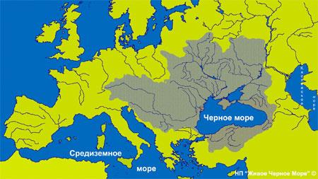
From 35 million years ago to the present, a basin has been formed. Black Sea Inland Sea Basin Atlantic Ocean... The Bosphorus Strait connects with the Sea of Marmara, then, through the Dardanelles Strait, with the Aegean and Mediterranean Seas. The Kerch Strait connects with Sea of Azov... Cuts deep into the sea from the north Crimean peninsula... The water border between Europe and Asia Minor runs along the surface of the Black Sea.
Length 1150 km
Width 580 km
Area 422,000 km²
Volume 547,000 km³
Length coastline 3400 km³
Maximum depth 2210 m
Average depth 1240 m
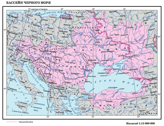
The catchment area is more than 2 million km²
Black sea map
Salinity map of the Black Sea
The salty taste of sea water is due to sodium chloride, and the bitter taste is from magnesium chloride and magnesium sulfate. Water contains 60 different elements. But it is assumed that it contains all the elements found on Earth. Sea water has a number of medicinal properties. The salinity of the water is about 18%.
Rivers flowing into the Black Sea
Due to the excess inflow of fresh waters of the rivers Agoy, Ashe, Bzugu, Bzyp, Veleka, Vulan, Gumista, Dnieper, Dniester, Danube, Yeshilyrmak, Inguri, Kamchia, Kodor, Kyzylirmak,
Kyalasur, Psou, Reprua, Rioni, Sakarya, Sochi, Khobi, Chorokhi, Southern Bug.
(more than 300 rivers) above evaporation it has a lower salinity than the Mediterranean Sea.
The rivers bring 346 cubic meters to the sea. km of fresh water and 340 cubic meters. km of salt water flows out of the Black Sea through the Bosphorus.
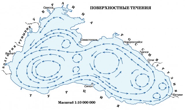
Black Sea current
International experts claim that the natural cyclonic circulation of waters in the Black Sea - the so-called "Knipovich glasses" - cleanses the sea in a natural way.
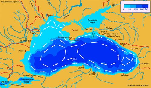
Of particular interest is the question of the Black Sea currents. In the Black Sea, there is a main closed ring of current, 20 to 50 miles wide, running 2-5 miles counterclockwise from the coast, and several connecting jets between its separate parts. The average current speed in this ring is 0.5-1.2 knots, but with strong and stormy winds it can reach 2-3 knots. In spring and early summer, when rivers bring large amounts of water to the sea, the current intensifies and becomes more stable.
The flow under consideration originates at the mouths big rivers and in the Kerch Strait. River waters, flowing into the sea, leave to the right. Then the direction is formed under the influence of wind, coastal configuration, bottom topography and other factors. From Kerch Strait the current goes along Crimean coast... At the southern tip, a split occurs. The main current goes north to the mouth of the Dnieper-Bug estuary, and part of it goes to the Danube banks. Having received the Dnieper and then Dniester waters, the main current goes to the Danube, and then to the Bosphorus. Strengthened by the Danube waters and the Crimean branch, it is gaining the greatest strength here. From the Bosphorus, the main branch of the current, having given part of the water to the Sea of Marmara, turns to Anatolia. The prevailing winds here favor the eastward direction. At Cape Kerempe, one branch of the current deviates to the north towards the Crimea, while the other goes further to the east, absorbing the flow of the rivers of Asia Minor. At the Caucasian shores, the current turns to the northwest. Near the Kerch Strait, it merges with the Azov current. And on the southeastern coasts of Crimea, division is taking place again. One branch descends to the south, diverges with the current flowing from Cape Kerempe, and in the Sinopa region it connects with the Anatolian current, closing the East Black Sea circle. And another branch of the current from the southeastern shores of the Crimea goes to its southern end. Here the Anatolian current flows into it from Cape Kerempe, which closes the western Black Sea circle.
Underwater river in the Black Sea
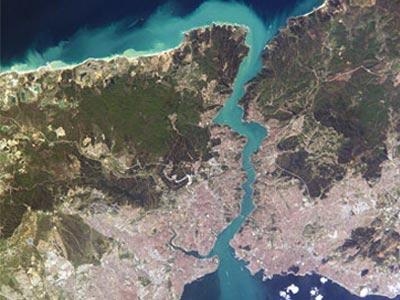
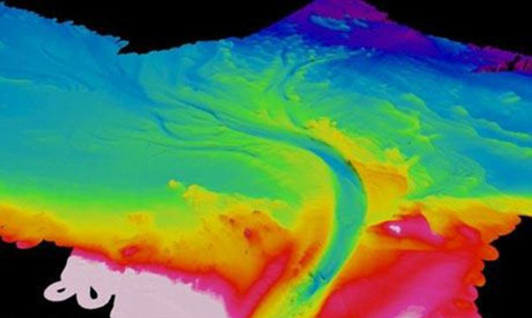
An underwater river in the Black Sea is a bottom flow of highly salty water from the Sea of Marmara across the Bosporus and along the seabed of the Black Sea. The trench through which the river flows is about 35 m deep, 1 km wide and about 60 km long. The speed of the water flow reaches 6.5 km / h, that is, 22 thousand m³ of water passes through the canal every second. If this river flowed on the surface, then it would be the sixth in the list of rivers in terms of full flow. The submarine river contains elements characteristic of surface rivers, such as banks, floodplains, rapids and waterfalls. Interestingly, the eddies in this underwater river do not twist counterclockwise (as in ordinary rivers of the Northern Hemisphere due to the Coriolis force), but along it.
The channels at the bottom of the Black Sea were supposedly formed 6 thousand years ago, when the sea level was approaching its current position. The waters of the Mediterranean Sea broke into the Black Sea and formed a network of gutters that are still active today.
The water in the river has a higher salinity and concentration of sediments than the surrounding water, so it flows down by gravity and possibly supplies nutrients to the abyssal plains that would otherwise be lifeless.
The river was discovered by scientists from the University of Leeds on August 1, 2010, and is the first such river to be discovered. On the basis of sonar sounding, it was previously known about the existence of channels on the ocean floor, and one of the largest such channels stretches from the mouth of the Amazon to the Atlantic Ocean. The assumption that these channels can be rivers was confirmed only with the discovery of an underwater river in. The strength and unpredictability of such streams makes it impossible to study them directly, so the scientists used autonomous underwater vehicles.
Transparency of sea water
The transparency of seawater, that is, the ability to transmit light rays, depends on the size and amount of suspended particles of various origins in the water, which significantly change the penetration depth of light rays. Distinguish between absolute and relative transparency of seawater.
By relative transparency is meant the depth (measured in meters) at which a white disk 30 cm in diameter disappears. Absolute transparency is the depth (measured in meters) to which any of the rays of light from the solar spectrum can penetrate. It is believed that in clear sea waters this depth is approximately 1000 to 1700 m.
Table of relative transparency of the waters of the World Ocean
Atlantic Ocean, Sargasso Sea to 66
Atlantic Ocean, equatorial zone 40 - 50
Indian Ocean, trade wind zone 40 - 50
Pacific Ocean, trade wind zone up to 45
Barents Sea, south Western part up to 45
Mediterranean Sea, off the African coast 40 - 45
Aegean up to 50
Adriatic Sea around 30 - 40
Black Sea about 30
Baltic Sea, off Bornholm Island 11 - 13
North Sea, English Channel 6.5 - 11
Caspian Sea, southern part 11-13
Results of expeditions on the research vessel "Professor Vodyanitsky" (2002-2006)
If the methane release is deep enough under water, the gas is bound in the composition " warm ice". But sometimes free, very powerful gas outbursts break through the stratum of gas hydrates.
Sometimes such a "methane fountain" beats for days, months ... or even begins to "work" periodically, then calming down, then again breaking through to the surface of the sea. Such phenomena are called mud volcanoes, because gas, rushing upward from the bottom, takes with it masses of bottom soil, stones, water ...
In many places, much more modest jets of methane rise from the bottom, spreading in clouds. We call them - vultures. Some of them emit gas in an even, constant stream, others - pulsate, resembling a puffing pipe of a smoker ... There are a lot of sips in the Kerch-Taman region, and off the coast of the Caucasus, and near the coasts of Georgia, Bulgaria ...
Gas torch of methane on the shelf of the Black Sea, emerging to the surface of the water
![]()
Black Sea- the inland sea of the Atlantic Ocean. The Bosphorus Strait connects with the Sea of Marmara, then, through the Dardanelles Strait, with the Aegean and Mediterranean Seas. The Kerch Strait connects with the Sea of Azov. The Crimean Peninsula cuts deep into the sea from the north. The water border between Europe and Asia Minor runs along the surface of the Black Sea.
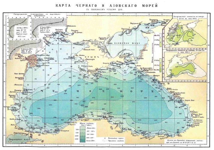
Area 422,000 sq. Km. The outlines of the Black Sea resemble an oval with a longest axis of about 1150 km. The greatest length of the sea from north to south is 580 km. Maximum depth - 2210 m, average - 1240 m.
The only large peninsula is the Crimean one. The largest bays are: Yagorlytsky, Tendrovsky, Dzharylgachsky, Karkinitsky, Kalamitsky and Feodosia in Ukraine, Varnensky and Burgas in Bulgaria, Sinop and Samsunsky - near the southern coast of the sea. Estuaries overflow in the north and north-west at the confluence of rivers. The total length of the coastline is 3400 km.
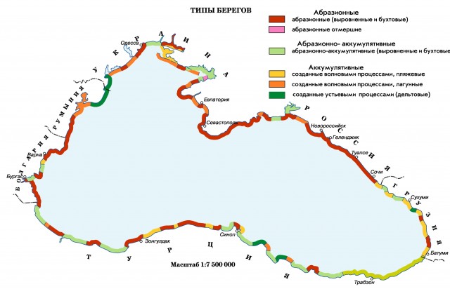
A number of sections of the sea coast have their own names: the southern coast of Crimea, the Black Sea coast of the Caucasus in Russia, the Rumeli coast and the Anatolian coast in Turkey. In the west and northwest, the shores are low-lying, steep in places; in Crimea - mostly low, with the exception of the southern mountainous shores. On the eastern and southern shores, the spurs of the Caucasus and Pontic mountains come close to the sea.
There are practically no islands in the Black Sea. The largest are Berezan and Zmeiny (both with an area of less than 1 sq. Km).
The following major rivers flow into the Black Sea: Danube, Dnieper, as well as smaller Rioni, Kodori, Inguri (in the east of the sea), Chorokh, Kyzyl-Irmak, Ashli-Irmak, Sakarya (in the south), Southern Bug and Dniester (in the north ).
The fauna of the Black Sea is noticeably poorer than the Mediterranean. The Black Sea is home to 2.5 thousand species of animals (of which 500 species of unicellular, 160 species of vertebrates - fish and mammals, 500 species of crustaceans, 200 species of molluscs, the rest - invertebrates different types), for comparison, in the Mediterranean - about 9 thousand species.
Among the fish found in the Black Sea: various types of gobies (bighead goby, whip goby, round goby, martovik goby, sleeper goby), Azov hamsa, Black Sea hamsa (anchovy), katran shark, gloss flounder, five species of mullet, bluefish, hake, sea ruff, red mullet (common Black Sea sultan), haddock, mackerel, horse mackerel, Black Sea-Azov herring, Black Sea-Azov tulka, etc. There are sturgeons (beluga, Black Sea-Azov sturgeon).
Among the dangerous fish of the Black Sea are the sea dragon (the most dangerous are the poisonous spines of the dorsal fin and gill covers), the Black Sea and noticeable scorpion fish, the stingray stingray (sea cat) with poisonous thorns on its tail.
The largest port cities on the Black Sea:
Burgas, Varna (Bulgaria);
Batumi, Poti (Georgia);
Novorossiysk, Sochi, Tuapse (Russia);
Constanta (Romania);
Samsun, Istanbul, Trabzon (Turkey);
Odessa, Kherson, Ilyichevsk (Ukraine)
Kerch, Sevastopol, Yalta (Crimea)
Along the Don River, which flows into the Sea of Azov, there is a river waterway connecting the Black Sea with the Caspian Sea (through the Volga-Don navigable canal and the Volga), with Baltic Sea and the White Sea (through the Volga-Baltic waterway and the White Sea-Baltic canal). The Danube River is connected through a system of canals to the North Sea.
Located in the interior of the continent, the Black Sea is the most isolated part of the World Ocean. In the south-west, it communicates with the Sea of Marmara through the Bosphorus, the border between the seas runs along the line of Cape Rumeli - Cape Anadolu. The Kerch Strait connects the Black and.
The area of the Black Sea is 422 thousand km2, the volume is 555 thousand km3, average depth- 1315 m, maximum depth - 2210 m.
The coastline, with the exception of the north and northwest, is poorly indented. The eastern and southern shores are steep and mountainous, the western and northwestern ones are low and flat, steep in places. The only large peninsula is the Crimean one.
Length Russian shores The Black Sea (from the Kerch Strait to the mouth of the Psou River) is about 400 km. The entire region of the Black Sea coast of Russia can be divided into two large regions - Taman and West Caucasian.
In the northwestern part of the sea there are the largest bays - Karkinitsky, Kalamitsky. In addition to them, on the southern coast of the sea there are the Sinop Bay and the Samsun Bay, on the west - the Burgas Bay. Small islands Zmeiny and Berezan are located in the northwestern part of the sea, Kefken - to the east of the Bosphorus.
The main part (up to 80%) enters the northwestern part of the sea, where the waters carry the most large rivers: Danube (200 km3 per year), Dnieper (50 km3 per year), Dniester (10 km3 per year). On the Black sea coast In the Caucasus, rivers flow into the sea: Inguri, Rioni, Chorokh and many small rivers. On the rest of the coast, runoff is negligible.
Three main structures are clearly distinguished in the seabed relief: shelf, continental slope and deep-water basin. The shelf occupies up to 25% of the total bottom area and, on average, is limited to a depth of 100–120 m. It reaches its greatest width (more than 200 km) in the northwestern part of the sea, which is all located within the shelf zone. Almost along the entire length of the mountainous eastern and southern shores of the sea, the shelf is very narrow (only a few kilometers), and in the southwestern part of the sea it is wider (tens of kilometers).
The continental slope, which occupies up to 40% of the bottom area, descends to a depth of 2000 m. It is steep and indented by underwater valleys and canyons. The bottom of the basin (35%) is a flat accumulative plain, the depth of which gradually increases towards the center.
Far from the ocean, surrounded by land, the Black Sea is characterized by a continental climate, which is manifested in large seasonal changes in air temperature. The climatic features of individual parts of the sea are significantly influenced by the nature of the relief of the coastal strip. So, in the northwestern part of the sea, open to the impact air masses from the north, the steppe climate is manifested (cold winters, hot, dry summers), and in a protected high mountains southeastern part - the climate of humid subtropics (abundance of precipitation, warm winter, wet summer).
The lowest in January - February is observed in the northwestern part of the sea (–1 ... –5 ° С), on the southern coast it rises to 4 ° С, and in the east and south - up to 6–9 ° С. The minimum temperatures in the northern part of the sea reach –25 ... –30 ° С, in the southern part of the sea - 5–10 ° С. In summer, the air temperature is 23–25 ° С, the maximum values at different points reach 35–37 ° С.
Precipitation on the coast is very unevenly distributed. In the southeastern part of the sea, where the Caucasian ridges block the path of the western and southwestern moist Mediterranean winds, the greatest amount of precipitation falls (in Batumi - up to 2500 mm per year, in Poti - 1600 mm per year); on the flat north-western coast only 300 mm per year, on the southern and western coasts and on the southern coast of Crimea -600-700 mm per year. 350–370 km3 of Black Sea water flows annually through the Bosphorus, and about 170 km3 of Mediterranean water flows into the Black Sea. Water exchange across the Bosphorus is subject to seasonal changes.
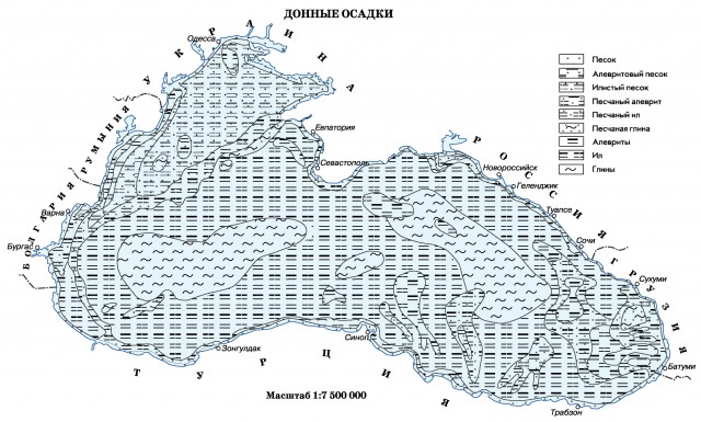
The coastal zone is dominated by coarse-grained bottom sediments: pebbles, gravel, sands; with distance from the coast, they are quickly replaced by fine-grained sands and silts. In the northwestern part, shell rocks and modern shell banks are widespread, inhabited by mussels, oysters and other molluscs. The slope and bottom of the depression are characterized by pelitic silts, the carbonate content of which increases towards the center of the sea (in some places it exceeds 50%); in the carbonate material, coccolithophorids play a significant role. In the southeastern part of the sea, at depths of up to 2000 m, there are deposits of silt and sand carried by turbidity flows.
In accordance with the nature of wind activity over the sea, strong waves most often develop in autumn and winter in the northwestern, northeastern and central parts seas. Depending on the wind speed and wave acceleration wavelength, waves 1–3 m high prevail in the sea. In open areas, the maximum wave heights reach 7 m, and in very strong storms it can be even higher. southern part the seas are the calmest, strong waves are rarely observed here, and there are almost no waves with a height of more than 3 m.
Seasonal changes in sea level are mainly due to intra-annual differences in river flow inflow. Therefore, in the warm season, the level is higher, in the cold season, it is lower. The magnitude of these fluctuations is not the same and is most significant in areas affected by continental runoff, where it reaches 30–40 cm.
The highest value in has a surge-surging level fluctuations associated with the impact of stable winds. They are especially often observed in the autumn-winter time in the western and north-western parts of the sea, where they can exceed 1 m. In the west, strong surges cause east and north-east winds, and in the north-west - southeast. Strong surges in the indicated parts of the sea occur with north-westerly winds. At the Crimean and Caucasian coasts, surges and surges rarely exceed 30–40 cm. Usually, their duration is 3–5 days, but sometimes it can be longer.
In the Black Sea, seiche level fluctuations up to 10 cm high are often observed. Seiches with periods of 2–6 hours are excited by the effect of the wind, and 12-hour seiches are associated with tides. The Black Sea is characterized by irregular semi-diurnal tides.
Ice formation usually begins in mid-December, and the maximum distribution of ice is observed in February. The duration of the ice period varies greatly: from 130 days in very severe winters, to 40 days in mild winters. The ice thickness does not exceed 15 cm on average; in severe winters it reaches 50 cm.
Ice forms annually only in a narrow coastal strip of the northwestern part of the sea. Even in severe winters, it covers less than 5%, and in moderate winters - 0.5–1.5% of the sea area. In very harsh winters, fast ice along west coast extends to Constanta, and floating ice is carried to the Bosphorus.
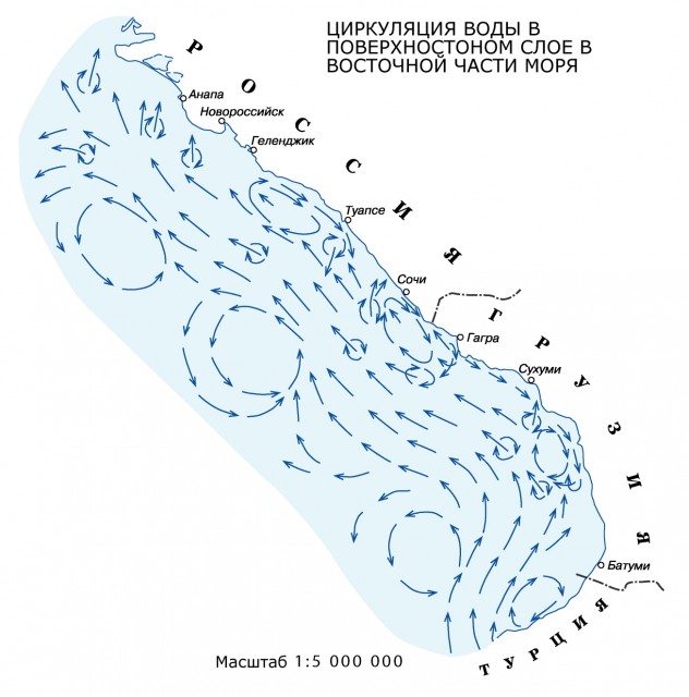
The circulation of water throughout the year has a cyclonic character with cyclonic gyres in the western and eastern parts the sea and the main Black Sea current bending around them along the coastal current.
The main Black Sea current and cyclonic gyres are most pronounced in winter and summer. In spring and autumn, water circulation becomes weaker and more complex in structure.
The general circulation of sea waters has a unidirectional character down to a depth of about 1000 m. In deeper layers it is very weak, and, in general, it is difficult to speak about its nature.
An important feature of the main Black Sea current is meandering, which can lead to the formation of isolated eddies that differ in salinity temperature from the surrounding waters. The size of the eddies reaches 40–90 km. The phenomenon of vortex formation is essential for water exchange not only in the upper, but also in the deep layers of the sea.
Inertial currents with a period of 17-18 hours are widespread in the open sea. These currents affect mixing in the water column, since their velocities even in a layer of 500–1000 m can be 20–30 cm / s.
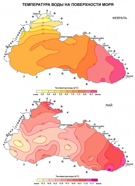
The water temperature on the sea surface in winter rises from –0.5 to 0 ° С in the coastal regions of the northwestern part to 7–8 ° in the central and 9–10 ° С in the southeastern part of the sea. In summer, the surface water layer warms up to 23–26 ° С. Only during surges can there be short-term significant drops in temperature (for example, in South Shore Crimea).
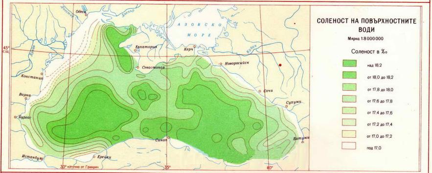
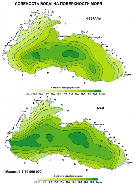
Salinity in the surface layer is minimal throughout the year in the northwestern part of the sea, which receives the bulk of river waters. In the estuarine areas, salinity increases from 0–2 to 5–10 ‰, and in most of the open sea water area it is 17.5–18.3 ‰. Deep waters in the layer from 1000 m to the bottom (more than 40% of the sea volume) are characterized by high constancy of temperature (8.5–9.2 ° С) and salinity (22–22.4 ‰).
In the cold season, vertical circulation develops in the sea, by the end of winter it covers a layer with a thickness of 30–50 m in the central regions to 100–150 m in the coastal regions. Waters are cooled the hardest in the northwestern part of the sea, from where they spread by currents to intermediate ones throughout the sea and can reach the regions farthest from cold centers. As a consequence of winter convection, with the subsequent summer warming up, a cold intermediate layer is formed in the sea. It persists throughout the year at horizons of 60–100 m and is distinguished by temperature at the boundaries of 8 ° С, and in the core –6.5–7.5 ° С.
Convective mixing in the Black Sea cannot spread deeper than 100–150 m due to an increase in salinity (and, consequently, density) in deeper layers as a result of the inflow of salty marble sea waters there. In the upper mixed layer, salinity increases slowly, and then sharply increases by 100–150 m from 18.5 to 21 ‰. This is a permanent salinity jump layer (halocline).
Starting from horizons of 150–200 m, salinity and temperature slowly rise to the bottom due to the influence of the saltier and warmer marble sea waters entering the deep layers. When leaving the Bosphorus, they have a salinity of 28–34 ‰ and a temperature of 13–15 ° C, but they rapidly change their characteristics, mixing with the Black Sea water. In the bottom layer, a slight increase in temperature also occurs due to the geothermal inflow of heat from the bottom of the sea.
Thus, the main components are distinguished in the vertical hydrological structure of the Black Sea waters:
- the upper homogeneous layer and the seasonal (summer) thermocline, associated mainly with the process of wind mixing and the annual cycle of heat flux through the sea surface;
- a cold intermediate layer with a minimum temperature in depth, which in the north-west and north-east of the sea arises as a result of autumn-winter convection, and in other regions is formed mainly by the transfer of cold waters by currents;
- permanent halocline - a layer of maximum salinity increase with depth, located in the contact zone of the upper (Black Sea) and deep (Marble Sea) water masses;
- deep layer - from 200 m to the bottom, where there are no seasonal changes in hydrological characteristics, and their spatial distribution is very homogeneous.
The processes occurring in these layers, their seasonal and interannual variability, determine the hydrological conditions of the Black Sea.
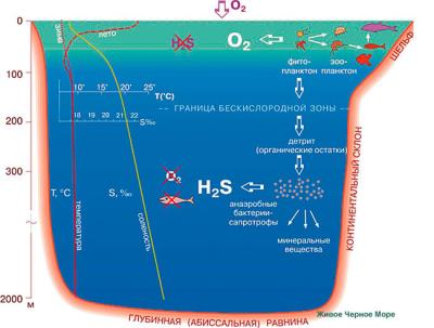
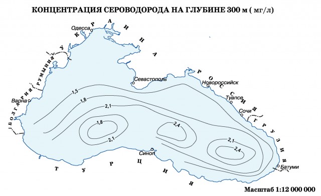
The Black Sea has a two-layer structure. Unlike other seas, only the upper, well-mixed layer (0–50 m) is saturated with oxygen (7–8 ml / L) in it. Deeper, the oxygen content begins to decrease rapidly, and already at horizons of 100–150 m, it is equal to zero. At the same horizons, hydrogen sulphide appears, the amount of which grows with depth to 5.3–6.6 ml / l at the 1500 m horizon, and further to the bottom it stabilizes. In the centers of the main cyclonic gyres, where the waters rise, the upper boundary of the hydrogen sulfide zone is located closer to the surface (70–100 m) than in the coastal areas (100–150 m).
On the border between the oxygen and hydrogen sulfide zones, there is an intermediate layer of the existence of oxygen and hydrogen sulfide, which is the lower “border of life” in the sea.
The diffusion of oxygen into the deep layers of the sea is hindered by large density gradients in the contact zone of the Black Sea and Marmara Sea waters. At the same time, water exchange in the Black Sea occurs throughout the entire water column, albeit slowly.
Diverse plant and animal world The Black Sea is almost entirely concentrated in the upper layer 150–200 m thick, which makes up 10–15% of the sea volume. The deep water column, deprived of oxygen and containing hydrogen sulfide, is almost lifeless and inhabited only by anaerobic bacteria.
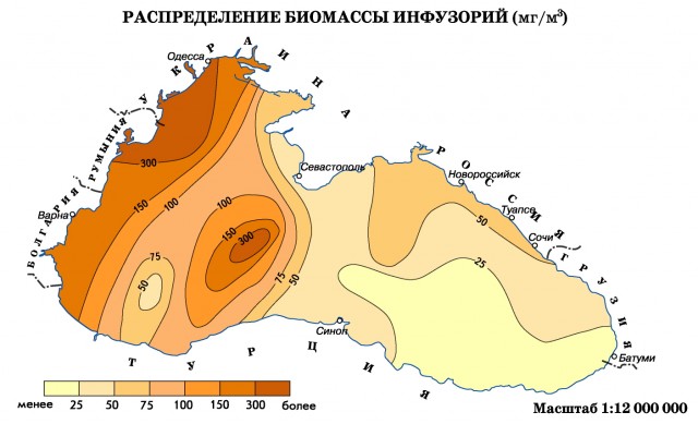
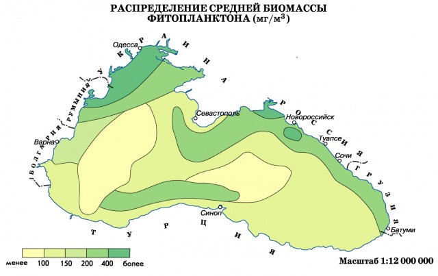
About 350 species of unicellular phytoplanktonic algae (including about 150 species of diatoms and peridiniaceae) and about 280 species of benthic macrophytes (129 red, 71 brown and 77 green algae and several types of seagrass - mainly zostera) are known from plants. Particularly abundant are the brown algae cystoseira and the red algae phyllophora, which forms huge accumulations at a depth of 20–50 m in the northwestern part of the sea (it is of commercial importance, the reserves are more than 5 million tons). The fauna of the Black Sea is about three times poorer than the Mediterranean.
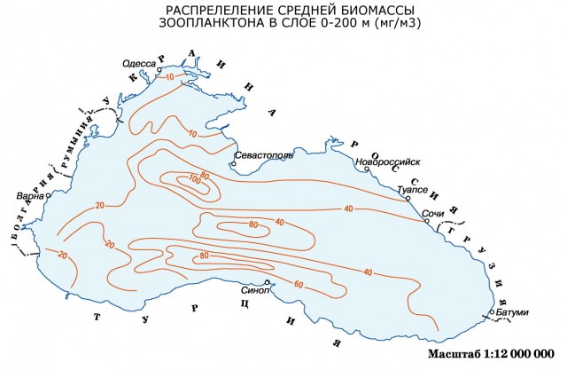
Among the animals, benthic species predominate (about 1700). The most characteristic biocenoses of mussel and phaseolin (after the mollusk Modiola phaseolina) silts: the first, mainly at a depth of 30-70 m, the second - 50-200 m. Mediterranean invaders prevail by origin (more than 30% of species); a lesser role is played by relics of the Pliocene brackish-water Pontic basin and freshwater invaders living in the most desalinated areas. About 12% are endemic species. A total of 2000 species are known: about 300 - protozoa, 650 different worms (including 190 polychaetes), 640 - crustaceans, more than 200 - molluscs, 160 - fish and about 150 - animals of other groups (including 4 species - mammals - seal and 3 species of dolphins). Due to the low salinity, many groups of stenohaline marine animals are few in number (for example, echinoderms of 14 species, radiolarians - 10 or absent (cephalopods, brachiopods, etc.).
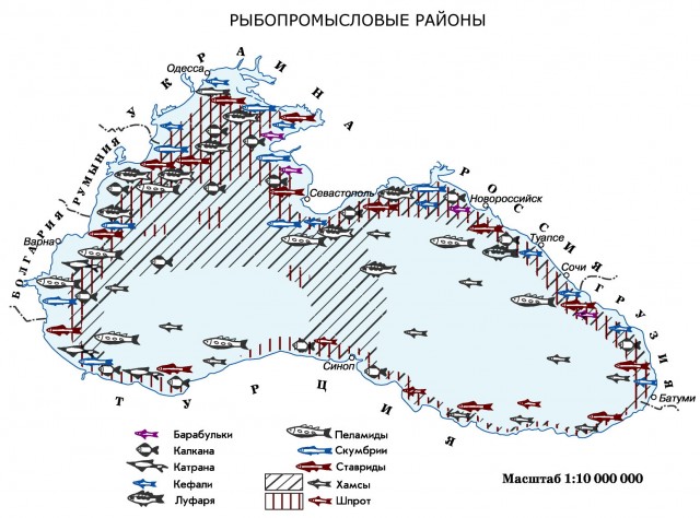
The ichthyofauna of the Black Sea was formed from representatives of different origins and has about 160 species of fish. One of the groups is fish of freshwater origin: bream, crucian carp, perch, rudd, pike perch, ram and others, found mainly in the northwestern part of the sea. In freshened areas and brackish-water estuaries, there are representatives of the ancient fauna that have survived since the existence of the ancient Ponto-Caspian basin. The most valuable of them are sturgeon, as well as several types of herring. The third group of Black Sea fish is made up of immigrants from the North Atlantic - cold-loving sprat, whiting, prickly katran shark, etc. The fourth, largest group of fish - Mediterranean invaders - has over a hundred species. Many of them enter the Black Sea only in summer, and winter in the Marmara and Mediterranean seas... Among them are bonito, mackerel, tuna, Atlantic horse mackerel, etc. Only 60 species of fish of Mediterranean origin that constantly live in the Black Sea can be considered Black Sea. These include: anchovy, garfish, mullet, horse mackerel, red mullet, mackerel, kalkan, stingrays, etc. Of the 20 commercial species of the Black Sea fish, only anchovy, small horse mackerel and sprat, as well as katran shark are important.

Currently, the state of the Black Sea ecosystem is unfavorable. There is a depletion of the species composition of plants and animals, a reduction in the stock of useful species. This is primarily observed in shelf areas experiencing significant anthropogenic pressure. The greatest changes are observed in the northwestern part of the sea. A large amount of biogenic and organic substances coming here from the continental runoff, causes the massive development of planktonic algae ("bloom"). In the areas affected by the Danube River runoff, the phytoplankton biomass increased by 10–20 times. When the supply of oxygen to the bottom layers of the sea water is limited, its deficiency develops - hypoxia, which can lead to the death of bottom organisms (deaths). Deterioration of water quality and oxygen regime is one of the main reasons for the decline in the number of commercial fish in the northwestern part of the Black Sea.
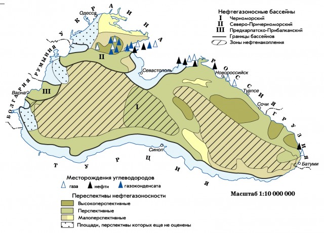
V Russian sector There are no explored oil and gas deposits in the Black Sea. There are only promising areas. On the shelf adjacent to the southern part Taman Peninsula, within the depths of the seabed of 100–200 m, local uplifts have been identified, which are the western continuation of the folds of the Kergen-Taman trough, to which oil and gas fields Krasnodar Territory.
On a small estuary - Lake Solenoe - located southeast of Cape Zhelezny Rog on the coast of the Taman Peninsula, a typical beach placer, composed of fine-grained sands with a heavy fraction (7.5-30%), in which the content of garnets reaches 68%, has been revealed.
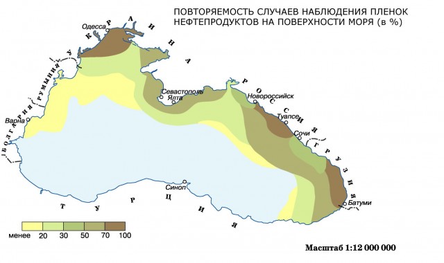
The protection of the Black Sea waters is of great importance. The sea is most polluted by oil and oil products, phenols and detergents. The western part of the sea is especially polluted with oil, where the routes of ships run along the lines Odessa – the mouth of the Danube – Istanbul and Odessa – the mouth of the Danube – Varna, as well as coastal waters. Work is underway to prevent the discharge of untreated industrial and domestic wastewater into the sea; the discharge of oil, oil products and other substances that pollute water is completely prohibited.
Site search: