These are the products of condensation of water vapor, falling from clouds in the form of rain, snow, grains, hail, or settling from the air on earth surface like dew, frost, frost. They are all called hydrometeors. The transition of water vapor to a liquid or solid state occurs when the air is saturated with vapors. In this case, an excess amount of water vapor is released in the form of water droplets or ice crystals. A necessary condition is the presence of condensation nuclei, the smallest grains of dust, each of which is covered with a film of water. This is how a droplet appears. In the absence of dust grains for air oversaturated with vapors, air molecules become condensation nuclei.
The smallest droplets of water (with a diameter of 0.05 to 0.1 mm) seem to float in the air. Each droplet of water or each ice crystal is supported by upward currents of air; because of this, the clouds are kept at a certain height. Colliding, the droplets in the cloud combine, their mass increases, and they fall to the ground - small droplets in the form of drizzle (up to 0.5 mm in diameter), and large ones rain down. The stronger the ascending air jets, the larger the falling drops should be. Therefore, in the summer, when the irisechmic air is heated and rapidly rises, large-droplet rains usually fall (the diameter of the drops is up to 6-7 mm), and in the spring and especially in the fall - drizzling.
Clouds are formed not only during convection of air, when their cumulus accumulations arise, but also in those cases when air currents with unequal temperatures move one above the other, for example, warm air over cold air or vice versa. With stirring air masses where the vapor is close to saturation, stratus clouds arise. According to their composition, clouds are subdivided into water, ice and mixed. The water droplets formed around the condensation nuclei in the cloud are often stored at temperatures below zero in a supercooled, but liquid state (even at a temperature of -20 ° C). Part of the droplets turns into snowflake ice crystals. From a water cloud it becomes mixed. Connecting with each other, the snowflakes fall in flakes of snow. Supercooled water droplets often turn into small icy spherical formations (sphero crystals) that fall out of the atmosphere in the form of cereals with a diameter of 1 to 15 mm.
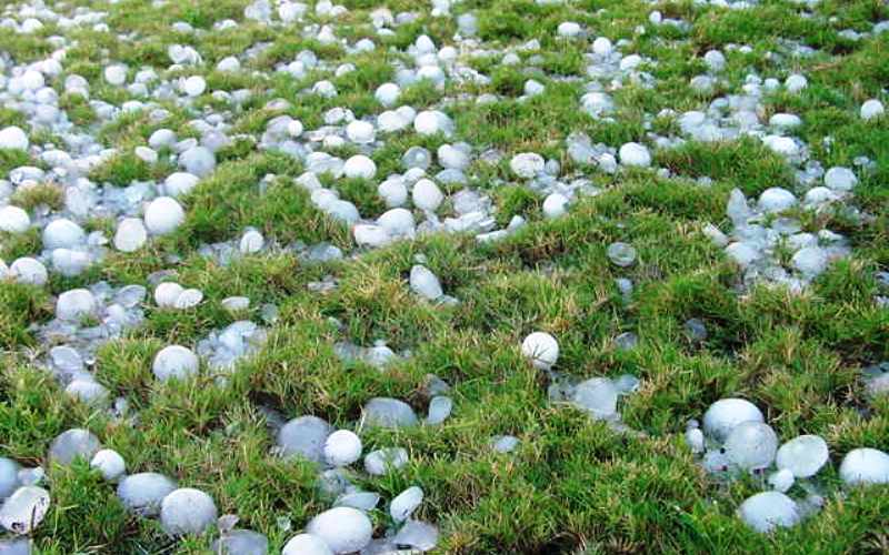
More difficult path education passes hail. Having broken the hailstone, one can easily make sure that it has a layered structure - in the center there is an ice sphere crystal in a thin shell of loose ice, then an ice shell, then loose again, etc. This indicates that after the formation of the central sphero crystal a, it repeatedly descended into cloud and rose by ascending vertical currents of air, taking on a layered structure and increasing in size. Hailstones are as large as a pigeon's egg, and sometimes more (hailstones of 1 and even 2 kg are known).
The shape of the clouds is varied and changeable. But they can still be grouped into several types. By the nature of the clouds, they judge what kind of precipitation (rain, hail) can fall, and even their amount. An international classification of clouds according to their appearance and height of their location has been developed.
There are three tiers of heights, for which certain types of clouds are most characteristic. The lower tier is from the surface of the Earth up to 2 km. For him, stratus clouds, stratocumulus, and nimbostratus are common. The middle tier is from 2 to 4 km in high latitudes of the globe, towards the equator it expands from 2 to 8 km. It is dominated by Altostratus and Altocumulus clouds. The upper tier is from 3 to 8 km in high latitudes, up to 13 km in middle latitudes, and from L to 18 km in low latitudes. It is characterized by cirrus, cirrocumulus, cirrostratus clouds.
Certain types of clouds from one tier penetrate into others, for example, altostratus - from the middle tier to the upper, stratocumulus - from the lower to the middle, and cumulus and cumulonimbus, often giving rain showers with thunderstorms, may have a base in the lower, and the top in the upper tier (their height reaches 9 km).
Three types of clouds are considered to be the main ones: cirrus, cumulus, stratus. The rest of the forms are their combinations.
The degree of coverage of the sky with clouds is called cloudiness, it is estimated on a 10-point scale or as a percentage. The height and speed of the clouds are measured with a special device - a nefoscope. Clouds can tell us about the upcoming weather. For example, if cirrus clouds appeared high in the sky, and then clouds began to cover the sky, then it is very likely that after a while it will rain. When high clouds first move, and they are replaced by lower and lower ones, it means that a front of warm air mass is approaching, on the border with which rains are common. There are other signs of an approaching bad weather: groups of clouds are increasing, thickening, falling; the clouds are moving rapidly, getting heavier and lower; isolated swirling clouds merge and descend; the bases of the clouds darken, become flat; bulky powerful clouds appear at high altitudes around noon.
Signs of good weather: morning fog clears before noon; the number of clouds gradually decreases, their bases rise higher and higher; a stratum of stratus clouds breaks through, revealing a clear, cloudless sky.
However, there are hardly any completely reliable weather forerunners: after all, they differ in different areas and are associated not only with the local situation, but also with influences from outside, from more or less remote areas.
The nature of atmospheric precipitation is very diverse and is determined by many conditions - the time of year and day, temperature in the lower layers of the troposphere, air movement (calm, light, strong wind etc.).
Rains are short-term and prolonged, drizzling and torrential, and precipitation in solid form - snowfalls, cereals, hail.
The amount of precipitation is measured by the rain gauge and is equal to the water layer in millimeters per certain time; solids are melted and also measured as a layer of water. From observations over many years, the average amount of precipitation for the year is calculated.
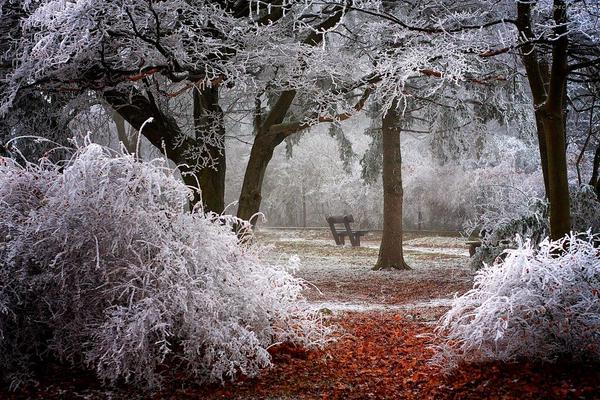
Ground precipitation, in contrast to precipitation from the free atmosphere, occurs in the form of dew, frost, hoar frost, ice in those cases when warmer humid air comes into contact with the surface of cooled objects and water condenses on them. Dew usually forms in clear weather after sunset with rapid cooling of blades of grass, leaves, thin branches, and grains of soil. Ground air, in contact with them, cools and reaches the dew point. The amount of dew depends on the degree of humidity and the cooling of objects. When the air temperature is below zero, not water droplets are formed on the surface of objects, but ice crystals-frost. Over time, it can build up, forming a layer of ice. On cold days with stable fogs, loose ice is deposited on objects; increasing due to small ice crystals floating in the air, it forms a beautiful fluffy coating - frost. Sometimes its mass is so great that under its weight tree branches break, telegraph and electric wires break.
During warming, a humid wind blowing cold objects causes the formation of water or ice deposits on them. This often happens in the mountains, where the ice crust reaches tens of centimeters. After severe frosts on the surface of the soil, roads, on the walls of houses, on the trees, a layer of transparent ice-ice, or aurora, forms. It also arises from rain, the drops of which freeze in a layer of cold surface air. Surface precipitation accounts for a small fraction of all precipitation.
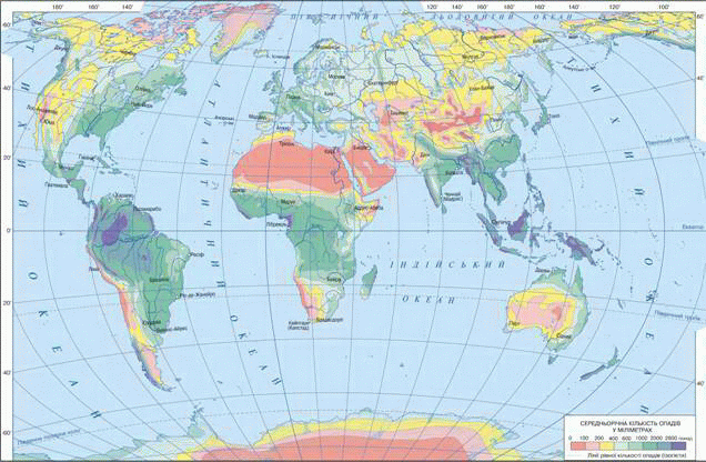
The distribution of precipitation over the Earth's surface is uneven and is determined by many conditions. The bulk of water vapor enters the atmosphere from the World Ocean. He also receives the bulk of the precipitation. Most precipitation in equatorial zone- from 1500 to 2000 mm per year, the smallest - in the high latitudes of the Arctic and Antarctic - 200-300 mm. Little precipitation falls in the zone of high atmospheric pressure (20-40 °). In belts temperate latitudes precipitation is higher than near the tropics and in the polar regions, up to 600-1000 mm. A great influence on the amount of precipitation on land is exerted by its proximity to the seas and sea currents: warm ones increase them, cold ones decrease them. An important factor- air currents. For example, the west of Eurasia (up to the Urals), where air transport from the Atlantic dominates, is more humid than Siberia and middle Asia... The relief plays an important role. On the slopes mountain ranges facing humid winds from the ocean, moisture falls noticeably more than on opposite ones - this is clearly seen in the Cordilleras of America, on the southern spurs of the Himalayas (here the Cherrapunji region is the rainyest - up to 12 thousand mm per year), on the eastern slopes of the mountains Of the Far East and so on. On maps, points with the same amount of precipitation are connected by lines - and zogiyets.
In some places, there is a lot of precipitation, and little moisture evaporates - excessive moisture; in other places, precipitation is low, and evaporation is high (for example, in deserts). The moisture coefficient shows the ratio of the amount of precipitation to the amount that can evaporate from a given area over a certain period (for example, a year): K = (R / E) x100%, where R is precipitation, E is the amount of evaporation. Thus, K shows how much precipitation in this place compensate for possible evaporation from an open water surface. The value of this coefficient in the forest zone is 1.0-1.5, in the forest-steppe - 0.6-1.0, in the steppe - 0.8-0.6, in the semi-desert - 0.1 - 0.3, in the desert - less than 0.1. In other words, more precipitation falls in the forest zone than can evaporate - excessive moisture, in the steppes K less than unity - insufficient moisture; in deserts, precipitation is a small fraction of evaporation, moisture is negligible.
Send your good work in the knowledge base is simple. Use the form below
Students, graduate students, young scientists who use the knowledge base in their studies and work will be very grateful to you.
Posted on http://www.allbest.ru/
Recently, in different parts of the world, more and more problems have arisen related to the amount and nature of precipitation. This year, Ukraine experienced a very snowy winter, but at the same time, Australia experienced an unprecedented drought. How does precipitation occur? What determines the nature of the loss and many other issues are relevant and important today. Therefore, I chose the theme of my work "Education and types of precipitation."
Thus, the main goal of this work is to study the formation and types of precipitation.
In the course of work, the following tasks are distinguished:
Definition of the concept of atmospheric precipitation
· Study existing species atmospheric precipitation
· Addressing the problem and consequences of acid rain.
The main research method in this work is the method of research and analysis of literary sources.
Precipitation(Greek atmos - steam and Russian precipitate - fall to the ground) - water in liquid (drizzle, rain) and solid (cereal, snow, hail), falling out of the clouds as a result of condensation of vapors rising mainly from oceans and seas (evaporated water from land makes up about 10% of atmospheric precipitation). Precipitation also includes frost, frost, dew, which are deposited on the surface of terrestrial objects during condensation of vapors in air saturated with moisture. Atmospheric precipitation is a link in the general moisture turnover of the Earth. With the onset of a warm front, heavy and drizzling rains are common, and with a cold front, torrential rains. Precipitation is measured using a precipitation gauge at meteorological stations with the thickness of the water layer (in mm), which has dropped out per day, month, year. The average amount of atmospheric precipitation on the Earth is about 1000 mm / year, but in deserts less than 100 and even 50 mm / year falls, and in the equatorial zone and on some windward slopes of the mountains - up to 12000 mm / year (Charranuja meteorological station at an altitude of 1300 m). Atmospheric precipitation is the main supplier of water to watercourses that feed the entire organic world to soils.
The main condition for the formation of atmospheric precipitation is the cooling of warm air, leading to the condensation of the vapor contained in it.
When warm air rises and cools, clouds of water droplets are formed. Colliding in a cloud, drops combine, their mass increases. The bottom of the cloud turns blue and it rains. At negative air temperatures, water droplets in the clouds freeze and turn into snowflakes. Snowflakes stick together into flakes and fall to the ground. During a snowfall, they can melt a little, and then it snows. It happens that air currents repeatedly lower and raise frozen drops, at this time ice layers build up on them. Finally, the droplets become so heavy that they fall to the ground in hail. Sometimes hailstones reach the size of a hen's egg. V summer time in clear weather, the earth's surface cools. From it the surface layers of air are cooled. Water vapor begins to condense on cold objects - leaves, grass, stones. This is how dew is formed. If the surface temperature was negative, then the water droplets freeze, forming frost. Dew usually falls in summer, frost in spring and autumn. At the same time, both dew and frost can form only in clear weather. If the sky is covered with clouds, then the earth's surface cools slightly and cannot cool the air.
According to the method of formation, convective, frontal and orographic sediments are distinguished. The general condition for the formation of precipitation is the upward movement of air and its cooling. In the first case, the reason for the rise of air is its heating from a warm surface (convection). Such precipitation falls all year round in the hot zone and in the summer in temperate latitudes. If warm air rises when interacting with colder air, then frontal precipitation is formed. They are more characteristic of temperate and cold zones, where warm and cold air masses are more common. The reason for the rise of warm air can be its collision with mountains. In this case, orographic sediments are formed. They are characteristic of the windward slopes of the mountains, and the amount of precipitation on the slopes is greater than in the adjacent areas of the plains.
The amount of precipitation is measured in millimeters. On average, about 1100 mm of precipitation falls on the earth's surface per year.
Precipitation falling from clouds: rain, drizzle, hail, snow, groats.
Distinguish:
· Heavy precipitation associated mainly with warm fronts;
· Heavy rainfall associated with cold fronts. Precipitation from the air: dew, frost, frost, ice. Precipitation is measured by the thickness of the precipitated water layer in millimeters. On average the globe about 1000 mm of precipitation falls per year, and in deserts and in high latitudes - less than 250 mm per year.
Measurement of precipitation is carried out by rain gauges, rain gauges, pluviographs at meteorological stations, and for large areas - using radar.
Long-term, average monthly, seasonal, annual precipitation, their distribution over the earth's surface, annual and daily variation, frequency, intensity are the defining characteristics of the climate that are essential for agriculture and many other sectors of the national economy.
The greatest amount of precipitation on the globe should be expected where the atmospheric humidity is high and where there are conditions for the rise and cooling of the air. The amount of precipitation depends: 1) on latitude, 2) on the general circulation of the atmosphere and related processes, 3) on the relief.
The greatest amount of precipitation both on land and at sea falls near the equator, in the belt between 10 ° N. NS. and 10 ° S. NS. Further to the north and south, the amount of precipitation decreases in the area of the trade winds, and the minimum precipitation more or less coincides with the subtropical pressure maximum. At sea, precipitation minimums are located closer to the equator than on land. However, the figures illustrating the amount of precipitation at sea cannot be particularly trusted due to the small number of observations.
From subtropical pressure maxima and precipitation minima, the amount of these latter increases again and reaches a second maximum at approximately 40-50 ° latitudes, and from here decreases to the poles.
The large amount of precipitation under the equator is explained by the fact that here, due to thermal reasons, an area of low pressure with upward currents is created, air with a high content of water vapor (on average e = 25mm), rising, cools and condenses moisture. Low rainfall in the trade wind area is due to these last winds.
The smallest amount of precipitation observed in the area of subtropical pressure maxima is explained by the fact that these areas are characterized by downward air movement. As the air sinks, it heats up and becomes dry. Further to the north and south, we enter the region of the prevailing south-western and north-western winds, i.e. winds moving from more warm countries to colder ones. Here, in addition, cyclones very often occur, therefore, conditions are created that are favorable for the rise of air and its cooling. All this entails an increase in the amount of precipitation.
As for the decrease in the amount of precipitation in the polar region, it must be borne in mind that they refer only to the measured precipitation - rain, snow, croup, but the deposition of frost is not taken into account; meanwhile, it must be assumed that the formation of frost in polar countries, where the relative humidity is very high due to low temperatures, occurs in large quantities. Indeed, some polar travelers observed that condensation occurs here mainly from the lower layers of air in contact with the surface in the form of frost or ice needles that settle on the surface of snow and ice and noticeably increase their thickness.
The relief has a tremendous effect on the amount of moisture deposited. Mountains, forcing the air to rise, cause its cooling and vapor condensation.
It is especially clear to trace the dependence of the amount of precipitation on the height in such settlements, which are located on the slopes of the mountains, and their lower quarters are at sea level, and the upper ones are located quite high. Indeed, in each locality, depending on the entire set of meteorological conditions, there is a certain zone, or height, at which the maximum condensation of vapors occurs, and above this zone the air becomes drier. So, on Mont Blanc, the zone of greatest condensation lies at an altitude of 2600 m, in the Himalayas on the southern slope - on average at an altitude of 2400 m, in the Pamirs and Tibet - at an altitude of 4500 m. Even in the Sahara, the mountains condense moisture.
According to the time of maximum precipitation, all countries can be divided into two categories: 1) countries with predominant summer precipitation and 2) countries with predominant winter precipitation. The first category includes the tropical region, the more continental temperate regions and the northern land margins of the northern hemisphere. Winter precipitation prevails in subtropical countries, then in the oceans and seas, as well as in countries with maritime climate in temperate latitudes. In winter, the oceans and seas are warmer than land, the pressure decreases, and favorable conditions are created for the occurrence of cyclones and increased precipitation. We can establish the following subdivisions on the globe based on the distribution of precipitation.
Types of precipitation. Hail - a special kind of ice formations are called, sometimes falling out of the atmosphere and attributed to precipitation, otherwise hydrometeors. The type, structure and size of the hailstones are extremely diverse. One of the most common shapes is conical or pyramidal with sharp or slightly truncated tops and a rounded base. The upper part of these is usually softer, dull, as if snowy; middle - translucent, consisting of concentric, alternating transparent and opaque layers; the bottom, the widest, is transparent.
No less common is a spherical shape, consisting of an inner snow core (sometimes, although less often, central part consists of transparent ice) surrounded by one or more transparent shells. The hail phenomenon is accompanied by a special characteristic noise from the stress of hailstones, reminiscent of the noise emanating from the raining of nuts. Most of the hail falls in the summer and during the day. Hail at night is a rare occurrence. Lasts several minutes, usually less than a quarter of an hour; but there are times when it lasts longer. The distribution of hail on the ground depends on latitude, but mainly on local conditions. In tropical countries, hail is a very rare phenomenon, and it falls there almost only on high plateaus and mountains.
Rain - liquid precipitation in the form of drops with a diameter of 0.5 to 5 mm. Individual raindrops leave a trail on the surface of the water in the form of a diverging circle, and on the surface of dry objects - in the form of a wet spot.
Supercooled rain - liquid precipitation in the form of drops with a diameter of 0.5 to 5 mm, falling out at negative air temperatures (most often 0 ... -10 °, sometimes up to -15 °) - falling on objects, the drops freeze and ice forms. Freezing rain occurs when falling snowflakes are caught in a layer of warm air deep enough for the snowflakes to completely melt and turn into raindrops. As these droplets continue to fall, they pass a thin layer of cold air above the earth's surface and their temperature drops below freezing. However, the droplets themselves do not freeze, so this phenomenon has been called hypothermia (or the formation of "supercooled droplets").
Freezing rain - solid precipitation that falls at negative air temperatures (most often 0 ... -10 °, sometimes up to -15 °) in the form of solid transparent ice balls with a diameter of 1-3 mm. Formed when rain drops freeze when they fall through the lower layer of air with negative temperatures. There is unfrozen water inside the balls - falling on objects, the balls break into shells, water flows out and ice forms. Snow is solid precipitation that falls (most often at negative air temperatures) in the form of snow crystals (snowflakes) or flakes. In light snow, horizontal visibility (if there are no other phenomena - haze, fog, etc.) is 4-10 km, with moderate 1-3 km, with heavy snow - less than 1000 m (while the snowfall increases gradually, so visibility values of 1-2 km or less are observed no earlier than an hour after the beginning of the snowfall). In frosty weather (the air temperature is below -10 ... -15 °), light snow can fall from the cloudy sky. The phenomenon of wet snow is noted separately - mixed precipitation falling during positive temperature air in the form of flakes of melting snow. Rain and snow - mixed precipitation that falls (most often at a positive air temperature) in the form of a mixture of drops and snowflakes. If rain and snow falls at a negative air temperature, precipitation particles freeze onto objects and ice forms.
Drizzle - liquid precipitation in the form of very small droplets (less than 0.5 mm in diameter), as if floating in the air. The dry surface gets wet slowly and evenly. When settling on the surface of the water, it does not form diverging circles on it.
Fog is an accumulation of condensation products (drops or crystals, or both) suspended in the air, directly above the earth's surface. Clouding of the air caused by this accumulation. Usually these two meanings of the word fog do not differ. In fog, horizontal visibility is less than 1 km. Otherwise, the haze is called haze.
Downpour - short-term atmospheric precipitation, usually in the form of rain (sometimes - wet snow, cereals), characterized by high intensity (up to 100 mm / h). They arise in unstable air masses on a cold front or as a result of convection. Usually heavy rain covers a relatively small area. Heavy snow - heavy snow. It is characterized by sharp fluctuations in horizontal visibility from 6-10 km to 2-4 km (and sometimes up to 500-1000 m, in some cases even 100-200 m) for a period of time from several minutes to half an hour (snow "charges") ... Snow grains - solid rainfall precipitation, falling at an air temperature of about zero ° and having the appearance of opaque white grains with a diameter of 2-5 mm; grains are fragile, easily crushed by fingers. Often falls before or simultaneously with heavy snow. Ice grains - solid rainfall precipitation, falling at an air temperature of +5 to + 10 ° in the form of transparent (or translucent) ice grains with a diameter of 1-3 mm; in the center of the grains there is an opaque core. The grains are quite hard (they are crushed by fingers with some effort), when they fall on a hard surface, they bounce off. In some cases, grains can be covered with a water film (or fall out together with water droplets), and if the air temperature is below zero °, then falling on objects, the grains freeze and ice forms.
Dew (Latin ros - moisture, liquid) - atmospheric precipitation in the form of water droplets deposited on the surface of the earth and ground objects when the air is cooled.
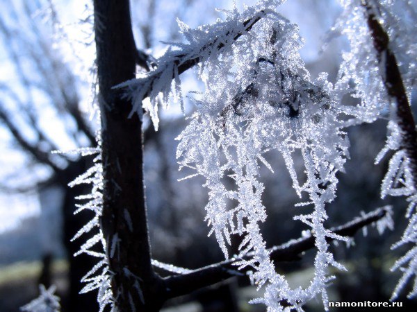
Rime - loose ice crystals that grow on tree branches, wires and other objects, usually when drops of supercooled fog freeze. Formed in winter, more often in calm frosty weather as a result of sublimation of water vapor when the air temperature drops.
Hoarfrost is a thin layer of ice crystals that form on cold, clear and quiet nights on the surface of the earth, grasses and objects with negative temperatures, and lower than the air temperature. Frost crystals, like frost crystals, are formed by sublimation of water vapor.
For the first time, acid rain was observed in Western Europe, in particular Scandinavia, and North America in the 1950s. Now this problem exists throughout the industrial world and has acquired particular importance in connection with the increased man-made emissions of sulfur and nitrogen oxides. precipitation acid rain
When power plants and industrial enterprises coal and oil are burned, huge amounts of sulfur dioxide, suspended particles and nitrogen oxides are emitted from their chimneys. In the United States, power plants and factories account for 90 to 95% of sulfur dioxide emissions. and 57% of nitrogen oxides, with almost 60% of sulfur dioxide emitted by tall pipes, making them easier to transport over long distances.
As discharges of sulfur dioxide and nitrogen oxide from stationary sources are carried over long distances by the wind, they generate secondary pollutants such as nitrogen dioxide, nitric acid vapor and droplets containing solutions of sulfuric acid, sulfate and nitrate salts. These chemical substances fall on the earth's surface in the form of acid rain or snow, and also in the form of gases, shroud, dew or solid particles. These gases can be directly absorbed by the foliage. The combination of dry and wet precipitation and the absorption of acids and acid-forming substances from near or on the earth's surface is called acid precipitation, or acid rain. Another cause of acid precipitation is the release of nitric oxide to large numbers of vehicles in large cities... This type of pollution is dangerous for both urban and rural areas. After all, water droplets and most of the particulate matter are quickly removed from the atmosphere, acid precipitation is more of a regional or continental than a global problem.
Consequences of acid rain:
· Damage to statues, buildings, metals and car finishes.
· Loss of fish, aquatic plants and microorganisms in lakes and rivers.
Weakening or loss of trees, especially conifers, which grow at high altitudes, due to the leaching of calcium, sodium and other nutrients from the soil Damage to the roots of trees and the loss of numerous fish species due to the release of aluminum ions from the soil and sediments, lead, mercury and cadmium
· Weakening trees and increasing their tendency to disease, insects, droughts, fungi and mosses that bloom in acidic environments.
· Slow down the growth of crops such as tomatoes, soybeans, beans, tobacco, spinach, carrots, broccoli and cotton.
Acid precipitation is already a serious problem in Northern and Central Europe, in the northeastern United States, southeastern Canada, parts of China, Brazil and Nigeria. They are beginning to pose an increasing threat in the industrial regions of Asia, Latin America and Africa and in some places in the western United States (mainly due to dry precipitation). Acid precipitation also falls in the ranks of tropical regions, where the industry is practically not developed, mainly due to the release of nitrogen oxides during the combustion of biomass. Most of the acidifying substances produced water country, carried by the prevailing surface winds to the territory of another. More than three quarters of acid precipitation in Norway, Switzerland, Austria, Sweden, the Netherlands and Finland is brought to these countries by the wind from industrial areas Western and Eastern Europe.
List of used literature
1. Akimova, T. A., Kuzmin A. P., Khaskin V. V., Ecology. Nature - Man - Technology: Textbook for universities. - M .: UNITI - DANA, 2001. - 343s.
2. Vronsky, V. A. Acid rain: an ecological aspect // Biology in school.- 2006.- №3.- p. 3-6
3. Isaev, AA Ecological climatology. - 2nd ed. rev. and additional - M .: Scientific world, 2003.- 470s.
5. Nikolaykin, N.I., Nikolaykina N.E., Melekhova O. P. Ecology.- 3rd ed. revised and additional - M .: Bustard, 2004. - 624s.
6. Novikov, Yu. V. Ecology, environment, man: textbook.- M .: Grand: Fair - press, 2000.- 316s.
Posted on Allbest.ru
...Similar documents
Types of precipitation as products of condensation, sublimation of water vapor in the atmosphere, their classification. Precipitation falling on the earth's surface. Chemical composition of atmospheric precipitation, patterns of their distribution. Daily and annual precipitation.
term paper added 06/03/2014
The main types of precipitation and their characteristics. Types of daily and annual precipitation. Geographic distribution of precipitation. Indicators of snow cover on the Earth's surface. Atmospheric humidification as a degree of supplying the area with moisture.
presentation added on 05/28/2015
Climate-forming factors Overseas Europe... Distribution of precipitation by seasons. Climatic zones... Monthly data on thermal conditions and dynamics of precipitation. The influence of radiation conditions, as well as the effect of the general circulation of the atmosphere.
term paper added 04/21/2014
The process of formation of sedimentary rocks in the oceans. The role of climate, relief, marine animals and plant organisms in the formation of precipitation. The nature of the life of organisms and their distribution in the waters of the World Ocean. Development of the Earth's biosphere.
test, added 02/07/2011
Modern natural conditions on the earth's surface, their evolution and patterns of change. The main reason for the zoning of nature. Physical properties of the water surface. Sources of atmospheric precipitation on land. Latitudinal geographic zoning.
abstract, added 06/04/2010
Physical and geographical description of meteorological stations. Features of the distribution of precipitation in spring on the territory of the Western and East Kazakhstan... Their climatic features, classification, statistical characteristics, dynamics of the time course.
term paper, added 12/16/2014
Physical and geographical description of the meteorological station Uralsk and Atyrau, Semey and Urdzhar, their comparative characteristics, equipment used and performance evaluation. Precipitation mode: monthly and annual amount, average and maximum daily.
term paper, added 04/25/2014
The essence of paleogeography as a science, the subject and methods of its study, the history of origin and development. The main directions of this science. Methods for restoring the conditions of precipitation accumulation. Diagnostic signs of fossil facies, their specific features.
abstract, added 04/23/2010
Physical and geographical position and landforms of Eurasia. Distribution in the territory of all major natural areas Earth. Inland waters and climatic conditions... Uneven precipitation. Features of the animal and flora Eurasia.
term paper added 03/21/2015
The water cycle in nature. Geographic distribution of precipitation. Time cycles of water availability. Major underground and surface sources... Water consumption, its quality. Water use in agriculture. Water scarcity and overcoming it.
The air of the atmosphere cannot contain an infinitely large amount, and clouds cannot contain water droplets and ice crystals. Excess moisture falls on the earth's surface in the form.
Precipitation formation
Atmospheric precipitation is water that has fallen to the ground from clouds (rain, snow, hail) or directly from the air (dew, frost,). Why does precipitation fall? Clouds are made up of tiny water droplets and ice crystals. They are so small (1 cubic centimeter contains up to 600 drops) that they are held by air currents and do not fall to the ground. But droplets and snowflakes can merge with each other. Then they increase in size, become heavy and fall to the ground in the form of precipitation.
In the warm season, precipitation from the clouds falls in liquid form (rain, drizzle), in the cold season - in solid form (snow, cereal). However, sometimes in summer, solid precipitation- hail. These are grains of ice up to several centimeters in diameter.
For the formation of precipitation, the air must necessarily rise up. The rise of air is possible when it is strongly heated from the earth's surface, such as at the equator. But this also happens when warm air collides with mountains or with heavier cold air. At the same time, light warm air rises along the slopes of mountains or over the surface of cold air. In any case, warm air cools down as it rises, clouds form from water vapor and precipitation falls.
Distribution of atmospheric precipitation
Precipitation is unevenly distributed over the earth's surface. Most of them fall in equatorial latitudes... In the direction from the equator to the tropics, the amount of precipitation decreases. In temperate latitudes, it increases again, and decreases in polar ones.
On maps, points with the same amount of precipitation are connected by isolines - isohytes. The space between them is painted over using increasing color saturation.
Introduction
The relevance of the study of atmospheric precipitation lies in the fact that - the main water-balance component of all types of natural waters and the main source natural resources groundwater is precipitation. Atmospheric fallout constantly affects all components environment, represent an unavoidable factor and therefore, in the theory of risk, they belong to the highest category.
Atmospheric precipitation as products of condensation and sublimation of water vapor in the atmosphere is an important climatic parameter that determines the mode of humidification of the territory. For the occurrence of atmospheric precipitation, it is necessary to have a moist air mass, ascending movements and condensation nuclei.
Therefore, by the amount and intensity of precipitation it is possible to indirectly judge the nature of vertical movements in the atmosphere, which are most difficult to assess in the energy cycle of the atmosphere.
The aim of the work is to study atmospheric precipitation and their chemical composition.
To achieve this goal, it is necessary to solve the following tasks:
1. Consider the concept of atmospheric precipitation;
2. Explain the distribution of daily and annual precipitation;
3. Consider the classification of atmospheric precipitation;
4. Find out what chemical components are in the composition of precipitation
Work structure. The course work consists of an introduction, six chapters, a conclusion, a bibliography and an application.
atmospheric precipitation chemical composition
> Precipitation and its types
Precipitation refers to moisture that has fallen to the surface from the atmosphere in the form of rain, drizzle, cereal, snow, hail. Precipitation falls from clouds, but not every cloud gives precipitation. The formation of precipitation from the cloud is due to the enlargement of the droplets to a size that can overcome the ascending currents and air resistance. The enlargement of droplets occurs due to the merging of droplets, evaporation of moisture from the surface of droplets (crystals) and condensation of water vapor on others. Precipitation is one of the links in the moisture cycle on Earth.
The main condition for the formation of atmospheric precipitation is the cooling of warm air, leading to the condensation of the vapor contained in it.
> Types of precipitation
Overburden precipitation - uniform, long-lasting, falling from stratus clouds;
Heavy rainfall - characterized by a rapid change in intensity and short duration. They fall from cumulonimbus clouds as rain, often with hail.
Drizzle - in the form of drizzle falls from stratus and stratocumulus clouds.
By origin, they are distinguished:
Convective precipitation is typical for the hot zone, where heating and evaporation are intense, but in summer they often occur in the temperate zone.
Frontal precipitation is formed when two air masses with different temperatures and other physical properties meet, fall out of the warmer air, forming cyclonic vortices, are typical for temperate and cold belts.
Orographic precipitation falls on the windward slopes of mountains, especially high ones. They are plentiful if the air comes from the side warm sea and has a high absolute and relative humidity. (see appendix 4)
Precipitation - water in a liquid or solid state, falling out of clouds or from the air onto the earth's surface and any objects.
Precipitation is measured by the thickness of the precipitated water layer in millimeters. On average, about 1000 mm of precipitation falls on the globe per year, and in deserts and in high latitudes - less than 250 mm per year.
At meteorological stations, precipitation is measured rain gauges.
Precipitation formation.
If the cloud is made up of very small water droplets or ice crystals (less than 0.05 mm), then there will be no precipitation. While they are small and light, they are kept high above the ground by updrafts. Under certain conditions, the droplets collide and coalesce into larger droplets. The clouds darken, turn blue-black. Large drops (0.1-7 mm) can no longer stay in the air and fall, forming rain.Snow is formed in the clouds, which at temperatures below 0 0 C consist of the smallest crystals-needles, connected in snowflakes.

Hail formed when warm air rises rapidly. It picks up rain clouds and carries them to a height where temperatures drop to -10 0 C. At the same time, the drops freeze and turn into ice balls - hailstones. They range in size from 1 mm to the size of a chicken egg. A hailstone weighing 7 kg, which fell during a hail in China (1981), and in Ukraine - 500 g, was the record-breaking largest in the world. (1960).
Precipitation can also "fall" out of thin air. This happens on the cooled surface of the earth when it comes into contact with air saturated with moisture.
Dew - drops of water that sometimes cover the ground and plants. It forms after sunset, when the surface of the earth and its air quickly cool. Cold air can no longer contain as much water vapor as it did during the day with more high temperature... Its excess condenses into dew droplets.

In the cold season (at temperatures below 0 0 С), instead of dew, a thin layer of ice crystals forms - frost. It can be seen in autumn or early spring.
Rime puffy ice crystals build up on tree branches and other objects.
Fog- atmospheric phenomenon, accumulation of water in the air, when the smallest condensation products of water vapor are formed (at air temperatures above -10 ° these are the smallest droplets of water, at -10 ... -15 ° - a mixture of water droplets and ice crystals, at temperatures below -15 ° - ice crystals sparkling in the sun's rays or in the light of the moon and lanterns).
Relative humidity in fog is usually close to 100%

![]()
Distribution of precipitation on the globe.
Precipitation on the planet is unevenly distributed. It depends on the geographic location terrain and prevailing winds. The greatest amount of precipitation falls in equatorial (over 2000 mm) and temperate (over 800 mm) latitudes. Little precipitation (200 mm) falls in tropical and polar latitudes... However, this distribution is violated by the nature of the earth's surface: more precipitation falls over the oceans than over land. In the mountains, much more rainfall "takes" those slopes turning to the prevailing winds. So, in Ukraine, the windward slopes of the Carpathians receive 1500 mm per year, and the leeward slopes - half as much - 750 mm per year.
The record high annual precipitation on Earth is the village of Cherrapunji, at the foot of the Himalayas - 23,000 mm. Record dry places with no rainfall for years are Atacama Desert v South America(1 mm per year) and Sahara in Africa (5 mm per year).
Annual change in precipitation , i.e. change in their number by months, in different places The earth is not the same. It is possible to outline several basic types of annual precipitation and express them in the form of bar graphs.
- Equatorial type - precipitation falls fairly evenly throughout the year, there are no dry months, only after the equinox days there are two small maxima - in April and October - and after the solstice days there are two small minimums - in July and January.
- Monsoon type - maximum precipitation in summer, minimum in winter. Inherent in subequatorial latitudes, as well as east coasts continents in subtropical and temperate latitudes. At the same time, the total amount of precipitation gradually decreases from the subequatorial to the temperate zone.
- Mediterranean type - maximum precipitation in winter, minimum - in summer. Observed in subtropical latitudes at west coasts and inside the continents. Annual quantity precipitation gradually decreases towards the center of the continents.
- Continental type precipitation in temperate latitudes - in the warm period, precipitation is two to three times more than in the cold one. As the continentality of the climate in the central regions of the continents increases, the total amount of precipitation decreases, and the difference between summer and winter precipitation increases.
- Marine type of temperate latitudes - precipitation is distributed evenly throughout the year with a small maximum in autumn and winter. Their number is greater than that observed for this type.
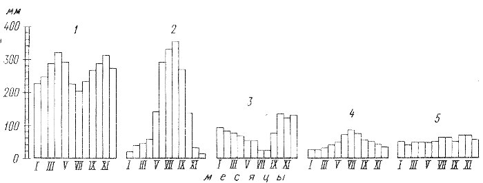
Types of annual precipitation:
1 - equatorial, 2 - monsoon, 3 - Mediterranean, 4 - continental temperate latitudes, 5 - marine temperate latitudes.
Questions and tasks
1. Name the precipitation falling on the earth's surface from clouds in liquid and solid form.
2. What harm can hail do?
3. How does frost dew form?
4. How is the amount of precipitation measured?
5. Think about why the World Ocean is called the main "supplier" of precipitation, and the Sun is the main "engine" of this process.