The natural complexes of the Earth are very diverse. It's hot and icy deserts, evergreen forests, endless steppes, bizarre mountains, etc. This diversity is the unique beauty of our planet. How were natural complexes"Mainland" and "ocean", you already know. But the nature of every continent, like every ocean, is not the same. There are various natural zones on their territories.
The natural zone is a large natural complex that has a common temperature and moisture conditions, soils, vegetation and fauna. The formation of zones is determined by the climate, on land - by the ratio of heat and moisture. So, if there is a lot of heat and moisture, i.e. high temperatures and a lot of precipitation, a zone is formed equatorial forests... If the temperatures are high and there is little precipitation, then a tropical desert zone is formed.
Natural areas sushi outwardly differ from each other in the nature of the vegetation. The vegetation of the zones of all the components of nature most clearly expresses all essential features their nature, the relationship between the components. If there are changes in individual components, then outwardly this affects primarily the change in vegetation. The names of the natural land areas were given by the nature of the vegetation, for example, the zones of deserts, equatorial forests, etc.
Rice. 33. Natural belts of the World Ocean
There are also natural zones in the oceans ( natural belts). They differ in water masses, the organic world, etc. The natural zones of the ocean do not have clear external differences, with the exception of the ice cover, and are named after them. geographic location as well as climatic zones (Fig. 33).
Regularities in the placement of natural zones on Earth. In the placement of natural areas on the earth's surface scientists have found a clear pattern that can be clearly traced on the map of natural zones. To understand this pattern, let us trace the change of natural zones from north to south on the map at 20 ° E. d. in subarctic belt where temperatures are low, there is a zone of tundra and forest-tundra, giving way to taiga to the south. There is enough warmth and moisture for conifers to grow. In the southern half temperate zone the amount of heat and precipitation increases significantly, which contributes to the formation of a zone of mixed and deciduous forests. To the east, the amount of precipitation decreases, so the steppe zone is located here.
On the coast Mediterranean Sea Europe and Africa have a Mediterranean climate with dry summers. It favors the formation of a zone of hard-leaved evergreen forests and shrubs. Then we find ourselves in the tropical zone. Here, in the expanses scorched by the sun, there is heat, vegetation is sparse and stunted, in places it is completely absent. This is the zone tropical deserts... To the south, it is replaced by savannas - tropical forest-steppes, where there is already a wet season of the year and a lot of heat. But the amount of precipitation is not enough for the growth of the forest. In the equatorial climatic zone there is a lot of heat and moisture, therefore, a zone of humid equatorial forests with very rich vegetation is formed. V South Africa zones, like climatic zones, are repeated.
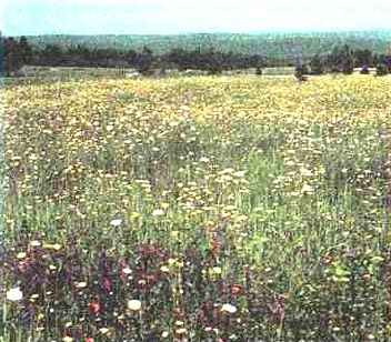
Rice. 34. Blooming steppe is especially beautiful in spring
Antarctica is home to an area of the Antarctic desert characterized by exceptional severity: very low temperatures and strong winds.
So, you, apparently, are convinced that the alternation of natural zones on the plains is explained by the change climatic conditions- geographic latitude. However, scientists have long noted that natural conditions change not only when moving from north to south, but also from west to east. To confirm this idea, let us trace on the map the change of zones in Eurasia from west to east along the 45th parallel - in the temperate zone.
On the coast Atlantic Ocean dominated by sea air masses coming from the ocean, there is a zone of broad-leaved forests, beech, oak, linden, etc. grow. When moving to the east forest zone replaced by a zone of forest-steppe and steppe. The reason is a decrease in the amount of precipitation. Further to the east, precipitation becomes less and the steppes pass into deserts and semi-deserts, which further east are again replaced by steppes, and near The Pacific- zone mixed forests... These coniferous-deciduous forests amaze with their richness and diversity of plant and animal species.
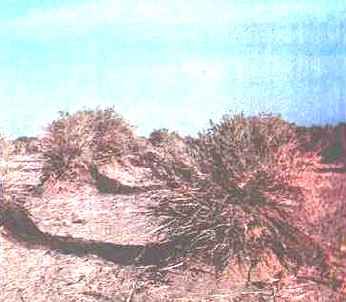
Rice. 35. Due to the lack of moisture, plants in the desert do not form a continuous cover
What explains the alternation of zones at the same latitude? Yes, all the same reasons - a change in the ratio of heat and moisture, which is due to the proximity or distance from the ocean, the direction of the prevailing winds. There are changes at the same latitudes and in the ocean. They depend on the interaction of the ocean with land, movement air masses, currents.
Latitudinal zoning. The location of natural zones is closely related to climatic zones. Like climatic zones, they regularly replace each other from the equator to the poles due to a decrease in solar heat entering the Earth's surface and uneven moisture. Such a change in natural zones - large natural complexes is called latitudinal zoning. Zoning is manifested in all natural complexes, regardless of their size, as well as in all components of the geographic envelope. Zoning is the main geographic pattern.
Rice. 36. Coniferous forest
Altitudinal zonality. The change of natural zones, as you know, occurs not only on the plains, but also in the mountains - from the foot to their peaks. Temperature and pressure decrease with altitude, precipitation increases to a certain height, lighting conditions change. In connection with the change in climatic conditions, there is also a change in natural zones. Changing zones, as it were, encircle mountains at different heights, therefore they are called altitudinal belts. The change of altitude zones in the mountains is much faster than the change of zones on the plains. It is enough to climb 1 km to be convinced of this.
The first (lower) altitudinal belt of mountains always corresponds to the natural zone in which the mountain is located. So, if the mountain is in the taiga zone, then when you climb to its top, you will find the following altitudinal belts: taiga, mountain tundra, eternal snow. If you have to climb the Andes near the equator, then you will start your journey from the belt (zone) of equatorial forests. The pattern is as follows: the higher the mountains and the closer they are to the equator, the more altitudinal zones and the more diverse they are. In contrast to zoning on the plains, the alternation of natural zones in the mountains is called altitudinal zoning or altitudinal zoning.
Rice. 37. Savannah during the dry season
The law of geographic zoning also manifests itself in mountainous areas. We have already considered some of them. From geographic latitude change of day and night, seasonal changes depend. If the mountain is near the pole, then there is a polar day and a polar night, a long winter and a short cold summer. In the mountains at the equator, day is always equal to night, there are no seasonal changes.
- How does a natural complex differ from a geographic envelope?
- Natural complexes are very diverse. Which ones are called natural areas?
- Highlight the main features of the concept of "natural zone".
- What are the features of the location of natural areas on the continents and in the ocean?
- What latitudinal zoning and altitudinal zonality?
- Which mountains have the greatest number of altitudinal zones, which have the smallest? Why?
Natural zones of the earth's surface and moisture conditions in different parts of the continents do not form continuous stripes parallel to the equator. Only in and on some large plains do they stretch in a latitudinal direction, replacing each other from north to south. More often they are replaced in the direction from the coasts of the oceans to the interior of the continents, and sometimes they stretch almost along the meridians.
The location of natural zones on the continents is disturbed by mountains. In the mountains, natural zones replace each other from foothills to peaks, altitudinal zoning is manifested here.
Natural zones are formed in: from the equator to the poles, properties change surface waters, composition of flora and fauna. There is also vertical zoning. However, oceanic natural complexes do not have pronounced external differences.
There is a great variety of natural complexes on Earth. However, against the background of this diversity, large parts stand out - natural zones and. This is due to the different ratios of heat and moisture that the earth's surface receives.
Formation of natural zones
The uneven distribution of solar heat over the Earth's surface is the main reason for the heterogeneity of the geographic envelope. In almost every land area, the oceanic parts are better humidified than the inland, continental regions. Humidification depends not only on the amount of precipitation, but also on the ratio of heat and moisture. The warmer, the more moisture precipitated with precipitation evaporates. The same amount of precipitation can lead to excessive moisture in one zone and insufficient in the other. So, the annual amount of precipitation of 200 mm in the cold subarctic zone is excessive (swamps are formed), and in hot tropical zones sharply insufficient (deserts exist).
Due to differences in the amount of solar heat and moisture inside geographic zones natural zones are formed - large territories with uniform temperature and moisture conditions, features of surface and ground waters, similar soils, and wildlife.
Features of the natural zones of the continents
In the same natural areas on different continents vegetation and animal world have similar features.
At the same time, in addition to the climate, other factors also influence the distribution of plants and animals: the geological history of continents, the relief and features of rocks, man. The unification and separation of continents, changes in their relief and climate in the geological past have become the reason that in similar natural conditions, but they live on different continents different types plants and animals. African savannas, for example, are characterized by antelopes, buffaloes, zebras, African ostriches, and several species of deer, armadillos and an ostrich-like bird, rhea, are common in the South American savannas. On each continent, there are endemic species (endemics), characteristic only of this continent.
Under the influence of human activity geographic envelope is undergoing significant changes. To retain representatives organic world and typical natural complexes in all natural zones of the world create specially protected areas - reserves, etc. national parks, unlike nature reserves, nature conservation is combined with tourism and recreation of people.
What determines the formation of natural zones? What natural areas stand out on our planet? You can answer these and some other questions by reading this article.
Natural zoning: the formation of natural zones in the territory
The so-called our planet is the largest. It is very heterogeneous, both in the vertical section (which is expressed in the vertical zonality) and in the horizontal (latitudinal), which is expressed in the presence of various natural zones on Earth. The formation of natural zones depends on several factors. And in this article we will talk specifically about the latitudinal heterogeneity of the geographic envelope.
The natural zone is a component of the geographic envelope, which is distinguished by a certain set of natural components with their own characteristics. These components include the following:
- climatic conditions;
- the nature of the relief;
- hydrological grid of the territory;
- soil structure;
- organic world.
It should be noted that the formation of natural zones depends on the first component. However, natural zones usually get their names from the nature of their vegetation. After all, flora is the most striking component of any landscape. In other words, vegetation acts as a kind of indicator that reflects the deep (those that are hidden from our eyes) processes of the formation of a natural complex.
It should be noted that the natural zone is the highest level in the hierarchy of physical and geographical zoning of the planet.
Natural zoning factors
Let us list all the factors of the formation of natural zones on Earth. So, the formation of natural zones depends on the following factors:
- Climatic features of the territory (this group of factors should include temperature regime, the nature of humidification, as well as the properties of the air masses prevailing over the territory).
- The general nature of the relief (this criterion, as a rule, affects only the configuration, boundaries of a particular natural zone).
The formation of natural zones can also be influenced by the proximity to the ocean, or the presence of powerful ocean currents off the coast. However, all of these factors are secondary. The main root cause of natural zoning is that different parts (belts) of our planet receive unequal amounts of solar heat and moisture.
Natural areas of the world
What natural zones do geographers distinguish on the body of our planet today? Let's list them from the poles to the equator:
- Arctic (and Antarctic) deserts.
- Tundra and forest-tundra.
- Taiga.
- Broad-leaved forest zone.
- Forest-steppe.
- Steppe (or prairie).
- Semi-desert and desert zone.
- Savannah zone.
- Zone of tropical rainforests.
- Wet zone (gilea).
- Zone of rain (monsoon) forests.
If we look at the map of the natural zoning of the planet, we will see that all natural zones are located on it in the form of sub-latitudinal belts. That is, these zones tend to stretch from west to east. Sometimes this sub-latitudinal direction can be violated. The reason for this, as we have already said, is the features of the relief of a particular territory.
It is also worth noting that there are simply no clear boundaries between natural areas (as shown on the map). So, almost each of the zones smoothly "flows" into the neighboring one. At the same time, border "zones" can very often form at the junction. For example, these are semi-desert or forest-steppe zones.
Conclusion
So, we found out that the formation of natural zones depends on many factors. The main ones are the ratio of heat and moisture in a particular area, the properties of the prevailing air masses, the nature of the relief, and so on. The set of these factors is the same for any territory: mainland, country or small region.
Geographers distinguish over a dozen large natural zones on the surface of our planet, which are elongated in the form of belts and replace each other from the equator to the polar latitudes.
The natural complexes of the Earth are very diverse. These are hot and icy deserts, evergreen forests, endless steppes, bizarre mountains. This diversity is the unique beauty of our planet.
You already know how natural complexes, “continents”, “ocean” were formed. But the nature of every continent, like every ocean, is not the same. Various natural zones are formed on their territory.
Theme: Earth Nature
Lesson: Natural Areas of the Earth
1. Today we will find out
Why are natural areas formed,
About the patterns of placement of natural zones,
Features of the natural zones of the continents.
2. Formation of natural zones
The natural zone is a natural complex with uniform temperatures, moisture, similar soils, flora and fauna. The natural zone is called by the type of vegetation. For example, taiga, deciduous forests.
The main reason for the heterogeneity of the geographic envelope is the uneven redistribution of solar heat on the Earth's surface.
In almost every climatic zone of the land, the oceanic parts are more humid than the inland, continental ones. And it depends not only on the amount of precipitation, but also on the ratio of heat and moisture. The warmer, the more moisture precipitated with precipitation evaporates. The same amount of moisture can lead to excess moisture in one belt and insufficient moisture in the other.
Rice. 1. Swamp
So, the annual amount of precipitation is 200 mm in the cold subarctic zone - excessive moisture which leads to the formation of swamps (see Fig. 1).
And in hot tropical zones - sharply insufficient: deserts are formed (see Fig. 2).
Rice. 2. Desert
Due to differences in the amount of solar heat and moisture, natural zones are formed within the geographic zones.
3. Patterns of placement
There is a clear pattern in the placement of natural zones on the earth's surface, which can be clearly traced on the map of natural zones. They stretch in a latitudinal direction, replacing each other from north to south.
Due to the heterogeneity of the relief of the earth's surface and moisture conditions in different parts of the continents, natural zones do not form continuous stripes parallel to the equator. More often they are replaced in the direction from the coasts of the oceans to the interior of the continents. In the mountains, natural zones replace each other from the foothills to the peaks. Altitudinal zonality is manifested here.
Natural zones are also formed in the World Ocean: from the equator to the poles, the properties of surface waters, the composition of vegetation and fauna change.
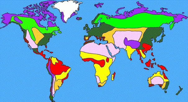
Rice. 3. Natural areas of the world
4. Features of the natural zones of the continents
In the same natural zones on different continents, the flora and fauna have similar features.
However, the features of the distribution of plants and animals, in addition to climate, are influenced by other factors: the geological history of continents, relief, people.
The unification and separation of continents, changes in their relief and climate in the geological past have become the reason that different species of animals and plants live in similar natural conditions, but on different continents.
For example, antelopes, buffaloes, zebras, African ostriches are characteristic of the African savannas, and several species of deer and a flightless bird, the rhea, similar to an ostrich, are common in the South American savannas.
On every continent there are endemics - both plants and animals, characteristic only of this continent. For example, kangaroos are found only in Australia, and polar bears are found only in the arctic deserts.
Geofocus
The Sun heats the spherical surface of the Earth unevenly: the areas above which it stands high receive the most heat.
Above the poles, the Sun's rays only glide over the Earth. The climate depends on this: hot at the equator, harsh and cold at the poles. The main features of the distribution of flora and fauna are also related to this.
Wet evergreen forests are located in narrow stripes and patches along the equator. "Green hell" - this is how many travelers of the past centuries called these places, who had to visit here. A solid wall is high multi-tiered forests, under the dense crowns of which dusk constantly reigns, monstrous humidity, constant heat, there is no change of seasons, showers regularly fall down with an almost continuous stream of water. Equator forests are also called permanent rainforests. The traveler Alexander Humboldt called them "gileya" (from the Greek. Hyle - forest). Most likely, this is how they looked moist forests Carboniferous period with giant ferns and horsetails.
The rainforests of South America are called “selva” (see Figure 4).
Rice. 4. Selva
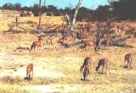
Savannah is a sea of grasses with rare islets of trees with umbrella crowns (see Fig. 5). Vast expanses of these amazing natural communities are found in Africa, although there are savannas in South America, and in Australia and India. Distinctive feature savannah is alternating between arid and wet seasons, which take about six months, replacing each other. The fact is that for subtropical and tropical latitudes, where the savannahs are located, is characterized by a change in two different air masses - humid equatorial and dry tropical. Monsoon winds, bringing seasonal rains, significantly affect the climate of the savannahs. Since these landscapes are located between very humid natural zones of equatorial forests and very dry zones of deserts, they are constantly influenced by both. But moisture is not present long enough in the savannas for multi-tiered forests to grow there, and dry "winter periods" of 2-3 months do not allow the savannah to turn into a harsh desert.
Rice. 5. Savannah
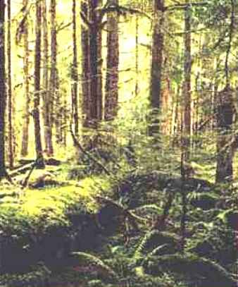
The natural zone of the taiga is located in the north of Eurasia and North America(see Fig. 6). On the North American continent, it stretched from west to east for more than 5 thousand km, and in Eurasia, originating on the Scandinavian Peninsula, spread to the shores of the Pacific Ocean. The Eurasian taiga is the largest continuous forest zone on Earth. It occupies more than 60% of the territory Russian Federation... Taiga contains huge reserves of wood and supplies a large amount of oxygen to the atmosphere. In the north, the taiga smoothly turns into the forest-tundra, gradually taiga forests are replaced by light forests, and then by separate groups of trees. Farthest of all, the taiga forests enter the forest-tundra along the river valleys, which are most protected from strong northern winds... In the south, the taiga also smoothly turns into coniferous-deciduous and broad-leaved forests. In these areas, people intervened in natural landscapes for many centuries, so now they are a complex natural-anthropogenic complex.
Rice. 6. Taiga
Under the influence of human activity, the geographic envelope is changing. Swamps are being drained, deserts are being watered, forests are disappearing, and so on. Thus, the appearance of natural zones changes.
Homework
Read § 9. Answer the questions:
· What does the territory moistening depend on? How do different moisture conditions affect natural complexes?
· Are there natural areas in the ocean?
Bibliography
The mainI am
1. Geography. Land and people. Grade 7: Textbook for general education. uch. / A. P. Kuznetsov, L. E. Savelyeva, V. P. Dronov, "Spheres" series. - M .: Education, 2011.
2. Geography. Land and people. 7th grade: atlas, "Spheres" series.
Additional
1. N. A. Maksimov. Behind the pages of a geography textbook. - M .: Education.
Literature for preparing for the State Examination and the Unified State Exam