Topographic materials include: plan, map and profile. Topographic plan called a reduced and similar image on paper of horizontal projections of terrain areas. As shown above, a similar image is obtained by orthogonal projection of sections earth surface not exceeding 20 × 20 km per horizontal plane. In a reduced form on paper, such an image is called a plan of the area.
An image of large areas of the earth's surface (more than 20 × 20 km) on a plane cannot be obtained without distortion, i.e., with full similarity being preserved. Such areas are projected orthogonally onto the surface of the reference ellipsoid, and then from the surface of the ellipsoid, according to certain mathematical laws, called cartographic projections, they are transferred onto a plane. The image obtained in this way, reduced on paper, of significant areas of the earth's surface (more than 20 km), taking into account the curvature of the earth, is called a map. The map compiled in the Gauss-Kruger projection is called topographic map.
On topographic plans and maps they show the situation and the terrain. Situation is called a set of contours and objects of the terrain. The situation is a planned part of the terrain (forest, meadow, arable land, hydrography, buildings, roads, water lines, hydraulic facilities, etc.). It is depicted on plans and maps with conventional topographic signs.
Relief is called a set of irregularities on the earth's surface. Relief - the high-altitude part of the area. It is depicted on maps and plans in the form of contour lines - smooth curved lines passing through points with equal heights (marks).
The main requirements for topographic maps and plans are accuracy and clarity.
Accuracy is understood as the correspondence of the location, shape and size of objects on plans and maps of reality. The planes are characterized by visual perception of the image of the earth's surface, its characteristic features and features.
The main characteristics of the accuracy of plans and maps are scale, and clarity - conventional topographic signs and color design. In addition to plans and maps, topographic materials include terrain profiles, which are a reduced on paper image of a vertical section of the Earth's surface in a given direction. Terrain profiles are the topographic basis for the preparation of project documentation required for the construction of railways and highways, water supply and sewerage lines and other communications.
3.3 Scope of plans and maps. Scale accuracy
When depicting areas of the earth's surface on a plan or map, the sizes of these areas are reduced by a known number of times. The degree of reduction of lines on the plan in relation to their horizontal distances (projections) on the ground is called scale.
Scales can be numerical, linear, and transverse. The numerical scale is called an expression in the form of a fraction, the numerator, which is a unit, and the denominator is a number that shows how many times the lines on the plan are reduced in relation to their horizontal projections on the ground. For example, the expression 1: 2000 shows that 1 cm on the plan contains 2000 cm (20 meters) of terrain. Knowing the numerical scale of the plan, it is possible to determine the corresponding length of the line on the plan by the length of the terrain line and vice versa. For example, if the length of the line on the plan is 3.23 cm, and the scale of the plan is 1: 2000, then the corresponding line on the ground will be
d = 3.23 cm × 2000 = 6460 cm = 64.60 m.
Or, if the length of the line on the ground is 200 m, then on a plan of scale 1: 5000 the length of the corresponding segment will be
l = 200 m: 5000 = 0.04 m = 4 cm.
In order not to make such calculations, they usually use special graphic scales: linear and transverse. To build a linear scale, take a straight line and lay equal segments on it, called the base of the scale (Figure 3.3).
The leftmost segment is divided into 10 equal parts. Having calculated the length of the terrain line corresponding to the base of the scale by the numerical scale, the divisions of the linear scale are signed. In Figure 3.3, the scale base is taken as 2 cm. With a numerical scale of 1: 10000, 2 cm on the plan corresponds to 200 m on the ground. Consequently, on a linear scale, the segments to the right of zero will correspond to 200 m on the terrain, and to the left, 20 m each. In order to plot a line equal to 540 m on the terrain on the ground, it is necessary to postpone the segment ab with the help of a compass-measuring device (see Figure 3.3). As you can see, the sections less than 2 mm in this scale are assessed by eye. In order for the distance along the scale to be plotted more accurately, a transverse scale is built. On the line AF (Figure 3.4), the base of the scale (usually 2 cm) is laid several times and the perpendiculars are restored to it from the points obtained. One of the perpendiculars is divided into 10 parts and lines parallel to AF are drawn through the division points. The left segment AO is divided into 10 parts. The upper left base is also divided into 10 equal parts. The points of the upper and lower left bases are connected with oblique lines as shown in Figure 3.4. Figure 3.4 shows that the smallest division of the transverse scale
t = AO / 100 = 2 cm / 100 = 0.2 mm.
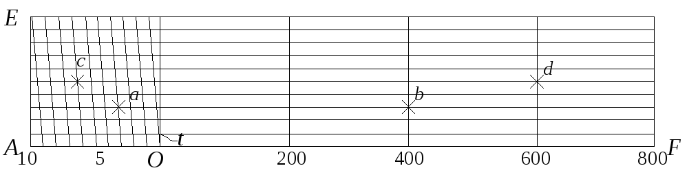
Figure 3.4 - Transverse scale
In Figure 3.4, the transverse scale is painted for a numerical scale of 1: 10000 at a scale base of 2 cm. The distances of 466 and 730 m on the transverse scale are marked with points ab and cd, at which the legs of the measuring compass should be installed. With the naked eye, the segments on the plan, less than 0.1 mm, become indistinguishable and are practically a point. Therefore, the distance on the ground, which corresponds to 0.1 mm on the plan, is usually called the accuracy of the plan scale. In accordance with this, the accuracy of the standard numerical scales of topographic plans and maps is given in Table 3.1. The calculation was carried out according to the formula
t = 0.1 mm M,
where M is the scale denominator.
Table 3.1 - Accuracy of scale of topographic plans and maps
|
Characteristic plans and maps |
Numerical |
Accuracy scale in meters |
Distance on the ground in meters, corresponding to 1 cm of the plan (maps) |
|
|
large-scale | ||||
|
medium-scale | ||||
|
small-scale | ||||
|
large-scale | ||||
|
medium-scale | ||||
|
small-scale | ||||
It can be seen from the data presented that the smaller the denominator of the numerical scale, the larger the scale of the plan or map and the higher its accuracy. The accuracy of the scale allows you to determine which terrain objects can be depicted on a plan or map in the form of a similar figure, and which ones, due to their small size, will turn to a point on the plan. For example, a building 5 m long and 5 m wide at a scale of 1: 50,000 will be displayed on the plan as one point.
The opposite question is also of great practical importance: on what scale is it necessary to draw up a plan so that certain objects of the area are depicted on this plan while maintaining similarity? This question can be answered by analyzing the accuracy of the scale according to Table 3.1. It should be borne in mind that the smallest segment on the plan, which we distinguish as a segment, and not as a point, is 0.2 mm. Therefore, for example, for a scale of 1: 2000, we can distinguish terrain objects that are not less than 0.2 mm on the plan, which corresponds to 0.4 m on the ground.
Scale refers to the degree to which the horizontal spacing of terrain lines is reduced when they are displayed on a plan, map or aerial photograph. Distinguish between numerical and graphic scales; the latter include linear, transverse and transitional scales.
Numerical scale. The numerical scale is expressed as a fraction, the numerator of which is equal to one, and the denominator is a number that indicates the degree of reduction of the horizontal spacing. On the topographic maps ah the numerical scale is signed at the bottom of the map sheet in the form of 1: M, for example, 1: 10000. If the length of the line on the map is s, then the horizontal distance S of the terrain line will be:
S = s * M. (5.1)
In our country, the following scales of topographic maps are adopted: 1: 1,000,000, 1: 500,000, 1: 200,000, 1: 100,000, 1:50,000, 1:25,000, 1:10,000. This series of scales is called standard ... Previously, this series included scales of 1: 300,000, 1: 5000 and 1: 2000.
Linear scale. Linear scale is a graphical scale; it is built in accordance with the numerical scale of the map in the following order:
a straight line is drawn and a segment a of constant length is laid on it several times in a row, called the base of the scale (for a base length of a = 2 cm, the linear scale is called normal); for a scale of 1: 10,000 a corresponds to 200 m,
zero is put at the end of the first segment,
to the left of zero sign one scale base and divide it into 20 parts,
to the right of zero sign several bases,
parallel to the main straight, another straight line is drawn and short strokes are drawn between them (Figure 5.1).
The linear scale is placed at the bottom of the map sheet.
To measure the length of the line on the map, fix it with a solution of a measuring compass, then put the right needle on a whole base so that the left needle is inside the first base. Two readings are read from the scale: N1 - along the right needle and N2 - along the left; the length of the line is equal to the sum of the samples
addition of counts is done in the mind.
Transverse scale. Let's draw a straight line CD and put on it several times the base of the scale - a segment a 2 cm long (Figure 5.2). At the obtained points, restore the perpendiculars to the CD line; on the extreme perpendiculars, set aside a segment of constant length m times up from the line CD and draw lines parallel to the line CD. Divide the extreme left base into n equal parts. Let's connect the i-th base point CA with the (i-1) th point of the line BL; these lines are called transversals. The scale built in this way is called transverse.
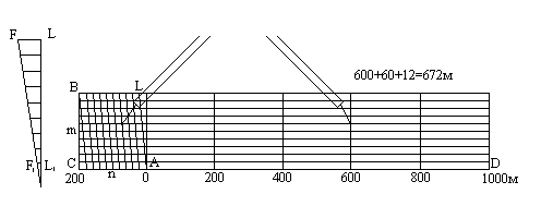
If the base of the scale is 2 cm, then the scale is called normal; if m = n = 10, then the scale is called centesimal.
The smallest division of the transverse scale is equal to the segment F1L1; two adjacent parallel-located segments differ by this length when moving up the transversal and along the vertical line. The theory of the transverse scale consists in the derivation of the formula for the price of its smallest division.
Consider two similar triangles AF1 L1 and AFL, from the similarity of which it follows:
whence F1L1 = FL * (AL1 / AL).
By construction, FL = a / n and (AL1 / AL) = 1 / m. Substitute these equalities into formula (5.2) and get:
With m = n = 10, we have F1L1 = a / 100, that is, at the centesimal scale, the price of the smallest division is equal to one hundredth of the base.
How to use the transverse scale:
with a measuring compass, record the length of the line on the map,
put one leg of the compass on a solid base, and the other on any transversal, while both legs of the compass should be located on a line parallel to the line CD,
the length of the line is made up of three counts: the base count multiplied by the base price plus the left base count multiplied by the left base tick plus the upward transversal count multiplied by the smallest scale division. The accuracy of measuring the length of the lines on the transverse scale is estimated at half the price of its smallest division.
Transitional scale. Sometimes in practice it is necessary to use a map or aerial photograph, the scale of which is not standard, for example, 1: 17500, that is, 2 cm on the map corresponds to 350 m on the ground; the smallest division of the normal transverse centesimal scale will be 3.5 m in this case. Digitization of such a scale is inconvenient for practical work, therefore, proceed as follows. The base of the transverse scale is not taken 2 cm, but calculated so that it corresponds to a round number of meters, for example, 400 m. The length of the base in this case will be a = 400 m / 175 m = 2.28 cm.
If we now construct a transverse scale with the base length a = 2.28 cm, then one division of the left base will correspond to 40 m, and the price of the smallest division will be equal to 4 m.
A transverse scale with a fractional base is called a transient scale.
Scale accuracy. A map or plan is a graphic document. It is generally accepted that the accuracy of graphic constructions is estimated at 0.1 mm. The length of the horizontal distance of the terrain line corresponding to the 0.1 mm segment on the map is called the scale accuracy. The practical meaning of this concept lies in the fact that it is impossible to depict terrain details that have dimensions less than the scale accuracy on a map, and so-called off-scale conventional symbols have to be used.
In addition to the concept of "scale accuracy" there is the concept of "plan accuracy". The accuracy of the plan shows with what error point objects or clear contours are plotted on the plan or map. The accuracy of the plan is estimated in most cases at 0.5 mm; it includes errors of all processes of creating a plan or map, including errors of graphic constructions.
Note to the hostess: professional usage.The scale of the map, as you know, is denoted by a fraction, in which the numerator is always one, and the denominator indicates how many segments of a certain length on the ground correspond to the same segment on the map. How many physical, real centimeters (meters, kilometers) "fit" in one centimeter (meter, kilometer) of the map. For example, on a "milliona" - a map with a scale of 1: 1,000,000 - one centimeter of the map contains a million centimeters - ten kilometers of terrain. And on the "dvuhsotka" (scale 1: 200,000) - only two kilometers.
Maps are referred to as "small-scale" and "large-scale", as well as "smaller" and "larger". The meaning of these words is not so obvious: is small-scale with a smaller denominator of scale, or what? I, in any case, have been confused with this for a long time.
So, the mnemonic rule: what smaller looks like the same object on one map compared to another, so smaller the scale of the first is also considered relative to the second. In this case, the denominator of the scale of the first map, on the contrary, is more.
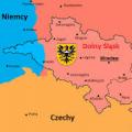
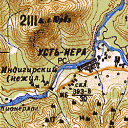
One and the same Ust-Nera becomes everything from left to right larger- the scale of the maps is getting more and more large:
1:1 000 000 → 1:500 000 → 1:200 000:
![]()
What about English? It is not at all necessary that the adjectives are the same - quite often we have discrepancies with them "exactly the opposite." So it is here: after all, they can easily construct adjectives, operating just the values of the denominator of the scale? But in this particular case, it's a coincidence: a map of a smaller scale, small-scale map. Larger scale - larger scale, large-scale map.
Map scale
Map scale
the degree of reduction of objects on the map relative to their size on the earth's surface. It is constant only on terrain plans, on maps it changes from point to point in different directions - it all depends on the properties of the cartographic projection.
In Russia, a certain scale system is adopted for topographic maps:
On nautical and some English and American maps you can find the English system of scales: one English mile is equal to 1.609 km, it contains 63,360 inches.
The scale is indicated on the maps in different versions. The numerical scale is a fraction with one in the numerator, it shows how many times the length on the map is less than the corresponding length on the ground (for example, 1: 1,000,000). Linear (graphic) scale is given in the form of a ruler divided by centimeters, with captions indicating distances on the ground, which makes it easier to measure on the map. The named scale is indicated in the form of a signature, for example. "1 cm 10 km".
Geography. Modern illustrated encyclopedia. - M .: Rosman. Edited by prof. A.P. Gorkina. 2006 .
See what "map scale" is in other dictionaries:
map scale- - Topics Oil and gas industry EN map scale ... Technical translator's guide
It is necessary to transfer the content of this article to the article "Interfax.by Maps". You can help the project by combining articles. If you need to discuss the feasibility of combining, replace this template with the template ((to the union)) and add ... ... Wikipedia
Noun., M., Uptr. cf. often Morphology: (no) what? scale, what? scale, (see) what? scale than? scale, about what? about the scale; pl. what? scale, (no) what? scale, what? scale, (see) what? scale than? scale, about what? O… … Dmitriev's Explanatory Dictionary
Cards- * CARDS, solid depiction on the plane of part or all of the earth's surface in a variable scale. Due to the spherical nature of the earth, b. depicted exactly with the preservation of the similarity of figures and areas only on the globe, and the numerical ... Military encyclopedia
Google Maps ... Wikipedia
Geographic maps designed to provide the flight charter with navigation data necessary in preparation for flight and in flight. By appointment K. and. are divided into flight, airborne and special. Flight charts used for ... ... Encyclopedia of technology
- (German Masstaq, from German Mass measure). 1) a measure, a linear measure, taken in the drawings in a reduced form. 2) in artillery: a copper ruler with the designation on it of the caliber of guns, shells and the most common measures in artillery. Dictionary of foreign words ... Dictionary of foreign words of the Russian language
Maps characterizing the location or conditions for the formation of mineral deposits. Compiled on the basis of lists of mineral deposits, geological survey data, prospecting and exploration; often with ... ... Great Soviet Encyclopedia
- (German Maβstab; from Maβ measure and Stab stick * a. scale; n. Maβstab, Skala; f. echelle; and. escala) the ratio of the length of a line in a drawing, plan, map, subject model to the length of the corresponding line in nature. Ha geogr. maps distinguish between the main M. ... ... Geological encyclopedia
Seismic microzoning maps- Maps of seismic microzoning: maps at a scale of 1: 25000 1: 2000, developed for urban areas, settlements or individual residential areas, as well as industrial facilities. For linear structures, the scale is allowed ... ... Official terminology
Books
- A political map of the World. Coats of arms and flags. Scale 1: 58,000,000,. Political Map world is printed on thick cardboard with glossy double-sided lamination. Contains images of coats of arms and flags. The map can be used as a reference and informational and ...
- The Russian Federation. Physical tabletop map. Scale 1:15 500 000,. Physical map of Russia. The map shows the territory of Russia ( physical map) and given reference Information O highest peaks, volcanoes, rivers, lakes, etc. The card can be used ...