Lesson topic. The world and Russia at the beginning of the era of the great geographical discoveries
Targets and goals: to acquaint with the main reasons and consequences of the great geographical discoveries; to identify the specific features of Russian geographical discoveries; characterize the history of Russia as part of world history.
Planned results:
subject: to establish synchronic links between the history of Russia and the countries of Europe and Asia in the period under study; use information from a historical map as a source of information; to make judgments about the meaning and role of the Great Geographical Discoveries in world history and in the history of Russia; use the methods of historical analysis (comparison and generalization of facts, disclosure of cause-and-effect relationships, goals and results of the activities of historical figures, etc.); evaluate the results of life based on humanistic attitudes, national interests Of the Russian state;
metasubject UUD
1)communi rolling: organize educational cooperation and joint activities with the teacher and peers; formulate, argue and defend their opinions;
2)regulatory: formulate, with the support of the teacher, new tasks in educational and cognitive activities; plan ways to achieve educational goals; correlate your actions with the planned result, monitor your activities in the process of achieving the result;
3)cognitive: analyze graphic, artistic, audiovisual information; generalize facts; collect and record information, highlighting the main and secondary; apply initial research skills in solving search problems;
lich nostal UUD: to form and develop a cognitive interest in the past of their homeland; respect the historical heritage; to comprehend the social and moral experience of previous generations.
Equipment: textbook, package with working material for work in groups, card "Great geographical discoveries». i
Lesson type: a lesson in the discovery of new knowledge.
During the classes
1.Organizational moment
2.Updating basic knowledge
What do you think, has humanity always strived to discover new worlds?
Who and when made the first voyage around Africa?
Answer. in the 6th century BC
the mediterranean was ruled the most ancient peoples Phoenicians who reached Indian Ocean going around Africa.
The most important historical confirmation of this is the mention of this expedition in the Bible.
The Phoenicians' voyage around the whole of Africa lasted for about three years. Having laid the beginning of their route through the Red Sea, the expedition returned to the Mediterranean Sea through the Strait of Gibraltar.
-What discovery do historians attribute to the geographical discoveries made by the Vikings?
Answer. the tribes of the Normans discovered significant territories. The Normans (northern people) should include the tribes of Danes, Swedes and Norwegians. The main occupation of the Scandinavians was sea fishing - robbery and trade. The Scandinavians called such people Vikings - people who left home, sea warriors who left for prey. In the east, Viking ships conquered the Baltic Sea, along the Dnieper River they reached the shores of the Black and Caspian Seas. Their fleet reached Byzantium and even to Arab Caliphate.
on westward they hit the northern shores of France and the coast of England. Then they discovered many islands, including Greenland. At the end of the 10th century, they managed to swim right up to the coast North America, however, they did not manage to settle here.
3. Motivational-target stage
In the XV century. the expression appeared: "The ships sailed on the Sea of Darkness." By sea The Europeans called the darkness Atlantic Ocean... What made the Spanish and Portuguese sailors set off on long journeys? What are the consequences of this led? Made whether Russian travelers are long-term trips to other country? We will discuss these and other questions with you. in our lesson.
Lesson topic: "The world and Russia at the beginning of the era of the great geographical discoveries."
What questions do we have to answer?
Lesson plan
1.Great geographical discoveries: preconditions and periodization.
2. The beginning of Russian geographical discoveries and their specificity.
3. Consequences of the great geographical discoveries.
Problematic question
Why did the great geographical discoveries change the picture of the world?
4.Work on the topic of the lesson
1. Great geographical discoveries: preconditions and periodization
We found out that even in ancient times, mankind was constantly developing new lands. But can the travels of the ancient Phoenicians be called geographical discoveries?
After reviewing the supplementary material, answer the questions.
Additional material
Icelander Eirik, nicknamed Red because of his fiery red hair, with a team of 32 people went in 982 in search of new country... He managed to discover the island, circling the southern tip of which he founded on west bank two colonies. He called this land Greenland (green country) in the hope that this name will attract new settlers. Indeed, in just a few years there were already 3,000 inhabitants.
Some scientists believe that the real discoverer of America is not Christopher Columbus, but the Viking Leif Eriksson. At the beginning 18th century would whether Icelandic sagas have been published, first of all The Saga of the Greenlanders and The Saga of Eric the Red, which talked about the Scandinavian campaigns in the mysterious country of Vinland (the land of grapes). However, it took a long time to establish the location of this country. Leif's material traces in the New World were excavated in the 1960s. in Canada, the Norwegian ethnographer and writer Helge Ingstad (1899-2001). He found the remains of a settlement on the northern tip of Newfoundland, which was later classified as Norman.
The Saga of the Greenlanders tells the story of the journey of Leif, the son of Eirik. He and a team of 35 people reached the shores of a barren country, which he called Helluland (land of stones). Further south they found small island... The northerners who sailed from Greenland were delighted with the lush green meadows and rivers rich in fish. They found wild grapes there and named the land Vinland. Researchers believe that the Vikings sailed far south along east coast North America. Then they decided to spend the winter and built "big houses". After wintering, Leif, having loaded the ship with wood and grapes, set off back to Greenland.
After a while Leif's brother Thorvald went to Vinland. The expedition consists of one ship, 31 people, including Thorvald. The expedition spent more than three years in America, and its base was Leif's home.
During this time, the Vikings undertook several campaigns in the local area. During a campaign in the second year of his stay in Vinland, Torvald died from an arrow in a skirmish with the Indians or Eskimos. He was buried in America.
(Based on materials from the site "History of the Earth" - istorizemli.rf)
Questions about the text
Can Eirik's trip be called a geographical discovery?
And what about the Vikings' journey to America?
(Answers of students.)
Output: Therefore, geographical discoveries are not easy
visiting new lands, but also their economic development, establishing relations with local population. P. 8 underline the definition.
What is the era of travel and largest discoveries committed by Europeans in the late 15th-mid-17th century?
When did the era of the great geographical discoveries begin?
Late 15th - mid 17th century
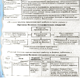
Divide into three groups. Working with diagrams, determine the prerequisites, causes and chronology of the great geographical discoveries.
First group - preconditions for the great geographical discoveries.
Second group - the reasons for the great geographical discoveries.
Third group - chronology of the Great Geographical Discoveries.
Results of work.
Anchoring:
-What were the sea sailing ships a new type, on which sailors set sail during the Great Geographical Discoveries
-One of the reasons for the Great Geographical Discoveries was the desire of Europeans to find new ways --- (India and China)
- Who owns this discovery?
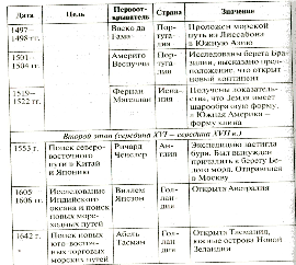
A) swimming to the southwest of India Vasco da Gama
B) an attempt to discover the north - Richard Chancellor
the eastern route to China and Japan
C) the discovery of America by Christopher Columbus
D) description of the open lands of Amerigo Vespucci
Of the New World
D) the journey proved by Fernand Magellan
spherical earth
2. The beginning of Russian geographical discoveries and their specificity
Russia was also involved in the process of developing new territories. I propose to make sure of this by making a virtual expedition to the past.
Assignment to groups:
Working from item 2 of paragraph 1first and second group called expeditions of Russian travelers (pp. 10-11)
Working with item 2third group names the reasons less active participation of Russia in geographical discoveries in comparison with Spain, Portugal, England.
At the end of the 15th century. the Grand Duke of Moscow and the Sovereign of All Russia Ivan 3 ordered to organize an expedition to develop the Urals and Western Siberia.
In 1483, in the Trans-Urals, a military expedition was led by Fyodor Kurbsky Cherny and Ivan Saltyk Travvin. Their detachment climbed the Vishera River, a tributary of the Kama, crossed the Ural Mountains and entered the land and Pelymsky of the Asyka principality. Then the squad Kurbsky moved further down the Tavda River, passing along the border Of the Tyumen Khanate, and Khan Ibak, who walked in friendly relations with Moscow, missed them without battle. Detachment came out from Tavda to Tobol, Irtysh and Ob. There they are fought " Yugra, capturing nothow many princes. The chronicler noted: “From Siberia we went along the Irtysh down the river, fighting, yes to the Great Ob River to the Ugra Land. "
At the end of 1499, Ivan III again sent his army to the Siberian lands. This time they were led by the Moscow governors Semyon Kurbsky, Pyotr Ushaty and Vasily Brazhnik Gavrilov. A total of 4 thousand soldiers were collected, and they all went on skis. Russian soldiers went to a practically uninhabited land. After passing along the channel of the Pechora River, they came to the Ural Mountains. Then they split into two groups. Brazhnik Gavrilov led his detachment along the Yugorsky crossing, well-known to Russian fishermen. And the second detachment, led by Kurbsky and Ushaty, moved north through the passage in the Ural Mountains. Finding themselves on the Ugra land, the Russian troops headed along the Sygve tributary of the Northern Sosva River and soon reached the fortified town of Lyapin. The town was taken by storm. Other military operations were also successful, as a result of which the Russian warriors managed to occupy 40 fortified towns and capture 58 people - princelings, tribal leaders, elders.
Realizing that there was no point in resisting, a delegation of residents living near the mouth of the Ob arrived to them. They agreed to accept Russian citizenship and make peace. Then the regiments turned back and returned to Russia in 1500.
Russian inhabitants of the coast Of the White Sea and the Arctic Ocean (Pomors) discovered the Kolguev Island and the straits leading to the Kara Sea, reached Novaya Zemlya, approached the Bear Island and the eastern shores of the Spitsbergen archipelago.
Afanasy Nikitin, a merchant from Tver, is considered the first Russian merchant who visited India (a quarter of a century before the Portuguese Vasco da Gama). Travel goals of Afanasy Nikitin: a commercial expedition along the Volga as part of a caravan river vessels from Tver to Astrakhan, establishing economic ties with Asian merchants who trade along the Great Silk Road. In 1468 Nikitin and his comrades equipped two ships, loading them with different goods for trade. The goods of Afanasy Nikitin, as can be seen from his notes, were junk, that is, furs. The trip was described in the book "Voyages across the Three Seas". During the "walk" Nikitin visited Persia, Arabia, India and Africa.
Why do you think Russia (in comparison with Spain and Portugal) did not take an active part in the Great Geographical Discoveries?
Writing in a notebook
Specificity of Russian geographical discoveries:
1) insufficient development of commodity-money relations, therefore, attention to geographical discoveries was not so strong.
2) lack of money for organizing long-distance expeditions, since a lot of money was spent on overcoming the dependence of the Russian lands on the Horde, and the process of forming a unified Russian state was not completed;
3) lack of access to non-freezing seas;
4) the lack of a fleet, without which it was impossible to compete on an equal footing with Western European countries.
Which country became the largest colonial power as a result of geographical discoveries?
3. Consequences of the great geographical discoveries
Using the "Brainstorming" technique, guess what the great geographical discoveries were.
(In the course of the assignment, a list is drawn up.)
Writing in a notebook
Significance of the great geographical discoveries:
1) the rapid development of world trade and the beginning of the development of the world world economy; the opening of new trade routes and the relocation of major trade routes to the oceans;
2) geographic exploration of the Earth;
3) the development of science and technology, the emergence of ships of a new type;
3) the development of the scientific outlook and outlook of Europeans;
4) a change in the social structure of society - the emergence
new layers;
5) the inflow of precious metals to Europe;
6) the development of new agricultural crops - new food products have appeared in Europe: potatoes, corn, tomatoes, pumpkin, various spices, chocolate and cocoa.
However, the Great Geographical Events also had negative consequences. For example, the influx of precious metals into Europe has over time led to inflation. Piracy and the slave trade flourished in full bloom. The colonial system began to emerge. The culture of some colonized peoples, for example, the Indians of the New World, was destroyed.
4. Summing up the results of the lesson. Reflection.
What do you think, for what purpose H. Columbus, having landed on the shore, unfurled the royal flag?
I invite you to evaluate your work in the lesson, continuing the following phrases:
Today I learned that ...
I understand that...
Complete one of the tasks in the Thinking, Comparing, Reflecting rubric on p. 13, 14 textbooks (2 or 4).
Task 2. Find out the reasons for geographical discoveries common to Russia in Europe and Asia. Argument your answer with quotes from the text of the textbook
4 task. What were the negative consequences of the Great Geographical Discoveries? Why did the struggle between European states intensify with the emergence of their colonies?
The great past of the Soviet people Anna Pankratova
6. Scientific expeditions and geographical discoveries of Russian travelers in the 18th century
In the 18th century, the Russians continued to explore the Arctic, Siberia, the Amur region, the coast and islands of the Pacific Ocean. The Russian people are the leaders in the great geographical discoveries in the Arctic Ocean and in the northern part of the Pacific Ocean. The exploration of the Pacific Ocean was completed by the discovery in its southern part of Antarctica.
Already the expedition of Semyon Dezhnev proved the existence of the sea strait between Asia and America. But this discovery was forgotten. Peter I, shortly before his death, drew up a plan for a new Kamchatka expedition, which he instructed to again explore the northeastern coast of Asia and establish whether it connects with America. The expedition was headed by the Dane Bering, who served in the Russian Navy. During the first expedition (1728–1730), Bering reached the strait, which was later named after him. But he did not dare to continue sailing to the shores of America.
Bering was distinguished by excessive caution and did not show any interest in scientific discoveries... Aleksey Ilyich Chirikov, who came from a poor noble family, was appointed Bering's assistant. He graduated from the "mathematical-navigation" school in Moscow, where he showed great ability and curiosity. In 1716, Chirikov was transferred to the Naval Academy, which trained future officers in navigation. At the academy, Chirikov was especially fond of geography, taking an interest in the life of the most remote corners of the earth. He listened with enthusiasm to stories about the campaigns and exploits of Dezhnev, Poyarkov, Khabarov, Atlasov and other Russian travelers and navigators. He had a dream to become an explorer and perform feats following the example of these courageous travelers. In 1721, Chirikov successfully graduated from the Naval Academy and was retained as a teacher. His outstanding abilities drew attention to him, and a few years later Alexey Chirikov was assigned to Bering's expedition to explore Kamchatka.
At the beginning of the 1840s, a second expedition was organized, led by Bering and Chirikov. Actual leader new expedition there was Chirikov. The expedition had not only scientific and geographical, but also political goals. The Russian government sought to strengthen its influence in the Far East and especially in the Arctic and Pacific oceans. After a month and a half sailing, the sailors saw the snow ridges of the American coast. This was Alaska. Alexey Chirikov was the first to reach the shores of America.
The Bering-Chirikov expedition had a great scientific significance... She finally established the outlines of the northern shores of Asia and America. Chirikov drew up a map of the 1741 campaign, which is the first map in the world, where, based on specific data, North America is shown, an accurate geographical position Kamchatka and the islands adjacent to North America.
Chirikov was not only a skillful and brave navigator and an inquisitive explorer, but also a patriotic scientist. He well understood Peter's plan on the need to strengthen security in Pacific and offered to explore the coast Of the Far East, in order to build fortresses here and, under their cover, to develop the riches of the Far Eastern region, discovered by Russian travelers.
But the tsarist government did not appreciate the works of Chirikov. In November 1748, Chirikov died in dire need. Like all remarkable Russian scientists, Chirikov disinterestedly gave his work and his life for the benefit of science.
During the 18th century, the Academy of Sciences organized a large number of scientific expeditions to different areas of the state to study the nature of the country, the way of life and the history of the peoples inhabiting it. These expeditions have collected a huge amount of material that has enriched Russian and world science. Particularly important was the new Kamchatka expedition, one of the participants of which - S. P. Krasheninnikov - wrote a wonderful work "Description of the Kamchatka Land".
A detailed description of the American coast (Alaska) and the adjacent islands was left by Grigory Shelekhov, who made repeated trips to the Aleutian Islands and Alaska in the 70s and 80s of the 18th century.
In the interests of large entrepreneurs and to counter British competition, a Russian-American company was formed at the end of the 18th century, which was granted the right to exploit Alaska. In 1867, the tsarist government sold Alaska to America.
From the book Secrets of the Lost Expeditions the author Kovalev Sergey AlekseevichLittle-known deaths of Russian travelers in the Arctic Date Available information 1184 Tribute collectors were sent from Novgorod to Zavolochye, Pechora and Yugra, but all of them were killed by the Chudyu. 1222 In the Throat of the White Sea due to ignorance of the current
From the book How people discovered their land the author Tomilin Anatoly NikolaevichAbout cloves, peppers and new geographical discoveries The most violent events in the 17th century developed in the southern insular part of the Asian continent. Powerful maritime powers sought to seize power on the islands. Gold, gems and spices - pepper and saffron, anise,
From the book Ancient Civilizations the author Mironov Vladimir BorisovichGreat Egyptologists and scientific discoveries The first searchers and robbers of antiquities were the Egyptians themselves ... Recently, a papyrus was discovered, which tells about a lawsuit against a tomb raider who robbed the tomb of Ramses II. The process took place for 3145 years
From the book History of World Civilizations the author§ 19. Great geographical discoveries as a civilizational breakthrough People of the Renaissance type were distinguished by their readiness to take on the most difficult tasks. For the Europeans, with the fall of Byzantium in 1453, the problem of finding new ways to the East, to China and India, because.
the author Skazkin Sergey DanilovichChapter 24 GREAT GEOGRAPHICAL DISCOVERIES
From the book History of the Middle Ages. Volume 2 [In two volumes. Edited by S. D. Skazkin] the author Skazkin Sergey DanilovichTo chapter 24 Great geographical discoveries The founders of Marxism-Leninism (see general section)
the author The team of authorsGREAT GEOGRAPHICAL DISCOVERIES
From book The World History: in 6 volumes. Volume 3: The World in Early Modern Times the author The team of authorsGREAT GEOGRAPHICAL DISCOVERIES History of Literature Latin America... M., 1985. [T. 1]. Kofman A.F. Knights of the New World. M., 2006. Magidovich I.P., Magidovich V.I. Essays on the history of geographical discoveries: in 5 volumes. M., 1983. T. 2. Light Ya.M. Columbus. M., 1973. Elliott J.H. Imperios del mundo Atlantico: Espana y Gran Bretana en America,
From the book Magazine "Mysteries of History", 2012 № 1 the author Magazine "Mysteries of History"great geographical discoveries WHITE FRIEND OF THE BLACK CONTINENT ========================================= ======================================== David Livingston was not the discoverer of Africa like Columbus America. But in fact, it was he who opened the African continent to the world, proceeding along and across it.
From the book Systems of the world (from the ancients to Newton) the author Gurev Grigory Abramovich From book General history in questions and answers the author Tkachenko Irina Valerievna23. How did the great geographical discoveries and colonial conquests of the late 15th - early 16th centuries take place? The great geographical discoveries played an important role in the transition to the bourgeois mode of production. This historical process was driven by the development productive forces
From the book Commanders of the Polar Seas the author Cherkashin Nikolay AndreevichLAST NAVIGATION AND DISCOVERY OF THE ICE OCEAN EXPEDITION (Discovery of the land of Emperor Nicholas II) The Arctic Ocean hydrographic expedition consists of two transports - icebreakers "Taimyr" and "Vaygach", 1,500 tons displacement each. Command of each ship
From the book History [Cheat Sheet] the author Fortunatov Vladimir Valentinovich14. Great geographical discoveries and the beginning of modern times in Western Europe People of the Renaissance type were distinguished by their willingness to take on the most difficult tasks. For Europeans, with the fall of Byzantium in 1453, the problem of finding new ways to the East, to China and
From the book History of Economics: lecture notes the author Shcherbina Lidia Vladimirovna1. Great geographical discoveries At the end of XV - early XVI centuries with the help of ocean expeditions (great geographical discoveries), direct stable economic ties between Europe and other parts of the world. In a short time in the European economy
From the book General History [Civilization. Modern concepts. Facts, events] the author Olga DmitrievaGreat Geographical Discoveries The nature of the socio-economic and cultural development of Europe in the early modern period was largely determined by the Great Geographical Discoveries of the 15th – 16th centuries. High level achieved by this time in technology and economics, allowed
From the book Under the Russian flag the author Nikita KuznetsovIII Scientific observations made during the expedition Urgent meteorological observations were carried out during the expedition. During wintering - 112 meters from the ship, on an ice field, where a thermometric booth was installed Kuznetsov's system with a thermohygrograph
In 1725, the 1st Kamchatka expedition set off from St. Petersburg. The Russian Emperor Peter I appointed Vitus Bering (1681 -1741) as its chief, instructing him to build on ships, go on these ships to the north and look for where Asia met with America. Bering was a native of Denmark, who had been in the Russian naval service for 20 years. As a result of his research, the first accurate maps of the sea and were created.
In 1741, during the second expedition on the ships "St. Peter" and "St. Paul" under the command of captain-commanders Vitus Bering and Alexei Chirikov (1703-1748), the coasts of Alaska and the Aleutian Islands were explored, their nature and population were described.
This voyage marked the beginning of Russian research in. A. Chirikov's great merit is that he summarized the material collected during the expeditions and made extremely valuable maps. For the first time in the history of cartography, they show the northwestern coast of North America and the Aleutian Islands. On the world map you will also find Chirikov Island.
It consisted of five separate detachments that surveyed the northern coast of Asia from 1733 to 1743. Among the participants in one of them were the outstanding Russian pioneers Semyon Chelyuskin (1700-1764), Khariton (1700 1763) and Dmitry (1701-1767) Laptev, Vasily Pridnchishchev (1702-1736). As a result, the rivers flowing into (Ob, Yenisei, Lena, Yana, Indigirka) were investigated, and the most north point mainland - Cape Chelyuskin.
The members of the expedition collected and presented material, invaluable for geography, about the ebb and flow of the sea, the nature of the northern region, the life and life of the local population.
Since that time, new geographical names have appeared on the map: the sea, the Dmitry Laptev Strait, Cape Laptev, the Khariton Laptev coast, Cape Chelyuskin. The eastern coast of the Taimyr Peninsula is named after Vasily Pronchishchev. On the same bank there is a bay named after Maria Pronchishcheva, the first Russian polar explorer, the wife of a brave explorer.
The first Russian trip around the world lasted three years (1803-1806). Expedition skirted Earth on the ships "Nadezhda" and "Neva" under the command of Ivan Kruzenshtern and Yuri Lisyansky.
Discovery of Antarctica
The circumnavigation of the Antarctic by Thaddeus Bellingshausen (1778-1852) and Mikhail Lazarev (1788-1851) on the Vostok and Mirny ships in 1819-1821 is a great feat, and their discovery on January 28, 1820 of a new continent - Antarctica - is the most important event.
Since ancient times, cartographers have designated the territory on maps around the South Pole as land. The sailors who were attracted by the Terra Australis Incognita (unknown southern land), making sea voyages in search of her, and the chain of islands, but remained a "blank spot".
The famous English navigator (1728-1779) in 1772-1775 crossed the border of the Antarctic Circle several times, discovered islands in the Antarctic waters, but never found the southern polar continent.
“I went around the ocean Southern hemisphere, - wrote Cook in his report, at high latitudes and did it in such a way that he undeniably rejected the possibility of the existence of the continent ... "However, it was he who said that, judging by the great cold weather, a huge number of ice islands and floating ice, the land in the south should be ...
Members of the Bellingshausen and Lazarev expedition conducted meteorological observations of winds, precipitation, and thunderstorms. Based on these data, Bellingshausen made a conclusion about the peculiarities of the Antarctic climate. The cartographic material of the researchers was distinguished by its accuracy. This was later confirmed by many travelers.
New geographical names have appeared on the world map: Bellingshausen Sea, Peter I Island, Lazarev Island, Mirny polar station and others.