The island of Saaremaa is a wonderful land, to which the territory of the entire Moonsund archipelago was previously referred. The former name is Kupessaare, which means "the land of storks". Another name that was awarded to him is Ezel.
Location
This point is the largest island formation in all of Estonia, as well as such an area as the Moonsund archipelago. The area is more than 2.6 thousand square meters. km, and the population is slightly less than 30,000.
In the north, it adjoins the Sõrvesäar Peninsula. Only Gotland, Zeeland and Funen are larger than Saaremaa. The administrative center here is Kuressaare. Measuring a given piece of land surrounded by water, one can count 88 km between the extreme southern and northern points, and between the east and west - 90 km. There is a connection with Muhu, an island nearby. There is a dam on the Väike-Väin Strait, you can drive through it on an organized road. Between the ports of the villages of Kuivastu and Virtsu, they travel by ferry.
Features of the place
The capital of the island of Saaremaa - Kuressaare - has 16 thousand inhabitants. There is a cove of the same name on the south side. The largest city is followed by Orissaare, which can be reached by heading north-east. The length of the embankments is 1300 km. The peninsulas go deep into the sea for a long distance. The number of small islets reaches six hundred.
Sõrve is located in the Gulf of Riga, at a distance of 30 km from the main lands. Its end is at the southern point of the archipelago. There is the village of Sääre. A notable object is a 52-meter high lighthouse, which was built in 1960.
Saaremaa Island (Estonia) has rocky shores. There are cliffs. For example, the height of Panga-Punk, located in a bay called Kyudema, is 22 meters. Also steep can be called Undva-Punk, located on the territory of Tagamyiza, in the north-western side.

The wealth of the land
Kaali meteorite crater is one of the attractions that attracts increased attention of tourists. The landscape is mostly flat. The highest point is a hill called Raunamägi (54 m), which is near Kihelkonna, in its western part. In 1957, the Viidumäe Nature Reserve was founded here.
There is also a large number of wooded areas (about forty percent of the territory occupied by the island of Saaremaa). The most large lakes here are Suur-Lakht, Karujärv, as well as Mullutu-Lakht, which is near Kyarla. Geologists are extremely interested in the dolomite mined in the local quarries. During the Late Ice Age, there was an extensive ice layer that pressed on the earth's crust. It is for this reason that the territory described today is characterized by an indentation.
When the Moonsund Archipelago was melting, the surface began to rise. It reaches two millimeters per year. The island rises above sea level by an average of 15 meters.

Nature
The climatic conditions here are largely due to the fact that this island is located in the east. Baltic Sea... The weather there is temperate, mild, which is typical for areas close to the sea.
Holidays in the Baltics are good because in summer it is quite warm here. The winter period is also soft. There may be a lot of precipitation and rapid weather changes due to strong winds... This usually happens in the fall and winter. In July and August, the average temperature ranges from 16 to 20 degrees, sometimes 25. The coldest period is February, when the frost can be minus 4.

Flora and fauna
The island of Saaremaa is also characterized by a rich flora and fauna, which is greatly facilitated by the mild climate of the surrounding areas. 80% of the vegetation species native to Estonia can be found on one of the islands. The state protects most of them.
One of the rarest types can be called a rattle that grows in lowlands with swamps. There are as many as 35 varieties of orchids. There are also many interesting animals here. Seals have taken a fancy to coastal areas. Birds fly here. Also for birds, this is a resting place in spring and autumn. For the most part, loons and geese took a fancy to him. Once here, you can look at the ostrich farm.
Fortress
The Pikk Herman Tower became the central building of the fortress. This building functioned as the administrative center. Many people gathered here. During the uprisings and wars, there was complete security here.
In the 20th century, restoration took place. The result is an example of a knight's fortress. Some researchers have suggested that before the emergence of the stone structure, there was a wooden structure here.
You can have a great time and relax in the city park area of Kuressaare. In the 19th century, the planting process began here. It was then that this point began to gain fame as a resort area.
Buying tours to Estonia, people paid much more attention to the island of Saaremaa. This was due to the beginning of the work of the clinic, which used the valuable properties of local clay.
In 1861, a park committee was formed. In addition, for the development of this territory, many efforts were made by the residents of the city, who made donations, brought seedlings, helping with carts and horses. In 1930, representatives of flora rare species. They were pre-ordered from the University of Tartu. So the flora here was just wonderful and varied. There are about 80 types of bushes and trees in total.

Architecture
Holidays in the Baltics are a great way to get rid of stress and saturate your soul with vivid impressions. It will not be superfluous to visit the local town hall, the construction of which dates back to 1654. This building was created on the initiative of Count De la Gardie.
The architecture of the building is simple and austere. It can be attributed to the northern baroque. The impression from the inspection of the town hall is quite strong. A magnificent detail is the portal on which the date 1670 is inscribed, as well as a Latin inscription in the cornice area. Once inside, you can see the largest ceiling painting in all of Estonia. Walking along the first floor, visitors enter information Center for tourists, as well as in the gallery of the town hall. There is also an opportunity to look at the City Council.
Tours to Estonia are sold out pretty quickly due to the many attractions here. Without going too far from the town hall, you can stumble upon another interesting point - the tower, which was previously used as a fire station. It was erected in 1911; hoses were dried in the building since 1958. Subsequently, a new depot was created near the bus station. Then the old point was leased. Now it is privately owned. Today you can visit here for a delicious meal in the "Pritsumaa Grill and Bar" restaurant.

An equally remarkable point is the Kurzal, which was created according to the project of a local pharmacist. The building took 8 months to build. Opened June 1989.
In the central white hall there was a restaurant complex, on the territory of the right wing there were offices and a kitchen block. The theater hall served as a stage for the performances of Estonian artists.
Troupes from Germany often came here. This building functioned only during swimming, that is, in summer. In 1989, the building was awarded the title of the best architectural composition, created in 1988 on the territory of Estonia.
Nice to go to a tavern called "Veski", which is a type. There are only two more similar buildings that are located within the city limits and are still functioning.
Another establishment is no less popular. It is located on the territory of a former mill. Previously, this place was called Trey, since that was the name of its owner and creator. This point was founded in 1899 and successfully operated until the Second World War. In 1972, restoration was carried out here, so that already in 1974 it was possible to get into local cafe... The state awarded the mill the status of an important architectural monument... Its height is 24 m including the blades.
Curious to visit
The tower of Kuressaare was built in accordance with the plan of the Swedish magnate Count De la Gardie, who ruled the area from 1648 to 1654. In 1663, all construction work on this project was completed.

The style of the building is considered to be Baroque. The building was carved out of stone on a stepped pediment. Decorations are made up of volutes. The forged weather vane on the spire dates from 1664. In the past, this place was used for weighing goods. In the 19th century, the city's post station was established here. From 1906, the island's private telephone station began operating.
In addition, the described lands have many more interesting sides, wishing to see which people come here from all over the world. Estonia is truly rich in beautiful territories, one of which is Saaremaa.
In front of you detailed map Saaremaa islands with the names of cities and towns in Russian. Move the map by holding it with the left mouse button. You can move around the map by clicking on one of the four arrows in the upper left corner. You can change the scale using the scale on the right side of the map or by turning the mouse wheel.
In which country is Saaremaa Island
Saaremaa Island is located in Estonia. It's wonderful a nice place, with its own history and traditions. Coordinates of Saaremaa Island: north latitude and east longitude (show on a large map).
Virtual walk
The figure of the "little man" above the scale will help to make virtual walk around the cities of Saaremaa Island. By clicking and holding the left mouse button, drag it to any place on the map and you will go for a walk, while inscriptions with the approximate address of the area will appear in the upper left corner. Choose the direction of movement by clicking on the arrows in the center of the screen. The "Satellite" option at the top left allows you to see a relief image of the surface. In the "Map" mode, you will have the opportunity to familiarize yourself in detail with the roads of Saaremaa Island and the main attractions.
Saaremaa is the most big Island Estonia and the Moonsund archipelago. Area - 2673 km² Its Sõrvesäar peninsula is the northern border of the Gulf of Riga. The fourth largest island in the Baltic Sea after the islands of Zealand, Funen and Gotland.
In the Old Norse sagas, Saaremaa is known as Isl. Eysýsla (Eisyusla), from Isl. ey "island" and Isl. sýsla "district". Hence the German and Swedish names for the island - Ösel (German and Swedish Ösel). Estonian names. Saaremaa and fin. Saarenmaa means the same, literally - "island land"Wiki: ru: Saaremaa en: Saaremaa uk: Saaremaa de: Saaremaa
Saaremaa island 206.7 km north-west of Riga - description, coordinates, photos, reviews and the ability to find this place in Saaremaa (Estonia). Find out where it is, how to get there, see what's interesting around. Check out other places on our interactive map for more information. Get to know the world better.
Only 6 editions, the last 5 years ago was made by Kashey from Podolsk
Located in the northern part of the Gulf of Riga of the Baltic Sea, 160 kilometers south-west of, next to the islands and. Area - 2,673 km², population - about 32,800 people (2010).
The length of the island from north to south is almost 88 km, from west to east - 90 km. The landscape of the island is flat, highest point- Raunamägi hill (54 meters high).
The capital of the island is a resort town located in the bay of the same name in the south of the island. Second by size settlement the island is Orissaare, located in the northeast.
Archaeological finds indicate that people lived in Saaremaa about 5,000 years ago. The island was once the richest land in ancient Estonia and served as a base for Estonian pirates called Eastern Vikings. In the XIII century it was captured by the crusaders, in the XVII it passed into the possession of Sweden, and in the XVIII century - in Tsarist Russia.
During the last century was important subject deployment of Soviet troops and avoided the construction of large industrial facilities and ports. As a result, Saaremaa has preserved many untouched scenic spots and up to 40% of its area is covered by forests.
Today Saaremaa is a popular tourist and resort center of the region, as well as a real lake region - there are more than 80 lakes, most of which are located in the northwestern part of the island.
Here, almost everyone will find something to their liking - beach or wellness rest, trekking, fishing, horseback riding or boat trips, quad biking and much more.
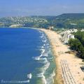
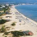
Saaremaa beaches
The island has many beaches, mostly pebbly or rocky. In the town of Kuressaare there is an equipped sandy beach.
Officially, the swimming season on Saaremaa lasts all summer months.
Last changes: 12/26/2012Treatment on the island of Saaremaa
In 1820, it was discovered that the local sea mud has medicinal properties... The first mud baths was built in Kuressaare in 1840, and now the capital of the island is literally crammed with all kinds of mud baths and spa centers, where lovers of water and wellness sessions can enjoy hundreds of different procedures.
Soft maritime climate and healing mud, picturesque nature and a leisurely lifestyle local residents promote relaxation and wellness.
Last changes: 12/26/2012Sightseeing in Saaremaa

Maasi Castle (Maasilinn) located near the second largest city on the island - Orissaare. It was built by the master of the Livonian Order in 1345, but after the transfer of land to the possession of Denmark, it was destroyed. Now it is picturesque ruins, but soon they intend to reconstruct the castle. Most of the dungeons have survived, where tourists are allowed to enter.

Windmills (Angla tuulikud)- it business card Saaremaa. They can be admired in the village of Angla, which is located north of Kuressaare. To date, out of the five presented to the review, only one mill is in operation.

Popular attraction of extraterrestrial origin - Kali meteorite crater (Kaali kraater)... It was formed about 4,000 years ago, 18 km from the capital of the island. The crater is surrounded by a 16-meter earthen rampart. There are 8 other smaller craters in the area.

In the western part of the island is located national park(Vilsandi rahvuspark) Is another popular tourist destination. In this protected part of the island, you can see old pine and heather forests, alder and lingonberry bogs. The fauna of the reserve is also rich - about 30 species of mammals and more than 200 species of birds live here, for observation of which there are several equipped sites. Also on the coast national park you can see gray seals.

Pagan Cliff (Panga Pank)- not only the highest cliff on the north coast of the island. He received his gloomy fame in ancient times. It was from this coastal ledge that the pagans dropped the sacrifices intended for the god of the sea.
How to get to Saaremaa island
The connection between the mainland and the island of Saaremaa is via the neighboring island, where the port of Virtsu is located, to which there is a ferry from the mainland port of Kuivastu. Saaremaa is connected to Muhu by a dam, which can be reached by bus or car.
The easiest way to get to Saaremaa from is by bus: the ferry crossing is included in the ticket price, so even on summer weekends you can avoid queues for the ferry, which are not rare at this time.
B has its own international Airport- Kuressaare Airport, which accepts flights from airlines to and from Tallinn.
In cold winters, an ice road is built between Saaremaa and the mainland, along which the island can be reached by car.
Last changes: 12/26/2012And half a thousand small and insignificant ones.
The main and largest in terms of area is Saaremaa, an island that in former times bore the German name Ezel. The dam connects it with, from where the port of Virtsu on the mainland is easily accessible by ferry.

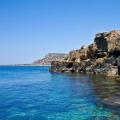
The coastline of Saaremaa is very indented and its length exceeds 1,300 kilometers. These are mainly rocky beaches with cozy secluded bays, where it is so pleasant to spend weekends under the cool Baltic sun.

The climate in Saaremaa is very mild and allows you to enjoy nature at any time of the year. Summer here is long and very warm, and in winter the temperature does not drop below -4 degrees.

The main attractions of Saaremaa can be divided into two categories: natural and man-made. Both are so unique, inimitable and individual that they cost not only an air ticket to, but also a full vacation or vacation spent here.

Nature is the main temple
If you've become the destination of your travel or vacation trip, Saaremaa is a place that should not be ignored. It is here that the sights are concentrated, without which the idea of the country will not be complete.
The mild climate allows dozens of plant species to exist on the Estonian islands, most of which are under state protection due to their uniqueness. In summer, the local bogs are covered with a soft carpet of yellow rattle bells, which only grows in Saaremaa.

The island also pleases fans of orchids growing on its lands in countless quantities.

The coastal waters are home to rare species of seals, and birdwatching on the islands of the Moonsund Archipelago is a great way to get genuine pleasure from nature.

The most "birdlike" is the small islet of Abruka, where flocks of migratory birds stop in spring and autumn. Abruka is part of a conservation area that even deer consider their home.

"House of Light" and traces of aliens
It would seem that it can offer tourists besides medieval architecture and rocky beaches? Saaremaa Island refutes stereotypes and invites you to get acquainted ... with the traces of aliens. Well, let the experts call the falling meteorite the cause of the occurrence with absolutely even edges, the real fans of the hypothesis of the existence extraterrestrial civilizations will find their explanation for the Estonian phenomenon. The crater is about a hundred meters in diameter and may well be the landing site of an interplanetary spacecraft thousands of years ago.

Excellent photos of another attraction of Saaremaa are obtained on the Sõrve Peninsula. The local lighthouse rises almost fifty meters above the bay, and its venerable age is approaching four centuries!

Sõrve lighthouse took part in World War II and was even wounded in battle.

"With wings, but not flying ..."
The Estonian islands are ready to give two answers to this children's riddle. Moreover, one of them can run away, and the second - to inspire some associations with tulip Holland. Firstly, it is open, the inhabitants of which have not learned to fly, but they always do not mind accepting a treat from the hands of travelers. Children are delighted with interacting with huge birds, and their parents are delighted with the gift shop on the territory of the farm.

The second representative of the "flightless, but with wings" family is windmill, of which there are five in Saaremaa. In addition to great photographs on the hill with windmills, here you can get a souvenir of bread made with your own hands, a felt toy or an earthen pot. Tourists can try their hand at any of the crafts presented here.

Metropolitan life
Saaremaa County Center and main city the island is small even by Estonian standards. It is home to no more than 15 thousand people, but the sea harbor and airport make it popular tourist center not only, but throughout the Baltics.

For the first time the city was mentioned in the chronicles of the late XIV century as a settlement of monks on the island. Then they sold it to Denmark, then Sweden, which, no doubt, left a deep mark on its historical appearance.

During the Great Patriotic War, battles took place, and today a memorial to Soviet soldiers has been erected here.
The main architectural and historical sights of the center of Saaremaa county are called and. - not only one of the most ancient in the Baltics, but also perfectly preserved to this day. Since the 13th century, its mighty bastions have seen many military battles, and the legends about mysterious towers and dark dungeons tickle the nerves of today's guests of the fortress. The modern museum tells about the history of the city, and craft workshops introduce you to traditional folk crafts.

The austere and majestic city was built in the 17th century by order of a Swedish aristocrat. Its main value is the largest ceiling painting in. The medieval spirit of the stone walls lends a special charm to dinners in the local restaurant, after which it is so pleasant to wander through the halls of the gallery and admire the work of local artists.

On the seashore in Kuressaare there is another famous place on Saaremaa. The monument to the famous giant named becomes an indispensable object of photo sessions for all guests of the island. The heroes of Estonian folk tales and legends, embodied by the sculptor in bronze, return from a successful fishing trip, and their three-meter figures are clearly visible even in the morning Baltic fog.
 Walking around the city will certainly bring guests to the park, founded in the middle of the 19th century. There is a monument that presents the history of the park, and rare plant species and magnificent examples of landscape design put the green oasis of Kuressaare on a par with the most famous parks in the world. In summer, the park becomes open area for concerts and performances, and on short winter days it enables the townspeople to perform pleasant walks in the fresh air.

The islands are a great way to spend your vacation and see the unobtrusive but memorable beauty of the Baltic nature, whose charm is impossible to tell.

There are many mini-hotels and guest houses where you can comfortably stay. The hotels are equipped with all the benefits of civilization, but at the same time they retain a sense of simplicity and privacy.

Enjoy communication with the sea and the dunes, admire the flowering meadows and breathe in the life-giving aroma of the air infused with pine needles - this is how the islands allow you to feel like a part of wildlife lovingly preserved by many generations of local residents. The artists here are best at watercolors, and poets - white verses. As bright and light as summer nights on Estonian islands large and small.

goBaltia