Depending on whether karsting rocks come out on the earth's surface, or they are overlain by non-karsting sediments from above, a distinction is made between naked and closed(covered) karst. Naked karst is most often characteristic of mountainous areas, where denudation processes are most intensive, closed karst - of plains. Greatest variety landforms and the greatest activity of karst processes are usually characteristic of bare karst.
Rain or melt water, flowing down the surface of the limestone, corrodes the walls of the cracks. The result is a microrelief carrow or shrattov- a system of ridges and ridges or furrows separating them. Furrows and ridges are located approximately parallel to each other, if the fall of the layers is clearly expressed and the fracturing of the rocks coincides with the direction of the fall. In a more complex system of fracturing, the karrs are located completely incorrectly, intersect, branch and merge again. The depth of the furrows can be up to 2.0 m.
Carr-covered spaces are called carr fields. As the cracks widen, the crests become narrower, break and break apart into separate fragments. Such old karr fields are often chaotic heaps of large and small fragments of limestone with here and there preserved and protruding over these heaps of karr ridges.
Karrs can also form in the coastal zone when the sea surf affects the karst rocks.
When limestones dissolve, an insoluble part always remains, represented by a red or brick-colored clay material. This eluvial material, accumulating on the surface of rocks, forms a kind of weathering crust characteristic of karst areas, the so-called terra-rossa (red earth). With a significant accumulation in the cracks, the clayey material of terra-ross can completely clog them, and then the process of carro-formation stops. Therefore, fracturing is one of the main conditions for carro formation,
With intensive vertical water circulation, the dissolution of karst rocks leads to the formation ponor- channels absorbing surface waters and taking them deep into the karst massif. The size and shape of ponor are varied and depend on the degree of their development. On the surface, the ponors are expressed by gaping cracks or holes; in the depths, they begin a complex system of vertical water circulation channels.
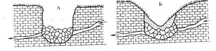
Expansion of the ponor orifices in the process of further dissolution leads to the formation sinkholes of various sizes and shapes depending on age, type of karst rocks and their occurrence: from slit and well-like to saucer-like (Fig. 73).
Rice. 73. Types of karst negative landforms: A - saucer-shaped depression of suction; B- suction funnel; B - karst well of failed origin: / - non-karst rocks; 2-karsting rocks
In closed karst, funnels are formed not only due to dissolution, but also as a result of mechanical removal - suffusion- into ponores of insoluble rocks lying from the surface. Such funnels are called karst-suffusion or suction funnels. Karst saucers, funnels and shallow wells in Western European literature are called valleys.
Karst landforms can be randomly scattered 110 on the surface of a karst massif or concentrated along certain lines due to the direction of groundwater flow or occurrence of karst rocks. These forms are not "frozen". They can go one into the other. So, a karst saucer as a result of deepening, and a karst well as a result of flattening of the slopes can turn into a karst sinkhole (Fig. 74).
Rice. 74. Transformation of a well-shaped depression (.4) into a funnel-shaped depression (5) (according to I.S.Schukin)
If the walls of the ponor continue to dissolve, then the channel becomes large enough and turns into natural well or natural mine. Karst mines and wells often reach very great depths (several tens or hundreds of meters). One of such mines in northern Italy, in the vicinity of Verona, reaches a depth of 637 m. The general direction of the mines is close to vertical, but there are significant deviations, some sections of the mines can be almost horizontal or inclined. Shafts are often laid at the intersection of several fracture systems. With further dissolution of the walls, the mines can turn into fairly wide underground passages into caves.
Natural wells are often called forms such as natural mines, but smaller. Some researchers assign the term "well" to certain forms, which are formed not due to surface leaching, but by the collapse of the vault over the underground cavity. In such cases, negative forms of a cylindrical relief appear, with vertical walls and a bottom cluttered with debris. Often such wells are arranged in rows, as if marking on the surface the direction of the underground galleries, over which they are formed.
Failure, or superficial, funnels, merging, form ". blind ravines or forms of rather bizarre outlines, called "Uvala". Known, for example, slopes up to 700 m in diameter at depths of up to 30 m. Such formations are, as it were, transitional forms to even larger karst baths - polish.
Polya - extensive, usually flat-bottomed and steep-walled karst depressions several kilometers, and in some cases several tens of kilometers across. Popova polya area in western Herzegovina (Yugoslavia) reaches, for example, 180 km 2. On the flat bottom of the field, a stream sometimes flows, which in most cases appears from one wall of the field and hides in an underground gallery in the opposite wall.
The origin of the fields is not always clear. Apparently, they are formed in different ways. Some researchers believe that poly is one of the later stages of development. karst relief formed by the confluence of many sinkholes and karst basins. At the same time, if in the course of the development of the karst process the basis of karst denudation is reached - the level of groundwater, the further development of such a form will be possible only due to the retreat of the walls, i.e. growth in width, which leads to the formation of a polish. However, polya with a dry bottom, and even with numerous karst forms, either confined to the surface of the bottom, or buried under the products of weathering, are quite common.
In all likelihood, there are at least four different cases of the formation of fields. First of all, there is a polish of tectonic origin - grabens or troughs, which receive the features of karst formations with all their characteristic morphological and hydrogeological features inherent in karst. As a rule, these are the largest polia. An example of such a field is the already mentioned Popovo field in Yugoslavia. Often, non-karsting rocks also take part in the structure of the tectonic field.
Polya can be formed due to erosion and removal of products of erosion of insoluble rocks lying among soluble limestones. In this case, the size of the polish is determined by the mass of the insoluble rock, the shape of its occurrence. The walls of such a polish are prepared contacts between the insoluble rock and limestone. According to N.L. Gvozdetsky, such an origin has, for example, the Shaorskoye Pole in Western Georgia.
The third way of polye formation has already been mentioned - this is the formation of a large karst basin due to the merger of smaller negative landforms. The outlines of such fields are usually very jagged.
Finally, a polya can be formed by a sinkhole over an underground river valley. The possibility of such an origin of the fields is evidenced by the presence of such peculiar forms of relief as natural bridges - the remains of the collapsed vault of the underground
galleries connecting two opposite slopes of the polya. Such, for example, is the origin of the Rakbakh polya in the western part of Yugoslavia. A river flows along the bottom of this field, which appears on one side of the field and goes back into the underground cavity in the opposite part of the field.
G. Lun, who explored the karst in the Western Taurus (Turkey), came to the conclusion that the plains of the Western Taurus were originally river valleys, but the development of the karst process led to the disappearance of rivers. Further expansion of abandoned valleys II, their transformation into polya, is associated with the correlating effect on the walls of the basins of temporarily flooding them. The accumulation of waterproof weathering products at the bottom of the fields, firstly, contributes to the retention of temporary waters, and secondly, prevents the further development of the karst inland.
Karst called the phenomena that occur in soluble rocks (limestone, dolomite, gypsum, less often salt, chalk) under the combined action of surface and mainly groundwater. The phenomena of karst formation lead to the emergence of special forms of relief: carrs, sinkholes, wells, mines, karst hollows, plains, etc.
Educational conditions karst forms: 1) the presence of soluble rocks; 2) the presence of cracks that make these rocks permeable; 3) a slight slope of the surface, allowing water not only to drain, but also to seep; 4) significant thickness of karst rocks; 5) their elevated position or low position of the groundwater level, providing vertical circulation of water in the rocks; 6). sufficient, but not excessive, amount of water.
When karst rocks are on the surface, the karst is called open (Mediterranean); if these rocks are covered by other “non-karsting rocks, karst is called covered(Central European).
Carr(shratty) - deep grooves on the exposed surface of karst rocks, separated by narrow, often sharp ridges. Carrs are arranged in rows parallel to each other, or represent complex branching labyrinths. The depth of the karr ranges from a few centimeters to 2 m.
The formation of this form of karst relief is caused by the chemical and mechanical effect of rainwater, melting snow, the sea (in the surf) on the surface of soluble rocks. Dissolution proceeds intensively in depressions through which water flows.
The shape and size of the carriages depends on chemical composition and the nature of rock fracturing, as well as the climate. Carr is best expressed in clean limestones in dry subtropics. Under these conditions, furrows and ridges are more or less symmetrical and have approximately the same size.
Carr clusters form difficult-to-pass karry fields... Over time, the surface covered with karrs changes: cracks widen, ridges collapse, heaps of limestone blocks appear, which are very typical for areas of developed open karst. Karr surfaces are almost always devoid of vegetation.
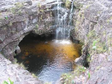
Karst sinkholes characteristic of both open and covered karst (Fig. 109). This is the most typical and widespread form of karst relief. There are funnels of surface dissolution and sinkholes, as well as funnels of "suction".
Surface dissolution funnels are formed in areas of open karst as a result of dissolution of the walls of cracks that cut the surface. They are saucer-shaped and conical in shape. Saucer-like surface depressions occur when the walls of numerous small cracks dissolve. When the walls of a deep crack dissolve, a cone-shaped funnel with a slope steepness of 30-45 ° is formed. At the bottom of such a funnel there is a ponor - a hole through which water flows down into it.
Sinkhole funnels- the result of roof collapse underground caves- have steep, steep slopes, at the bottom - a pile of blocks of collapsed rocks. Over time, if the collapse stops, the slopes of the funnel become more gentle.
Funnels "suction" common in the area of covered karst. They are formed when the sandy-clay particles from the surface insoluble rocks are washed out by the water flowing into the ponor. If the leached particles clog the ponor, the growth of the funnel slows down or stops altogether. Externally, seepage funnels resemble cone-shaped dissolution funnels. Their slopes are usually covered with vegetation.
When the ponor is blocked or the water table rises, karst sinkholes can become a place of accumulation of water and turn into temporary or permanent karst lakes.
With the expansion of large cracks in karst rocks, karst wells and mines appear.
Karst wells- depressions of cylindrical shape, reaching depths of tens of meters. The width of a karst well is usually no less than its depth. They are formed as a result of the collapse of the arches of the underground cavity.
Natural mines look like a pipe with bends and extensions descending to a great depth from the surface (the deepest karst mine near Trieste is 523 m). Rivers can disappear in karst wells and mines.
Extensive closed basins found in karst areas are called polyev... The polya covers an area of up to several hundred square kilometers (for example, the Lebanese polje in Western Bosnia is 379 square kilometers). The flat bottom of the fields is limited by ledges several hundred meters high. At the bottom, lined with sediments, limestone mountains can rise - outliers, rivers flow. When flooded with water, the fields turn into permanent or temporary lakes.
The formation of pools can be caused not only by the process of karst formation, but also by tectonic processes, as well as the removal of insoluble rocks that occur among limestones.
River valleys in karst areas, they usually result from the collapse of tunnel vaults over underground rivers. They can be classified as canyons. In some places, when the vaults collapse, karst bridges appear.
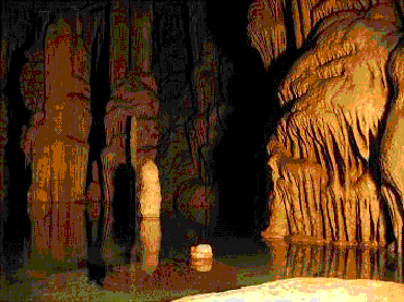
In karst rocks, along with special forms of surface relief, various underground cavities are created - caves... They arise mainly in the strata of limestone, gypsum and rock salt as a result of the expansion of cracks under the action of groundwater. Growing caves often have streams and lakes. When groundwater goes down through cracks, caves dry up and stop growing. If water seeps into a cave from above, droplets of which evaporate from the ceiling and floor of the cave, drip formations of carbonic lime appear, gradually filling the cave. Stalactites hang from the ceiling in the form of giant icicles, and stalagmites rise from the floor towards them. When they meet, they merge into columns. In the humid air of a cave (with a river or lake), drip formations are not created.
Karst caves reach especially large sizes in thick limestone strata, deformed by tectonics.
The largest of all known caves is the Hellock Cave (Switzerland, Alps). Its length (without side branches) is 78 km. Mammoth Cave has a length of 74 km, without branches - 48 km. In Russia, the Kungurskaya cave is interesting. It is formed in gypsum, lying among layers of limestone and dolomite. The complex labyrinth of the most branching studied galleries of the cave stretches for 4-5 km. The cave has several floors. At the bottom of the cave there are more than 30 lakes of various sizes. The area of the largest of them is about 200 sq. m, depth - 4-6 m. Kungurskaya cave belongs to the type of cold (ice) caves.
The air of cold (ice) caves has all year round low temperature due to the fact that it communicates with the outside air through an opening (entrance) located in the upper part of the cave. In winter, cold, heavy air fills the cave, in summer it stays in it and does not have time to warm up. Moisture trapped in the cave freezes, forming ice.
In contrast to the cold caves in the warm caves, the entrance is located at the bottom. The cold air that fills the cave in winter flows out of it in summer, giving way to the rising warm air. In such caves, archaeologists often find the remains of the sites of ancient people.
Caves with two entrances - upper and lower - are called through (wind). The air temperature inside such caves is close to the outside air temperature.
Stages of development of karst relief. At the initial stage of the development of karst relief (young karst), groundwater is deep. Rocks on the surface are almost free of cracks and poorly permeable to water. There are surface streams. Karr appears on the surface of the exposed karst, craters and wells appear. As the cracks expand and increase in number, seepage increases, but some of the water still remains on the surface.
The leaked water accumulates above the waterproof layer (the layer can be waterproof temporarily, until it is dissected by cracks), forming separate streams.
At the stage of maturity, the karsting process goes from below and from above. Dips appear on the surface, funnels merge into hollows, and a spill appears. Almost all water from the surface goes down the cracks, vertical circulation of water leads to the emergence of caves. Ground water form a continuous network of streams.
In the stage of old age, the forms of karst relief lose their definiteness; the funnels flatten, the fields expand, hardly soluble weathering products accumulate on the surface, clogging the ponores. The destroyed surface is reduced to the level of groundwater, therefore, the vertical circulation of water is replaced by a horizontal one, and a normal river network is developed. Rivers flow slowly, swamps are formed. The rise in the surface or the lowering of the groundwater level can revive the processes of karst formation and renew the relief.
Karst phenomena are primarily due to the presence of soluble rocks, therefore, they occur at different latitudes. Soluble rocks occupy about 34% of the land surface, and even if we take into account that the karst relief is far from being developed throughout this area, its wide distribution is beyond doubt. Karst relief is widely developed along the coast of the Adriatic Sea (from the Karst plateau to Greece), in the Alps, in the Crimea, on the Black Sea coast of the Caucasus, in the Urals, in the Onega region, in many regions of Siberia and Central Asia, in Jamaica, in the territory North America(states of Kentucky and Tennessee, in Northern Yucatan, in the interior of Florida), in China, Australia, etc.
Karst regions are distinguished not only by a special relief, they are characterized by a general uniqueness of physical and geographical conditions associated primarily with a special regime of waters.
The ruggedness of the karst regions, the poverty of the surface with water make these regions unsuitable for economic use.
FEDERAL AGENCY FOR EDUCATION GOU VPO Saratov State University named after N.G. Chernyshevsky "
Department of General Geology and Mineral Resources.
COURSE WORK
Karst and karst sediments
Completed: student
1 course, geol. fact,
Group No. 151, day department
Sokolov Egor Semyonovich
Supervisor:
assistant Yampolskaya O.B.
annotation
The work is devoted to issues related to karst and karst sediments. The concept of karst is revealed in it. The main forms of karst relief, the factors of formation, the reasons for the accumulation of mineral substances and their sources are described. The classification and methods of karst research are stated. Mineral resources of the karst facies are considered.
Introduction
Chapter 1. General information
1.1 The concept of karst
1.2 Karst forms
1.3 Classification of karst and the question of its zoning
1.4 Technique of karst research
Chapter 2. Factors of karst formation
2.2 Rock structure
2.3 Fracturing of rocks
2.4 Tectonic structures and thickness of karst rocks
2.5 Covering formations and topography
2.6 The steepness of the slope of the topographic surface
2.7 Gravity
2.8 Underground rivers
Chapter 3. Reasons for the accumulation of minerals in karst facies
Chapter 4. Sources of karst sediment matter
Chapter 5 Mineral Resources of the Karst Facial Area
5.1 Types of minerals
5.2 Ore minerals
5.3 Non-metallic minerals
Conclusion
Bibliography
Introduction
The topic of this course work is karst. I believe that every geologist should know about karst, since different scientific directions are developing in the doctrine of karst (karst science). The most widely represented are geographic and geomorphological. At the same time, karst is the result of certain transformations of rocks. In the course of them, the destruction of rock-forming minerals, the transportation of substances and the accumulation of new formations are carried out. Consequently, in the theory of karst there is a range of problems solved by geological sciences. Discussion of these problems on the basis of extensive factual material is of scientific and practical interest. Karst also significantly affects the landscape features of the territory, its relief, runoff, groundwater, rivers and lakes, soil and vegetation cover, and economic activities of the population. In the karst areas, there are fabulous underground palaces-caves richly decorated with nature.
Expand the concept of karst
Give a description of the main underground and surface karst landforms
To characterize the factors influencing the development of the karst process and the formation of karst landforms
Find the reasons for the accumulation of minerals in karst forms.
Explore the sources of material in karst sediments
Describe the minerals of the karst facies area
Chapter 1 General Information
1.1 The concept of karst
The karst process is a long-term process of dissolution and leaching of fractured soluble rocks by groundwater and surface waters. As a result of the activity of karst processes, both negative forms of relief appear on the earth's surface, and various cavities, channels of grottoes or caves at a depth. The term "karst" comes from the distorted Austrian name of the Karst plateau in Slovenia, on which these phenomena are pronounced and well studied by European researchers. Karst phenomena are extremely widespread. According to geological conditions, approximately one third of the land area of the globe has potential for their development.
There are several conditions necessary for the development of karst phenomena.
Firstly, it is the presence of rock soluble in natural waters, permeable due to fracturing or porosity.
Secondly, the presence of a solvent, i.e. water aggressive to the rock.
Thirdly, the presence of conditions that ensure water exchange - the outflow of water saturated with a dissolved substance and a constant inflow of fresh solvent. If the first condition is determined by the geological structure of the area, then the second and partly the third is closely related to the physical and geographical situation, the second with the soil and vegetation cover and climate, and the third with geomorphological and hydrological conditions in addition to the geological structure and hydrogeological features.
Typically karsting rocks are mono- and bimineral rocks - rock salt, gypsum, anhydrite, chalk, limestone, dolomite, islamic - dolomite rocks, varieties of marble, magnolite, carbonatite. The leading role in this list is played by carbonate rocks, both due to their wide distribution (about 15% of the land area) and due to the contrast in compositions between them and loose sediments, which causes side interactions leading to further karstification.
The concept of dissolution (solubility) refers to chemical compounds, including minerals. There are two types of dissolution of a substance - congruent, when all its components are transferred into a solution, and the reaction is reversible, and incongruent, when not all components of the substance pass into the solution. In this case, a solid phase remains and the reaction is irreversible. Both types of dissolution are manifested in the hypergenesis zone, but congruent dissolution is characteristic of karstification, and incongruent dissolution is characteristic of crust formation and leaching metasomatism.
Distinguish between open, or bare karst, when soluble rocks emerge on the day surface, and closed, when they lie deep underground and are covered from the surface by strata of insoluble rocks.
Surface karst forms include kars, ponors, karst niches, sinkholes, hollows and fields, as well as wells and abysses.
Underground karst forms are represented by caves and channels.
Karst processes create not only certain forms of relief, but also take part in the formation of peculiar deposits. On the surface and at the bottom of karst landforms, residual formations from dissolution are located - this is a carbonate-free, mainly aluminosilicate material remaining after dissolution. It is called terra-rossa (red earth). On the surface and in caves there are landslide accumulations - products of the collapse of the vaults of karst cavities or from rolling down the slopes karst valleys and funnels of lumps. The caves contain peculiar alluvial sediments formed by underground rivers. There are also travertines - sintered forms of calcareous tuff, as well as original sinter forms - stalactites, growing from the roof of the cave downwards. Their delicate weaves are often called stalactite curtains. Stalagmites grow up from the bottom of the caves.
1.2 Karst forms
Landforms formed as a result of the karst process are divided into surface and underground.
1 surface forms of karst
Surface karst forms include carry, troughs and ditches, craters, saucers and depressions, hollows, polya, outliers.
According to their genetic origin, carrs should be distinguished into forms that have arisen on the bare surface of a soluble rock, and forms that have formed under the soil-vegetation cover with its subsequent removal. Cars of the second type are found in many countries of the world.
Morphologically, carrs are subdivided into grooved, wall, hole, tubular (in the form of tubular cylindrical depressions in gypsum) stone stones, carry in the form of traces, grooved, meander, and fissured. Another type has been identified - structural karrs; on a steep limestone slope, karr depressions have been developed in chemically relatively pure limestone, separated by narrow ridges that correspond to highly siliceous interlayers.
By genesis, grooved and fissure carriages are especially distinguished. Grooved carrs are formed under the influence of only atmospheric precipitation, as a result of the first three phases of limestone dissolution, without the participation of the fourth phase, while the other types of carrs are formed under the action of all dissolution phases: waters enriched with biogenic carbon dioxide due to the contact of atmospheric precipitation and melt water with soil and vegetation cover.
(Figure 1) flute carr
Fissure karrs differ from the rest in ways of removing solute. While in most other types of karrs it is carried out by surface runoff, then during the formation of fissure karrs, the removal of dissolved matter by underground means, through cracks, is also involved.
Karst trenches and ditches (deeper and always with steep sides) develop along open tectonic cracks (often as a result of unloading on steep slopes) or along slope subsidence cracks, or “side-push” cracks. They stretch for tens and hundreds of meters, and sometimes for several kilometers, reaching various widths and depths. At the ends they are closed, at the bottom they can have numerous depressions. Straight ditches in limestones, developed along vertical tectonic cracks, 2 ~ 4 m wide and up to 5 m deep in Yugoslavia are called bogazi.
Among karst sinkholes, there are three main genetic types:
Surface leaching funnels, or purely corrosive. They are formed due to the removal of rock leached on the surface through underground channels in a dissolved state.
Failure funnels, or gravity. Formed by the collapse of the vault of an underground cavity, which arose due to the leaching of karst rocks at depth and the removal of matter in a dissolved state
Suction funnels, or corrosive suffusion. They are formed by washing and subsidence of loose cover sediments into wells and cavities of a karst basement, removal of particles into underground channels and removal through them in a turbid and suspended state.
(Figure 2) karst sinkhole.
Saucers, depressions are indistinctly defined small funnels.
Basins. Funnels of all genetic types, merging with their edges, form double, triple and more complex baths and basins. There are two main types of basins - complex ones, which are formed when several large funnels merge and have depressions at the bottom, and flat-bottomed basins. The following genetic types of basins are distinguished: surface leaching, sinkhole, suction, and also created in combination with other processes, for example, erosion. Large basins of surface leaching are often formed due to the corrosive action of melt water, snow and firn patches. Many of these basins are a legacy of the periglacial conditions of the last ice age.
The Polje is a vast closed depression with steep sides, with a flat bottom, which has reached a temporary or permanent maximum level of karst, with karst-type hydrography.
Polye arises as a result of the development and connection of karst basins formed from merged sinkholes.
Polya by its origin, until recently, was divided into: 1) tectonic, 2) arising by underground mechanical removal of insoluble rock, lying among karst limestones or in contact with them, 3) formed by the merger of a group of adjacent craters and hollows (ridge) during their growth in the horizontal direction, 4) failures.
Large basins of purely tectonic origin (grabens, synclinal troughs) cannot be considered polys. With the formation of glades, leaching and removal of the dissolved substance through underground channels are required. Therefore, the first group should include tectonic-corrosion and tectonic-corrosion-erosion. This group includes the Polish Yugoslavia. Glades of the third type are usually small, of irregular lobed shape in plan. They are characteristic not only for carbonate, but also for gypsum karst, they are found even in platform conditions.
Remnant karst is a mature stage of dissection of an uplifted flat-topped limestone massif. The steepness of the slopes of the outliers is due to the vertical fracturing of limestones and the weakening of the slope runoff due to their permeability. Of great importance is the crumbling of limestone along the cracks due to the erosion of the outliers from below by waters that flood the plains at their base, or by groundwater lying at the base surface. Because of this, at the base of the remnants, corrosion niches developing in the horizontal direction arise. The undermining of outliers from below by lateral corrosion of surface waters is facilitated by the accumulation of waterproof sedimentary clays on the base surface. The distribution of relict remnant karst is consistent with the displacement of the equator during the geological history of the Earth. Since in low latitudes the humid-tropical climatic situation has already existed for more than one geological period, the remnant karst widespread there can be considered not only modern, but also ancient.
The transition from surface forms to grotto-type caves is represented by awnings and niches. Often they are interesting from an archaeological point of view. Often these are surface formations that have arisen due to more intensive leaching of individual layers or layers of layers by waters flowing down the cliff, with a high value of biochemical weathering (under the action of lower plants settling on periodically moistened surfaces). In river valleys and on the shores of the seas, river and sea waters play the main role in surface leaching. On the seashore, the dissolving effect of sea water is combined with abrasion.
In the process of the formation of deeper niches, corrosion due to water seeping through cracks in the rock, and, in addition, the collapse of rock blocks due to the expansion of cracks due to leaching of their planes, acquire significant importance.
In limestone niches of subtropical and tropical regions, drip-drip formations are found. Stalactites merge to form curtains and draperies.
Natural bridges and arches most often occur when the ceiling of cave tunnels, and sometimes niches, collapses.
1.2.2 underground karst forms
Among the underground karst forms, one can distinguish karst wells and mines, abysses and caves.
Karst wells and shafts are vertical or steeply inclined abysses that differ in depth; mines include abysses deeper than 20 meters, reaching several tens, or even hundreds of meters. The cavities of wells and mines can be failure (gravitational), gravitational-corrosive, formed by leaching karst rock with water along cracks and partial collapses; nival-corrosive, resulting from the corrosive action (along cracks) of melted snow water; corrosion-erosional, which are formed by water streams rushing down the cracks, producing erosion, prepared by dissolution along the adhesions of rock grains; formed by a similar action of artesian waters ascending along the cracks.
Karst chasms are combinations of natural mines with horizontal and inclined cave passages. These include, in particular, the deepest karst abysses in the world, reaching depths of 1000 meters or more.
The largest underground forms of karst relief are karst caves. They represent a system of horizontal or several inclined channels, tunnels, complexly branching and forming huge halls or grotto, having a height of several tens of meters. The caves can be connected with each other by tunnels, gaps or narrow crevices. Underground rivers often flow through the canals, and underground lakes are located at the bottom of the caves. The undergrounds of the river not only leach the rocks in contact with them, but also produce a great erosive effect.
Majority karst caves formed with the leading role of leaching, often with the combined action of dissolution and erosion of rocks (erosion, prepared by dissolution along grain adhesions). The role of rock collapse is also significant, especially at the mature stages of the development of cave cavities. Some of the caves were created under the influence of thermal and mineral waters. Cave cavities of the so-called "ore karst" developed under the influence of sulfuric acid solutions on limestone, formed during the oxidation of pyrite and other sulfides. There are caves, which are basically very open tectonic cracks, but modeled by the processes of leaching (underground karr, etc.) and sedimentation along the walls of cracks of drip-and-drop formations.
(Figure 3) Flow formations in Katerloch Cave, Austria.
Cave cavities can develop in the aeration zone, i.e. in the zone of vertical circulation of infiltrating waters. However, large karst caves originated mainly when the cave channels were completely filled with groundwater, in the zone of complete saturation, and the water in them circulated under hydrostatic pressure. There are a number of stages of their development, related to the epochs of full and partial filling with water - the pressurized epoch and the non-pressurized one. Based on the processing of G.A. Maksimovich L.I. Maruashvili singled out seven stages: three - in the pressure era of evolution (fissure, crevice, channel) and four in free-flow (vockluz, water-gallery, dry-gallery, grotto-chamber).
With the ascending development of the earth's crust in conditions of high thickness of limestone strata and folded structure, multi-storey systems of cave galleries arise
Significant multi-storey cave systems are known. Paleozoological and archaeological data indicate an older age of the upper floors in comparison with the lower ones, indicating some analogy in the development of caves and terraced levels of river valleys.
In the morphology of cave cavities, fracturing of karst rocks and drip formations play an important role. When developing cave tunnels along vertical and steeply inclined cracks, they are distinguished by their straightness and sharp "elbow" bends. Branches branch off from them under different slopes. Tunnels often intersect, forming complex lattice labyrinths. The evolution of drip-and-drip formations depends on a decrease in water inflows into the cave during the transition from the vocluse to the water-gallery and dry-gallery stages. At first, the influxes on the floor of the cave, gurus develop, then stalagmites with a wide base, which are replaced further by stick-like ones. And only when the inflow of water decreases to 0.1 - 0.01 cubic meters. cm per second, stalactites appear. With a general decrease in the water content of the cave in the course of its evolution, at the same stage, unequal inflows of water are observed in different parts of the cave cavity, which is why different forms of drip formations appear.
Glacier caves are characterized by icy drip and crystalline formations. Seven types of karst glacier cavities have been identified, differing in the conditions for the occurrence of cave cold, accumulation of snow and ice. Three types belong to the area of permafrost, where the cave ice represents its special form.
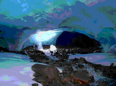
(Figure 4) Ice cave at the edge of the Fall Glacier, Svalbard.
1.3 Classification of karst and the question of its zoning
At the international speleological conference in Brno (1964), a classification of the USSR karst was proposed, based on the combination of six morphological-genetic and five lithological types. Now this classification has been supplemented and here it will also be said about the types of karst that are not found on the territory of the former USSR, but are known in other countries, mainly in tropical latitudes.
The identified morphological and genetic types differ significantly from each other morphologically and genetically by different surface and sometimes underground karst forms and their combinations. Lithological differences are taken into account already in the selection of types, because different solubility of rocks, the rate of dissolution and the rate of saturation of the solvent, differences in the processes of dissolution of carbonate and non-carbonate rocks, their different changes from temperature, and therefore climatic conditions - all this affects the development of karst , its morphology and engineering-geological assessment.
The types of karst obtained by combining morphological-genetic and lithological classifications are grouped into two classes of plain and mountain karst (with subclasses of low-mountain, mid-mountain and high-mountain).
MM. Sweeting identifies four main types of karst:
real karst (holokarst);
fluviokarst;
glacial-nival karst, including permafrost karst;
arid and semi-arid karst (the latter type is considered in the chapter on tropical karst and is characterized only by the features of its tropical and subtropical variants).
Outlines of such a general geographic classification were given earlier, however, it seems that the general geographic types of karst identified by Sweeting are too wide, each of them includes several types of a more detailed classification of Gvozdetsky, taking into account not only the general physical and geographical setting of karst development, but also the nature and thickness of the cover over karst rocks (the identification of one type of fluviokarst does not give this) and very important lithological features.
Gvozdetsky identified the following morphological and genetic types of karst: 1) buried or fossil karst; 2) armored karst; 3) covered karst; 4) soddy karst; 5) semi-turf and partially turf karst; 6) naked karst; 7) remnant tropical karst (on the territory of the former USSR only relic karst); 8) karst developing in permafrost conditions; 9) marine karst.
The main lithological types, with which morphological and genetic ones are combined, are as follows: 1) limestone karst; 2) dolomite karst; 3) karst in marbles; 4) chalk karst, including in chalk-like marls; 5) gypsum-anhydrite karst; 6) salt karst.
The types of karst obtained by combining both classifications are named as follows: bare limestone karst, covered with gypsum-anhydrite karst, buried chalk karst, and such types can be attributed to the plain or mountain class.
All morphological and genetic types of karst identified on the territory of the USSR are also found in other countries. For example, karst, combined with permafrost, is developed in Svalbard, Canada.
Ostantsovy tropical karst is modern, although quite ancient at the beginning of its formation, developed in tropical latitudes. It is represented by several subtypes: tower, conical and domed karst. Tower (with flat-topped steep outcrops) and conical karst are often called international terms borrowed from the German language - "turmkarst" and "kegelkarst". Sometimes outliers rise among the marginal plains, in other cases they are not associated with them and then are combined with numerous depressions.
In tropical latitudes, morphological and genetic types are also widespread, analogs of which are also found in the karst of temperate latitudes. A special morphological and genetic type of tropical karst should include the karst of coral reefs raised above the level of the ocean surf.
A peculiar variant of bare karst is found in the subboreal belt in the area of glacial drift, which is associated here with the bare limestone surface.
Since karst significantly affects individual components of the geographical landscape and the physical-geographical complex as a whole, this allows us to consider karst territories as special geographical landscapes. Their classification rank is determined by the degree of influence of karst on various components of the landscape and the landscape as a whole. And this degree of influence depends primarily on the type of karst.
The difference between zoning karst from most other types of natural zoning lies in the discontinuity of its distribution. The identification of regional units, especially of a higher taxonomic rank, is based on the identification of discontinuous areas.
Since the very existence of karst is determined by lithological conditions, geological (lithological and tectonic) factors should be the basis for zoning. But, in addition, it is necessary to take into account the physical and geographical conditions, which largely determine the features of karst, often its morphological and genetic type and the classification rank of the geographic landscape of the karst territory.
The following taxonomic system of zoning karst can be proposed: karst country - region - province - district - district. Within the area, during a detailed study, it is recommended to single out typological units (areas of different types of karst), however, if necessary, subdistricts and microdistricts can also be distinguished as individual units.
1.4 Technique of karst research
The karst process is not continuous. Secular, seasonal, even daily changes in temperature, precipitation and humidity conditions affect its intensity. The ups and downs cause changes in the periods of activation and decay of karsting. When the waters move from the feeding area to the karst basis, the deposition of the transferred salts occurs. This is evidenced by the secondary mineralization of cavities in rocks, colmatage and filling of macro- and microcracks, and high-thickness sinter formations in underground cavities. In addition to the unevenness of the karst process in time, its unevenness within the geological space is very clearly manifested, due to the inhomogeneity of the material composition, structures and textures of rocks, as well as tectonic fracturing.
The main tasks of karst-speleological research are accounting, forecasting and development of measures to prevent the harmful effects of karst on human economic activity. The study of lithology and fracture permeability of karst rocks, as the main conditions for the development of karst, should contribute to solving these problems.
The identification of types and varieties of rocks, in varying degrees of karsting, is carried out primarily according to their material composition. Of particular importance are the quantitative ratios and structural relationships of soluble rock-forming minerals. They are determined by all modern methods, from microscopic to chemical-analytical, X-ray structural, thermal, staining, luminescence and infrared spectroscopy. A special role is played by the elucidation of the nature of secondary processes that change the permeability of rocks: dolomitization, recrystallization, sulfatization.
An important point is the analysis of insoluble impurities. In this case, it is necessary not only to find out the mineralogy of the insoluble residue, depending on which the cultivation capacity of the rock decreases or increases, but also to establish its granulometric composition, which determines the ratio of corrosion and erosion in the karst process. Structural and textural characteristics of the rock, depending on its material composition, depositional conditions and sediment transformation, are studied in lithological-facies analysis, carried out both in the field and in office. Large thin sections are studied under a microscope, where one can observe the transition of some sections of microstructures to others, and find out the nature of secondary processes. In such thin sections, it is necessary to determine the pore and micro-fracture permeability. For the identified varieties of rocks, it is necessary to determine the input-physical and engineering-geological characteristics. After statistical processing of the characteristics of rocks obtained in the field and laboratory conditions, a number of factors can be identified that affect the rate of karst formation, the morphology of karst manifestations, and the intensity of the karst process.
The results of analytical work allow you to build a number of maps and diagrams. These maps can serve as a basis for karstological zoning and forecasting the course of modern geodynamic processes.
The study of rock fracturing is carried out in stages. Each subsequent stage can be effective only if the previous stage is completed and the corresponding secondary materials are obtained.
At the first stage, during field research, factual material is collected. Traditional methods of studying cracks make it possible to identify and document the elements of their orientation in space, the nature of the surfaces, the dimensions of the elements of cracks (length, gap), composition and degree of filling, data on water yield. The characteristics of the fracture density can be obtained by direct measurement, but in most cases this requires recalculations for the shear angle by the outcrop front. It is obligatory to fix the confinement of cracks to the elements of tectonic structure and lithological complexes of rocks, as well as the location of cracks within the outcrop and the size of the study sites.
At present, photomethods are gaining more and more importance: phototheodolite photography and aerial photography, which allow not only to reduce the time for conducting field studies, but also to increase the accuracy of measuring large cracks, interpreted in the images, as well as to outline and tie with high accuracy to maps areas with different types of fracturing. These methods make it possible to study large and rare cracks, detected by changes in the reflectivity of soils, small relief forms, and the nature of the distribution of vegetation. Often, karst landforms are confined to such cracks (or to their intersections), and cavities and caves are oriented along them. The primary material in this case is the photograph and the elements of its binding to the terrain and equipment. To proceed to statistical processing of fracture data, a cameral stage of image decryption and a diagram of the information recorded on it with the use of stereocomparators are required.
Recently, methods of morphostructural analysis of territories using large-scale topographic maps have become widespread. They can be considered as related to photo methods, however, since they use secondary materials (maps constructed using stereophotogrammetry), reflecting mainly relief elements, hydrographic and erosional networks, in this case even larger lineaments can be distinguished. To study the permeability of rocks, it is advisable to use petrographic methods for studying fracturing in thin sections and grinding, when the object of research is small and microcracks.
The second stage in the study of fracturing consists in the statistical processing of the primary material, which makes it possible to proceed to the characterization of fracturing as a set of fracture systems closely related to each other genetically and confined to certain geological bodies. The applied methods determine the detail and reliability of the conclusions during the subsequent fracture analysis. Taking into account the accuracy of the original data becomes important. Modeling of crack surfaces leads to a decrease in the accuracy of their orientation, which makes it necessary to rank measurements by classes of increased width when compiling crack distributions.
Statistical processing of the primary material makes it possible to group the material in accordance with the geological task, obtain descriptive characteristics of fracturing, perform graphical constructions, calculate distribution statistics and identify the main fracture systems, calculate the values of the density of fractures of various directions and total density, evaluate the anisotropy of the section properties caused by fracturing. Unfortunately, the study of fracturing is often descriptive, less often comparative in nature and ends with the compilation of azimuthal rose diagrams. Possibilities of revealing links of fracturing with the tectonic structure of the area, with the material composition and engineering-geological characteristics of rocks, with the watering of the section remain unused. At the third stage, fracturing is analyzed. In this case, the results of statistical processing are used, considered against the background of the tectonic structure, lithological, engineering-geological or hydrogeological characteristics of the section of the studied area. At this stage, a working hypothesis is selected, statistics of connections are calculated, and the correlation of statistics of fracture distributions with the characteristics of the studied phenomena is checked, the agreement of the distribution with the working hypothesis is assessed, influences not taken into account by the working hypothesis are analyzed, regular, usually stochastic, less often functional relationships between fracturing and the phenomena under study are established. ... As a result, it is possible to obtain a mathematical model of the phenomenon or one-dimensional (profile), two-dimensional (section, plan) or three-dimensional (map) graphic material characterizing this model.
At the final stage, a forecast of the phenomenon under study is made. The forecast can be used to construct maps for areas that are not sufficiently characterized by the primary material, but that allows one to assess the likelihood of the applicability of the resulting model. It is more difficult to predict the dynamics of the process, since the resulting model does not always allow for the possibility of direct extrapolation in time.
Studying the parameters and characteristics of fracturing, fracture permeability, fracture anisotropy of the section, as well as identifying links and the influence of fracturing on the hydrogeological and engineering-geological characteristics of karst strata, is a necessary but not sufficient condition for predicting the course of the karst process and developing a scheme of measures to reduce either prevention of its harmful effects on the national economy and the environment. In this regard, a special lithological study of the rate of karsting of various genetic and structural varieties of karst rocks, the influence of insoluble impurities on the karst process, as well as the identification of signs of activation or attenuation of karst in the study of secondary mineralization of rocks and fillers of fissure-cavity systems, is of great importance. In this case, it is also advisable to use the apparatus for statistical processing of the obtained primary materials.
The introduction of computer technology into geological practice can sharply reduce the complexity of computing operations and increase the efficiency of karst-speleological research.
Chapter 2. Factors of karst formation
Among the factors that determine the process of karst formation, N.A. Gvozdetsky distinguishes the following: the chemical composition of rocks, their structure, fracturing, cover formations and relief, gravity, groundwater, tectonic structures, the thickness of karst rocks.
2.1 Chemical composition of rocks
It can be argued that, all other things being equal, the degree of karst content is greater where it contains more insoluble impurities. The influence of other factors, such as rock fractures, the amount, speed and aggressiveness of circulating waters, can greatly obscure the influence of the chemical composition of the rock and sometimes dramatically change the picture.
However, there are exceptions to the above rule. The study of the impact of groundwater on marls and other non-dissolving rocks showed that it is necessary to distinguish between the concepts of dissolution and destruction of rocks. Destruction is understood as the total result of leaching of soluble substances from the rock and mechanical removal of the insoluble residue by the current of water. It happens that the destruction of the rock is many times more intense than dissolution. Where the movement of water slows down, the insoluble residue settles, suspended particles of turbidity settle, - karst or cave clay is deposited
The destruction of the rock, in comparison with dissolution, is especially important in the formation of karst forms, as well as in the case when the rock consists of unequally soluble minerals.
If the rock consists of minerals with unequal solubility and dissolution rate, the process of its destruction becomes more complicated. In calcareous dolomites, for example, dolomite and quartzite dissolve at different rates depending on their quantitative ratio in the rock and the speed of water movement. With a dolomite content of about 2 percent. the dissolution rate of calcite is less than that of dolomite; with an increase in the amount of dolomite, the ratio of dissolution rates becomes reversed, and calcite is leached first. Therefore, when dissolving highly dolomitized limestones and calcareous dolomites. Loose dolomite accumulates in the form of a residual product of leaching.
It is noted that under similar lithological conditions, the karst process manifests itself in the development of small numerous caverns, in the high porosity of the rock, its negligible strength, and in the final stage of the process - the destruction of the rock with its transformation into a loose powdery mass.
2.2 Rock structure
The influence of the chemical composition of the rock, expressed in the presence or absence of a significant amount of insoluble impurities, is superimposed on the influence of the rock structure, which obscures the influence of the chemical composition at small variations.
Of great importance is porosity, which makes it possible for water to penetrate into the rock blocks enclosed between fractures, and even seep through non-fractured strata. Porosity greatly increases the water-rock contact surface, which facilitates rock breakdown by dissolution.
In laboratory studies of the solubility of dolomites, it was found that the most soluble are medium-grained and especially uneven-grained rocks. Micro-grained and coarse-crystalline carbonate rocks are much more difficult to dissolve. But the solubility of small crystals is higher than that of large ones, and the poor solubility of fine-crystalline rocks is associated with their low porosity.
2.3 Fracturing of rocks
Fracturing of rocks is the main condition for the development of karst. Limestones are dense, impermeable rocks; water circulation in them can occur only through cracks. In most cases, gypsum and other karst rocks are the same dense waterproof rocks. That is why rock fracturing plays an exceptional role in the karsting process.
The influence of fracturing on the development of karst has been emphasized by many researchers of karst forms, especially by researchers of caves.
Geological natural monuments as outcrops of rare rocks and minerals. Geomorphological areas of river valleys with widespread rocky outcrops. Caves and karst landforms. The Ural karst country is one of the largest in Russia.
The concept of karst and description of the main underground and surface karst landforms. Factors influencing the development of the karst process and the formation of karst landforms. Characteristics of the main karst areas within the Krasnoyarsk Territory.
Denudation as destruction of rocks, and accumulation - accumulation, increase the earth's surface... Characterization of the processes of deflation, waving and corrosion. Danger of ravines and landslides. Denudation activity of groundwater, sea and glacial processes.
The essence and main factors provoking the development of karst processes in nature, their results. Characteristics of karst caves, stages of their development, classification and varieties. Karst wells, mines and abysses. Conditions, possibilities of karst formation.
Engineering geology in the design and construction of industrial and civil structures and their operation. Indicators of the physical properties of soils, their units of measurement. Groundwater. Darcy's law, filtration coefficient. Fissured groundwater.
Study of the essence and origin of karst (karst phenomena) - a number of phenomena caused by the dissolution (leaching) of certain rocks. Distinctive features karst phenomena in the Novo-Athos cave in the Caucasus. Features of cave fauna, speleofauna.
general characteristics Earth as a planet: structure, basic elements of the land surface and the bottom of the oceans. The main rock-forming minerals, their classification. Geology of groundwater activity; karst and suffusion deposits; intrusive magmatism.
Engineering development and transformation of the geological environment. Physico-geographical sketch of the Altai-Sayan region. Stratigraphy and Tectonics. History of geological development. Pre-Cenozoic and Cenozoic stages of development. Hydrogeological conditions.
CHAPTER. Origin and changes of carbonate rocks SEDIMENTOGENESIS. As is known, carbonate rocks are often composed of strata of considerable thickness. It is believed that the initial material for the formation of carbonate rocks was calcium and magnesium salts dissolved in water. With excess ...
Description geographic location and climatic conditions Gafuri district. Conducting seasonal measurements of the height and girth of the Askinskaya cave glacier. Identification of possible causes of changes in ice stalagmites in unorganized recreational load.
Classification of reservoirs of terrigenous and carbonate composition. Granulometric composition of rocks. Cracks of diagenetic origin. Regularities in the location and orientation of cracks in the rock. Methods for determining residual water in reservoirs.
Mobility and inconstancy of physical states crust, gaseous and water shells, processes affecting the relief. Features of the relief of the Earth, morphology of plains and mountainous countries... Geomorphological processes occurring on the earth's surface.
The difference in the use of the term "elution" in geology and soil science. Landforms associated with karsting processes. The main factors that determine modern sedimentation. Table of factors causing proper gravitational processes.
The history of the development and formation of relief in the south of the Ivanovo region. Geomorphology of the territory: glacial landforms and morphology of river valleys. Typical manifestations of exogenous geological processes and factors affecting them. Karst processes.
DICTIONARY OF SPECIAL TERMS General geological terms The basis of denudation is the bottom of the slope, from which the weathering products are carried down by the processes of denudation.
Exogenous and endogenous origin of groundwater. Physical and geographical phenomena associated with the activity of groundwater: landslide, suffusion, karst. Features of water balance, modes of aeration zone. Temperature and hydrochemical regimes of groundwater.
More varied. The rivers work in dungeons, the depth of which reaches several kilometers.
Underground relief are countless caves and abysses, mines and craters. The waters flowing here in complete darkness rarely break through to the surface. Underground lakes are like black mirrors. They are full of secrets, cave pearls are hidden in them. This is such a peculiar world, the nature of which is still poorly understood. This is the world of stalagmites and stalactites. All this is called karst relief, or simply karst. The term "karst" comes from the name of the Karst (Kras) plateau, which is located on one of the peninsulas in the Adriatic. The almost waterless plateau is replete with craters, dry hollows, sinkholes, cracks, bottomless wells. - a complex of forms created by nature as a result of dissolution with water and precipitation of the dissolved material. Karst landforms range in size from the first centimeters (karr, holes, furrows, etc.) to many hundreds of meters and kilometers. Little is known about uneven terrain less than 1 cm in size.
Karst topography usually forms in areas composed of water-soluble rocks. Most often they are limestone, dolomite, gypsum, anhydrite, marble, saline clay and salt. Dissolution occurs at a high rate, which is why this group is even called karst rocks. But shale, sandstone, granite, quartzite, basalt, etc. are also susceptible to dissolution. Their dissolution rate is tens of thousands of times less than that of karst rocks.
Karst formation occurs because there are not only rocks and rocks that are amenable to dissolution, but also flowing water and cracks in rocks. A person sees the late stages of karst formation, since it is impossible to observe the migration of water along the thinnest cracks. The mechanisms of karst relief formation at the first stages are most likely associated with the permeability of the rock. The most common forms of karst relief are funnels, saucers, mines, wells, karr, valleys, polia, caves, cauldrons, dams and curtains, terraces, stalactites, stalagmites, etc.
Carr are usually formed on the surface of fractured limestones and dolomites by rainwater, the trickles of which create gullies. Huge karr fields are located in, their depth reaches several meters. Karst sinkholes on the surface are more common. Their diameter is from 1 to 500 m, and the depth is from 0.5 to 45 m. Chains of craters often merge, forming karst valleys.
In the Rhodope Mountains (South) there are amazing creatures of nature - rock bridges. They are huge arches thrown over large valleys, along the bottom of which a barely noticeable stream now flows. These are the remains of ancient underground valleys that crossed this part of the Rhodope 1.5 million years ago. For many millennia, underground waters have dissolved marbles, destroyed the walls of caves and created a fantastic world of dungeons. Finally, the walls of the caves could not stand it and collapsed, pushing the bed of the underground river aside. The height of the "wonderful bridges" reaches 30 m, and the width is 50 m. Here, in the niches of the former, parking lots are open ancient man, discovered stone axes, ceramics.
The Karst Plateau (territory i) is a rocky desert that amazes with its dull appearance. There is no water and no greenery to be seen. Its surface is covered with cracks, pits, potholes and craters. There are also rivers, but they flow beneath the surface of the earth in dark and damp underground channels. In addition to lack of water, at every step, the traveler is expected by deep cracks, gaps, bottomless wells. There are areas where craters literally, like pockmarks, dug the surface. Their number reaches 150 pieces per square kilometer. Red-brown clays with rubble found at the bottom of the craters are the product of not only the chemical dissolution of limestone, but also the washout along the cracks of the karst massif, as well as dust brought by the wind.
Shafts and wells are narrow, almost vertical channels created by the expansion of cracks. The diameter of the wells is different - from 0.3 to 350 m, the depth can reach 1300 m. Karst valleys, occupied by the channels of both underground and surface rivers, are characterized by a sharp stepwise longitudinal profile. Strange rivers emerge from the cave, flow for several kilometers on the surface, and then hide again in the cave. These valleys have no floodplain, no terraces, no floods or floods. A special type of karst is polya - closed or semi-closed hollows. The areas of the fields reach 500 - 600 km2, depth - hundreds of meters, width - 10 - 15 km. One of them - in the northwestern part of the Dinaric Highlands - covers an area of 380 km2. The axis of the basin coincides with the direction of the mountain ranges and the orientation of the folded structures. During periods of heavy rainfall, thin soil particles are washed off and gradually all cracks are filled with water. This leads to the termination of filtration, and precipitation contribute to the silting up of depressions.
Karst caves are deep underground. They are very diverse in size and configuration, which is explained not only by the occurrence of karst rocks, but also by a certain stage of their development. In caves, among the numerous forms of karst associated with the accumulation of solute, stalactites and stalagmites are mainly known. Lime icicles - stalactites - reach a height of several meters and a thickness of 1.5 - 5 m. During the growth of stalactites in the water, the content of CaCO3 decreases. The precipitated calcium carbonate cements the clastic material and forms carbonate incrustations. Stalagmites - calcareous pillars and cones - grow from bottom to top and reach a height of 15 - 20 m. All this happens very slowly. It is estimated that the 19 m high stalagmite in the Carlsbad Cave formed about 50 million years ago. The dams that block underground passages belong to the drip forms of karst relief. Lakes appear behind such dams. But the age of the dams is younger than the stalagmites - 9-10 thousand years. Under the influence of warm humid monsoons, limestone rocks undergo karsting, as a result of which many bizarre landscapes arise: either sheer cliffs rise above the abyss, or yawns in the mountains deep caves, then stone bridges are thrown across the rivers. All this is called tower karst. In some areas where limestone rocks have been destroyed, rounded valleys with a flat bottom have formed. In such valleys, at the same distance from each other, cone-shaped limestone hills rise, and at their foot there are stepped fields like an amphitheater, which makes each hill look like a giant castle with fortress walls and watchtowers. Sometimes in the valleys small hills with sharp peaks are visible, from a distance resembling huge haystacks. Karst valleys, as a rule, are very wide, and in the middle of them there are often blocks of limestone.
In the warm and humid conditions of the tropics, the karst relief takes on bizarre forms. There are domed hills and ridges, towers, sharp cones, karst plains. The systems of rounded domes are dissected by gorges that have arisen along tectonic fractures. The periphery of the domes is framed by tower karst. Karst hollows and plains are separated by jagged ridges and deep hollows. Limestone debris that fell from the slopes of towers or domes quickly collapses.
The dense vegetation that covers the slopes contributes to the activity of waters with a content of acids of different compositions. Therefore, as a rule, debris does not accumulate at the foot of karst hills or small mountains. Weathering turns them into sand and clay, which are quickly carried away by jets of water during rainy periods. The highest intensity of karst processes is in wet areas, and the lowest in dry ones.
Flowing water dissolves not only carbonate and saline, but also silicate rocks, in which this process is thousands of times slower. Sandstones, granites, shales and other crystalline rocks dissolve. River water flowing through such rocks in the humid tropics contains a lot of soluble silica. The relief forms associated with silicate karst are diverse. On in South America dips, wells, mines, funnels are observed in quartzite. On the Guayquinima plateau in quartzites, even a system of caves with a length of about 2 km with horizontal passages and deep wells was discovered.
Giant mines with a diameter of 350 m and a depth of more than 500 m are observed on the Roraima plateau, composed of ancient quartzites. Based on the analysis of quartzites, which contain silicate karst, it can be concluded that dissolution of both quartz grains and silicate cement occurs here. Moreover, the process should not stop for tens and hundreds of millions of years.
The forms of silicate karst are formed as a result of both dissolution of rocks and their biochemical weathering.
Surface and underground karst forms, a set of morphoscuples. relief forms with elect. destruction of soluble rocks on its surface and underground.
Surface karst forms.
Carr - small karst forms. Formed under the influence of rain and melted snow water on the outcrop. surface of soluble rocks. They look like various depressions - holes, grooves, grooves, cracks, holes with a depth of several. centimeters or more. Similar forms are typical for mountainous regions with tropical. and subtropical. climate, but are found (extremely rare) and within Chel. region, in the valleys pp. Uvelka (area of the Kazachiy Stan karst ravine, Uvel. District) and Yangelka (Cave ravine in the Agapov district).
Funnels - naib. spread. karst forms. On the territory. People region found everywhere in all areas, in areas, compound. various sedimentary karst rocks. They are formed in the process of dissolution, gradual deepening and expansion of cracks or the top, parts of ponors, as well as when the roof collapses over underground karst voids - caves and canals. The shape of the karst funnels is varied: more often they are round, less often oval or irregular. When merging, two funnels form an eight in the plan, several. funnels - a complex lobed shape. The vertical section of the funnels is also different - saucer-, cone-, bowl- and well-shaped. Sometimes in the sides of large funnels several develops. small. By size, the funnels are divided into small (1-5 m in diameter) and cf. (5-25 m); large funnels (25–100, and also 100–200 m and more) are rare. In the east. parts of Pers. obl., in the forest-steppe and steppe zones, common saucer-shaped funnels deep. up to 5 m, less often there are cone-shaped and sinkholes (Agapov., Castle., Uvel. districts). On the west. slopes of hills in the mountain-forest zone (Ashin., Katav-Ivanov., Satk. and Nyazepetrov. districts) naib. common cone- and well-shaped, often sinkhole funnels with rocky outcrops deep. up to 25 m and more. Especially many. similar formations on the Shalashovsko-Minyarsky plateau (Ashin. district) and Shemakhinsky karst field (Nyazepetrov. district). There are 100 or more craters per 1 km 2. When the cracks and ponors on the bottom of the funnels are silted up with water-impermeable argillaceous deposits, the latter can turn into karst lakes.
Karst erosional ravines , logs and dry lands. Formed in the case of a linear arrangement of karst sinkholes along the tectonic discontinuities. cracks in the process of dissolution and erosion of karst rocks. Naib. known in Pers. region: Kazachiy Stan and Zhemeriak karst ravine in Uvel. r-not; Cave and Stone Log in Agapov. r-not; Sukhodol r. Dry Shemakha and Kozitovy ravine in Nyazepetrov. r-not; Kurgazak-sky, Barsuchiy log and dry land of the river. Stoves in Satk. r-not; Sukhodol r. Sim in Katav-Ivanov. r-not; Kiselevsky, Eriklinsky, Staroshalashovsky logs, Shiroky and Sukhoi dale in Ashin. r-not; A failed log on the terr. Ust-Katavsky mountains. districts.
Karst basins and polia - naib. means. in size, surface karst forms in the form of extensive elongated closed depressions. Their bottom is usually even, filled with sediments, brought. streams and rivers, as well as red earth, which remained in the form of insoluble sediment after limestone leaching. Limestone hills or karst outliers sometimes rise above the flat bottom of the fields. The dimensions of the hollows, as a rule, are more than 100-200 m, and it means that the basin is. more (from 2-3 to tens and hundreds of square kilometers). Similar forms are typical in the main. for east. and southeast. districts of the region are ancient in age, buried under later sediments. They contain large reserves of groundwater and various minerals. One of the examples of such forms is the karst depression dl. 3 km with cavities, caverns and large cracks, filled. water, found. under the 40-50th layer of alluvium r. M. Kizil and its tributaries (Analik and Kirsa) in the Magnitogorsk karst region.
Karst lakes ... They arise as a result of filling with water negative. forms of karst relief. Typical for the east. slopes Yuzh. Ural and Zaural. elevation. plains. Located at the junction of the denudation-erosion platform Vost. Priuralia and Zap.-Sib. low, along the line 1.5-2 km, passing from the river. Sinars through Chel. to years. Troitsk, Kartaly and the village. Delirium. Allocate 3 main. type of karst lakes: feeding surface waters feeding on groundwater and with mixed feeding. Surface karst lakes have arisen as a result of ponor clogging at the bottom of sinkholes, karst valleys and karst-erosion ravines. Lakes of underground feeding are filled with karst springs at the bottom and, as a rule, have surface runoff, giving rise to permanent streams and rivers. They are confined to deep karst-suffusion and karst sinkholes and mines, the bottom of which is located below the groundwater level. As a result of the growth of the surface catchment area, lakes of underground feeding can turn into lakes with mixed feeding. The constantly and periodically flooded fields also have a mixed diet. In Pers. region naib, large karst lakes are known: Bo-rovushka in Etkul. district (water area 0.16 km 2) Krugloye in Krasnoarm. district, in the vicinity of the same name. villages (area 0.052 km 2).
Ponors - natures. holes on the surface of the karsts. massifs, in the zone of vertically descending water circulation. They look like open gaping holes and are an integral element of the morphology of the karst landscape. Formed from cracks in carr depressions by dissolving and mechanical. destruction of karst rocks. There are ponors: temporarily and permanently absorbing water (taking it deep into the massif), open and closed under permeable sediments; by types: slot-like, cylindrical. (well-shaped) and funnel-shaped. Funnel-shaped and well-shaped ponores are usually no more than 0.6-1 m in diameter. Karst funnels usually develop from funnel-shaped ponores, and, under appropriate conditions, karst hollows. From cylindrical ponor, karst wells develop, and with repeated raising of the area, as well as deepening or expansion of a karst well, the latter turns into a karst mine. Ponors are quite widespread in the karst regions of Chel. region, especially in its mountainous part, where they absorb (fully or partially) the surface runoff of streams, small and big rivers... Naib. ponors are large: in the river bed. Gremyachaya (a tributary of the Sukhaya Shemakha River) to Nyazepetrov. r-not; along the Pokrovsky stream in the Kurgazak gully and in the valley of the river. Stoves in Satk. r-not; at the Verkhnyaya Provalnaya pit cave in the vicinity of Ust-Katava; in the valley of the river. Sim near the Ignatievskaya cave in Katav-Ivanov. r-not; in Shirokoe Dolu in the vicinity of Asha; in the Dry Valley near the Komsomolskaya cave and in the river bed. Ati (near the village of Suhaya Atya) to Ashin. r-no.
Karst niches , sheds and grottoes - depressions of various shapes and sizes in steep outcrops of karst rocks, without darkening. plots. They belong to the class of small karst forms and, in fact, are transitional between surface and underground forms karst. The width and height of such forms (from 1-2 to 10 m) nam. exceed their length (depth). Quite often found on the territory. People region in coastal cliffs or any rocky outcrops. K naib. famous are the grottoes: B. and M. Ser-pievskie (Katav-Ivanov. district); Tunnel and Railway in the ridge. Barracks ridge (Ashin. District), Katavskie (environs of Ust-Katava); Biysk (environs of the village of Ailino, Satk. District); sheds Sunny Loggia and Zeleny near the village. Sikiyaztamak (Satk district). In pl. grottoes, open to the sun's rays, dry and warm, archaeologists have uncovered a cult. layers and traces of the presence of ancient people were revealed (B. and M. Serpievsky grottoes, Araslanovsky grotto on the Ufa river near the village of Araslanov, Nyazepetrovsky district, etc.).
Karst arches and bridges - through holes in rocky outcrops of karst rocks preim. dense composition (limestone, dolomite, marble). They are formed when the mountain ranges are raised and the main river arteries are cut into them, which look like large and long tunnels. Destruction of karst tunnels (partial or complete) occurs by the collapse of their roof and vaults. Nature remains on the surviving sections of the karst tunnels. bridges, the narrowest of which are called. karst arches. In the process of opening the river flows flowing in the tunnels, a trace is observed in the zone of horizontal circulation during the collapse of the roof sections. genetic row: natures. tunnel - nature tunnel with failed windows - nature. bridge in a canyon-shaped valley - nature. bridge in a valley with more gentle slopes - nat. arch. In Pers. region Kamenny Most is known from such karst forms. It is located between the Sukhaya Shemakha and Gremyachaya rivers, near the railway. Art. Tale in Nyazepetrov. r-not; formed as a result of a collapse over a river tunnel. A number of other karst arches and bridges were formed after the collapse of the vaults and side walls of the caves. They are found in the valleys pp. Ufa, Li, Sim, Yuryu-zan, Ural and their tributaries. Naib. famous ones: karst arches on the right. river bank Ay in the vicinity of the village. Art. Pier (Satk. District), etc. Ring Rock (Stone Ring) on the right. river bank Sim at s. Serpievka (Katav-Ivanov district). The large karst bridge was formed as a result of the collapse of the arch over the Ice Proval cave in the interfluve of Ufa and Kukazar, 11 km from the city of Nyazepetrovsk.
Underground karst forms.
Caves - natures. cavities in the arrays, accessible to humans, with no illumination. daylight areas with thermodynamic. conditions different from meteorological. surface conditions, and having a length (depth) much greater than the width and height. They are formed in the zones of horizontal and siphon circulation of karst waters as a result of the dissolving, eroding and carrying out activity of these waters in the meantime. participation of underground landslides. There are horizontal, inclined and vertical caves. Horizontal caves are subdivided into corridor, ramified. and labyrinthine, to-rye, in turn, are divided into rectilinear, winding, branched, parallel, intertwining and reticular. Inclined caves include cavities that have meaning. slope (from 15 to 60s), but at the same time devoid of k.-l. large vertical ledges; they are subdivided into ascending and descending. Pure vertical caves are relatively rare. This is usually the top or bottom. parts of complex caves with a cascade, shaft or spiral structure (wells, shafts and abysses). All these types and types of caves (except for abysses) are widely represented in all areas of Chel. obl. with areas of karst rocks.
Wells - vertical channels more than 1 w in diameter and depth. up to 20 m, accessible for a person, without k.-l. means. extensions and branches. They are found throughout the territory. People obl., in areas of karst rocks, but predominantly. v mountainous areas... Naib. karst wells are known: Taganayskiy and Steshkin (Ashin district); Volkova Polyana and Aratsky (Katav-Ivanov, district); Chernetsov and Rucheyny (Satk. District); several small wells in the Cave Log (Agapov district).
Mines - vertical, accessible to humans, morphologically complex karst cavities, depth. 20 m or more so. extensions, ledges and horizontal branches. Formed in the zone of vertical circulation of karst waters with further deepening and expansion of karst ponors and wells by leaching and mechanical. exposure to water. Karst mines in Chel. region got the benefits. development on the west. slopes of the South. Ural within the Western-Ural. and Center-Ural. karst provinces. These are the Gulevskogol Elovaya and Novogodnaya mines in Nyazepetrov. r-not; Grave, Bolshaya Pokrovskaya pit (Mine-47) and Small Pokrovskaya pit (Mine-30) in Satk. r-not; Lower Failure pit on the territory. Ust-Katavsky mountains. districts; Olympic and power lines in Ashin. r-no. East. slopes of the South. In the Urals, only 1 karst mine is noted - South in Agapov. r-no. In Tagilo-Magnitogorsk, East-Ural. and Zaural. speleo provinces within Pers. region in karst areas, which have undergone subsidence, sometimes during drilling or mining operations, ancient buried karst forms are exposed: caves, wells, mines, depressions, depressions and polia. They are filled with sand, water, clay and other sediments, including ore (iron, nickel, etc.), placer (gold), etc. All these are forms of ancient Meso-Cenozoic karst buried under later sediments and not express. in modern relief.