Almost every large site earth surface characterized by a peculiar relief. It can be distinguished by plains, hills and the mountains.
Plains are called extensive plots sushi flat or weak wavy surface, usually slightly inclined to one side. For example, the vast West Siberian lowland has a slight slope to the north, towards the Arctic Ocean, and the Caspian lowland to the south, towards the Caspian Sea. Plains are called low-lying if their surface is elevated above sea level by no more than 200 m; elevated if they are located above level the ocean is more than 200 m, but does not exceed 500 m; and, finally, highland plains are distinguished if the height of their surface above sea level exceeds.
Hilly relief is a combination of often alternating uplands (hills), the height of which does not exceed 200 liters above the base, and depressions (hollows, hollows) located between the uplands. The hills have different shapes and are located in isolation, in groups or form ridges.
Mountainous relief, as, is also a combination of alternating hills ( Mountain peaks, ridges) and depressions (valleys, depressions, hollows) between them, only their heights are greater (exceed 200 m from the bottom of the mountain to the top).
Mountainous terrain usually occupies large areas of the earth's surface, forming whole mountainous countries, such as the Cordillera, Alps, Carpathians, Pamir, Tien Shan, Altai, etc.
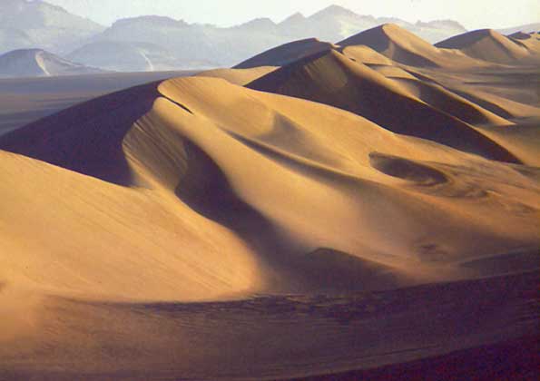
The hills themselves are extremely diverse in shape and height. Some vertices resemble well-known bodies in geometry: cones, pyramids, prisms, while others have more bizarre outlines. The forms of hills in the deserts are especially varied - sometimes in the form of columns, sometimes pillars, sometimes mushrooms, and in some places forms are formed that resemble the ruins of ancient cities, fortresses and some giant fantastic structures.
The steep surfaces of rocks in mountainous deserts are often covered with many depressions (cells) of various shapes, which gives such a surface the appearance of a honeycomb.
Each landform is bounded by slopes of varying steepness. The intersection of two opposite slopes of the ridge - his crest - forms a dividing line. In flat terrain, where flat, almost horizontal surfaces predominate, it is often difficult to establish the position of the watershed line, since it is replaced by an entire watershed strip, usually swampy or occupied by lakes. This kind of watershed
spaces are typical for the West Siberian Lowland, where the slightly convex surfaces of the watersheds are occupied by vast, highly moistened moss bogs, among which there are countless lakes with swampy peat shores.
On the bottom of depressions, bounded on both sides by slopes - valleys, ravines, gullies - there is a spillway, or thalweg. In river valleys, the drainage line coincides with the riverbed.
Slopes limiting any elevation rarely have the same steepness from top to bottom. Most often, the steepness changes, and this change is sharply noticeable to the eye and is observed along a certain line. If there is a break in the steepness of a slope, and a slope of great steepness is replaced by a slope of less steepness, then the line along which the steepness changes is called the plantar line.

The plantar line delimits the bases of isolated hills and other elevations that stand out prominently in the area.
If there is a change in the steepness of the slope and the slope of a lesser steepness is replaced by a slope of greater steepness, then the line along which the change in steepness occurs is called a curb. The edge line limits the slopes of ravines, gullies, gullies, river valleys from above.
Depicting the relief on a map, the topographer first of all tries to identify on the ground and then to map the lines of watersheds, thalweg, soles of slopes and edges, which form, as it were, a "skeleton" of the relief.
For correct understanding relief In another territory, its characteristic points are also of great importance. These include summit, saddle-wine, estuarine and bottom points.
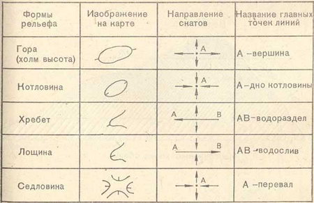
Vertex points are located on the the highest places of the hills, and from them the farthest can be seen the surrounding area. On the topographic maps usually the heights of these points above sea level are labeled. The points from which the terrain is especially clearly visible in all directions are called command points. The heights of these points on the maps are labeled in large print to make them stand out better.
They are located in the lowest places of mountain ridges and generally watershed lines. V mountainous areas the lowest saddles are usually the most comfortable seats for the transition from one slope of the ridge to the opposite. These saddles are called passes or mountain passes.
At the bottom of river valleys, ravines and gullies, mouth points are located. These are the mouths of rivers, ravines or gullies.
Bottom points characterize the depth of terrain depressions. They are located at the bottom of closed depressions, hollows and other relief depressions. So, for example, the deepest (bottom) point of the huge Turpan depression, located in Western China, has a height of minus 154, that is, it is 154 m below ocean level.
By outward appearance landforms can be divided into two main groups: positive and negative - depending on their position relative to the horizon plane.
Positive include mountain ranges, hills, ridges, mounds and other heights.
Negative landforms represent concavities, depressions, or depressions relative to the horizon. These include river valleys, ravines, gullies, hollows, depressions, etc.
Look at a mound, a hill, a hillock, and some kind of hollow. You will see that they are bounded on all sides by slopes. Therefore, such landforms are called closed.
Non-closed landforms are limited by slopes on two or three sides, such as river valleys, ravines.
Landforms are simple and complex. So, for example, a gully, a hillock, a mound, etc., can be attributed to the number of simple forms.
In contrast to simple shapes, complex landforms include several simple shapes and are usually larger in size. River valleys are always complex landforms: their slopes, as a rule, are dissected by ravines, gullies, gullies and hollows. Any mountain ridge is also a complex form of relief: its slopes are cut by gorges, smaller ridges always extend to the sides from the ridge, etc.
Therefore, in the form of relief, you can always find several simple forms. When studying the relief, they help sort out in the features of the relief and understand the conditions of its occurrence.
Only by studying individual forms of relief and understanding the conditions of their formation, it is possible to correctly determine the paths of development of the relief as a whole. And this is necessary in the design and construction of structures, in the construction of roads, in agriculture and in other areas. economic activity person.
The East European Elevated Plain consists of elevations with heights of 200-300 m above sea level and lowlands along which flow large rivers... The average height of the plain is 170 m, and the highest - 479 m - on Bugulma-Belebey Upland in the Urals part. Maximum elevation Timan ridge slightly less (471 m).
According to the peculiarities of the orographic pattern, three stripes are clearly distinguished within the East European Plain: central, northern and southern. Across central part the plains is a strip of alternating large hills and lowlands: Central Russian, Volga, Bugulma-Belebey Uplands and Common Syrt divided Oka-Don lowland and the Low Trans-Volga region, along which the Don and Volga rivers flow, carrying their waters to the south.
North of this strip is dominated by low plains, on the surface of which, here and there, smaller hills are scattered with garlands and one by one. From west to east-northeast, they stretch here, replacing each other, Smolensk-Moscow, Valdai Uplands and Northern Uvaly... They are mainly used for watersheds between the Arctic, Atlantic and internal (closed-drainage Aral-Caspian) basins. From the Northern Ridges, the territory decreases to White and The Barents Seas... This part of the Russian Plain is called the "northern slope". Large rivers flow along it - Onega, Northern Dvina, Pechora with numerous high-water tributaries.
The southern part of the East European Plain is occupied by lowlands, of which only the Caspian region is located on the territory of Russia.
Rice. 2. Geological profiles across the Russian Plain
The East European Plain has a typical platform relief, which is predetermined by the tectonic features of the platform: the heterogeneity of its structure (the presence of deep faults, ring structures, anteclises, syneclises and other smaller structures) with unequal manifestation of the latest tectonic movements.
Nearly all major highlands and lowlands of the plain tectonic origin, with a significant part inherited from the structure of the crystalline basement. In the process of a long and difficult path development, they formed as a single territory in the morphostructural, orographic and genetic relation.
At the base of the East European Plain lie Russian plate with Precambrian crystalline basement and northern edge in the south Scythian plate with a Paleozoic folded basement. The border between the slabs is not expressed in the relief. On the uneven surface of the Precambrian basement of the Russian Plate, strata of Precambrian and Phanerozoic sedimentary rocks with slightly disturbed occurrence lie. Their thickness is not the same and is due to the unevenness of the basement relief (Fig. 1), which determines the main geostructures of the slab. These include syneclises - areas of deep basement (Moscow, Pechora, Caspian, Glazovskaya), anteclises - areas of shallow basement (Voronezh, Volga-Ural), aulacogenes - deep tectonic ditches, in the place of which syneclises subsequently appeared (Kresttsovsky, Soligalichsky, Moskovsky, etc.), protrusions of the Baikal basement - Timan.
Moscow syneclise- This is one of the most ancient and complex internal structures of the Russian plate with a deep crystalline basement. It is based on the Central Russian and Moscow aulacogens filled with thick Riphean strata, above which the sedimentary cover of the Vendian and Phanerozoic (from the Cambrian to the Cretaceous) lies. In the Neogene-Quaternary time, it experienced uneven uplifts and in the relief it is rather expressed. large hills- Valdai, Smolensk-Moscow and lowlands - Verkhnevolzhskaya, North-Dvinskaya.
Pechora syneclise is located wedge-shaped in the northeast of the Russian plate, between the Timan ridge and the Urals. Its uneven block foundation is lowered to various depths - up to 5000-6000 m in the east. The syneclise is filled with a thick stratum of Paleozoic rocks overlain by Meso-Cenozoic sediments. In its northeastern part there is the Usinsky (Bolshezemelsky) vault.
In the center of the Russian plate there are two large anteclises - Voronezh and Volga-Ural separated by Pachelm aulacogen... The Voronezh anteclise slopes gently to the north into the Moscow syneclise. The surface of its basement is covered with thin Ordovician, Devonian and Carboniferous deposits. Carboniferous, Cretaceous and Paleogene rocks occur on the southern steep slope. The Volga-Ural anteclise consists of large uplifts (arches) and depressions (aulacogenes), on the slopes of which flexures are located. The thickness of the sedimentary cover here is at least 800 m within the highest vaults (Tokmovsky).
Caspian marginal syneclise is a vast area of deep (up to 18-20 km) subsidence of the crystalline basement and belongs to structures of ancient origin, almost on all sides of the syneclise it is bounded by flexures and faults and has angular outlines. From the west it is framed by the Ergeninskaya and Volgograd flexures, from the north - flexure of Obshchy Syrt. In some places they are complicated by young faults. In the Neogene-Quaternary, further subsidence (up to 500 m) and the accumulation of a thick layer of marine and continental sediments took place. These processes are combined with fluctuations in the level of the Caspian.
southern part The East European Plain is located on the Scythian Epigercyn Plate, which lies between the southern edge of the Russian Plate and the Alpine folded structures of the Caucasus.
Tectonic movements of the Urals and the Caucasus have led to some disruption in the occurrence of sedimentary plate deposits. This is expressed in the form of dome-shaped uplifts, significant along the length of the swells ( Oksko-Tsniksky, Zhigulevsky, Vyatsky and others), individual flexural bends of layers, salt domes, which can be clearly traced in the modern relief. Ancient and young deep faults, as well as ring structures, determined the block structure of the plates, the direction of river valleys, and the activity of neotectonic movements. The predominant direction of the faults is northwest.
Short description tectonics of the East European Plain and a comparison of the tectonic map with the hypsometric and neotectonic maps allow us to conclude that the modern relief, which has undergone a long and complex history, is in most cases inherited and dependent on the nature of the ancient structure and manifestations of neotectonic movements.
Neotectonic movements on the East European Plain manifested themselves with different intensity and direction: in most of the territory they are expressed by weak and moderate uplifts, weak mobility, and the Caspian and Pechora lowlands experience weak subsidence.
The development of the morphostructure of the north-west of the plain is associated with the movements of the marginal part of the Baltic shield and the Moscow syneclise; therefore, there are developed monoclinal (inclined) bed plains, expressed in orography in the form of hills (Valdai, Smolensk-Moscow, Belorusskaya, Northern Uvaly, etc.), and stratal plains occupying a lower position (Verkhnevolzhskaya, Meshcherskaya). The central part of the Russian Plain was influenced by the intense uplifts of the Voronezh and Volga-Ural anteclises, as well as the subsidence of neighboring aulacogens and troughs. These processes contributed to the formation layer-tiered, stepped elevations(Central Russian and Volga) and the Oksko-Don plain. The eastern part developed in connection with the movements of the Urals and the edge of the Russian plate; therefore, a mosaic of morphostructures is observed here. Developed in the north and south accumulative lowlands edge syneclises of the plate (Pechora and Caspian). Alternating between them stratal-tiered uplands(Bugulminsko-Belebeevskaya, General Syrt), monoclinal-bed Uplands (Verkhnekamskaya) and intra-platform folded Timansky ridge.
In the Quaternary, a cooling of the climate in the northern hemisphere contributed to the spread of ice sheets. Glaciers had a significant impact on the formation of relief, Quaternary deposits, permafrost as well as to change natural areas- their position, floristic composition, fauna and migration of plants and animals within the East European Plain.
Three glaciations are distinguished on the East European Plain: Okskoe, Dnieper with the Moscow stage, and Valdai. Glaciers and fluvioglacial waters created two types of plains - moraine and outwash. Permafrost processes prevailed in the wide periglacial (preglacial) belt for a long time. Snowfields had an especially intense effect on the relief during the period of reduced glaciation.
Morena of the most ancient glaciation - Oksky- was studied on the Oka, 80 km south of Kaluga. The lower, heavily washed-out Oka moraine with Karelian crystalline boulders is separated from the overlying Dnieper moraine by typical interglacial deposits. In a number of other sections to the north of this section, under the Dnieper moraine, the Oka moraine was also found.
Obviously, the moraine relief that arose in the Oka Ice Age has not survived to our time, since it was first washed out by the waters of the Dnieper (Middle Pleistocene) glacier, and then it was covered by its bottom moraine.
Southern border maximum spread Dniprovsky integumentary glaciations crossed the Central Russian Upland in the Tula region, then descended with the tongue along the Don valley - to the mouth of the Khopr and Medveditsa, crossed the Volga Upland, then the Volga near the mouth of the Sura River, then went to the upper reaches of the Vyatka and Kama and crossed the Ural in the area of 60 ° N. In the basin of the Upper Volga (in Chukhloma and Galich), as well as in the basin of the Upper Dnieper above the Dnieper moraine, the upper moraine lies, which is attributed to the Moscow stage of the Dnieper glaciation *.
Before the last Valdai glaciation in the interglacial epoch, the vegetation of the middle zone of the East European Plain had a more thermophilic composition than the modern one. This testifies to the complete disappearance of its glaciers in the north. In the interglacial epoch, peat bogs with Brazen flora were deposited in lacustrine basins formed in depressions of the moraine relief.
In the north of the East European Plain, the boreal ingression arose during this era, the level of which was 70-80 m above the present-day sea level. The sea penetrated along the river valleys of the Northern Dvina, Mezen, Pechora, creating wide branching bays. Then came the Valdai glaciation. The edge of the Valdai ice sheet was located 60 km north of Minsk and went to the northeast, reaching Nyandoma.
In the climate of the more southern regions, due to glaciation, there have been changes. At this time in more southern regions In the East European Plain, remnants of seasonal snow cover and snowfields contributed to the intensive development of nivation, solifluction, and the formation of asymmetric slopes in erosional landforms (ravines, gullies, etc.).
Thus, if ice existed within the distribution of the Valdai glaciation, then in the periglacial zone a nival relief and sediments (boulderless loams) were formed. The non-glacial, southern parts of the plain are overlain by thick strata of loess and loess-like loams, synchronous with the ice ages. At that time, in connection with the humidification of the climate, which caused glaciation, and also, possibly, with neotectonic movements in the basin of the Caspian Sea, marine transgressions took place.
Natural processes of the Neogene-Quaternary time and modern climatic conditions on the territory of the East European Plain, they caused various types of morphosculptures, which are zonal in their distribution: on the coast of the seas of the Arctic Ocean, sea and moraine plains with cryogenic relief forms are widespread. To the south lie moraine plains, transformed at various stages by erosion and periglacial processes. Along the southern periphery of the Moscow glaciation, a strip of outwash plains is observed, interrupted by remnant elevated plains covered with loess-like loams, dissected by ravines and gullies. To the south, there is a strip of fluvial ancient and modern landforms in the highlands and lowlands. On the coast of the Azov and Caspian Seas, there are Neogene-Quaternary plains with erosional, depression-subsidence and aeolian relief.
The long geological history of the largest geostructure - the ancient platform - predetermined the accumulation of various minerals in the East European Plain. The richest deposits are concentrated in the platform foundation iron ore (Kursk magnetic anomaly). Deposits are associated with the sedimentary cover of the platform coal (East End Donbass, Moscow region basin), oil and gas in Paleozoic and Mesozoic sediments (Ural-Volga basin), oil shale(near Syzran). Building materials are widespread (sands, gravel, clays, limestones). The sedimentary cover is also associated with brown iron ore(near Lipetsk), bauxite(at Tikhvin's), phosphorites(in some areas) and salt(Caspian region).
Distinguish between positive (rising above the surface) and negative (deepening from the surface) landforms.
Surface irregularities crust can be of different order.
Greatest (planetary) forms relief - these are oceanic troughs (negative form) and continents (positive form)
The area of the earth's surface is 510 million square kilometers. of which 361 million sq. km (71%) and occupies only 149 million square meters. km (29%) - land
The land area is unevenly distributed among the oceans. In the Northern Hemisphere, it occupies 39% of the area, and in the Southern - only 19%.
The mainland or part of the mainland with nearby islands is called part of the world.
Parts of the world: Europe, Asia, America,. Oceania is distinguished as a special part of the world - a set of islands in the central and southwestern part.
Continents and islands divide a single World Ocean into parts - the oceans. The boundaries of the oceans coincide with the shores of continents and islands.
The oceans protrude into the land with seas and bays.
Sea - a part of the ocean, more or less separated from it by land or elevations of the underwater relief. There are marginal, inland, inter-island seas.
The bay - a part of the ocean, sea, lake, jutting deep into the land.
Strait - a relatively narrow body of water, bounded on both sides by land. The most famous straits are: Bering, Magellan, Gibraltar. Drake Passage is the widest, 1000 km, and the deepest, 5248 m; the longest is the Mozambique Strait, 1760 km.
Planetary relief elements are divided into relief forms of the second order - mega-forms (mountain structures and large plains). Within the megaforms, there are macroforms (mountain ranges, mountain valleys, depressions of large lakes). On the surface of macroforms, there are mesoforms (medium-sized forms - hills, ravines, gullies) and microforms (small forms with height fluctuations of several meters - dunes, gullies).
Mountains and plains
- vast areas of land or ocean floor, significantly elevated and highly dissected. The mountain is a solitary rise with a summit having a relative height of more than 200 m. Most of these mountains are of volcanic origin. In contrast to the mountain, the hill has a lower relative height and more gentle slopes, gradually turning into a plain.
Mountain ranges are linearly elongated uplifts with clearly defined slopes and ridge. The crest of the ridge is usually very uneven, with peaks and passes. Ridges join and intersect to form mountain ranges and mountain knots - the highest and most difficult parts of the mountains. Combinations of mountain ranges, often heavily eroded, intermontane basins and leveled upland areas form uplands. According to the absolute height, mountains are distinguished high (above 2000 m), medium-high (800 - 2000 m) and low (no higher than 800 m).
The general pattern of changes in relief with height is his. The higher, the more intense weathering in the mountains. The tops of the mountains, rising above the snow line, bear on themselves. Glacial tongues descend below, feeding violent mountain streams, streams dissect slopes with deep valleys, move pumps down. At the foot, pumps and material crumbling from the slopes are glued together, smoothing out the bends of the slopes, creating foothill plains.
- areas of the surface with small differences in heights. Plains with absolute height no more than 200 m, called lowlands; no more than 500 m - elevated; above 500 m - upland or plateaus. On the continents, most of the plains were formed on platforms and folded layers of the sedimentary cover (stratal plains). Plains that have arisen as a result of the removal of destruction products from the remaining base of the mountains (basement) are called basement. Where material accumulates, leveling the surface, accumulative plains are formed. Depending on the origin, the plains are sea, lake, river, glacial, volcanic.
The deep-water plains are hilly, undulating, less often flat. Significant strata of sediments accumulate at the foot of the continental slope, forming inclined plains. The flat relief also has a shelf. Usually it represents the outskirts of a platform below sea level. On the shelf, there are landforms, river beds, and glacial landforms.
Formation of the Earth's relief
Features of the Earth's relief