The Trans-Baikal Territory occupies a large territory, and more than a million people live in it. Many interesting places are concentrated in this square. In the Trans-Baikal Territory, attractions are associated with nature, culture, religion and many other areas.
The park was founded in 1999. It is located in the Duldurga region and occupies about 1400 sq. km. This area is unique in its geological characteristics. It is inhabited by:
- mammals - more than 30 species;
- birds - about 100 species;
- fish and amphibians - more than 20 species;
- insects - more than 400 species;
- plants - more than 1000 species (including lichens).
There are many natural attractions and historical and cultural sites in the park:
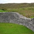
- natural monuments: Alkhanai char and Uuden Sume natural arch;
- rocky outliers: Damchog Sume, Zaguurdi, Sandama, Naro Khazhod, Khoreo Shuluun;
- caves: Ekhyn Umai, Temple of Badmasambava;
- the statues of Otosho, Namnanai Bagshi and the white Chakrasamvara;
- Buddhist temple Damchog Dugan;

- stone chapel;
- memorial suburgan to the XIV Dalai Lama;

- cascade of waterfalls Nine troughs;
- tiled burial grounds;
- stone slabs of Maniin Shuluun.
There are 6 routes for tourists with a length of up to 6,000 km, 2 of which involve the possibility of movement by car.
The reserve is considered one of the seven wonders of Transbaikalia and is a UNESCO World Heritage Site. The reserve is located in South-Eastern Transbaikalia and covers an area of 45.8 hectares. It was organized at the end of 1987 to protect bird nests.
The reserve is represented by steppe, lake-steppe, forest and wetland landscapes. Protected areas are surrounded by a buffer zone. In the village of Nizhniy Tsasuchey (Ononsky district), the central estate of the reserve was organized.
The fauna of the reserve includes more than 300 species of birds, and a third of them are included in the Red Book. Fifty species of mammals also live here, including the gazelle antelope, Daurian hedgehog, tarbagan marmot and cat-manul, which are listed in the Red Book.

This large Buddhist monastic complex is called the Braibunling Dam. It is located in Chita, and was founded in 2002. Today, khural services and various rituals are held here.
The territory of the datsan is an ideal square with a side of 108 m - a sacred number. The prayer temple is also square. The building has three tiers, a tiled roof and carved elements - the datsan-museum, which burned down in the last century, was taken as a model.
The central part of the temple is occupied by a two-meter statue of Buddha, which weighs 200 kg. In front of the entrance to the building, you can see a sacrificial censer (800 kg) and cast-iron statues of lions. Temple attendance is not limited by gender, age, or religion.

The reserve is a state reserve, located on the Khentey-Chikoiskiy highlands (south of Transbaikalia). It was founded at the end of 1973 and occupies almost 211 thousand hectares, including 36 thousand hectares of the protected area. Most of the area is occupied by forests, so the reserve is considered mountain taiga.
The flora and fauna of the reserve includes about 1000 vascular plants, 250 species of birds, 67 species of mammals, 1200 species of insects. The area is a UNESCO Biosphere Reserve.

Tourists are offered several ecological routes. Some of them are more than 200 km long and last up to a week. Moving is possible on foot, by car, or by horse.
This tract is one of the seven wonders of Transbaikalia - the place was included in this list in 2010. It is a sandy massif covering an area of about 3000 hectares. This small desert is located in the Chara depression (foothills of the Kodar), 9 km away is the village of Chara (Kalarsky district).
Chara sands are surrounded by swamps and larch trees (taiga) - this combination with the desert is unique. The sand is quartz, fine and medium-grained. Ridges and dunes are formed from it, the height of which can reach 80 m, and the length - 170 m. Outwardly, the area resembles a Central Asian desert.
From the desert, you can see the snow-capped peaks of the mountains, which seem to be close. In fact, they are about 40 km away.

This functioning Buddhist monastery is called Dashi Choypelling and is the oldest in the Trans-Baikal Territory. It was founded at the beginning of the 19th century. Datsan is located in the Mogoytuysky region (Tsugol village, Aginsky Buryat district).
The datsan was founded by three Agin clans. The main element of the architectural ensemble is the main temple. It combines Chinese and Tibetan architecture - traditional elements of Buryat temple architecture. Buddhist services are held in the temple every day. This place can be visited by a person of any gender, age and religion.

This national park was founded in 2014 and covers about 666,500 hectares. It included the liquidated Burkalsky and Atsinsky reserves.
The fauna of the park includes common and Siberian pine, fir, Siberian spruce, larch, dwarf cedar and a number of other plants, including 38 protected species. The fauna of the reserve is also rich - 155 species of birds, 67 species of mammals, fish, amphibians. Some representatives of the park's fauna are listed in the Red Book.
The territory of the park includes several natural monuments, including Bystrinsky char (mountain), Shebetui lake, Lamsky Gorodok tract.

The temple was founded in December 2001 and belongs to the seven wonders of Transbaikalia. It is located on the station square in the center of Chita. The cathedral was built with donations.

The size of the temple is impressive - in Siberia, it is the largest and accommodates 2500 people, although on big holidays it turns out to be twice as many people. The cathedral is attracted by a 60-meter bell tower. The main bell weighs 10 tons and is the largest in Siberia.
The interior of the temple consists of three parts - the vestibule, the central nave and the altar, separated from the central nave by a wall of icons. The temple library is noteworthy, consisting of several thousand books, mainly Orthodox literature. A Sunday school is organized for children.
It is located on the steppe plain of the same name and occupies about 46,000 hectares. The facility was formed in 2004.
The flora and fauna of the reserve includes unique plant communities (Green Book of Siberia), rare species of birds and mammals, including bustard, Daurian and black crane. Many representatives of the animal world are listed in the Red Data Books. The diversity of bird species accounts for more than a third of the avifauna of the former USSR. Ephemeral wetland complexes are widespread on the territory.

This complex of caves is located in the southeast of the Trans-Baikal Territory, 7 km from the village of Ust-Borzya. The object is a natural monument and consists of two karst caves - Sukhaya and Mokruya. The total length is approximately 150 m.
You can get into them only by going down the steep icefall. The descent is 12 m. The Wet Cave includes several galleries and grottoes. Water enters here and solidifies, forming magnificent natural sculptures. Once the caves were inhabited - human bones, fragments of tools of labor of primitive people were found here.

It is dangerous to visit the caves on your own, but you can do it on special tours - they are organized several times a month during the season.
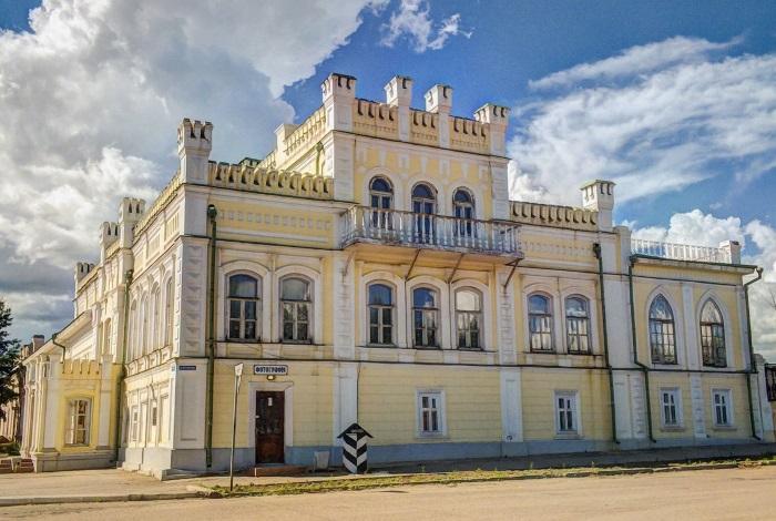
The object is the Nerchinsk Museum of Local Lore and is located in Nerchinsk. The building was founded in the second half of the 19th century. It owes its name to the Butin family who owned it. The palace is considered the hallmark of the city, and its main exhibit is a Venetian mirror - a square with a side of 4 m, which caused a lot of controversy about how it was brought into the palace hall.
Much of the luxurious furnishings of the palace have been lost. A spiral staircase, part of the carved elements, a huge chandelier in the ballroom, paintings, including the original by Aivazovsky, have survived.
Today the palace houses a local history museum. The number of its exhibits is over 20 thousand. The museum belongs to one of the seven wonders of Transbaikalia.
Mount Pallas and the Great Source
This mountain is also called Vodorazdelnaya, the Great Divide, the Mountain of Five Seas - the rivers flow into 4 seas, and Baikal is called the fifth. It is located on the Yablonovy Ridge, in the west of the Trans-Baikal Territory. The absolute height is 1236 m. The mountain is called the Point of the Great Divide, as it is the source of three great rivers - the Yenisei, Amur and Lena.
Pallas is located 35 km north-west of Chita and is included in the territory of the Ivano-Arakhleisky reserve. There are several tourist routes, but it is more convenient to go through the Dvortsy tract. The length of the route is about 17 km.
The great source is considered an abnormal place and attracts people who believe in mysticism. They make up only a part of tourists - the rest value, above all, the uniqueness of the place and its magnificent nature.

Ivano-Arakhleysky nature reserve and Beklemishevsky lakes
The lakes are also called Ivano-Arakhleyskiy or Chita lakes. They represent the center of the reserve, the territory of which is protected.
The lakes are located to the west of Chita at an altitude of almost 1 km above sea level. The system consists of 6 large lakes, the water surface of which is 10 sq. km, as well as shallow bodies of water. 4 lakes belong to the Baikal system.
The reserve was founded in 1993 and occupies 210 thousand hectares. Its territory includes many recreation centers, which annually attracts more than 150 thousand tourists here. In the reserve there are more than half a thousand species of vascular plants, about 150 species of birds, 40 species of mammals and 800 species of insects.
This building is called the most beautiful in Chita. It was founded at the beginning of the 20th century by the Shumov brothers, who own the Kruchininsky mines. Today it houses the headquarters of the Federal Security Service of the Russian Federation for the Trans-Baikal Territory. There is also a small Museum of Management History, where among the exhibits there is a replica of the Chekist's office - the furniture is genuine, dating back to the middle of the 20th century.
The building claimed the title of one of the seven wonders of Transbaikalia. Previously, this building was the focus of the business and cultural life of not only the entire city, but also the region. The building is perfectly preserved. This also applies to the rich stucco decoration. The building consists of three floors, decorated with domes, figured parapets, decorative white columns.

This object is called one of the seven wonders of Transbaikalia. It is a natural monument. The lake is located in the Uletovsky region and is located almost a kilometer above sea level. Ares feeds on groundwater. Its water surface is 4.6 square kilometers, and its maximum depth is 13.5 m.

The water in the lake is slightly alkaline and slightly mineralized. The lake is actively used for recreation - its healing waters and mud are effective in treating skin diseases and trophic ulcers.
Arey is surrounded by a pine forest, and its surroundings are rich in vegetation. There are two tourist bases on the coast: Arey and Kristall. The lake is attractive not only for its healing properties, but also for fishing.
The building was founded at the beginning of the 18th century. It is located in the village of Kalinino and is considered one of the seven wonders of Transbaikalia. There are few such places of worship preserved in Siberia.
The building was renovated in the second half of the 19th century. The church today is the oldest among the religious buildings of the pre-revolutionary period. Currently, the building is very neglected. The temple is not active, but it is not difficult to imagine its former greatness. The restoration of the church is planned.

This mountain range is located in the north of Transbaikalia and is its highest point: the absolute height is more than 3000 km. It is often called the Transbaikal Alps. The ridge is 200 km long.
There are more than 30 glaciers on Kodar, which are natural monuments. The ridge is crossed by the Chara River, in the middle course of which there is charoite - a mineral used in jewelry.

This place is a small hanging valley in the Kodar mountain range. Previously, there was the Marble Mine, where uranium was mined - the main labor force was the prisoners. Remnants of that time are the destroyed camp, towers, a bridge - wooden buildings have been partially preserved to this day. Thanks to the cold climate, some household items have also survived: metal utensils, stoves.
A memorial plate to the climbers who took part in the development of the mine was installed on the territory.

Today this building is a museum, but once there was the Archangel Michael Church. It was founded in 1776 and is located in Chita. The museum was opened in 1985.
The building is made of wood and is the oldest in Chita. The collection of the museum includes documents, books, letters, household items, personal belongings of the Decembrists who were exiled to Siberia. In total, there are about 900 museum exhibits, including Bestuzhev's table and clock, Volkonskaya's casket. The transfer of the building to the museum is also connected with the fact that the Decembrists used to get married in the church, and the Volkonskys' daughter was buried next to the church.

Cauldron Stone, Maliy Bator and Big Bator
This rock is also called Togon Shuluun or the Chalice of Genghis Khan. The object is located in the Aginsky region and is a 4-meter high rocky outlier of natural origin. The rock got its name due to its external resemblance to a tripod - an old pot.

For local residents, the cauldron stone is a place of worship. There is a path around the cliff - the path of the city. The stone must be traversed an odd number of clockwise times.
The Small Bator tract is also called Baga-Bator. It belongs to the territory of the Aginskaya steppe reserve and represents granite outlier rocks surrounded by trees - a sharp contrast to the local steppe.

Big Bator is located across the road and is the highest surrounding peak. There is a monument to Babzhi-Baras-bator, a legendary hero, on the mountain.
The Trans-Baikal Territory is a vast territory with unique nature. It is with this fact that most of the attractions of this place are connected. Many objects are natural monuments. Other attractions reflecting the history, religion and culture of the region are also of interest to tourists.
The Trans-Baikal Territory is located in the eastern zone of Transbaikalia. It is part of the Trans-Baikal Territory is famous for its historical and natural monuments, attractions in this place are at every step. The area of this territory is 2.52% of the area of the Russian Federation. Everything here conquers with its scale and uniqueness. The main attractions of the Trans-Baikal Territory constantly attract tourists. At all times, people were amazed by the variety of relief, natural beauty and
Attractions of the Trans-Baikal Territory
A photo describing these beautiful places can be found in the article. But it is best to visit Transbaikalia in person. This is the only way to feel the greatness of nature, the height of mountain peaks and the vastness of the steppes. Tourists are recommended to visit such places:
- Sokhondinsky reserve;
- Lake Arey;
- Alkhanay National Park;
- ridge Kodar;
- Butinsky Palace;
- numerous museums.
Sokhondinsky reserve
In this reserved place, nature is striking in its diversity. Several ecological systems are connected in it:
- taiga;
- steppe;
- swamps;
- mountain tundra.
The length of the reserve is 211 thousand hectares. It is located on the Khentei-Chikoiskiy highlands with the Sokhondo mountain range. The Sokhondo char is the oldest volcano. Its slopes delight with whimsical forms.
This place is characterized by dry and little snowy winters. The climate is continental. There are many lakes of glacial origin here. Their depth is more than twenty meters. Plankton and algae do not take root in them, in this regard, they are famous for their transparency, the water there is with a light blue tint.
In the Sokhondinsky Nature Reserve, rivers such as the Selenga, Amur, Angara, Yenisei originate. It is noteworthy that they belong to the basins of different oceans. Amur belongs to the Pacific Ocean, and Selenga, Yenisei, Angara - to the Arctic.
In these parts of the world grow rare plants, which are included in the Red Book, such as leafless napkin, real slipper, large-flowered slipper, smooth iris, spotted slipper, Siberian apricot, dwarf and Pennsylvanian lily, Altai onion, Ayan lumbago, a couple of Rhodiola species.
The animal world also captivates with its diversity. At the moment, it has been found that 255 species of various birds, 67 mammals, three species of amphibians, four are reptiles, eight are fish and 1200 are arthropods.

Lake Arey
This reservoir is a hydrological natural monument. If we talk about the Trans-Baikal Territory, the photos of the attractions of which are in this article, first of all it is worth mentioning this wonderful lake. His fame is due to a combination of a number of factors:
- the lake amazes with the variety and quantity of fish, which is undoubtedly a huge plus for avid fishermen;
- the waters of the Areya contain a lot of oxygen, but are poorly mineralized;
- mud at the bottom has healing qualities, eliminates numerous skin diseases;
- on the southern coast there are huge anthills built by northern ants, some of the structures are 2-3 meters in diameter;
- at the very bottom of the Areas grows a unique Areian potato, it cures diseases of the gastrointestinal tract.

Alkhanay National Park
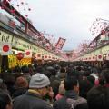
"Alkhanay" is located on the territory of the Duldurga region. It is famous for its natural beauty. The whole nature of this place is saturated with legends and beliefs. Since ancient times, the Buryat-Mongol tribes have fostered love for this land in their descendants. They called for the unity of a person with the world around him. In 1991, the head of the Buddhist clergy, the Dalai Lama, consecrated this land with his presence.
Every day, interest in the Alkhanay National Park is growing. A huge number of believers come here to worship sacred places and bathe in healing springs.
But the Trans-Baikal Territory can be proud not only of natural monuments. Historical sights are also striking in their uniqueness.

Transbaikal Alps - Kodar
This amazing place is located in the north of Transbaikalia. First of all, the Kodar ridge attracts tourists here. This is the highest point of Transbaikalia, a peak with a height of 3073 meters. The Kodar ridge clearly stands out among the highlands and middle mountains of Transbaikalia. Kodar is the "Trans-Baikal Alps". A traveler of any level can choose a route suitable for its complexity.

Butinsky Palace
This palace belonged to the noble Butin family, who built unique and inimitable buildings for various purposes in the city of Nerchinsk. If you study the sights of the Trans-Baikal Territory, it will become clear that the Butin Palace is undoubtedly the pride of the city of Nerchinsk.
A unique piece of the palace is a Venetian mirror. They say that there is no such huge thing in the world anymore. Its dimensions are 4 meters long and 4 meters wide. They even took apart the roof to fit it inside. The palace is also famous for its garden. Here you can find exotic plants that do not grow in the climate of these places.

Museum of the History of the SIBVO Troops
This landmark of the Trans-Baikal Territory was opened for the twentieth anniversary of victory in the Great Patriotic War. At the main doors there is an iron plate on which the names of 1255 Siberian warriors, Heroes of the Soviet Union, are immortalized. The three central halls are dedicated to the historical feat of the Russian people in the Great Patriotic War.
Everyone who goes to the Trans-Baikal Territory must visit these sights. We must pay tribute to the heroic deed of our ancestors.
This is just a part of the places for which the Trans-Baikal Territory is famous. Its sights can still be enumerated and enumerated. But it is better to go to this beautiful land and personally visit each of them.
ZABAIKALSKY REGION: FIGURES AND FACTS
The Trans-Baikal Territory is a constituent entity of the Russian Federation located in eastern Transbaikalia and part of the Siberian Federal District. It borders on the Amur and Irkutsk regions, the republics of Buryatia and Yakutia, has an external border with China and Mongolia. The territory of the region is 431, 892 km, which is 2, 53% of the area of Russia (12th place in this indicator in the Russian Federation). The population is 1 106 600 people. The Trans-Baikal Territory was formed on March 1, 2008 as a result of the unification of the Chita Region and the Aginsky Buryat Autonomous Okrug. The administrative center is the city of Chita. The most populated cities are Chita, Krasnokamensk and Borzya.
Climate

The region is characterized by a peculiar climate - sharply continental. Winter is long, dry and harsh, comparable to the Yakut one: the weather is frosty, slightly cloudy, calm. Summers are short and warm (sometimes even hot), but cool in the mountainous and northern regions. In spring, storms and snowstorms are possible, and the main precipitation falls from April to October. There are significant fluctuations in daily and annual temperatures, in some areas the spread is 90 degrees or more (average January temperature: -28.3 degrees; July: +19 degrees) degrees. The frost-free period is 80-140 days. We add that a characteristic feature of the climate is a significant number of sunny days per year, comparable to the south of Russia.
Economy

The Trans-Baikal Territory is very rich in various mineral resources and has relatively favorable conditions for agricultural activities. Direct transport access to the markets of the Asia-Pacific region provides a serious economic advantage. However, the progressive development of the region is hampered by the harsh natural and climatic conditions, the increased natural background radiation, high seismicity, and the dissection of the relief. For the regional economy, the implementation of a project to create a transport infrastructure for the development of rich mineral resources in the southeast of the region is of great importance.
Industry
The main industries are mining (mining of molybdenum, tin, lead-zinc and uranium ores, gold, coal), wood processing, ferrous and non-ferrous metallurgy, and electric power.
Agriculture
The Trans-Baikal Territory is a large agricultural region specializing in fine-wool sheep breeding. Meat and meat and dairy production, poultry farming, pig breeding are actively developing. The climatic conditions of the central, southern and southeastern regions make it possible to successfully practice crop production.
Tourist attraction

The Trans-Baikal Territory has the richest variety of flora and fauna, this is a godsend for tourists who prefer pristine nature and ecologically clean rest. The most fastidious will find rest to their liking: the region has mountains, northern desert, taiga forest, steppes, and deep rivers. History lovers will have plenty of food for thought in ancient cities. But first things first.
The mountains
The region is dominated by medium-altitude mountains (700-1000 meters). There are also peaks - the Kodar ridges in the north reach 2,999 meters, and in the south, Mount Barun-Shabarshui rises to 2,519 meters.
Forest
The natural diversity is amazing. These are taiga, forest, forest-steppe and even tundra.
Bodies of water

The Trans-Baikal Territory has a unique natural landmark: the Great Istok is located here, the place where the fresh waters of the entire planet are divided! Fresh water streams go to the Yenisei, Lena, Amur, Pacific and Arctic oceans and, of course, to the pearl of the Earth - Lake Baikal. The Baikal basin includes the right tributaries of the Selenga River - the Khilok and Chikoy rivers. And the Shilka and Argun Rivers merge into the powerful Amur. Of the most significant waterways, the Olekma and Vitim rivers (its tributaries - Karenga, Kalakan, Kalar) can be noted. The people of Transbaikal are rightfully proud of the whole collection of lakes. Bolshoye Leprindo, Leprindokan, Nichatka, for example, are children of the Ice Age. Popular places of rest are the unique salt-marsh lake Nozhiy, Ivano-Arakhleyskie lakes, Arey. Lake Kenon is located in the regional capital, right within the city limits.
Mineral springs and mineralized lakes
The fact that Transbaikalia is rich in healing waters was known even in tsarist Russia. Mineral springs differ in composition: from thermal nitrogen to cold carbon dioxide, low and medium mineralization. Many of them have health resorts - the resorts of Yamarovka, Shivanda, Darasun, Molokovka, Kuka, Yamkun, Aksha and many others.
Protected places

The region is rich in natural monuments, relict dwarf oaks, giants-cedars grow here, there are unique ecosystems (for example, Charsky Sands is a real desert in the middle of the taiga). To preserve nature in its original form, reserves and parks have been created: "Daursky", "Sokhondinsky", the national park "Alkhanay", 20 reserves. Soon there will be a natural park "Arey", work is underway to build the Chikoysky National and Kodarsky Parks.
Buddhist shrines

It is believed that Transbaikalia is a place prayed for by Buddhists. Most of the shrines are located on the territory of the Aginsky Buryat District: sacred mountains, o (Alkhanaysky, Adon-Chelonsky, Bolshebatoskiy). There are datsans (Aginsky, Tsugolsky, Ivolginsky and many others). Buryats very carefully preserve centuries-old traditions and customs. For tourists interested in ancient religion, this is a real Mecca. It will be interesting for the uninitiated.
Story cities
As you know, Transbaikalia is an exiled land. The Decembrists, who significantly influenced the course of the history of the region, left their bright mark. Chita, Nerchinsk, Sretensk, Petrovsk-Zabaikalsky and other cities cherish their memory. Houses, furnishings, records, photographs have been preserved. The region also has a centuries-old history of the Cossacks.
Summing up, we note that tourists have a large selection of directions: ecological (mountain, hiking, cycling and water sports tourism), cultural, educational, health-improving, religious, hunting and fishing.
Fabulous, unreal, bizarre, striking in their beauty - each of them is like a work of art embodied in reality.
The beautiful is near. The journalist of the newspaper "Zabaikalsky Rabochy" brings to your attention a selection of the most beautiful places of Transbaikalia, where you should visit.
At any time of the year, the forests of Transbaikalia are a work of art of Nature. In our region there are both pine forests and mixed forests, where you can find larch, aspen, birch and shrubs, and at the end of March - snowdrops covering our fields with a blue carpet. However, our forest becomes truly beautiful in late April - early May, when the Daurian rhododendron, or wild rosemary, as the inhabitants of the region affectionately call the shrub, blooms everywhere with a pink fire. It is listed in the Red Book and is rightfully considered one of the wonders of Transbaikalia.
It is worth special attention. Each lake has a unique, in its own way special beauty and charm, so we recommend visiting each of them.
Arakhley is the largest lake in the Ivano-Arakhlei system of lakes, distinguished by the greatest depth - in some places it reaches 20 meters. The bottom and the beach of the lake are sandy, and in summer there is a real full house on the shores of Arakhley. In the lake you can find perches, pikes and chebaks, which makes the lake a favorite place for fishermen. Anyway, having been there at least once, I want to return there again and again. And what kind of sunsets are there ...
Lake Shakshinskoe, or Shaksha

The second largest lake of the Ivano-Arakhlei system after Arakhley with sandy shores and well-warming water. The waters of Shaksha are inhabited by roach, perch, dace, pike, crucian carp, peled, bream, carp and catfish. Due to the abundance of fish and warm water in summer, the lake welcomes guests all year round, allowing us to admire its unique beauty.

Another lake of this system. Of all the names of the lakes in the Trans-Baikal Territory, the most noteworthy is the origin of the lake with a completely Russian name Ivan. According to legend, in order to deceive the evil spirits that take away children's lives, the parents tried to choose names that were unusual and unusual for the Buryats. And so, near one of the lakes lived Buryats Munko Udoev, whose children often died. Trying to preserve the offspring, the father named his next son Ivan. Tradition says that just at that time a disgraced priest named Ivan was wandering by the lake. Munko's son grew up and turned out to be more fortunate than his father, raising ten sons. The children grew up and began to live around the lake, which people called Ivan-Nuur, that is, Ivan-lake.

On the territory of the Trans-Baikal Territory, there is a unique national park, which is a monument of cultural heritage and home to endemic species of plants and animals. On the territory of this park, you can find more than 120 species of various animals, some of which are listed in the Red Book - such as the black stork, bustard and golden eagle. The complex includes more than 20 cultural sites, among which the most famous and revered are Maanin Shuluun (stone stele with a carved Tibetan text of the mantra), Dimchig Sume (Temple of God Dimchig - the owner of the mountain), Nara Hajad (Heavenly Musician), Uuden Sume (Temple of the Gate) , Dorje Pagmyn Sume (Temple of the Diamond Queen - the wife of the owner of the mountain), "The Sinners' Crevice", Ekhyn Umai (Mother's Womb), Zurkhen Shuluun (Stone Heart), Khoreo Shuluun (Stone Fence) and many others. One of the most important natural and cult sites is the summit of Alkhanay. The walking route throughout the park takes about 5 days. The waters from the Arshan springs are considered holy and are used for medicinal purposes, there are also clinics on the territory of the park.

, surrounded by pine forests, located at an altitude of 966 meters above sea level, characterized by magnificent landscapes. The waters of the lake have healing properties - they contain potassium, silicic acid, bromine, fluorine, lithium and other active elements. The work carried out by the Chita doctors showed that the waters and muds of the Areya have an excellent therapeutic effect and are indicated for the treatment of dermatitis and trophic ulcers. Currently, the mud is used by the Molokovka sanatorium.
5. Karpovskie rapids, upper river. Karpovka

Stunning stone rapids and frothing ice-cold water reminiscent of milk - this miracle can be seen with your own eyes, having visited the Karpovsky rapids. The waters of the Karpovka River have a constant temperature of -2 degrees Celsius and do not warm up even in summer.

One of the many rivers of Transbaikalia, cutting through the Chersky ridge, with a turbulent current and cold water, in which you can see grayling galloping on the rapids. In the upper reaches of Nikishikha there is a zoological reserve, and where the river passes through the ridge, a climbing wall has recently been built, where you can go with your family and, under the guidance of experienced instructors, conquer the rocks of the ridge.

Archaeological site of the Trans-Baikal Territory during the early Paleozoic. Local historians claim that this place owes its name to an unhappy officer by the name of Sukhotin, who was brought to the top of the formidable rocks by alcohol and unhappy love. He threw himself down and crashed against the stones, which Ingoda sharpens day and night, and a group of rocks and a section of the forest around were called Sukhotino. In order to visit there, it is enough to take a minibus to the Klyuchi plant and go up the river down the slope. All beauty is on the cliff. The rocks are piled above Ingoda to a height of 100 meters, and sitting on the top you can watch the slow and measured flow of the river, hear its quiet distant lapping, enjoy the view of the hills and breathe the cleanest air.

The widest, deepest river flowing in the Chita region. It is a pleasure to observe her changeable character - in some places she demonstrates a stormy disposition, quickly running along the rifts, and somewhere slowly and calmly carries her waters in a mirror-like surface so that the current is almost imperceptible. Ingoda is beautiful at any time of the year, the photo is captured in the winter tranquility of sleeping under a thick cover of an ice blanket.