In the previous material, we in general terms found out what happened to the Tethys Ocean (about those events, read the material The Tethys Sea and its fate). The story did not end there. The Mediterranean Sea and Paratethys became the descendants of Tethys - in the future it will turn into the Black and Caspian Sea... This story is about how today's Caspian Sea came into being. I must say, sometimes the Aral Sea is called among the relics of Tethys, but this sea simply appeared over the place where the bays of Paratethys disappeared long before, and the Aral basin is not its direct descendant.
Let us continue the description of events from the Upper Miocene (the Miocene is the epoch of that geological period, which is called the Neogene, the Miocene lasted from 23 to 5.2 million years ago). In this period of time, in the so-called Sarmatian age, 14.0 - 10.5 million years ago, an almost closed Sarmatian lake-sea was formed (Fig. 1), which had a difficult connection with the located to the south Mediterranean Sea... In this sea-lake, a peculiar brackish-water fauna of mollusks develops, consisting mainly of a few genera and species of lamellar and gastropods, the most common of which were various species of the genera Cardium, Mactra, Tapes, Trochus, Buccinum, Cerithium. Basically, according to the fauna of mollusks, in fact, the history of the Sarmatian Sea (as well as other ancient seas) and was restored. By the end of the Sarmatian century, due to the progressive desalination of the Sarmatian basin, the fauna of its mollusks becomes even more impoverished and is reduced to several species of the same genus Mactra, which are found in large numbers. Desalination of the basin is associated with the mass of fresh water that was brought by the rivers flowing into the basin, as for the modern Caspian Sea. In addition to molluscs, fish, of course, also lived in that sea (and in subsequent ones). Their views and appearance were similar to the modern inhabitants of semi-enclosed seas.
Fig. 1. Sarmatian Sea. Maximum dimensions.
The Sarmatian age was followed by the Meotic one. In the Meotic age (Fig. 2), 10.5–7.0 million years ago, the desalinated basin temporarily re-establishes communication with the open sea; its waters acquire greater salinity, and some marine stenohaline (that is, with a narrow saline range) species of mollusks again penetrate into it. This connection, however, is quickly interrupted. Late Miocene–early Pliocene (Pliocene–second Neogene era, 5.2–1.8 million years ago), Meotis was replaced by the next, Pontic Age. Its timeline is somewhere around 6.5– 5.2 million years. This Pontic basin, significantly reduced in size, is again freshened and populated by a monotonous poor brackish-water fauna (Fig. 3).
Fig. 2. Meotic sea. Maximum dimensions.
Fig. 3. Pontic lake-sea just before disintegration.
Subsequently, due to the continuing uneven uplift of the northern marginal strip of the geosynclinal area (in this area, due to the collision of Africa and Europe, the Alps and Caucasus mountains) and the adjacent marginal zone of the Russian Plate, the basin under consideration splits into a number of small isolated water bodies, the subsequent history of which was very different.
The collapse of the Pontic Basin occurred near the time boundary 6.5 million years ago. Among the reasons for the collapse is the uplifting of the Caucasus. In addition, there is another well-founded version of the reasons for the collapse. At this time, the Mediterranean Sea is experiencing the Messinian crisis, that is, it completely dries up due to the closure of the Strait of Gibraltar (the Mediterranean water evaporated, and nothing came to replace it from the ocean). It is very likely that at some point the Pontic Sea broke through the area of the Bosphorus and Dardanelles into the dried-up basin of the Mediterranean. This outflow of water caused, of course, a decrease in sea level, as a result of which it was divided into separate bodies of water.
One of these reservoirs, isolated at the end of the Sarmatian time (Pannonian), occupied the area of the Hungarian (Pannonian) lowland; gradually decreasing in size and increasingly freshening, by the end of the Neogene period (about 2 million years ago) it was almost completely drained. Its last remnant is Lake Balaton in Hungary.
The second basin, formed during the disintegration of the Pontic Lake-Sea - the Black Sea, or Euxine, - occupied the basin of the modern Black Sea. By the end of the late Pontus, about 5.2 million years ago, it had shrunk in size. The Northern Black Sea region and the shelf of the Azov-Black Sea basin dried up. Soon enough, when the Mediterranean Sea regained its depths (Gibraltar opened), from it to Black Sea the waters burst, forming the so-called Cimmerian Sea (5.0 - 3.4 million years ago).
The history of the development of the third large basin, which arose on the site of the Pontic lake-sea - the Caspian - turned out to be the most interesting and complex. By the middle of the Pliocene (Balakhanian age), it is greatly reduced in size (Fig. 4). The area of this Balakhany Lake, which filled only the depression of the southern Caspian Sea, exceeded the area of, for example, modern Ladoga Lake by 6-7 times. The Balakhany reservoir had a peculiar salinity regime. The presence of the ostracod fauna testifies to its freshwater quality. And the layers of minerals of gypsum, anhydrite, celestine, on the contrary, indicate its oversalinity. Apparently, the basin was indeed super-saline, and the freshwater fauna lived in estuaries and lagoons, into which rivers flowed. The reservoir itself consisted of a system of semi-insulated pools.
The rivers flowing into that Caspian (in particular, the paleo-Volga) cut deep and narrow gorges several hundred meters deep in the rock mass. Deltaic sediments of the Paleo-Volga formed an oil-bearing “productive” stratum up to 4000 meters thick in Lake Balakhanskoye.

Fig. 4 Ponto-Caspian region in the middle of the Pliocene (Balakhanian age). The Caspian Sea remained in the form of Lake Balakhany.
Later (Akchagyl age, 3.3–1.85 million years ago), the size of this sea, already the so-called Akchagyl, is greatly increasing (Fig. 5), especially in the north, and it receives communication over the lowlands of the Ciscaucasia with the Black Sea sea basin. The reason for this happened 3.5– 3.4 million years ago, the unification of Euxinus and the Caspian Sea was a general rise in the level of the World Ocean. Due to the unification, some stenohaline species of mollusks penetrate into the Akchagyl Sea, indicating a relatively high salinity of the waters.

Fig. 5. Kuyalnitsky (refers to the Black Sea) and Akchagyl basins. Shown maximum dimensions reservoirs.
The end of the Akchagyl age corresponds to the end of the Pliocene epoch. After a short regression at the beginning of the next, Quaternary, period, the Caspian is almost restored in the form of a new sea, the Apsheron Sea.
This sea rises to today's Kamyshin on the Volga, to Uralsk along the Ural River (Fig. 6). Its waters flood the plain Ciscaucasia, over the future Manych, connecting with the Black Sea, and joining the Aral reservoir. The Absheron Sea exists from 1.7 to 1 million years ago. During the retreat of the Absheron Sea, forests of the southern taiga type grew on its northern coast. Absheron time corresponds to the first section of the Quaternary period, called the Eopleistocene.
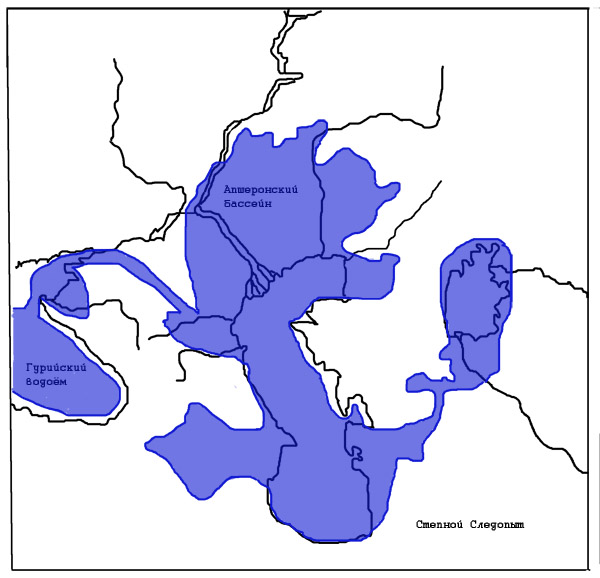
Fig. 6 Ponto-Caspian region in the Absheron age (maximum dimensions of the Absheron basin)
And further in the Quaternary period, in its second part - the Pleistocene (or Neopleistocene; then the Quaternary period as a whole is meant by the Pleistocene), the closed Caspian basin experienced sharp fluctuations in its level. The threefold expansion of the limits of the Caspian Sea is distinguished (against the background of these large, or great, transgressions, fluctuations of the smaller hierarchy took place). These transgressions of the Caspian Sea (Baku, Khazar, and Khvalynskaya), of which the last was the largest in terms of area (Fig. 7), and the regression phases between them are associated with abrupt changes climatic conditions on the Russian Plain - by the alternation of glacial and interglacial epochs, when the circulation regime of the atmosphere and the runoff of the Volga changed.
At present, it is believed that, for all the complexity, in general terms, the transgressions of the Caspian Sea in the Pleistocene coincide with cold snaps and glaciations in the central and northern regions of the Russian Plain, and regressions - with warming in the interglacial. Apparently, this pattern is explained by a decrease in evaporation from the surface of the Caspian Sea during cold, glacial, epochs and vice versa, by an increase in evaporation in warm times of interglacials.
While the World Ocean dropped quite clearly (by an amount of about a hundred meters) during periods of glaciation (a huge amount of water was bound in the ice sheets), the features of the actually closed, despite the existence of sometimes the Manych Strait, the Caspian and losing contact with the World Ocean of the Black Sea significantly complicate the behavior of the level of these seas ... Back in the middle of the 19th century, the great scientist Karl Baer (or, more precisely, Karl Maximillian von Baer) wrote “The changes to which the level and space of the Caspian Sea were subjected constitute the task that geology proposed to Russia, and in the solution of which it had to a chance to express my scientific strength and all my love for science. "
In the interval 600-500 - 400-350 thousand years ago, during the Baku transgression, the sea level reaches absolute marks of 40-50 meters, again reaching Kamyshin and Uralsk. Along the Manych, the Baku basin was connected to the Black Sea. Pine-spruce forests then grew in the Northern Caspian region, and steppes existed in the east. During the subsequent Oka glaciation, the sea level fell 30-50 meters below the present day - this was the Venedian regression.
In the Middle Pleistocene, in the interval of about 300-200 thousand years ago, in the place of the Caspian Sea, there was an early Khazar Sea, which was slightly inferior in size to the Baku one. The sea level gradually dropped during this era. The north of the Caspian was surrounded by cool steppes.
In the interval 120-80 thousand years ago, there was a late Khazar transgression, with a slight increase in the level.
20-12 thousand years ago, the most significant transgression occurred - the early Khvalynian, with a rise in the water level at least 70 meters above the modern ( a number of scholars believe that the early Khvalynian transgression took place 70– 50 thousand years ago). On the north coast Khvalynsky sea there were dry cool steppes with haze-wormwood plant groups, with a significant number of plants of wet salt marshes and solonetzes.
Later, about 7-9 thousand years ago (possibly 20- 10 thousand years ago, according to another opinion), a much smaller late Khvalynian transgression took place - already without the formation of the Manych Strait. It was replaced by the Mangyshlak regression, followed by the Novo-Caspian transgression (up to -20 meters absolute height, 6-4 thousand years ago).
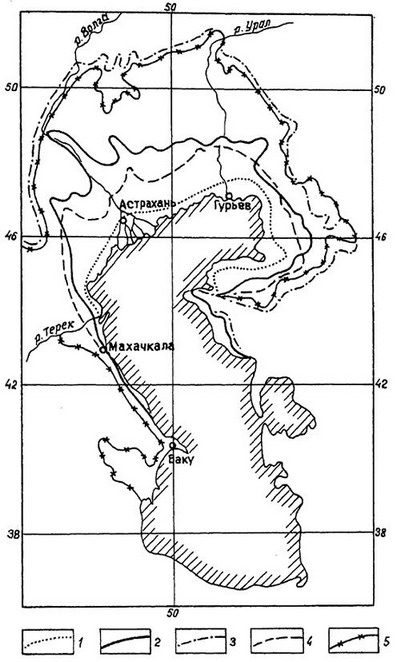
Fig. 7 The boundaries of the distribution of marine transgressions in the Caspian depression: 1 - new Caspian; 2 - late Khvalyn; 3 - early Khvalynsky (maximum); 4 - late Khazarian; 5 - early Khazarian
In the flat North Caspian, the sea coastline fluctuated, then advancing on low land, then retreating. And along the Caucasian coast, figuratively speaking, mountains moved relative to the water. The mountains of the Caucasus in the Quaternary period intensively grew upward, therefore, to the south of Makhachkala there is a spectrum of marine terraces (abrasion-accumulative, that is, waves knocked out the terrace ledge in the coast and deposited a small amount of precipitation on it), the number of which reaches 15. The highest Pleistocene terraces located at an altitude of 400 meters.
Thus, over a decade and a half from the Mediterranean Gulf - the Sarmatian Sea, passing successively the stages of the subsequent Meotic, Pontic, Balakhan, Akchagyl, Absheron, Baku, Khazar, Khvalynsky, with many intermediate stages, the Caspian Sea has turned into today's unique reservoir with its irrepressible and varied nature. Its shores saw outlandish animals, steppes, forests, taiga and subtropics.
The history of the Caspian continues.
Steppe Pathfinder
References:
"Historical Geology", G.P. Leonov. Moscow, 1956
Radiometric scale for the Late Cenozoic Paratethys. I.S. Chumakov. Nature. 1993 No. 12.
Global climatic events of the Neogene. V.A. Zubakov. 1990 year
The future of the Caspian is in its past. A.A. Svitoch, T.A. Ioannina. Nature. 1996 No. 2.
Stratigraphy and Correlation of Sarmatian and Maeotic Deposits of the South of the USSR, ed. L.A. Neveskoy, Saratov. 1986 year
On geographic map In Russia, you will not find a sea with the name Khvalynskoe. The thing is that in ancient times this was the name of the Caspian Sea, which in the entire history of its existence had about 70 names among different tribes and peoples. Khvalynsky (or Khvalissky) it was called in ancient Russia by the name of the praises - the inhabitants of Khorezm who traded in the Caspian.
The Caspian Sea, as an endless basin, is highly susceptible to changes in water level, usually caused by climate change... For example, over the last quarter of the 20th century, the level of the Caspian Sea has risen by more than 2 meters, causing destruction on the shores. But these fluctuations are nothing compared to what happened before.
During the Valdai glaciation period (70-11 thousand years ago), the level of the Caspian Sea rose by tens of meters, flooding vast territories. It is customary to call this sea basin the Khvalynsk Sea.
As scientists suggest, 17 centuries ago due to the sharp warming that caused the melting continental ice and permafrost, super-flooding in river valleys caused the level of the Caspian to rise so much that water cascaded into the underlying lands, causing a real flood.
The era of floods with a sharp rise in water in the Caspian Sea - the so-called Khvalynskaya transgression (sea advancing on land) - lasted 5-6 thousand years, and the cycles of water level fluctuations can be combined into three waves, each of which lasted about 2 thousand years.
The water rise time was very short, as evidenced by the absence of basal gravels and coarse sediments. The rise in the level during the Khvalynsk time was an extraordinary event both in scale and in speed. This rise is estimated by scientists at 178 meters: it reached +50 meters above sea level. Moreover, the rise took place over 100-200 years.
Sea level fluctuations were significant: with speeds up to 2 meters per year vertically, and up to 20 kilometers per year - the speed of movement coastline... And when we compare it with the modern catastrophic rise in the level of the Caspian (for example, the last rise was by 2.5 meters in 25 years), it turns out that modern speeds are an order of magnitude lower, although they are already considered catastrophic.
The area of the Khvalynsky basin was about one million square kilometers, we add the area of the estuary of the Volga and the Aral-Sarykamysh basin and, as a result, we get the area of net flooding - one million square kilometers.
During the most significant early Khvalynian transgression, the level of the Caspian Sea rose by 80-90 meters, turning the Volga to Saratov into an open sea basin. The Khvalynskoe Sea spread further upward in the form of an estuary bay (approximately up to modern Cheboksary) and had a length of more than two thousand kilometers. Thus, the waters of this ancient basin were located from the Ergeni ledges in the west to the cliffs of Ustyurt in the east, in the north they reached the foothills of the Obshchy Syrt, penetrating along the Volga valley to the mouth of the Kama. The sea flooded the Kura depression, the coasts of the Caucasus, the West Turkmen lowland and the low Karakum Desert.
Throughout the Khvalynsk time, the water level was constantly maintained quite high: +20 - +50 meters. The salinity of the Khvalynsk Sea was close to the salinity of the modern Caspian; it was inhabited by various microorganisms (ostracods, foraminifera, diatoms) and mollusks. According to the composition of the latter, the nature of the transgression is well reconstructed.
Changes in the conditions of the connection of the ancient seas with the ocean influenced living organisms, some of which died, others were modified, adapting to new conditions. If the exchange of waters with the ocean increased, then the salinity increased and the temperature fluctuations of the Caspian Sea decreased. Disruption of communication with the ocean led to the desalination of the Caspian Sea and an increase in temperature fluctuations in different seasons of the year. Thus, during periods of salinity, mollusks, oppressed by high salinity, had thinner shells than mollusks of the same species, but lived in a period of low sea salinity. Based on this, it was possible to establish the duration and conditions of the change in the periods of desalination and salinization.
14-15 thousand years ago, the waters of the Khvalynsk Sea subsided, forming various landscapes. Marine sediments became the parent material for soils, which formed over time and are still characterized by increased salinity, as a sign of some kind of "kinship" with the sea. And now we can confidently name the reason why the soils of the "bottom" former river- the strait differ from its "shores" - the slopes of the valley.
The Khvalynskoye Sea, which retreated many thousands of years ago, left behind rich minerals, including shell rock, the reserves of which in the right-bank Voskresensky region are one of the largest in Russia.
"The sea is the great conciliator"
F. Iskander.
South of the city of Uralsk, the Ural enters the Caspian lowland, which is a deep tectonic depression with sharp manifestations of salt-dome tectonics.
The lowland descends towards the Caspian Sea and has absolute elevations from 50 meters at the foot of the Predsyrtovaya ledge to -28 meters on the sea coast. The surface of the Caspian Lowland is composed of marine and continental clays and sands, less often pebbles and loams.
The geological area of the Caspian Lowland is very young. During the Quaternary period, it was repeatedly flooded as a result of transgressions of the Caspian Sea.
The largest offensive of the sea took place about 20 thousand years ago at the beginning of the Late Pleistocene, in the period between ice ages on the Russian Plain. As the ice cover melted, the level of the World Ocean rose.
At the same time, the outskirts of the Russian Plain were sinking. The Caspian, or Khvalynskoe, sea penetrated far to the north, flooding the entire Caspian lowland. Sea waters entered the Volga above the place of its confluence with the Kama, and along the Ural valley rose to the mouths of the Utva, Irtek and Kindel.
The coastline of the ancient Khvalynsk Sea has been preserved in the form of a ledge not only in river valleys, but also in interfluves. It can be clearly traced along the northern edge of the Caspian lowland between the Volga and the Urals, as well as between the Urals and the Emba.
This scarp is clearly visible on relief maps approximately 50 meters horizontally above the World Ocean level. By the beginning of the last, Valdai, glaciation, the Khvalynskoe Sea left the Northern Caspian Sea.
And it went away quickly, leaving behind a 40-meter ledge. As a result, a mass extinction of marine animals occurred, as evidenced by the accumulation of shells of marine molluscs in the upper sandy loam horizon of the Khvalynsk deposits.
It was established that it was during this period that the forest vegetation on the southern slope of the General Syrt (which was at that time the northern coast of the Caspian Sea) was replaced by steppe. Consequently, one of the reasons for the retreat of the sea was its drying out in a drier climate.
As a recent seabed, the Caspian Lowland has a very flat surface. The monotony of its relief is disturbed by numerous drainless depressions of various outlines of unequal size.
The river network is almost undeveloped. Only a few large rivers and a number of dry troughs, originating in the Common Syrt and the Pre-Ural plateau, go out onto the lowlands and deposit here all the loamy and sandy material carried from the uplands, forming internal deltas.
The Caspian Sea is bordered by a wide strip of saline sands, crossed by wide sea channels, which are filled with water by the wind from the sea. The geomorphological landmark of the Caspian region is the so-called Baer hillocks.
These are low (6 - 20 m) and long (from several hundred meters to 5 - 6 km) sand ridges, mainly in the latitudinal direction. Near the sea, the inter-mound depressions are occupied by bays (ilmen), and further from the coast - by salt lakes and salt marshes.
They were first described in the middle of the last century by academician Karl Baer. The origin of the Baer hillocks is explained in different ways. Some scientists consider them to be erosional formations that have arisen in river deltas as a result of erosion of their surface by the waters of delta channels.
Others are longitudinal aeolian ridges oriented along the prevailing winds, and still others are the remnants of coastal ramparts of the retreating Khvalynsk Sea. The famous Soviet geographer FN Milkov associates their formation with the accumulation and movement of material by the waters of ancient sea basins retreated to the south, which were subsequently recycled by the wind.
There is also a hypothesis considering the Baer hillocks as sandy hills flooded by the waters of the ancient Caspian transgressions. On the territory of the Caspian lowland, there are small uplands (Inderskaya, Shalkarskaya, Koikarinskaya, Imankarinskaya), which are salt-rock uplifts with outcrops of Permian, Jurassic, Cretaceous and Paleogene sediments.
The absolute heights of these heights are from 50 to 150 meters. In total, there are about 1,700 salt domes of various sizes in the Northern Caspian region. The climate of the Caspian Lowland is dry, continental, with relatively severe winters with little snow.
The average January temperature ranges from -14 ° С in the north to -8 ° С on the coast of the Caspian Sea. Summers are hot and dry. average temperature July is 22 - 24 ° C. Annual quantity precipitation decreases from 300 mm in the north to 160 mm in the south.
The Ural in the section from Uralsk to the village of Krugloozernoye passes through the steppe, then from Krugloozernoye to Kalmykov through the semi-desert, and below Kalmykov through the desert. The light chestnut soils of the Caspian semi-desert are solonetzic, often turning into true solonetzes and saline soils.
The wormwood-fescue-feathergrass herbage is sparse, often giving way to thickets of saltwort. In the north of the Caspian region, soil desalinization processes are observed, which contributes to the gradual onset of steppe landscapes.
On the coast of the Caspian Sea, a sea terrace with a width of up to 50 km, recently freed from sea waters, is developed. In the sediments and on the surface of this terrace, the modern mollusk fauna of the Caspian Sea is found.
The sea terrace has a flat relief and is divided into three levels. Coastal strip, periodically drying up and flooding again sea waters, is occupied by thickets of reeds and plump salt marshes.
During the periods of sea retreat, dense shoots of tamarix appear in this strip, usually dying when flooded. In the middle zone of the terrace, salt marshes are widespread, separated by narrow strips of low-growing reed and ground reed grass along depressions.
The upper level of the terraces is occupied by crusty-plump salt marshes with sarsazan. Salty horizon groundwater is located here at a depth of 3 - 5 m. Thus, when moving from north to south along the Caspian lowland, it is possible to trace a regular change in the southern steppe semi-desert and desert landscapes that develop si on the former bottom of the Khvalynsky and modern Caspian seas.
In landscape and ecological terms, the Northern Caspian region is very interesting as a place of mutual penetration of northern and southern elements. An amazing combination of northern and southern landscape elements, like an interweaving of natural features of the Russian Plain, the Ural Mountains, Kazakhstan and Western Siberia very typical for the Urals basin as a whole.
This is due to the fact that the Urals is a kind of crossroads of borders of very different ranks: between landscape zones, mountainous and lowland physical-geographical countries and parts of the world.
The river network of the Ural-Emba basin, like blue threads, sews patches of these diverse landscapes into a single motley carpet.
- Khvalyn Sea
sea, Khvalisskoe sea, Old Russian name of the Caspian Sea. Perhaps it comes from the ancient Russian name of the population of Khorezm - ... - Khvalyn Sea
(Khvalisskoe sea), the ancient Russian name for the Caspian ... - SEA in the Thieves Jargon Dictionary:
- very … - SEA in Miller's dream book, dream book and interpretation of dreams:
If you hear the melancholic sound of the sea in a dream, it means. You are destined to live a painful and fruitless life, devoid of love and friendship ... - SEA in the Dictionary of Economic Terms:
OPEN - see OPEN SEA ... - SEA
(Gen. 1:10) - this word is applied by the priest. writers to lakes, rivers and in general to any large collection of waters, as well as ... - SEA in the Biblical Encyclopedia of Nicephorus:
(slinger, shooter) - the name of two localities: Gen 12: 6 - the so-called oak grove near Shechem. This oak tree should not be mixed with ... - SEA in the Big Encyclopedic Dictionary:
- SEA in the Great Soviet Encyclopedia, TSB:
a part of the World Ocean, more or less isolated by land or elevations of underwater relief and differing from the open part of the ocean mainly ... - Khvalyn
or the Khvalissky Sea - the Old Russian name of the Caspian Sea (see resp. ... - SEA in the Encyclopedic Dictionary of Brockhaus and Euphron:
see Oceanography and ... - SEA in the Modern Encyclopedic Dictionary:
- SEA in the Encyclopedic Dictionary:
a part of the World Ocean, separated by land or elevations of the underwater relief and differing from the open part of the ocean in its hydrological and meteorological regime. How … - SEA in the Encyclopedic Dictionary:
MOPE, -i, pl. -I, -ey, cf. 1. Part of the ocean - a large body of water with bitter salt water. Sail by the sea. By sea … - Khvalyn
KHALYN SEA (KHVALIS SEA), OE name Caspian ... - SEA in the Big Russian Encyclopedic Dictionary:
MORE, part of the Mirovoy ok., Separated by land or elevations of supply lines. relief and differing from the open part of the ocean hydrological. and meteorol. mode. ... - Khvalyn
or the Khvalisi Sea? Old Russian name of the Caspian Sea (see resp. ... - SEA in the Encyclopedia of Brockhaus and Efron:
? see Oceanography and ... - SEA in the Complete Accentuated Paradigm by Zaliznyak:
mo "re, sea", mo "ry, sea" y, mo "ryu, seas" m, sea "re, seas", mo "rem, seas" mi, mo "re, ... - SEA in the Dictionary of Epithets:
About size, length, depth. Boundless, boundless, bottomless, boundless, infinite, boundless, boundless, all-embracing, deep, huge, boundless, boundless, boundless, huge, wide. O … - SEA in Abramov's Dictionary of Synonyms:
see a lot || wait for the weather by the sea, across the sea, a drop in ... - SEA in the dictionary of Synonyms of the Russian language:
Kara Sea, Caspian Sea, many, abundance, Pontus, Seram, Sulawesi, Sulu, Fiji, ... - SEA in the New explanatory and derivational dictionary of the Russian language by Efremova:
Wed 1) a) A part of the World Ocean, separated by land or elevations of the underwater relief. b) Very big lake with bitter salt water. v) … - SEA
sea, -I, pl. -`I, ... - SEA in the Dictionary of the Russian language Lopatin:
Sea, -I, uptr. in the names of parts of the lunar landscape, for example: Sea of Rains, Sea of Kr'izis, Sea ... - SEA
Sea, -I, uotr. in the names of parts of the lunar landscape, for example: Sea of Rains, Sea of Crises, Sea ... - SEA in the Complete Spelling Dictionary of the Russian Language:
sea, -i, pl. -I am, … - SEA in the Spelling Dictionary:
sea, -I, uotr. in the names of parts of the lunar landscape, for example: sea of rains, sea of crystals, sea ... - SEA in the Spelling Dictionary:
sea, -I, pl. -`I, ... - SEA in the Ozhegov Russian Language Dictionary:
part of the ocean - a large body of water with bitter-salt water Swim by the sea. П¦ by sea and by sea. N-sea and on ... - SEA in Dahl's Dictionary:
Wed accumulation of salt-mountain waters in vast depressions, expanses the earth's surface... In general, all these waters are called the sea, as opposed to land, land, ... - SEA in the Modern Explanatory Dictionary, TSB:
part of the World Ok., isolated by land or elevations of the underwater relief and differing from the open part of the ocean in the hydrological and meteorological regime. How … - SEA in the Explanatory Dictionary of the Russian Language by Ushakov:
sea, pl. me, cf. 1. part of the earth's water shell, a huge depression, a depression in the earth's surface, filled with bitter-salted water and connected ... - SEA in the Explanatory Dictionary of Efremova:
sea wed. 1) a) A part of the World Ocean, separated by land or elevations of the underwater relief. b) A very large lake with bitter salt water. ... - SEA in the New Dictionary of the Russian Language by Efremova:
Wed 1. Part of the World Ocean, separated by land or elevations of the underwater relief. Ott. A very large lake with bitter salt water. Ott. Large ... - SEA in the Big Modern Explanatory Dictionary of the Russian Language:
I cf. 1. Part of the World Ocean, separated by land or elevations of the underwater relief. Ott. A very large lake with bitter salt water. Ott. ... - MEDITERRANEAN SEA in the Encyclopedia of Brockhaus and Efron:
? so named because of its position among the lands that made up the entire world known to the ancients? belongs to the most remarkable of ...