Time Zones theme
Issues under consideration: local time, daylight saving time, time zones, date line.
The Earth rotates on its axis from west to east, that is, counterclockwise, if you look at the Earth from the North Star (from the North Pole). The natural unit of measurement of time is associated with the rotation of the Earth - the day and the change of day and night.
The teacher discusses with the students the role of the model, its use and its limitations. A model is a tool that makes it easier to think and argue. The globe is the earth, the lamp is the sun. Everything that you observe on the model can also be perceived in reality. If, for example, the landmark for Paris is in the light, it means in reality: "In Paris it is day"; Conversely, if the sign for Beijing is in the dark, it means "Beijing is night."
In group work - using the model just discussed - all hypotheses will be considered. Students continue to experiment. They point to each hypothesis, whether it explains the change in day and night or not. Then conclusions are drawn. Students are often unsafe and the teacher must clear up existing doubts. "Correct Explanation" is named as such, but at the same time students will learn that they cannot be explained yet, as science leads the proof.
Sidereal day - the time interval between two successive culminations of a star across the meridian of the observation point. For a sidereal day, the Earth makes a complete revolution around its axis. They are equal to 23 hours 56 minutes 4 seconds. Solar day - the time interval between two successive passages of the center of the Sun through the meridian of the observation point. Since the Earth rotates around its axis in the same direction in which it moves around the Sun, solar days are longer than stellar ones and are equal to 24 hours.
On the other hand, students can be encouraged to think about relative movement in general and based on their daily experience: while the train stops at a station and one is looking out the window, the siding train is slowly approaching. You might think that a movement of its own has begun. Or you could come up with the idea in a moving elevator that the shaft wall is moving. Without being overly enthralled, a second takeaway can be made: You can be on the move without realizing it.
Lesson 7: What time is it in Beijing when he dines in Paris?
This question cannot yet be answered. All that can be said is that Beijing is on the border between day and night. Whether in the morning or in the evening, one can only decide when the direction of the earth is known. In this tutorial, the direction of rotation should now be determined.
Solar time of the 0th meridian is called World Time or Western European Time, and solar time 15th meridian in Central European Time. The Earth makes a full revolution (360`) in a day, that is, in 24 hours. This means that in 1 hour the Earth rotates by 15`, since 360`: 24 = 15`. 1 hour is 60 minutes, 60 minutes: 15` = 4 minutes. Thus, in 4 minutes the Earth makes a turn by 1`.
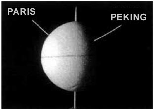
Figure 6: When the Earth turns from left to right, Beijing has just turned dark; So it's evening. However, when the Earth turns around, Beijing will soon be bright; in the city the morning is afraid. The teacher recalls the conclusions of the previous lesson and asks: "What time is it in Beijing when lunch is in Paris?" He emphasizes that the answers must be based on a model.
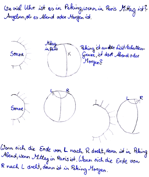
Figure 7: Considerations regarding the direction of rotation of the Earth. Students translate their models so that "lunch" is in Paris, and see what happens at that time in Beijing. They all try and then try to respond. Groups share their answers and justify them. The teacher leads the discussion. He relies on groups that have correctly identified the problem and help to conclude that the question cannot be answered until the person knows the direction of the earth.
"What time are we living in?" This question worried people for a long time.
Ptolemy III Everget - egyptian pharaoh, in 238 BC. tried to reform the calendar by introducing an extra day in every fourth year. Caius Julius Caesar in 48 BC introduced leap years. Gregory XIII is the Pope who introduced the modern calendar in 1582. Steve Fleming (Canada) in 1882 proposed introducing a standard time system, since it is inconvenient to use local time in everyday life, since it is different on each meridian. For example, on two adjacent meridians drawn in 1`, the local time differs by 4 minutes. Therefore, the time zone was adopted.
Lesson 8: In which direction does the earth revolve around itself?
From the apparent movement of the sun, students get a sense of the rotation of the earth. 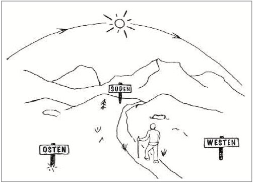
Figure 8: In Europe, an observer sees the sun moving from east to west. 
Figure 9: Close to the sun, an astronaut will see the Earth turn from west to east. The teacher recalls the result of the last lesson and the question of the time in Beijing, when it is 12 o'clock in Paris. Currently, the question is better left open and does not tell students that the key to the answer lies in the apparent movement of the sun. You can still help them later if they don't make the connection on their own.
The entire surface of the globe was divided into 24 time zones, 15 'each. For standard time taken local time the middle meridian of each belt. The zero (aka the twenty-fourth) belt is the one in the middle of which the zero (Greenwich) meridian passes. To the east of any belt, time increases, to the west, it decreases. Time zone boundaries do not always run strictly along the meridians. They are carried out taking into account the administrative boundaries, so that this or that administrative unit is in the same time zone.
You can use their models. The teacher moves from group to group and realizes that a failed attempt will not take too long. He gives the aforementioned help if he deems it necessary. The teacher conducts an exchange between groups and reviews the answers.
The teacher compares this consideration with thoughts from and draws an appropriate drawing. He also helps to conclude: "We cannot finally decide what is moving, but if it is land, we at least know that it goes from west to east." Students now know everything they need to understand time zones. They return to the question asked. Then move on to other examples.
In the middle of the twelfth belt, approximately along the 180 'meridian, there is a date line. This is a conditional line on the surface of the globe, on both sides of which the hours and minutes coincide, and the calendar dates are wrong by one day. For example, in New Year, at 00 hours 00 minutes, to the west of this line on January 1, and to the east - on December 31 of the old year. The meridian lies between the islands of Ratmanov (Russia) and Kruzenshtern (USA), but this is the invisible border separating "today" from "yesterday" and "tomorrow" from "today".
The teacher, on the one hand, recalls the unanswered question: "If it is noon in Paris, but the time is in Beijing?" - and on the other - to the problem of the Earth's rotation. Using a globe, he explains the expression "from west to east", which is commonly used to describe the direction of rotation of the earth. He puts the model on the table to help students think and reason.
Students look for an answer to the question and write it down. This should now be applied to other cities, which was understood in relation to Paris and Beijing. For simplicity, cities should be proposed that are at about the same longitude or whose longitude is about 90 degrees, which corresponds to a quarter of the earth's turn. So the answers are just four times a day: noon, midnight, night start and night end.
Crossing this conventional line, we find ourselves from one day to another. For example, the crew of the aircraft headed by Valery Chkalov flew to America from our country on June 18, 1937, flew without landing for two days, but landed in America not on June 20, but on June 19, that is, as if he returned to yesterday. For this reason, the first travelers around the world - Magellan's satellites - "lost" one day, although they carefully kept the ship's diary.
The teacher asks the students to find three new cities and mark them in their places on their balls. He points out that the model is subsequently used to answer the questions on the board.
- Midday in Lima; Which day in Sydney?
- It's daytime in Beijing; What time is it in Paris?
- Night in New York; what time of day in Lima? etc.

Figure 10: Questions and answers about the time of day in different cities. Initially, students use both flat and spherical representations of the earth. Both are required in this tutorial. If necessary, the teacher corrects questions, brings up examples he knows are difficult, and writes two sentences on the blackboard: The times in Paris and Sydney are not the same, because Paris and Sydney are not the same. Hemisphere lies. "The time in New York is the same in the northern hemisphere and in Lima in the southern hemisphere."
In our country, on February 8, 1919, standard time was introduced and 11 time zones were established throughout the territory (from II to XII inclusive). Further use of this time zone grid revealed a number of inconveniences. For example, in some regions (Ryazan, Vladimir, Voronezh, Chita) it was necessary to use different times, different by an hour, since the boundaries of the belts passed through their territory (in part, this was caused by a change in the administrative-territorial division). Sometimes it came to curiosities: the border of the time zone divided the city into two parts, this happened, for example, in Novosibirsk. Therefore, on March 1, 1957, new time zone boundaries were established in our country. There were still 11 of them, but the boundaries of the belts now fully correspond to the administrative ones, with the exception of the Krasnoyarsk Territory and Yakutia. On October 1, 1981, new refined time zone boundaries were introduced. This clarification mainly affected the unification of XI and XII time zones into one (XI). So, on the territory of our country, there were 10 time zones.
Lesson 10: How do you write down what you understand?
Students each note for themselves in their notebooks whether these two statements are true or not. The first statement is corrected and then reads: "The time is not the same in Paris and in Sydney, because Paris and Sydney are not in the same circle of longitude." Several options are offered. The idea is to represent the Earth-Sun system from the North Pole on a flat surface so that the days of the day are visible.
The teacher shows pictures from the drawing. Each student is given a time of day in three cities. They then compare their results with small groups. Use their solar model if necessary. Figure 11: Photos for photocopying and cutting. For each photo, students determine the time of day in the city. The teacher can remember the meaning of the rotation of the earth.
Since 1981, summer time has been introduced in our country. However, this was already the second daylight saving time. The first led to the introduction of daylight saving time.
Daylight saving time was "invented" in Great Britain with the aim of saving energy resources and was introduced in 1908. The clock hand for the summer period was moved 1 hour forward. Since then, many countries have begun to use a similar order of reckoning time. In Europe, this time is called summer time, and in America - ahead of time.
This time, the model shown in Figure 12 should be made. The model is then used to answer the questions, "Today in Beijing, what time of day is it in Los Angeles?" etc. the model can also be improved: the moving circle is divided into 24 sectors corresponding to 24 time zones.
Requirements for the practical implementation of the training unit
The following moments of the day should be displayed in the model. 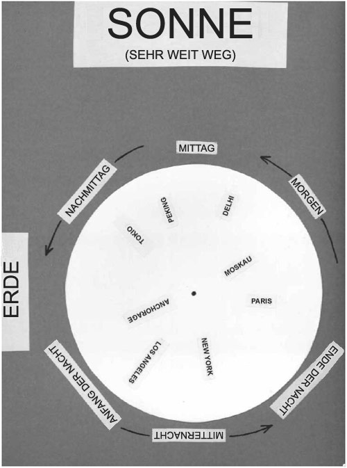
Midnight Midnight Early Night Late Night Morning Night. ... Figure 12: Cardboard model.
Student group materials
Materials for joint discussion. It takes ten lessons, each of which is 45 to 60 minutes long. This is quite a bit, but the lesson includes many curriculum topics.In Russia summer time was introduced only in 1917 by the Provisional Government. Later, for 13 years, it was annually established by its decrees of the Council of People's Commissars of the USSR. In 1930, the next summer time was extended for the winter. This is how the daylight saving time appeared. Since then, we have been living constantly 1 hour ahead of the standard time. In 1981, daylight saving time was reintroduced, but now in the summer the hour was no longer added to standard time, but to daylight saving time. Daylight saving time is introduced on the last Sunday in March, but canceled on the last Sunday in September. Since 1996, on the recommendation of the Economic Commission for Europe, daylight saving time has been canceled on the last Sunday in October. This means that in autumn and winter, our time is 1 hour ahead, and in spring and summer - by 2 hours. And we are not alone in this: a similar procedure operates in France, Belgium, the Netherlands. The economic benefits of translating arrows are obvious, but there has been a lengthy debate about how this affects people's health and biorhythms. A special commission, created from doctors and specialists in the field of chronobiology and chronomedicine, came to the conclusion that the difference between normal and summer time of 1 and even 2 hours is harmless not only for an adult, but also for a child. Full adaptation of the body occurs in 1-2 days.
Recommended information sheets
In this lesson, students have learned, in addition to acquiring knowledge, to look at things from different angles. They have what they observe and describe in geographic system of frame of reference - or even in an egocentric frame of reference - in an abstract representation. They learned to leave the center and developed their spatial orientation skills.
If, in another case, work is done on the moon, as well as experiments with models, it will be shown how the learned skills and mental images are still present and used again. Throughout this lesson, students are encouraged to reflect, exchange, and justify their opinions. They should articulate their thoughts clearly and document their explanations with texts and pictures. The working methods are varied. All of this contributes to their ability to speak and their linguistic versatility.
Types of time
Ephemeral - an independent variable in the equations of motion of celestial bodies
Starry - the duration of the day is equal to the period of rotation of the Earth around the axis relative to the system of stars
Solar - determined by the change in the hour angle of the Sun
World - mean solar time of the prime meridian
Local - time on one meridian in this moment
One of the possible extensions is universal time. It makes sense to combine time around the world so that events of global significance are clearly timed. One uses our time zone and speaks of UTC. At the end of this lesson, students associate time with the apparent movement of the sun. They learned how to use bullets and beams to create a model of an object. In this context, they can ask a range of pertinent questions that are not easy to answer. "Why is the shadow of a sundial not the shortest when our clock shows twelve noon?", "Why is the length of the day not always equal to the length of the night?"
Zone - time within one time zone
Daylight saving time plus one hour
Solution of practical problems.
Task. Determine the time in Yakutsk and Magadan, if it is 12.00 in Moscow.
Estimated answer: 18.00 and 20.00, respectively.
Task. Determine the standard time of Khabarovsk if it is 7 o'clock in Chelyabinsk.
A) Using the map of time zones, determine in which time zones the cities are located (Khabarovsk - in IX, and Chelyabinsk - in IV time zone).
The teacher can help students find answers to these questions. Of course, the lesson at the end raises unresolved issues and new issues are highly desirable. Adult scientists do not rate their daily research differently. In an effort to help students focus even more on their views, as well as on their work on the moon, night changes can be fostered on other celestial bodies: from the sun, Planet Jupiter will take care of itself in about 10 hours. How long is Jupiter's night? When looking at the sun, the moon turns in about 30 days.
B) Determine how many hours the zone time of these cities differs (9 - 4 = 5 hours).
Answer: Therefore, if it is 7 o'clock in Chelyabinsk, then the standard time of Khabarovsk is 12 hours.
so 10 + 10 = 20 hours.
Task. To how much and in what direction should the clock be moved,
time? What is the local time in Anadyr?
Estimated answer: 9 hours ahead. Will be 3.00 hours 31
Determine when Moscow time should land
in Moscow (II time zone) a plane taking off from Krasnoyarsk (VI time zone)
zone) at 17:00 Krasnoyarsk time. Estimated flight time is
4 hours. Write down the answer in numbers.
Answer: __________________ h.
Determine when, according to Moscow time, the plane that took off from Chita (VIII time zone) should land in Moscow (time zone II) at 7 o'clock local time, if the estimated flight time is 8 hours. Write down the answer in numbers.
Answer: _________________ h.
In accordance with the Law "On the Calculation of Time" and the decree of the Government of the Russian Federation, since September 2011, 9 time zones have been established on the territory of the country (see map).
The plane took off from St. Petersburg (II time zone) to Orenburg (III time zone) at 9 o'clock Moscow time. The estimated flight time is 3 hours. How long will it be in Orenburg when the plane lands? Write down the answer in numbers.
Answer: ___________________________.
![]()
The topic “Lithosphere. Rocks and minerals "
Concepts under consideration: lithosphere, rocks, types of rocks, minerals.
Lithosphere - the stone shell of the Earth, includes earth crust and the top of the mantle).
The mantle is around the core and makes up the bulk of the Earth. Its capacity is up to 2900 km. Temperature up to 2500 degrees. Consists of heavy minerals containing iron. The material of the mantle is in a solid state, except for the soft outer part.
Earth's crust. The outer shell of the Earth consists of various rocks. Consists of three layers: sedimentary, granite, basalt. The thickness of the Earth's crust under the oceans is from 5 to 10 km, 35-45 km on land and up to 75 km in mountainous regions.
Rocks are the substances that make up the earth's crust.
Minerals are natural bodies, homogeneous in composition and properties, formed in the depths and on the surface of the Earth. For example, granite consists of: quartz, feldspar, mica. Several thousand types of minerals and rocks are known in nature. Minerals are homogeneous. Rocks are more complex in structure.
Both of them differ in structure, hardness, density, color, gloss, melting point and other properties.
The main reason for this is the differences in the conditions of their formation and the changes that occur with it in the earth's crust and on its surface.
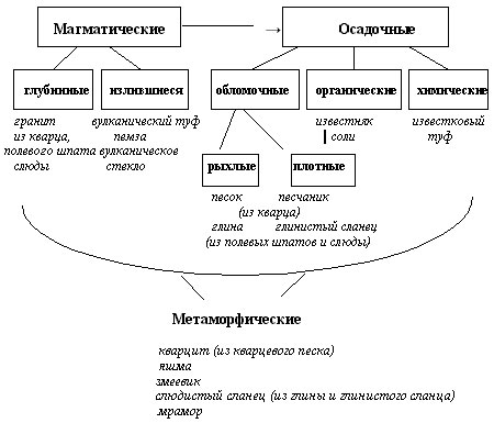
By their origin, rocks and minerals can be divided into igneous, sedimentary, and metamorphic.
Igneous rocks were formed as a result of the solidification of magma on the surface and in the depths of the Earth.
Deep:
Formed from magma deep in the earth's crust.
The solidification of magma at depth is slow.
Large crystals are formed due to the slow cooling. They are clearly visible in the breed.
The rocks are crystalline and dense.
Outpouring:
Formed from magma in cracks and faults in the earth's crust.
The solidification of magma at depth occurs quickly.
Crystals are small, difficult to distinguish with the naked eye.
Rocks are dense, hard, heavy.
Sedimentary rocks are formed on the Earth's surface as a result of the deposition of rock debris in water and on land.
Sedimentary clastic rocks are formed under the influence of:
flowing waters,
temperature fluctuations
and other influences, rocks are destroyed.
This is how pebbles, gravel, sand are formed.
Sedimentary chemical origin is formed from aqueous solutions of mineral substances.
Organic sedimentary origin is formed from the remains of plants and animals that have accumulated on the bottom of the seas and oceans. They are characterized by layering. Over the millennia, the layers were compacted, turning into denser rocks: sandstones, limestones.
Metamorphic rocks are any rocks that have undergone significant changes under the influence of high temperatures and pressure.
Limestone - marble,
Sandstone - quartzite,
Granite - gneiss
Sample assignments for the exam on this topic:
Which of the listed rocks is metamorphic
origin?
1) sandstone
3) limestone
The topic “Lithosphere. The main forms of relief "
Concepts under consideration: mountains, plains, continents, oceans.
Basic landforms the earth's surface can be flat, convex (hill, mountain), concave (hollow, mountain valley, ravine), etc. The largest parts of the earth's crust - continental and oceanic - differ markedly from each other. Their relief is extremely varied. But both on land and at the bottom of the Ocean, two main forms stand out: mountains and vast flat areas. The main reason for the diversity of the relief of the earth's crust is the interaction of internal processes that create large irregularities, and external ones, aimed at leveling the surface.
The outer shell of the Earth - the lithosphere - is closely connected with its inner shells, including the Earth's mantle. First, the lithosphere was formed from the material of the mantle. Secondly, it is mobile and this movement is determined by the movement of the material of the mantle. Thirdly, as a result of such a movement in its most active areas, mountains, oceanic depressions, island arcs arise, i.e. relief of the Earth. Fourthly, the emergence of the Earth's relief is accompanied by the phenomena of volcanism and earthquakes. Even such a superficial acquaintance with the inner forces of the Earth suggests that they are grandiose. It is the inner forces of the Earth that have shaped and are shaping the face of our planet. Where do these forces come from? This is mainly the result of the decay of radioactive elements that make up the core of the Earth.
The most powerful changes in the Earth's relief are associated with its internal forces.
Continents and oceans are the main landforms of the Earth. Their formation is due to cosmic and planetary processes that took place in different historical periods.
In the formation of the Earth's relief, deep faults, cutting through the entire earth's crust, play a huge role. We already know that such faults divide the lithosphere into separate blocks, forming, as it were, a mosaic of blocks (plates) of different sizes. The most active areas of the lithosphere are located at the boundaries of these plates. The further we move from the boundaries of the moving sections to the center of the plate, the more calm the sections of the lithosphere become.
The continents are the largest massifs of the earth's crust, which have a three-layer structure. Most of their surface protrudes above the level of the World Ocean. In the modern historical period, there are six continents: Eurasia, Africa, North America, South America, Australia, Antarctica.
The World Ocean is a continuous body of water that surrounds the continents. The oceans are divided by continents into four oceans: Pacific, Atlantic, Indian and Arctic.
Which is more: land or the oceans? To answer this question, just look at a map or globe. Land accounts for only 29% of the Earth's area. Everything else is the World Ocean.
The continents and oceans of the Earth, like everything on our planet, constantly interact with each other.
Mountains and plains, as well as continents and oceans, are the main landforms of the Earth. The mountains are formed as a result of the activity of the internal forces of the Earth, and the plains - as a result of the destruction of mountains.
Plains are large areas with flat or hilly surfaces.
Mountains - areas of the earth's surface, elevated above sea level to a height of more than 500 m. Mountains and plains are located both on the continents and in the oceans. Both on land and in the ocean, the plains are located, as a rule, in calm areas of the lithosphere, and the mountains - in active ones.
The relief is depicted on the map using layer-by-layer coloring, i.e. color (green and brown) of varying intensity. Areas with heights from 0 to 200 m are painted green, and from 200 to 500 in light brown, etc. At the bottom of the map there is a table from which you can see which color corresponds to which height.
Mountains and land plains are well studied by man. It is known that mountains occupy about 40% of the Earth's land mass. However, the main population of the Earth lives on the plains.
The nature of the plains has been greatly modified by man. Agriculture and cattle breeding are developed on the developed lands. The plains are home to large cities and industrial areas. Plain rivers are used for navigation, power generation, drinking and industrial water, and irrigation of agricultural lands. The plains are rich in oil, gas, coal and peat.
Iron, lead, zinc, manganese and copper ores are mined in mountainous regions. Man aspires to the mountains in order to relax. There is a healthy climate in the mountains, pure water and beautiful nature. For some 1.5 hours of ascent, you can see all the natural zones of the Earth. Uses man and the energy of mountain rivers. Imagine the strength of mountain streams that rush down the steep slopes.
Sample assignments for the exam on this topic:
1. On which continent are the Appalachian mountains located?
1) Australia
2) North America
3) South America
4) Eurasia
2. Which of the listed mountain systems of Eurasia is the highest?
1) Alps 2) Tibet 3) Altai 4) Caucasus
Soil theme
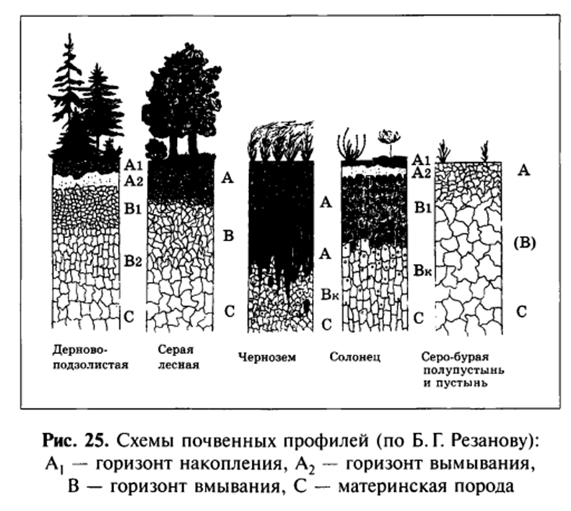
Considered concepts: soil, soil types, soil geography.
Soil is the surface layer of the earth's crust, inhabited by organisms, containing organic matter and having fertility. It is one of the important components of any natural complex.
Fertility is the ability of the soil to meet the needs of plants for nutrients and water and provide a crop, due to a combination of certain physical, chemical and biological properties.
Fertility is the most important property of the soil. It largely depends on the presence of organic matter in it - humus. Humus is formed by decomposed remains of dead plants and animals. The thickness of this layer in the soil is different: from 5 cm in the tundra to 1.8 m in the steppe chernozems of the South of Russia.
Soil is a natural body, but in the process of cultivating and cultivating it, it becomes a product of labor.
A person can, to a certain extent, influence natural fertility. Soils, modified by economic activities aimed at increasing their fertility, are called cultivated (from Latin cultura - processing, care). By introducing nutrients, improving the structure and composition of the soil, activating the biological activity of microorganisms, etc., man has learned to give the soil new properties necessary for the cultivation of certain crops. With the introduction of scientifically grounded crop rotations and soil cultivation systems that meet local conditions, the use of organic and mineral fertilizers, the creation of special forest belts in the fields to preserve moisture and protect against water and wind erosion, soil fertility can not only be preserved, but also increased.
The founder of the theory of soil VV Dokuchaev published in 1883 the book "Russian Chernozem", in which he not only revealed the origin of chernozems, their properties and geography, but also showed that the soil is a special natural-historical body formed as a result of the total activity of 5 factors of soil formation: parent rock, plant and animal organisms, climate, terrain and soil age. Thus, he formulated the law of soil zoning. Where there is little rainfall and sparse vegetation, the soil layer is thin and contains little humus. On the contrary, in places with sufficient heat, precipitation and rich, herbaceous vegetation, more powerful fertile soils are formed. Therefore, the soils on the globe change naturally from the equator to the poles (see the atlas map).
Equatorial forest soils are formed in humid and hot climates. The parent rocks (the base on which the soil layer is formed) are rich in iron compounds and therefore are red in color. The soils formed on these rocks also acquire a reddish tint. Since the soils of the equatorial forests are rich in iron and aluminum, they are called red-yellow ferralite.
In the savannah, due to a lack of moisture, the vital activity of microorganisms slows down and the plant fall of the rich vegetation cover does not decompose completely. Therefore, humus accumulates in the soil. Red-brown soils are formed here.
In the steppes temperate zone in conditions of hot and dry summers, dry and relatively cold winters, fertile chernozems prevail.
Podzolic soils prevail in the taiga zone. They form in wet and cool summers; due to low temperatures, insignificant plant litter decomposes slowly and gives a small amount of humus. Under it lies a whitish layer with insoluble particles of rock, reminiscent of ash in color. For the color of this horizon, such soils are called podzolic.
In the formation of sod-podzolic soils mixed forests involved not only woody vegetation, but also herbaceous.
Gray forest soils under deciduous forests contain more humus than taiga and mixed forest soils. The leading soil-forming process in gray forest soils is humus accumulation.
In the tundra, under conditions of cold summer and permafrost, tundra-gley soils are formed, in which plant residues decompose slowly. In addition, the permafrost layer prevents moisture seepage, which leads to waterlogging of the soil.
So, many factors affect the formation of the soil:
The properties of the parent rock, which determine the physical properties of the soil and its initial nutrient content;
Climate (affects the nature of weathering of rocks, the intensity of soil formation processes, the nature of vegetation and fauna);
Vegetation (determines the amount and composition of plant litter, which then turns into humus; extracts nutrients from the soil, loosens it, prevents the soil from surface washout and erosion);
Animals and microorganisms (affect the decomposition of litter and the formation of humus, loosen the soil).
As a result of the process of soil formation, the soil layer is divided into horizons.
Soil horizons are layers of soil that differ in color, composition, density and other properties.
The humus horizon (or accumulation horizon) is permeated with roots, dead ground and underground parts of plants; it contains many microorganisms, worms, larvae, and insects. Here, organic matter accumulates and humus (humus) is formed. It is present in all soils, but its thickness and humus content are different. The amount of humus decreases from top to bottom, because of this, the color of the horizon changes: it becomes lighter with depth
The leaching horizon is formed in soils under conditions of high precipitation. Water seeping from above carries humus particles, iron oxides, etc. from the soil horizon. The horizon is usually light gray, reminiscent of ash; poor in nutrients.
The wash-in horizon is a horizon in which substances removed from the upper horizons accumulate - iron oxides, clay particles, etc.; It is usually colored brown; in forests and forest-steppe, it is often whitish due to the high content of calcite.
Below the soil horizons is the parent rock, which is slightly affected by the process of soil formation. The soil horizons together form the so-called. soil profile - a vertical section of the soil from the surface to the parent rock. Each soil type has its own soil profile.
Soil fertility changes significantly during operation and directly depends on the correct organization of crop rotations, the use of fertilizers, amelioration systems, and soil protection from erosion and salinization. The main problem of the world land fund is the problem of agricultural land degradation. Degradation is understood as the depletion of soil fertility, soil erosion, soil pollution, a decrease in the biological productivity of pastures, salinization and waterlogging of irrigated areas, as well as the alienation of land for the needs of housing, industrial and transport construction.
One of the main causes of soil degradation is soil erosion, that is, the destruction of soil by water and wind (25 to 30% of arable land). Depending on the factors causing soil erosion, a distinction is made between water and wind erosion. Measures to combat water erosion are, first of all, the correct system of crop rotation, the creation of protective forest plantations and hydraulic structures. In land management, small fields are designed, elongated across the slope, in addition, snow retention, plowing with soil deepening and other anti-erosion measures are carried out. To combat wind erosion, plowing of land is carried out perpendicular to the prevailing winds, non-moldboard tillage is used, and forest shelter belts are planted.
Among the anthropogenic causes of soil degradation, let us name, first of all, deforestation, unrestricted grazing of livestock, and the spread of monocultures. An important place in the security system land resources occupies the reclamation (restoration) of lands disturbed by human economic activity. These are lands disturbed due to peat mining, open pit mining, irrigation construction, etc.
Sample assignments for the exam on this topic:
1. Podzolic soils are formed in
1) taiga 2) steppes 3) semi-deserts 4) tundra
2. What soils are typical for taiga forests?
1) podzolic 2) sod-podzolic 3) brown forest 4) gray forest
3. For which natural area are chernozem soils typical?
1) mixed forests 2) steppes 3) taiga 4) deciduous forests
Full text search:
Home> Examination> Astronomy
Time measurement
It is not easy to answer the question “what is time”. In the very general view we can say that time is a continuous series of phenomena replacing each other. The main property of time is that it lasts, flows non-stop. Space can be fenced off, but time cannot be stopped. Time is irreversible - traveling in a time machine into the past is impossible. “You cannot enter the same river twice,” said Heraclitus.
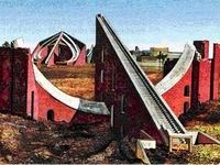
The majestic Stonehenge is one of the oldest astronomical observatories, built five thousand years ago in southern England.
The day is divided into 24 hours, and every hour is divided into 60 minutes. Thousands of years ago, people noticed that much in nature repeats itself: the sun rises in the east and sets in the west, summer replaces winter and vice versa. It was then that the first units of time appeared - day, month and year. With the help of the simplest astronomical instruments, it was found that there are about 360 days in a year, and in about 30 days, the silhouette of the moon goes through a cycle from one full moon to the next. Therefore, the Chaldean sages adopted the sixtiesimal number system as a basis: the day was divided into 12 night and 12 day hours, the circle - by 360 degrees. Every hour and every degree was divided by 60 minutes, and every minute by 60 seconds. However, subsequent more accurate measurements have hopelessly spoiled this perfection. It turned out that the Earth is doing full turn around the Sun in 365 days 5 hours 48 minutes and 46 seconds. The moon, on the other hand, takes from 29.25 to 29.85 days to go around the Earth.

Select any star and fix its position in the sky. In the same place, the star will appear in a day, more precisely in 23 hours 56 minutes. Days measured relative to distant stars are called stellar days (to be absolutely precise, a sidereal day is the time interval between two successive upper climaxes of the vernal equinox). Where do the 4 more minutes go? The fact is that due to the movement of the Earth around the Sun, it shifts for an earthly observer against the background of stars by 1 ° per day. To "catch up" with it, the Earth needs these 4 minutes. Days associated with the apparent movement of the Sun around the Earth are called solar days. They begin at the moment of the lower culmination of the Sun at this meridian (i.e. at midnight). Solar days are not the same - due to the eccentricity of the earth's orbit, in winter in the northern hemisphere, a day lasts a little longer than in summer, and in the southern hemisphere, on the contrary. In addition, the plane of the ecliptic is tilted to the plane of the earth's equator. Therefore, an average solar day of 24 hours was introduced.
Due to the movement of the Earth around the Sun, it shifts for the terrestrial observer against the background of stars by 1 ° per day. It takes 4 minutes before the Earth "catches up" with him. So, the Earth makes one revolution around its axis in 23 hours 56 minutes. 24 hours - the average solar day - the time of the Earth's revolution relative to the center of the Sun.

The prime meridian passes through the Greenwich Observatory, located near London. A person lives and works according to the sundial. On the other hand, astronomers need sidereal time to organize their observations. Each locality has its own solar and its own sidereal time. In cities located on the same meridian, it is the same, but when moving along the parallel, it will change. Local time is convenient for everyday life - it is associated with the alternation of day and night in a given area. However, many services, such as transport, must operate at the same time; so, all trains in Russia run according to Moscow time. To avoid confusion, the concept of Greenwich Time (UT) was introduced: this is the local time at the prime meridian, on which the Greenwich Observatory is located. But Russians find it inconvenient to live at the same time as Londoners; this is how the idea of standard time appeared. 24 Earth meridians were selected (every 15 degrees). At each of these meridians, time differs from the universal one by an integer number of hours, and minutes and seconds coincide with Greenwich. 7.5 ° in both directions was measured from each of these meridians and the boundaries of time zones were drawn. Within time zones, time is the same everywhere. In order to separate settlements did not find themselves in two time zones at once, the boundaries between the zones shifted slightly: they are drawn along the borders of states and regions. In our country, standard time was introduced on July 1, 1919. In 1930, in the territory of the former Soviet Union, all clocks were set forward one hour. This is how the daylight saving time appeared. And in March, the Russians move their clocks one hour ahead (i.e. already 2 hours in comparison with the zone) and live according to summer time until the end of October. This practice is adopted in many European countries.
Time zones of the Earth
According to Moscow winter time, true noon in Moscow comes at 12:30, summer time - at 13:30. Returning from the first voyage around the world, the expedition of Fernand Magellan found out that they had been lost for a whole day: by ship time it was Wednesday, and the locals, all as one, claimed that it was already Thursday. There is no mistake in this - the travelers sailed west all the time, catching up with the Sun, and, as a result, saved 24 hours. A similar story happened to Russian explorers who met the British and French in Alaska. To solve this problem, an international date line agreement was adopted. It passes through the Bering Strait along the 180th meridian. On the island of Kruzenshtern, lying to the east, according to the calendar, one day less than on the island of Rotmanov, lying to the west of this line.
The ancient Indian observatory in Delhi, which also served as a sundial.
Our calendar and our time are adjusted to the Sun and the Moon, but these luminaries are not suitable for accurate measurement of time: the Earth and the Moon move unevenly in their orbits, the speed of rotation of the Earth, in addition, gradually decreases under the influence of tides. And it is all the more inconvenient to measure short periods of time by luminaries - minutes and seconds. Since ancient times, hourglass and water clocks have been used to more accurately measure time, and in the 11th century the first mechanical watches appeared, but their time had to be checked several times a day with the sundial. In the middle of the 17th century, having discovered the law of oscillation of the pendulum, Galileo Galilei brought mechanical watches to a new level of precision. However, even the best mechanical watches do not show the exact time: they are in a hurry or lag behind due to inaccurate adjustment, vibration, temperature changes, and some external influences. In 1939, astronomers replaced mechanical pendulum clocks with quartz ones: the accuracy increased hundreds of times and became 10–4–10–6 s per day. And twenty years later, the atomic clock appeared; the deviation of their course is only 10–10–10–11 s.
Sundial and sidereal clock
Sundial
Humanity has been counting time by the sundial since time immemorial. It is difficult to say who and when first suggested using the Sun (and its shadow) as an hour hand. One thing is obvious - this invention was brilliant! That is why even now - in the age of ultra-precise mechanics, electronics and nuclear particles - it is very useful for amateurs of astronomy to make at least the simplest sundial, the arrow of which will serve as a shadow from the star closest to us ...
As you know, there are three main types of sundials: equatorial, vertical and horizontal. The equatorial clock is the simplest. The plane of their dial lies in the plane of the celestial equator (that is, it is located at an angle (90 ° - f), where f is geographic latitude). The dial itself is divided into equal angles at the rate of 1 hour = 15 °. Any "pin" fixed in the center of the watch perpendicular to its plane can serve as a pointer. Making an equatorial sundial is easy, but in the northern hemisphere it will only work when the declination of the sun is positive (from the vernal equinox to the autumn equinox). In winter, you have to use the lower part of the dial, which is very inconvenient.
The vertical watch is much more elegant. But there are also several "pitfalls" here. First, their mathematical model is quite complex. Secondly, (and this is the main thing!) To make a vertical sundial, you need to accurately measure the azimuth of the building wall where they will be attached. Of course, all difficulties are surmountable, but at the first stage, I would advise you to make your own horizontal sundial, which successfully combines accuracy, efficiency and simplicity. Such watches can have different sizes: from portable (10-20 cm in diameter) to stationary (1-2 meters or more). So, a horizontal sundial consists of two parts: 1) a dial located in the horizon plane; 2) a pointer casting a shadow, which in the simplest case is a triangle, one of the corners of which is equal to the geographical latitude of the installation site. The plane of the pointer lies in the plane of the celestial meridian (that is, it is located in the north-south direction). In this case, the angle of the triangle, equal to the latitude of the place, should point to the north (pole of the world), and the lines of hours (and minutes) on the dial should, as it were, fan out from south point the base of the pointer. Now about the graduation of the dial. If we want our horizontal sundial to "show" the same time as an ordinary clock, we proceed as follows.
1) We calculate the moment of true noon. This is easy to do using the formula:
T (floor) = 12 + h-L + n + 1, where
T (floor) - moment of true noon, h - equation of time (difference between mean solar and true solar time), L - geographic longitude(expressed in hourly units), n - time zone number, 1 - correction for daylight saving time. In the summer, you will have to add one more hour (due to the transition to "summer time"). As for the equation of time, then, in principle, it can be neglected, since during the year it varies from -16 minutes (about November 2) to +14 minutes (about February 11), turning to zero near April 15, June 14, 1 September and 24 December. Well, if you want to make a super accurate sundial, then you have to calculate several dials and change them as the equation of time changes.
For example, for Vologda in the summer (L = 2h 40m, h = 0, n = 3) we have:
T (floor) = 12 + 0 - (2h 40m) + 3 + 1 = 13h 20m It is at this moment that the Sun is exactly in the south and, accordingly, casts a shadow from the pointer to the north (N in the figure). This means that at noon our watch should show 13h 20m. (During winter time - 12h 20m).
2) Digitizing the dial. We will arm ourselves with a calculator and use the following formula: tg (a) = sin (f) * tg (t), where a are the angles at which the dial will be drawn, f is the latitude, t is the time interval, expressed, of course, in degree ( based on 1h = 15 °). For example, we want to know at what angular distance from the north direction the 13 o'clock position will be. It's easy to figure out that instead of t, you need to substitute 20 minutes, expressed in degrees and their fractions. (To do this, divide 20 by 60 and multiply by 15). After calculations (substituting the exact latitude values for Vologda), we get 4.4 °. It is this angle that needs to be postponed from the north direction counterclockwise. After all the calculations, we get a table (negative angles for a indicate that they should be set aside on the dial clockwise). Of course, you shouldn't calculate data for the night ...
The dial, drawn according to the above calculations, can be seen in the figure. For a small horizontal sundial (about 15 cm in diameter), the hour markings are quite sufficient, since the minutes are easy to estimate by eye, looking at the shadow of the pointer. Larger watches will require additional calculations of minutes (or at least quarter hour marks) - this can also be done using the above formula.
t 22h 21h 20h 19h 18h 17h
a -134.2 ° -118.4 ° -101.5 ° -84.1 ° -66.9 ° -50.7 °
t 16h 15h 14h 13h 12h 11h
a -35.7 ° -21.7 ° -8.5 ° 4.4 ° 17.5 ° 31.1 °
t 10h 9h 8h 7h 6h 5h
a 45.8 ° 61.6 ° 78.5 ° 95.9 ° 113.1 ° 129.3 °
Do not forget that during the winter time period, the numerical values of the hours should be reduced by one. For example, instead of "13 hours" we get "12", instead of "14" - "13" and so on. By the way, a portable horizontal sundial can be used as a compass. To do this, according to the usual clock, we set our sundial at the right time: then the triangular pointer will show the north-south direction, and the north will be where the marks "12" and "13" are drawn.
Star Clock
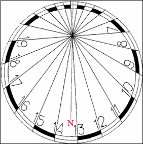
If on a clear day the time can be counted according to the Sun, then what about at night? Right! The stars will help us! For a true fan of astronomy, it will not be difficult to determine the time by the characteristic arrangement of the stars in a particular season of the year. But it's easier to find out what time it is now by the orientation of the constellation Ursa Major. Moreover, in cloudless weather in the middle and northern latitudes, the "Sky Bucket" never sinks under the horizon. Imagine a huge celestial dial with the North Star in the center. Then the constellation Ursa Major will become a giant cosmic arrow.
Please note (see Fig.) That our dial is not divided by 12 o'clock (as in a regular watch), but by 24 hours. In this case, the "0h" mark is above the north point, the "12h" mark is on the other side of the North Star. The values "6h" and "18h" are respectively located in the east and west directions. In other words, the course of time in the sidereal clock is counted counterclockwise, since this is how the Ursa Major "rotates", as, indeed, all the other circumpolar constellations. Further. We draw a straight line from the Pole Star to the stars "Delta" (Megrets) and "Gamma" (Fekda), decorating the left side of the Big Dipper Bucket (see fig). The arrow will point to the point of the autumnal equinox. (It is easy to guess that the vernal equinox will be in the diametrically opposite direction, in which, alas, there are no stars of the Big Dipper).
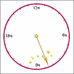
Then the numbers on our imaginary heavenly dial will show the so-called sidereal time (the hour angle of the vernal equinox). So, in the figure, the sidereal time turned out to be approximately 1 h 30 m.It is known from spherical astronomy that sidereal time (S) is equal to the sum of right ascension (RA) of a celestial object (for example, a star, the Moon, the Sun ...) and its hour angle (t).
Since we already know the sidereal time, by somehow recognizing the right ascension of the Sun, we will be able to calculate its hour angle (t = S - R.A.). Adding 12 hours to this result, we get the local solar time. (After that, you can go to the standard time). But how to find out the right ascension of the Sun ??? Of course, you can use astronomical calendars, where the equatorial coordinates of the Sun are given for each day. Better, however, to "calculate" this information yourself - the astronomical yearbook is not always at hand! In fact, if you do not chase super precision, then it is not difficult to find out the right ascension of the Sun for any date.
You just need to remember that on March 21 (on the day of the vernal equinox) the right ascension of the Sun is 0 h, on June 22 (summer solstice) - 6 h, September 23 (autumn equinox) - 12 h and December 22 (winter solstice) - 18 h. Also, remember that right ascension of the Sun increases by about 4 minutes per day.
So, let's say we looked at the sidereal clock and found sidereal time equal to 1h 30m. Suppose we conduct observations on, say, October 1st. 8 days have passed since the autumnal equinox and R.A. The Sun has increased by 8 x 4 = 32 minutes and is 12 h 32 m. The found value, of course, will be rounded to 12 h 30 m.We find the hour angle of the Sun t = 1h 30m - 12h 30m = 25h 30m - 12h 30m = 13h 00m
This means (we add 12 hours), the local solar time is 25 h 00 m (or 1 h 00 m). Suppose we are observing in Vologda. The longitude of this city is 2 h 40 m. Subtract from 25 h 00 m 2 h 40 m, we get 22 h 20 m - this is exactly what universal time is at the moment. We turn to standard time (add 3 hours) and here it is, the long-awaited result: now 1 h 20 m! We check on a moving map of the starry sky and make sure that we are not mistaken ...
Accurate time and definition of geographic longitude.
The sun always illuminates only half of the globe: on one hemisphere it is day, and on the other at this time it is night, respectively, there are always points where it is at noon at the moment, and the sun is in the upper climax. As the Earth rotates on its axis, noon occurs in those places that lie to the west. The position of the Sun (or stars) in the sky is used to determine the local time for any point on the globe. The local time at two points (T1 and T2) differs exactly as much as their geographic longitude differs:
T1-T2 = L1- L2.
It is clear that noon occurs at a given point on the Earth later than at another, exactly as long as the time it takes for the planet to turn by an angle corresponding to the difference in their longitudes. So, for example, in St. Petersburg, which is 8 ° 45 "west of Moscow, noon occurs 35 minutes later. Having determined from observations the local time at a given point and comparing it with the local time of another, the geographical longitude of which is known, it is possible to calculate the geographical longitude of the observation point. We agreed to count the longitude from the initial (zero) meridian passing through the Greenwich Observatory. The local time of this meridian is called universal time - Universal Time (UT). Then T1 = UT + L1, in other words, the local time of any point is equal to universal time at this moment, plus the longitude of this point from the initial meridian, expressed in hourly measure.Accurate timing is complicated by the fact that its previous standard - the period of the Earth's rotation - turned out to be not entirely reliable. which passes from one upper climax of the Sun to the other. But as the accuracy increases, the astronomer It became obvious from historical observations that the length of the day does not remain constant.
The speed of rotation of our planet changes throughout the year, and in addition, there is, albeit very slowly, a slowdown in its rotation. Therefore, it is clear that the definition of a second as a unit of time, constituting 1/86 400 of a day, required clarification. You know the modern definition of a second from a physics course. The use of atomic clocks, which are at the disposal of the precision time services and the state standard of time and frequency, provides an extremely small error in time counting (about 5 10-9 s per day). The exact time signals broadcast by radio are transmitted precisely from the atomic clock. By receiving these signals and determining the local time from observations of the moments of the climax of the stars, it is possible to calculate the exact coordinates of any point on the earth's surface. These points serve as reference points for mapping, laying gas pipelines, roads and railways, building large facilities and a number of other works.
Precise time signals, along with other means (radio beacons, navigation satellites, etc.), are necessary in aviation and maritime navigation. If in our daily life we used local time, then as we move to the west or east, we would have to continuously move the hands of the clock. The inconveniences arising from this are so obvious that at present, almost the entire population of the world uses standard time. The belt system of time counting was proposed in 1884. According to this system, the entire Earth was divided in longitude into 24 time zones (according to the number of hours in a day), each of which occupies approximately 15 °. As a matter of fact, time is counted according to this system only on 24 main meridians, spaced 15 ° from each other in longitude. The time on these meridians, which are located approximately in the middle of each time zone, differs by exactly one hour. The local time of the main meridian of this zone is called standard time. It keeps track of time throughout the territory belonging to this time zone. Zone time, which is accepted at a particular point, differs from the world one by the number of hours equal to the number of its time zone:
where UT is the universal time and n is the time zone number.
The boundaries of time zones are lines that run from the North Pole of the Earth to the South Pole and are approximately 7.5 ° from the main meridians. These boundaries do not always run strictly along the meridians, but are drawn along the administrative boundaries of regions or other regions so that the same time operates throughout their territory. It is natural, for example, that Moscow lives according to the time of one (second) time zone. If we formally follow the accepted rule of division into time zones, then it would be necessary to draw the border of the zone so that the city would be divided into two unequal parts.
In our country, standard time was introduced on July 1, 1919. Since then, the boundaries of time zones have been revised and changed several times. Since January 1992, when the clocks in Russia were moved forward one hour, we have been living according to the so-called daylight saving time, which was introduced in the USSR back in 1930. At the end of March, the country switches to daylight saving time, the clock hands are shifted to one more an hour ahead. Daylight saving time is canceled at the end of September, the hands are returned one hour back. The days when daylight saving time is introduced and canceled are established annually by government decree. Moscow Daylight Savings Time, which is shown by the clock not only in Moscow, but also in St. Petersburg and the central regions of Russia, differs from universal time by 3 hours in winter and 4 hours in summer.
Indirect. Then, neglecting the error ... the random error measurements time, that is...