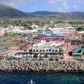
Itum-Kale- a village, a regional center in the Republic of Chechnya; located in the valley of the Argun river. It is translated from Chechen as “settlement of Eton”. The Vainakh name of the village is Eaton-Khelli. In the old days, there were many battle and residential towers here; on the eastern outskirts of the village there is a burial ground of the pagan period (Phyakochura keshnash)
This dictionary entry describes how the origin of the name can be explained or translated into Russian Itum-Kale... This decoding (explanation) of this toponym is given according to the book by A.V. Solid "Toponymic Dictionary of the Caucasus".
There are possible, and even likely to be, typos and inaccuracies caused by both scanning and post-processing. Alone all of them "catch" the strength is not enough, but you can - I will correct. Also, due to the fact that this collection of dictionary entries contains books by several authors, different interpretations of the same name are possible - this is normal - the truth is born in a dispute. I would be grateful for the additions, clarifications and other works on toponymy sent
Comments:
Message from: pobeda202010Itum-kale, translated from the Turkic ITUM-dog, Kale-city. when the great conqueror Timur came to the Caucasus, the mountaineers of this settlement resisted for a long time and did not surrender, then he ordered to demolish this ITUM-kale "Dog's city"
Message from: Borz
Hya nen bud boo Fucking bitch dog. Itum-Kale means Eton-Khal "the village of Eton".
Message from: Galga
IT is 10
UM community (religious)
KHELLA-spawned.
ITUM-KALA - 10 communities (virds) that gave birth to.
Phyakochura keshnash
N (pu) offspring
AK-Idolno AKOCH-Idols
URA (OPA) -ORDAN (OR-GA river ARGUN, literally-ORDAN tree)
KESHNASH-graves
About ITUM - a dog. ITILIAN communities (Volga communities) Türks called "dog", however, like GA-URY or GYA-ORY literally - "ORDAN tree")
Message from: Said
The word Kale in translation from the Turkic means a castle (fortress)
Assalam Aleikum!
I bring to your attention the photos taken during a trip along the mountain route Grozny-> Shatoi-> Itum-Kali-> Khacharoi-> I lead chi. It is along this route (as conceived by the organizers of the construction of the Veduchi ski resort) tourists who will not be able to afford a helicopter will pass by :-)
Before reaching Shatoi, on the side of the road, springs with spring water that are unlike each other in taste are gushing in a row. The most popular and delicious water flows from this spring:
Shatoi did not take pictures, since you saw his panorama in previous posts, so I will immediately turn to Itum-Kali:
Itum-Kali is mainly inhabited by representatives of the Ch1antiy teip, who are distinguished by their tall stature, red hair and light eye color. On the southern outskirts of the village are the ancient ruins of the old aul. Since 1967, the Argun Historical and Archaeological Museum-Reserve has been operating here. At the beginning of April 2011, in the entire history of the existence of this mountain village, gas was supplied here. Natives of Itum-Kali are: Hero of Russia Magomed Uzuev (his name is the border post stationed here), who died together with A-Kh. Kadyrov Khusein Isaev, Chairman of the State Council of Chechnya, as well as Russian banker Abubakar Arsamakov
From Itum-Kali, upstream of the Orga (Argun) river, there is a road to Georgia, which was actively built under Maskhadov and which has now been frozen (part of the "Georgian" road is visible on the right):
We took to the left of the Georgian road and went up:
Towards Veduchi:
Veduchi, a small mountain village belonging to the numerous teip Khachara (Khacharoi), from which they come from: businessman: Ruslan Baysarov, the mayor of Grozny Muslim Khuchiev and my friend and just a good guy Alan Magomadov :-). As we saw, in Veduchi itself, the construction of a $ 500 million ski resort is not being carried out, but according to the words of local residents, the construction is going "in-there!":
As I later understood the construction will go from the other side.
Pay attention to the ruins of a village with a tower standing by the cliff, where people somehow restored their dwellings and live in them:
It is very difficult to live in the mountains, there is practically no money and people get their own food thanks to: beekeeping (excellent honey), maintenance of subsidiary farming, cattle breeding. But you forget about all the difficulties when you see such beauty around you, clean air and amazing spring water from glaciers:
Those who have the opportunity to build houses on their ancestral lands using natural stone:
At the very end of geography there are the ruins of the village of Ati-Bov (Ati-B1ovda) this is the small homeland of the Chechen blogger wild_che
At this point the journey was over, the next trip was planned to Hildehara and Shara ...
P.S. I ask professionals not to judge strictly for the quality of the photos, the photos are for informational purposes only. (
The sun is the source of life on the planet. Its rays provide the necessary light and warmth. At the same time, the ultraviolet radiation of the Sun is detrimental to all living things. To find a compromise between the beneficial and harmful properties of the sun, meteorologists calculate the index of ultraviolet radiation, which characterizes the degree of its danger.
What UV radiation from the Sun is
Ultraviolet radiation from the Sun has a wide range and is subdivided into three regions, two of which reach the Earth.
-
UV-A. Long-wavelength radiation range
315-400 nmThe rays pass almost freely through all atmospheric "barriers" and reach the Earth.
-
UV-B. Medium wavelength range
280-315 nmThe rays are 90% absorbed by the ozone layer, carbon dioxide and water vapor.
-
UV-C. Shortwave range radiation
100-280 nmThe most dangerous area. They are completely absorbed by stratospheric ozone before reaching the Earth.
The more ozone, clouds and aerosols in the atmosphere, the less the harmful effects of the Sun. However, these saving factors have a high natural variability. The annual maximum of stratospheric ozone is in the spring, and the minimum is in the fall. Cloudiness is one of the most variable characteristics of weather. The carbon dioxide content also changes all the time.
At what values of the UV index is there a danger
The UV Index gives an estimate of the amount of UV radiation from the Sun on the Earth's surface. UV Index values range from safe 0 to extreme 11+.
- 0 - 2 Low
- 3 - 5 Moderate
- 6 - 7 High
- 8 - 10 Very high
- 11+ Extreme
At mid-latitudes, the UV index approaches unsafe values (6–7) only at the maximum height of the Sun above the horizon (occurs in late June - early July). At the equator, the UV index reaches 9 ... 11+ points throughout the year.
Why the sun is useful
In small doses, UV radiation from the Sun is essential. The sun's rays synthesize melanin, serotonin, vitamin D necessary for our health, and prevent rickets.
Melanin creates a kind of protective barrier for skin cells from the harmful effects of the sun. Because of it, our skin darkens and becomes more elastic.
The hormone of happiness serotonin affects our well-being: it improves mood and increases overall vitality.
Vitamin D strengthens the immune system, stabilizes blood pressure and has antirachitis functions.
Why the sun is dangerous
Taking sun baths, it is important to understand that the line between beneficial and harmful Sun is very thin. Excessive tanning always borders on a burn. Ultraviolet radiation damages DNA in skin cells.
The body's defense system cannot cope with such an aggressive effect. It lowers immunity, damages the retina of the eyes, causes aging of the skin, and can lead to cancer.
Ultraviolet light destroys the DNA chain
How the sun affects people
Susceptibility to UV radiation depends on skin type. People of the European race are most sensitive to the Sun - for them protection is required already at index 3, and 6 is considered dangerous.
At the same time, for Indonesians and African Americans, this threshold is 6 and 8, respectively.
Who is most affected by the Sun
People with light
skin tone
People with many moles
Mid-latitude residents on holiday in the south
Winter lovers
fishing
Alpine skiers and climbers
People with a family history of skin cancer
In what weather is the sun more dangerous
It is a common misconception that the Sun is dangerous only in hot and clear weather. You can get burnt even in cool cloudy weather.
Cloudiness, no matter how dense it may be, does not at all reduce the amount of ultraviolet radiation to zero. In mid-latitudes, cloudiness significantly reduces the risk of sunburn, which is not the case with traditional beach destinations. For example, in the tropics, if in sunny weather you can get sunburned in 30 minutes, in cloudy weather - in a couple of hours.
How to protect yourself from the sun
To protect yourself from destructive rays, follow these simple rules:
Stay less in the Sun at midday hours
Wear light-colored clothing, including wide-brimmed hats
Use protective creams
Wear sunglasses
You are more in the shade on the beach
Which sunscreen to choose
Sunscreen varies in sun protection and is labeled from 2 to 50+. The numbers indicate the proportion of solar radiation that overcomes the protection of the cream and reaches the skin.
For example, when applying a cream labeled 15, only 1/15 (or 7%) of the UV rays will penetrate the protective film. In the case of 50 cream - only 1/50, or 2%, affect the skin.
Sunscreen creates a reflective layer on the body. At the same time, it is important to understand that no cream is capable of reflecting 100% of ultraviolet radiation.
For everyday use, when the time spent under the sun does not exceed half an hour, a cream with protection 15 is quite suitable. For sunbathing on the beach, it is better to take 30 or more. However, for fair-skinned people it is recommended to use a cream labeled 50+.
How to apply sunscreen
The cream should be applied evenly to all exposed skin, including the face, ears and neck. If you plan to sunbathe long enough, then the cream should be applied twice: 30 minutes before going out and, additionally, before going to the beach.
Specify the required amount for application in the instructions of the cream.
How to apply sunscreen when swimming
Sunscreen should be applied every time you bathe. Water washes away the protective film and, reflecting the sun's rays, increases the dose of ultraviolet radiation received. Thus, when bathing, the risk of sunburn increases. However, due to the cooling effect, you may not feel the burn.
Excessive sweating and towel drying is also a reason to re-protect your skin.
It should be remembered that on the beach, even under an umbrella, the shade does not provide adequate protection. Sand, water and even grass reflect up to 20% of UV rays, increasing their effect on the skin.
How to protect your eyes
Sunlight bouncing off water, snow or sand can cause painful retinal burns. Use UV-filtered sunglasses to protect your eyes.
Danger to skiers and climbers
In the mountains, the atmospheric "filter" is thinner. For every 100 meters of altitude, the UV index increases by 5%.
Snow reflects up to 85% of UV rays. In addition, up to 80% of the ultraviolet reflected by the snow cover is again reflected by the clouds.
Thus, the Sun is most dangerous in the mountains. Protecting your face, lower chin and ears is essential even in cloudy weather.
How to deal with sunburn if you are burned
Sponge your body with a damp sponge to dampen the burn
Apply an anti-burn cream to the burned areas.
If the temperature rises, consult a doctor, you may be advised to take an antipyretic
If the burn is severe (the skin is very swollen and blistering), seek medical attention
Village Tazbichi Itum- Kalinsky district located v three kilometers To east from regional center, on the most alpine v Chechnya road Itum- Calais - Sharoy... itperfect a place for shorter walks from upper Arghun in neighboring, lateral gorge... TOak and described settlement, ittoo called Tazbichi... A story about him will go in two parts: first we will get there, and then - just as slowly - we will walk.)
Get there here from Grozny simply and not for long. Whether you are hitchhiking, by taxi, bus or minibus, the shortest road will run through the Argun Gorge, which stretches for almost 120 kilometers along the Argun River - from the Bear Cross Pass (Datvis Jvari) in northeastern Georgia to the Black Mountains and the Chechen Plain ...
Along with Daryal, the route from Russia to Transcaucasia and Asia Minor passed through the Argun Gorge; from ancient times it was the most important transit road from Chechnya to Georgia, Dagestan and Ossetia. The times when it was possible to walk through the entire gorge are a thing of the past together with the USSR, and then with “independent Ichkeria”. In December 1999, the Russian military closed off the Chechen section of the state border. Open checkpoints, even for local residents, here in the foreseeable future are not going to.
On Argun you can see the natural beauty of Chechnya and mountainous Georgia, and many surviving monuments of ancient architecture of the Vainakhs and Khevsurs, and traces of two Chechen wars. Of the documents, you only need to have an internal Russian passport for Chechnya (if your route does not include a border zone south of the Itum-Kale regional center) and a foreign passport for Georgia. The journey along the gorge will have to be divided into two parts - the Chechen and Georgian.
With Grozny bus station "Minutka"(not far from the square with the same name) buses and minibuses go to the village of Shatoi on the northern outskirts of the Argun gorge. To the village of Itum-Kale - the southernmost regional center of Chechnya - the only minibus per day leaves at about noon .
2.
From Grozny, approximately to the village of Varanda, the route goes along the plain. In the village of Starye Atagi, the mountains are just beginning to approach, in Varandy it already seems that you can reach them with your hand, and further, somewhere in the Shatoi region, you will find yourself among the peaks overgrown with forest, over an abyss with a seething river.
3.
In the vicinity of the village Yaryshmards(outside the village of Chishki) on the side of the road there is a wooden Orthodox cross one and a half human height, at the foot of the cross lies a bullet-through soldier's helmet. At this point, on April 16, 1996, the "black Arab" Khattab destroyed a column of the 245th motorized rifle regiment of the Russian army, killing about 100 people.
4.
Photo of 2007.
At the entrance to the regional center Shatoi, fifty kilometers from the Chechen capital, there is a 22-meter battle tower with a pyramidal-stepped roof characteristic of the Vainakhs and mashikuli - balconies for shooting. You can get to it by making a detour across the entire Shatoi, moving to the opposite bank of the Argun and turning onto a dirt road towards the village of Bolshiye Varandy. Inside the tower, the stairs and floors have been restored, so ... well, you get the idea. ;-)
5.
6.
7.
8.
On the northern outskirts of the village Ushkalo, in the narrowest part of the gorge, the traveler will be greeted by two watchtowers, as if soldered into a rocky niche. The towers were built in the XIV-XVI centuries, and in 1944 one of them (the one on the left) was destroyed. The second was badly damaged during the shelling in the Second Chechen, but one and a half to two years ago, it was restored, and the first was generally rebuilt.
Each of them has only three walls, the fourth is rock (in photo 10 - on the left side).
10.
Photo welran
From the road through a strong pedestrian bridge has been laid along the river, through which it is possible to reach the towers.
11.
12.
Photo welran
At the entrance to Itum-Kale, 75 kilometers from Grozny, the mountains diverge again, giving way to people a small valley. The main street in the village is named after Magomed Uzuev - itum-kalinets, the hero of the defense of the Brest fortress. The houses are entirely private, mostly made of red brick, all new. The former, locals say, were bombed during the war.
13.
14.
15.
These are the tops of the chimneys made of painted sheet metal. Tin decorations are one of the characteristic features of any Chechen or Ingush house, because every owner wants his dwelling to be elegant.
On the southern, most ancient outskirts of Itum-Kale, there is a mosque and a small medieval Pakoch castle... In August 2007, when I was here for the first time, the military left the fortress quite recently, leaving here and there brickwork for firing points, rotten sandbags and rusty prickly wire.
16.
The battle tower next door was dilapidated from time and from war.
17.

A couple of years ago, perfectionist restorers gave the a the lobe is almost European gloss, and along the way, the mosque was rebuilt beyond recognition.)) Now they look stern and at the same time dandy:
18.
Now the castle houses a very pleasant museum of local lore named after Khusein Isaev - a famous countryman, associate of Akhmat Kadyrov, who died with him in an explosion at the Dynamo stadium in Grozny on May 9, 2004 of the year.
19.
20.
Have castle museumwill fork... D orog straight through bridge to the right of the tower, will lead v village Veduchi (8 km, there is pointer), where with Martha 2012 of the year goes construction ski complex... Dorog to the left, between the hives and the house with a green roof, goes into Tazbichi and Sharoy... Yes, we're almost there!
21.
( By the way, from photos 17, 19 and 21 it is clearly visible that the tower next to the castle also experienced a rebirth - decades or even centuries later, the top was completed. In the masonry, ancient stones that have darkened with time and light gray new ones are bizarrely combined ... It's like a family reunion after a long time apart.)
Mobile connection. Starting from the village of Ushkaloi, Itum-Kalinsky district, the signal on Moscow SIM cards is lost. In Ushkaloe and Itum-Kale, only Chechen sim cards are caught, and after the Khacharoi outpost (where the border zone begins) there is no mobile connection at all.
Itum-Kali (Chechen Republic, Russia) - description, history, location, reviews, photos and video.
- Last Minute Tours in Russia
Previous photo Next photo

Anyone who was lucky enough to once visit Itum-Kali, get in touch with the historical past of the village, get acquainted with the customs and way of life of local residents, will confirm: this place is not just another mark on the map of the Russian Federation, but a real paradise for connoisseurs of virgin nature. ancient monuments of architecture and original culture. This originality is felt everywhere, be it the architectural complex Pkhakoch with the Museum of Local Lore. Khusein Isaev, a village mosque, an ancient cemetery or one of the many local apiaries. Whatever your interests in life, in Itum-Kali you will certainly find something that will enrich your life experience and make your heart beat faster. Thousands of gastronomic tourists from all over the world have already appreciated the quality and taste of local honey - the amber mixture, saturated with sunlight and the aroma of rare flowers, melts in the mouth, leaving behind an incomparable aftertaste.
Photographers - both professionals and amateurs - appreciate Itum-Kali for its magnificent landscape, and lovers of flora and fauna - for the opportunity to observe the behavior of rare animals and plants in their natural habitat.
Fans of ancient buildings are happy to discover unique architectural monuments, while avid travelers who prefer to get to know the area through communication with local residents enjoy the opportunity to plunge headlong into the study of local traditions and customs under the strict guidance of the hospitable inhabitants of the village.
What to see
For a relatively small village, Itum-Kali is unusually rich in sights, and some of them are located outside the village - on the road connecting the village with Grozny.
The first thing that catches the eye on the way to Itum-Kali is a spring on the way to Shatoi. A huge white wall of man-made origin, embedded in the rock, is made in the form of a mountain range.
On the wall there is a relief composition depicting two young men with horses paired with two girls at a spring. The stream of water gushing from under the feet of young men and women, skillfully decorated with mountain stones, beckons to drink cool moisture - believe me, no one will condemn you, succumb to temptation, so drink to your health.
After quenching our thirst and enjoying the iridescent murmur of crystal streams, we continue our journey further. The next stop is the Ushkalo Twin Towers, at least 900 years old. To get to them, you need to cross a narrow suspension bridge over the Argun River. The opening picture amazes the imagination: you will not see this in any movie.
With a heart filled with reverence for the greatness of Mother Nature, who created such a miracle, we resume our journey to Itum-Kali. And finally, it is - a place of pilgrimage for tourists from different parts of our Motherland and from abroad. Where should you go first? Different options are possible here.
If you visited Itum-Kali on a weekday, then you should pay attention to the Phakoch Castle - an ancient architectural complex dating back to the 14-16 centuries AD. NS. The first floor is occupied by a local history museum, where you can get acquainted with ancient tools, household items, handicrafts, a unique collection of weapons and jewelry. The second floor houses the Museum. Khusein Isaev. Here you can get acquainted with certificates of honor, lifetime and posthumous awards of this famous politician, as well as visit the study, recreated with scrupulous accuracy. A little tip: when leaving the museum, take a closer look at the outer walls of the castle and adjacent buildings - there are petroglyphs, ancient drawings that have survived to this day.
Not far from the museum is the Itum-Kali mosque - they say that the prayer walls cleanse the soul and heart from many temptations. It is difficult to disagree with this statement - the peace and tranquility found within the walls of the ancient mosque accompany a person for a long time after he left the sacred building.
In the vicinity of Itum-Kali there are many medieval structures - burial vaults, watchtowers. One of these towers is even allowed to enter. An amazing view of the surroundings opens from the upper platform: houses made of simple rough stone, apiaries with humming bees and, of course, the Argun gorge.
A long and eventful day took away all your strength? Take a leisurely stroll through the shops with a unique cozy atmosphere or indulge yourself with local cuisine - believe me, the treat will not disappoint you, because it is prepared from natural, environmentally friendly products that you can hardly find anywhere nowadays. Food for the elite has never been so affordable!
Practical information
You can get to Itum-Kali from Grozny. A taxi from the Minutka bus station will cost 1000 RUB if you go alone, and 250 RUB per person if you travel with a company of 4 people. You can also go to Itum-Kali by minibus: the fare is 150 RUB.
Museum them. Khusein Isaev is located at the address: Itum-Kalinsky district, c. Itum-Kali, st. Khusein Isaeva, 14. It is open daily from 9:00 to 18:00. Web site
The cost of an entrance ticket for adults is RUB 30, for children - RUB 20. Prices on the page are for November 2018.