Variety of natural complexes
6. What is a man-made landscape? Give examples of man-made landscapes in your area.
Natural and economic zones of Russia
1. What is natural zoning? What is the difference between the natural zoning of plains and mountains?
This is one of the main geographic patterns.
In the mountains - from the foot to the top, in the plains - from the equator to the poles.
2. Why is it now more correct to call natural zones natural and economic?
Currently, economic activity is carried out in absolutely all natural zones, and the scale of the influence of human activity on landscapes has become such that natural zones have turned, in fact, into natural and economic ones.
3. What natural zones replace each other from north to south of Russia?
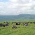
Arctic deserts, tundra, forest-tundra, forest zone, forest-steppe, steppe, semi-desert, subtropical zone.
4. Natural conditions of which zones are most favorable for human life?
The natural conditions of the subtropical zone are most favorable for human life and economic activity (not too hot and not too cold).
5. Natural resources of which zones are the most developed by man?
The natural resources of the steppe zone, together with the forest-steppe, are the most developed by humans.
Arctic deserts
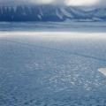
1. Where is the zone of the Arctic deserts of Russia located? Why is it called the ice zone?
The Arctic desert zone is located on the islands of the Arctic Ocean and in the far north of the Taimyr Peninsula. Due to the widespread occurrence of glaciers, the Arctic desert area is often referred to as the ice zone.
2. Find on the map and write down all the islands that make up the ice zone.
Northern Island of Novaya Zemlya, Franz Josef Land, Severnaya Zemlya (Komsomolets Island, Oktyabrskaya Revolyutsii Island, Bolshevik Island), Novosibirsk Islands (De Long Island, Anzhu Island, New Siberia Island, Kotelny Island ), partly about. Wrangel.
3. The ice zone is characterized by exceptional severity of nature. Large areas of it are occupied by glaciers, and in areas free from glaciers, there is snow cover almost all year round. Using the atlas maps, determine:
Climate zone name- Arctic belt
Average temperatures:
Winters -30⁰С
Summer + 3⁰С
4. And in such harsh conditions there is life! Which representatives of the fauna of the Arctic desert are shown in Figure 13? How are they adapted to live in harsh conditions?
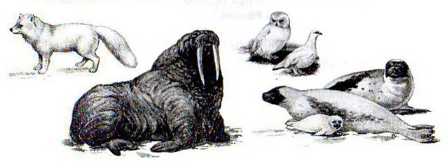
Arctic foxes, walruses, white owls, ivory gulls, seals.
All birds are fed by the sea. There are many algae in the sea. They feed on crustaceans, crustaceans - fish, and fish - birds.
Seals also feed on fish. These animals are excellent swimmers: they have an elongated, streamlined body, and their legs have turned into flippers. Seals have a thick layer of fat under their skin that protects them from the cold. Walruses are similar to seals, but much larger and have powerful tusks.
The warmth of the body of the Arctic fox in the cold is retained by its long coat and downy undercoat. By winter, the density of the fur increases.
5. Using various sources of geographic information (text of paragraph 33 of the textbook, atlas maps, drawings, paintings), make a "portrait" of the Arctic desert zone.
The arctic desert zone is the northernmost of the natural zones, which is characterized by an arctic climate. It has low air temperatures in winter (up to -60⁰C), on average -30⁰C in January and + 3⁰C in July. The spaces are covered with glaciers, rubble and rock debris. It is practically devoid of vegetation: there are no shrubs, lichens and mosses do not form a continuous cover.
The fauna is predominantly marine: walrus, seals, in the summer there are bird colonies.
Terrestrial fauna is poor: arctic fox, polar bear, lemming.
Tundra and forest-tundra
1. Name the most typical features of the tundra zone, explain the reasons for their formation.
Waterlogged soils, waterloggedness, strong winds, low vegetation.
Causes: climate (temperature, precipitation, wind), relief and geographic location.
2. On the contour map (Fig. 14) mark the border of the tundra and forest-tundra zones, the border of permafrost and the July isotherm + 10⁰С. Sign the names of large cities located in these zones.
Big cities: Murmansk, Naryan-Mar, Vorkuta, Norilsk, Salekhard.
3. What are the main types of nature management in the northern territories?
Marine fishing, reindeer husbandry, hunting, mining.
4. What environmental problems are to be solved in the tundra zone? What is the difficulty in solving them?
Poaching - It is impossible to combat illegal hunting in such a large area. Damaged by tracked vehicles, the soil layer of the tundra has been restored for more than a dozen years - other types of transport are not suitable for use in the Far North. Contamination of the surrounding area during oil production and due to fuel leaks from oil pipelines.
1. What conditions are necessary for the spread of the forest zone?
Severity of climate, degree of moisture, relief, number of sunny days, soil.
2. The forest zones of our country consist of:
Taiga, mixed and deciduous forests.
Explain the reasons for this variety. On the contour map (Fig. 14), use conventional symbols to show the main areas of distribution of forests of different types.
Such a variety of forests is associated with their location in different climatic zones.
3. Having studied Figure 15, draw conclusions about the possibilities for the development of the taiga zone by humans.
Forestry, river fishing, hunting for upland game (wood grouse), large animals (bear, elk, wild deer) and fur animals. There are certain opportunities in the taiga zone for agriculture as well. They are found primarily in the southern part of the zone with relatively fertile soddy-podzolic soils.
4. Give the characteristics of the climate, soil, flora and fauna of the forest zone.
The forest zone is characterized by the spread of forest vegetation mainly from coniferous and deciduous species and the predominance of podzolic and brown soil types of soil formation.
Average air temperatures of the coldest months: from -40 to 5⁰С, the warmest from 10 to 20⁰С. More moisture falls out almost everywhere than evaporates. Plains in vast areas are swampy.
Vegetation: coniferous, broad-leaved, mixed forests with developed moss and grass cover, undergrowth.
Fauna: wolves, lynxes, bears, moose, chipmunks, sables, hares, wood grouses.
Forest-steppe and steppe
1. On the contour map (Fig. 14) mark the boundaries of the steppe zone.
2. Explain the relationship between the components of nature in the steppe zone. Show the influence of climate and vegetation on the formation of the most fertile soils in our country - chernozems.
Chernozem occurs in steppe and forest-steppe zones. The main factor behind its appearance is favorable weather conditions. In the summer, high temperatures prevail in places of natural occurrence of chernozem. They improve the metabolism between soil and plants. The optimal amount of precipitation in combination with groundwater forms the required moisture level. Otherwise, nutrients are washed out from the soil, but in the case of chernozem, they are fixed in the upper layers, which gives a high level of soil fertility.
3. The Russian historian V.O. Klyuchevsky wrote: “A man, minute by minute and alternately, he adapts to the nature around him, to its forces and its methods of action, then he adapts them to himself, to his needs, which he cannot and does not want to give up ". According to V.O. Klyuchevsky, the special warehouse of the character of the Russian person had two sources - the forest and the steppe.
Think about what features of a person's character can be formed under the influence of the steppe, which - under the influence of the forest.
Influenced by the forest: isolation, a tendency to loneliness, going out on the road in roundabout ways, patience, enterprise.
Influenced by the steppe: breadth of soul, liberty, prowess, endurance, impetuosity, intolerance.
4. Make a description of the steppe zone according to the plan proposed in task 9 on page 180 of the textbook.
The steppe zone is located south of the forest zone. Average temperatures in winter months are from 0⁰C to -20⁰C, and in summer from + 20⁰C to + 28⁰C. The annual value of heat and power resources is more than 8000 MJ / m² per year. The growing season of plants is 160 days on average. Annual precipitation is 250-300 mm. K (humidification) = 0.4-0.5.
The relief is a plain with slight fluctuations in altitude. The annual flow is 10-15 mm. The main soils are chernozems, which have increased natural fertility, a high content of humus in the upper layers.
A characteristic feature of the steppe is the treelessness of huge plains covered with rich herbaceous vegetation.
Fauna: consumers of green and underground parts of plants predominate - voles, hamsters, ground squirrels, hares and predators feeding on them - corsac fox, weasel. Species of hibernating mammals and a small number of sedentary and hibernating birds are characteristic.
The natural resources of the steppe zone are favorable for growing cereals, especially spring wheat. The presence of meadows with thinned herbage makes it possible to engage in sheep breeding.
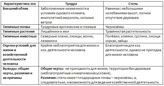
5. Compare the treeless zones of our country.
Semi-deserts, deserts and subtropics
1. On the maps of the atlas, determine which territories of Russia are located in the zone of semi-deserts and deserts.
The semi-deserts and deserts of Russia are located in the Caspian and Eastern Ciscaucasia (Astrakhan region, Republic of Kalmykia).
2. How are plants adapted to living conditions in the desert? Draw and list the most typical plant adaptations to this climate.
Long roots to "extract" groundwater from the depths. Leaves and stems with thorns or other devices to prevent moisture evaporation. Small size.
3. Semi-deserts - good pastures for sheep, camels, horses. What should be done to be able to engage in agriculture in this zone?
Irrigation of the soil is necessary.
4. The subtropical zone in Russia includes the small Black Sea coast of the Caucasus. Determine which famous resorts are located here using the atlas map.
Sochi, Tuapse, Anapa, Gelendzhik.
Altitudinal zonality
1. Why in the mountains the change of natural zones occurs from the bottom to the top?
Temperature and pressure decrease with height, the amount of precipitation increases to a certain height, lighting conditions change. Due to the change in climatic conditions, there is also a change in natural zones.
2. Based on the analysis of Figure 60 of the textbook, explain what determines the set of altitude zones in the mountains.
The number of altitudinal zones depends on the height of the mountains and their location.
3. Imagine that the height of the Southern Urals is 5000 m. What belts would then appear in these mountains? Sign them in Figure 16, show with conventional signs the types of vegetation characteristic of each of the belts.
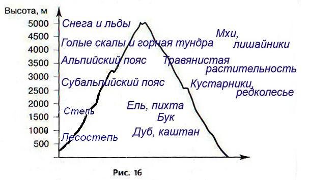
4. In which mountains of Russia is the altitudinal zonation most fully expressed? Explain why.
The Caucasus is the most striking example, because natural conditions vary from subtropics in the lowlands of Transcaucasia to eternal snow and ice in the Greater Caucasus. Also: Altai, Sayany, Kamchatka, Far East.
5. Find on the map and write down the cities of Russia located in the mountainous areas.
Yekaterinburg, Chelyabinsk, Gorno-Altaysk, Vladikavkaz, Nalchik, Karachaevsk, Grozny.
Specially protected natural areas (SPNA)
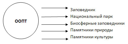
1. List the types of protected areas that exist in Russia.
2. Based on the analysis of the atlas maps and the textbook (Fig. 61), determine in which natural zones the largest number of protected areas in Russia is located.
The largest number of protected areas in Russia are located in nature reserves.
3. Under what conditions is it possible to preserve nature and ensure its sustainable development?
With rational nature management, transparency in the work of environmental organizations and their close connection with public associations and the population in solving environmental problems.
4. Using various sources of information (atlas maps, textbook materials, additional literature), make a description of one of the protected natural areas of Russia.
Astrakhan Nature Reserve is located in the Volga delta. It was founded in 1919 to protect the unique natural complex of the Volga delta, places of mass nesting of birds, mass spawning grounds for commercial fish and wintering pits.
Since 1975 it has been of international importance. Astrakhan Nature Reserve is a kingdom of birds, of which there are more than 260 species. The workers of the reserve carry out the prevention of diseases and treatment of animals and birds, study the conditions of natural reproduction and artificial breeding of fish.