Indus Length: 3 180 kilometers.
Indus Basin Area: 960,800 square kilometers.
Indus food method: in the upper reaches mainly from melting, in the middle and lower reaches - from melting snow and precipitation.
Tributaries of the Indus: Gartok, Zanskar, Dras, Shaisk, Shigar, Gilgit, Kabul, Panjnad.
Indus inhabitants: snakehead, yellow-cheeked, octopus minnows, white, silver carp ...
Freezing Indus: does not freeze.
Where the Indus flows: The Indus originates in Tibet at 32 ° north latitude and 81 ° 30` east longitude (from Greenwich), at an altitude of 6,500 meters, on the northern slope of Mount Garing-boche, near the northern tip of Lake Manassarovar, to the West of which are the sources of Setlej, and to the East - Brahmaputras. the current of the Indus goes to the North-West, after 252 km of current it takes the Gartok from the left, which flows down from the western slope of the Garing-boche, after which the Indus cuts through the plateau, and at the La-Kiel pass it invades the narrow valley that separates the Kuen Lun from the Himalayan mountains, flows through Ladak below its capital, the city of Leh, receives at an altitude of 3,753 meters the rapid Zanskar, then the Dras tributary and enters Baltistan, where the Shayok flows into it on the right, descending from the Karakorum mountains, and where I. receives the name Aba-Sind , that is, the father of the rivers. Slightly higher than Iskardo, or Skardo, the capital of Baltistan, I. takes the Shigar on the right, and then a number of other mountain tributaries. From Skardo the Indus flows for 135 kilometers to the North-North-West, at 74 ° 50 'East longitude turns to the South-West and then takes Gilgit on the right. A little lower, the Indus rushes into the gorge of the Himalayan mountains, 3,000 meters deep, where the "sources of the Indus" were previously believed, although the river is located in this place at a distance of more than 1,300 kilometers from its actual beginning.
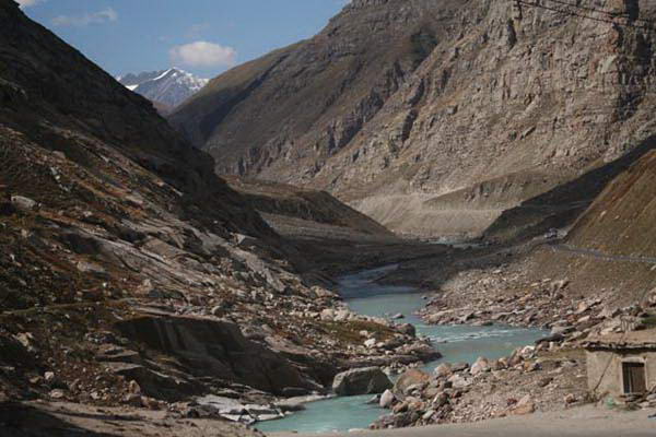
On leaving the mountains, the Indus spills at first in a wide channel among a vast plain, which was once a lake, and joins with the Kabul River, the most significant of its right tributaries; here the width of the Indus is 250 meters, while the depth is 20-25 meters in high water, and 10-12 meters in shallow water. A little lower, the Indus hits the rocks, from which the city protecting the crossing of the river received the name Attock (delay). From here, the river for 185 kilometers must again make its way in a long row of gorges between steep, stone walls, until finally, upon exiting the Karabakh or Garden gorge, the Indus finally leaves the region of the mountains and snakes in long meanders along, bordered by lateral streams or branches and false rivers indicating the former channels of the main river. Here the Indus, not receiving significant inflows, gradually decreases from evaporation to Mitkhan-kot, near which it again receives Panjnad, formed from the confluence of Jilam, Chinab, Rava and Setlej, the upper course of which, together with the Indus, forms the famous Five Rivers. At the confluence with the Indus, the Panjnad is 1,700 meters wide, while the width of the Indus itself, with an equal depth (4-5 meters), does not exceed 600 meters. Above Rory, in the Sindh region, where the Indus turns to the South, the Happa (Eastern Happa) arm separates from it, which flows along the South-East, but reaches the sea only during high water. Once the Happa appears to have served as the main channel of the Indus. Other hollows, wide and deep, testify to the incessant wandering of the river, looking for the most convenient way to the sea. A study of this area leads to the conclusion that the Indus was constantly moving further and further from East to West, either due to a swinging movement in that direction, or due to the rotation of the globe, forcing the rivers of the northern hemisphere to deviate to the right from the normal direction. This gradual movement of the Indus to the West leads to the fact that the neighboring areas lying to the East of it are more and more dried up, and many freshwater streams, separating from the main river, turn into. At Gaidarabad, 150 kilometers from the sea, the Indus Delta begins, forming a triangle of 8,000 square kilometers, the base of which stretches over an area of 250 kilometers along the coast. The number of mouths of the Indus cannot be determined with accuracy, since it changes with each flood. During this century, the main channel has changed location many times.