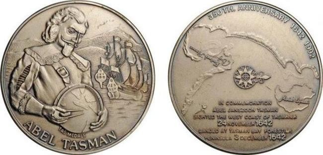
The year 1642 was marked for Holland by a number of discoveries, which were reflected on the maps of the world. At this time, the governor of the Indian possessions of the state is looking for someone who could establish the features of the location of Australia. At that time, there were assumptions about its belonging to the southern continent. It was also necessary to find a new path along which one could pass from Java to European countries. The person who managed to accomplish all this becomes Abel Tasman, an experienced traveler and scientist.
The small homeland of Abel Tasman was the suburb of Groningen, where he was born in 1603. He received his education at home, he acquired many knowledge and skills on his own. As an adult, he decided to connect his life with sea voyages. Having reached his thirtieth birthday, Abel already had considerable experience as a traveler - he visited Batavia and the neighboring islands.
He later appears in Java, where he meets with the local governor. He is preparing an expedition to the Pacific Ocean to explore the northern direction. Tasman was also chosen among the sailors sailing with Captain Kwast. The journey was not easy. Not finding the coveted islands that were indicated on old maps, the team was able to explore Japan and the Kuril Islands. On the way, the sailors faced the eternal misfortune of all who went to sea - scurvy. Most of the team died. Tasman himself has repeatedly shown himself to be a bold and decisive helmsman, repeatedly passing on a ship through storms and terrible storms.
Upon his return, Tasman's merits were assessed, he was appointed commander of the next expedition. Despite the failed attempts of researchers in past years, the Javanese governor believes that Seidlandt is a fertile land to explore. He directs sailors to its shores. They were given the task to fully explore this land, and most importantly - to establish whether it belongs to the southern continent.
When Tasman's ships successfully withstood the storms that happened along the way, and reached the Australian coast, the captain headed south than his predecessors. The ships quickly left the mainland. According to the observations of the sailors, there were a lot of floating algae along the road to the south, but Tasman believed that because of this, one should not assume that there was a large land nearby. This was the correct conclusion, since only Antarctica was the closest continent to them.
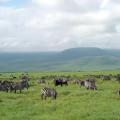
At the end of November 1642, the ships approached the high coastal cliffs. Later, these lands will be called Tasmania. Abel himself believed that this territory is adjacent to Seidlandt. During the landing on a new land, the team collected greens and fruits. Also, the sailors noticed marks on the bark of trees, which were clearly made by people who wanted to get to the bird's nests. Some of the crew members even said that they heard a melody that someone was playing in the forest, but the people of Tasman never saw the natives.
A few weeks later, the ships entered the waters separating the coast of Tasmania and New Zealand lands. It was decided to stop near the Cook Strait. There, the travelers met the Maori. Despite the peaceful beginning of the conversation, it ended in a skirmish and the death of several sailors.
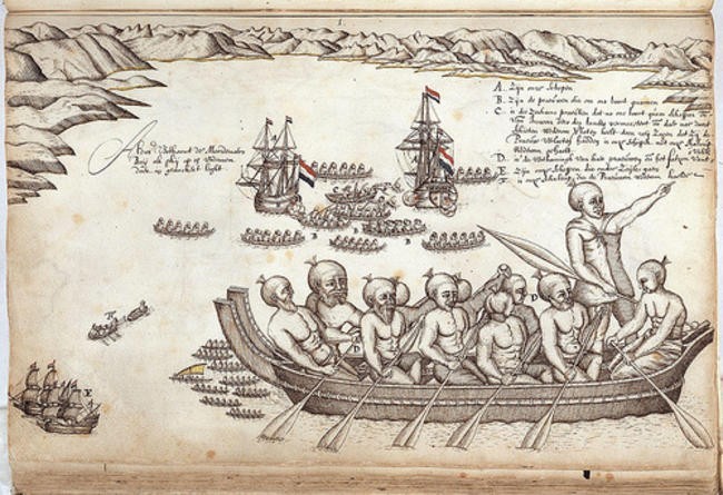 Maori canoes and Abel Tasman's ships in Assassin's Cove
 The meeting with the natives on the islands of Tonga was quite different. Here Tasman and his people received a warm welcome. It is worth noting that the discovery of these islands greatly influenced the power of Holland in the region. Before Tasman, only a group of small islands of minor importance were known in the area.
Subsequently, during the expedition, Tasman noticed the Fiji Islands, but it was not possible to examine the coast in detail. Prolonged foggy and rainy weather became the main obstacle. Tasman also saw New Guinea only from afar. The main disadvantage of the trip, according to historians, was its too large scale. Tasman had to travel a long way, but at the same time he did not have the opportunity to study new lands in detail. Despite this, he successfully passed the giant ring, inside which were Australia, New Guinea and Tasmania.
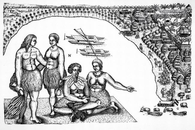 Gilseman woodcut from the travel diary of Abel Tasman (1642-1643) depicting the clothing, boats, and communities of the Tonga people.
 Returning to the shores of the Javanese colonies, Tasman again receives an assignment from the government. Now he has to determine if New Zealand is separated from the mainland. None of the predecessors was able to pass into the Gulf of Carpentaria, which, according to assumptions, could serve as a "dividing strip".
The new journey brings no less discovery than the old ones. Tasman surveys the Australian coast and makes accurate markings on the map. It was his data that became the first in history to show what the Australian coast looks like.
And yet, contemporaries were able to appreciate the merits of this man. During all his wanderings, Tasman did not discover areas that would bring income in the form of spices or precious metals. The routes that Tasman laid were not considered profitable, and therefore were soon closed to avoid invasion by competing countries. After the death of his fellow governor, the navigator practically retired, only occasionally going out to sea for short distances. Later he began to trade on the islands belonging to the Malay Archipelago.
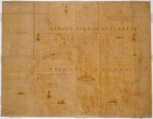 Abel Tasman's map, circa 1644.
 Abel Tasman made a breakthrough in the history of the study of our planet. He not only discovered new territories, but also indicated in detail the location of the islands in the region of Australia. It was thanks to him that it became finally clear that the Australian land is a separate continent, not in contact with New Zealand or New Guinea. Unfortunately, people do not always understand the merits of those who devote their destiny to discovering new things. Despite this, the geography of our time keeps the name of the traveler in the name of the land that he discovered - Tasmania.