By type of settlement settlements are subdivided as follows: (on maps
their names are highlighted in different fonts):
Urban-type settlements (workers, resort and other settlements);
etc., not officially classified as urban-type settlements;
Settlements of rural and dacha type (stanitsa, villages, villages, kishlaks, auls), as well as
separate courtyards.
On maps, their names are distinguished with different font designs (Fig. 7.5).
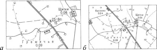
Rice. 7.5. Displaying the type of settlement on topographic maps:
Dreams- town; New
- settlement; Elbow
- village
rural type
By the number of inhabitants settlements are subdivided into the following gradations:
Cities with the number of inhabitants:
1,000,000 and more
from 500,000 to 1,000,000
from 100,000 to 500,000
from 50,000 to 100,000
from 10,000 to 50,000
from 2,000 to 10,000
less than 2,000
Urban-type settlements with the number of inhabitants:
2,000 and more
less than 2000
Settlements at industrial enterprises, railway stations, marinas
etc., not officially classified as urban-type settlements, with the number of inhabitants:
1,000 and more
from 100 to 1,000
less than 100
Settlements of rural and suburban type with the number of inhabitants:
1,000 and more
from 500 to 1,000
from 100 to 500
less than 100
separate courtyards
The number of inhabitants in settlements is established according to the main cartographic
materials using the latest administrative and territorial reference books
and lists. The data of the census of settlements are necessarily involved.
The number of inhabitants is displayed on maps in font height. On old maps under the name
the number of households is indicated by the number of settlements of the rural type, and the number of new
inhabitants in thousands with rounding (fig. 7.6):
with the number of inhabitants less than 1,000 - up to 0.01 thousand
from 1,000 to 100,000 - up to 0.1
more than 100,000 - up to thousands.
For example, if the number of inhabitants is 1 212 345, 17 145, 40, signatures are given accordingly
1212; 17,1; 0,04.
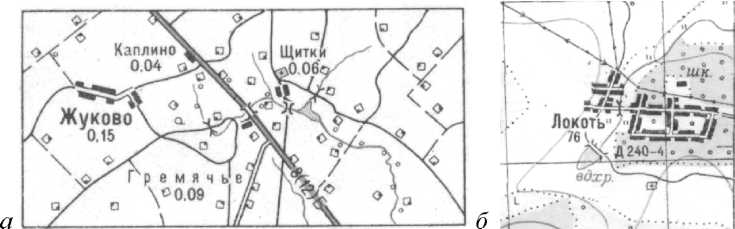
Rice. 7.6. Indication of the number of inhabitants in rural settlements:
a
- on new topographic maps in thousandths;
b
- on old maps indicating the number of yards
Political and administrative significance settlements displayed on maps
allocation of capitals of states, administrative centers and settlements in which
local authorities are located.
In addition, on these maps, underscore the name of the settlement, one
nominal names with the names of railway stations, wharves (Fig. 7.7).
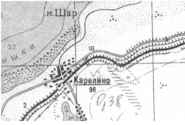
Rice. 7.7. Locality Karelino,
eponymous
with the name of the train station
The nature of the layout. When depicting settlements on topographic
maps must display their layout. Cities can have regular, irregular
ny and mixed layouts.
Typical for modern cities is regular
pla
ning: rectangular, radial and combined.
Varieties of these layouts for
cauldrons are shown in Fig. 7.8.
Re2
ular layout
- quarters have the form of regular geometric shapes
and relatively straight streets.
Nere2
ular layout
- quarters can have any shape and size, on
The presence of narrow and crooked streets.
Mixed layout- part of the city has a regular layout, and the other part -
irregular.
Straight2 floor layout - all streets in the city are mutually perpendicular.
Radial layout- all streets are directed towards the city center.
Combined layout- part of the city has a radial structure, while the other
part - rectangular.
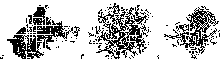
Rice. 7.8. Varieties of city layouts:
a- regular (rectangular); b- radial; v- combined
naya; 2 - irregular; d- mixed
The structure of rural settlements is:
Quarterly- represents the correct quarters, mutually separated
perpendicular streets. The built-up part of the quarters runs along the streets.
Private- represents buildings stretched out in one row with adjoining
on the one hand, household land.
Precinct- is a group of courtyards placed in disarray throughout
the area occupied by the settlement.
The nature of the location of rural-type settlements on the terrain depends on the geo
graphic landscape. They can be placed along river valleys, along ravines, along the banks
lakes and seas, at crossroads, etc. (Figure 7.9).
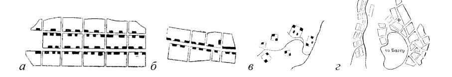
a -- quarterly; b- private; v- local placement;
2 - settlement in a mountain valley and near a lake
Rice. 7.9. Types of development in rural settlements:
d
- settlement along the ravine and watershed
Unsystematic building rural settlements are shown with conventional signs
individual buildings. With a large number of buildings, their selection is made, while
first of all, industrial enterprises, public buildings (school
ly, hospitals) and the largest buildings. By generalizing such a populated
point, it is necessary to preserve all extreme buildings, regardless of their size, so that you
divide the area occupied by this settlement (Fig. 7.10).
Rice. 7.10. An example of an image of a rural-type settlement with unsystematic buildings:
a b
v
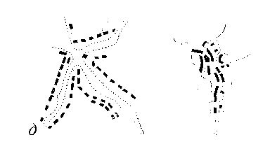
Dispersed development villages of rural type are shown by conventional signs
kami of separate yards. The selection of yards is carried out in the same way as in a haphazard development.
The outer courtyards are also saved to highlight the total area occupied by the data.
settlement (Fig. 7.11).
a- on a map with a scale of 1: 25,000; b- on a map with a scale of 1: 50,000
Rice. 7.11. An example of an image of a rural-type settlement with dispersed buildings:
v
- on a map with a scale of 1: 100,000
The dispersed type of settlement is characterized by the fact that individual residential buildings
ki are located at a considerable distance from each other (more than 50 m). This type is characteristic
for Abkhazia, Central Asia.
As a rule, all settlements should be shown on topographic maps.
you. When creating maps of scales 1: 50,000 and 1: 100,000 for densely populated areas with pain
With the number of individual yards, some of the yards may not be shown. On the cards, created
located in uninhabited and sparsely populated areas, all buildings are shown, including those not
residential.
On maps with scales 1: 25,000 and 1: 50,000, fire resistant
buildings (stone
nye, brick, reinforced concrete) with orange fill, non-fire resistant
(wooden,
adobe, etc.) - filled with yellow. On maps of scale 1: 100,000 the nature of the fire
the resistance of buildings is not shown (Fig. 7.12).
Rice. 7.12. An example of an image of a rural-type settlement:
a- on a map with a scale of 1: 25,000; b
- on a map with a scale of 1: 50,000;
v
- on a map with a scale of 1: 100,000
In large cities with more than 50,000 inhabitants, oran is distinguished by the background color
chew-colored neighborhoods with dense buildings. Densely built up neighborhoods include
quarters or their parts, in which the distance between buildings, as a rule, is no more than 50 m.
In other cities with less than 50,000 inhabitants, quarters are shown with black fill
colors (fig. 7.13).
Rice. 7.13. An example of images of cities on maps at a scale of 1: 100,000:
a- a large city with more than 50,000 inhabitants; b
- small town
with a population of less than 50,000 people
The compilation of settlements is carried out in a certain sequence
(fig. 7.14):
1. First, objects are applied that are economically important or of importance
landmarks (industrial enterprises, tower-type structures, churches, memorials
nicknames).
2. An image of the outer contour, trunk and main streets is given.
3. Image of secondary streets and driveways.
4. Intra-block buildings - buildings and structures in blocks are shown.
5. Filling the land contours with conventional symbols.
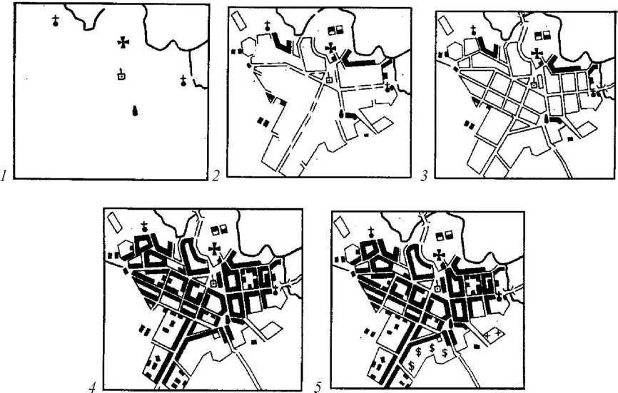
Rice. 7.14. The procedure for compiling a settlement
When compiling settlements of all three scales, it is necessary to accurately preserve
definition of the outlines and position of streets, lanes, driveways, squares and quarters.
The concept of "street" includes the carriageway and sidewalks, green spaces between
them and improvement elements (lanterns, direction signs, fences, etc.).
On a map with a scale of 1: 25,000, all streets, thoroughfares and dead ends are shown. On the map ma
headquarters 1:50 000 some minor streets are not shown if their display interferes
correct display of buildings. On a map with a scale of 1: 100,000, the selection of streets and dead ends
produced depending on the size of the quarters of settlements.
Minor streets and dead ends are eliminated by combining small neighborhoods
into larger ones. At the same time, it is necessary to preserve the layout, shape and size of the quarters.
On a map with a scale of 1: 25,000 when depicting city quarters and urban settlements
type, all buildings and structures in them are shown, if the distances between them are not
less than 0.3 mm. If the distance is less than the specified value, then the structure follows until
call with selection. Outstanding buildings are applied first, then buildings,
large in size, as well as located at crossroads and on the outskirts of
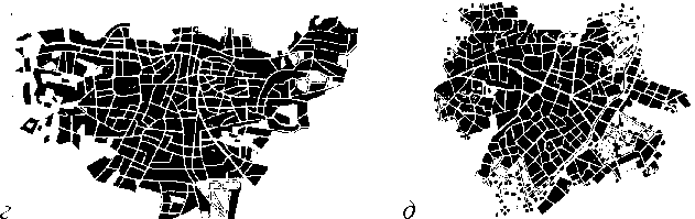
settlements. Examples of generalization of the image of building blocks in cities
and villages of the dacha and rural type are shown in Fig. 7.15, 7.16.
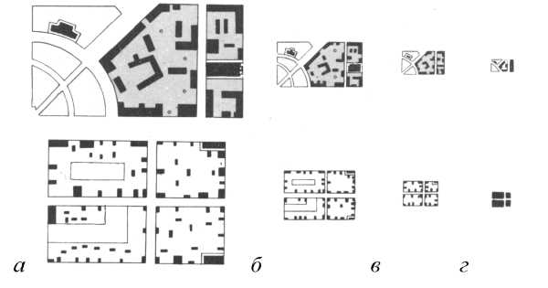
Rice. 7.15. Generalization of the image of buildings in small towns and urban settlements
type in scale:
a - 1:10 000; b - 1:25 000; v- 1:50 000; g - 1: 100,000

Rice. 7.16. Generalization of the image of buildings in dacha and rural settlements
in scale:
a - 1:10 000; b - 1:25 000; v- 1:50 000; g - 1: 100,000
These maps also highlight parks, squares, fruit, berry and citrus orchards,
vineyards, sports grounds, as well as wastelands in the quarters of settlements.
Inscriptions of the names of settlements. All inflicted settlements must
their official name should be indicated. On a map with a scale of 1: 100,000, you can leave without
signatures of names of settlements with a population of less than 50 people, if their signatures
on this site it is impossible to place due to the large overload of the card.
1. What are the requirements for the image of settlements on a large
large-scale topographic maps?
2. How settlements are classified when they are depicted on a large scale
headquarters topographic maps?
3. How is the type of settlement transmitted on large-scale topographic
cards?
4. How are cities, urban-type settlements and rural-type settlements subdivided according to
the number of inhabitants?
5. How is the number of inhabitants represented on maps at a scale of 1: 25,000, 1: 50,000, 1: 100,000?
6. What is the difference between showing the number of inhabitants in rural-type settlements on old maps
and new ones?
7. What names of settlements are underlined in the name?
8. What layouts can cities have?
9. What is the difference between regular city planning and irregular planning?
10. What is the difference between mixed and combined city planning?
11. What types of buildings are there in rural-type settlements?
12. Give a description of the haphazard development of a rural-type settlement.
13. Give a description of the dispersed development of a rural settlement
14. How are settlements selected on maps of these scales?
15. In what sequence is the settlement compiled on the maps of these mas
headquarters?
16. How are streets, thoroughfares and dead ends selected?
17. How are outstanding buildings displayed?
18. To what scale, inclusive, is the fire resistance of the neighborhoods shown? How is she
transmitted on cards?
19. What does the orange color of quarters mean on topographic scale maps?
20. How is the selection of buildings done within the quarters of settlements?
21. How are densely built-up parts of the blocks shown?
22. How is the selection of buildings done in case of haphazard construction?
23. How is the selection of detached yards done when depicting settlements
tov with dispersed buildings?
24. What settlements on maps with a scale of 1: 100,000 can be left without
write?
7.4. Image of communication lines and their generalization
On topographic maps, roads are subdivided by mode of travel, mate
rial of coverage, conditions of traffic and throughput.
Topographic maps show:
Railways;
Monorails and cableways, funiculars and bremsbergs, tram lines
and ground sections of metro lines;
Highways, roads with improved surfaces and roads from to
covering;
Unpaved roads or improved unpaved roads, unpaved roads, field roads
and forest roads;
Caravan routes, pack and hiking trails, winter roads;
Railway structures (stations and metro stations, crossings, boards
forms, stopping points, railway stations, depots, checkpoints, semaphores and light
tophores, etc.);
Bridges, tunnels, flyovers, viaducts, embankments and cuttings;
Pipes, pedestrian bridges, paved road ramps, fascia road sections,
gati, rowing;
Mountain passes, fences and casing along the roads.
The following requirements are imposed on maps of all three scales:
1. Correctly convey the density of the road network.
2. Accurately convey the location of the roads.
3. Correctly show the class of each road and its condition.
4. Clearly show intersections of roads, road sections near bridges, crossings and in places where
difficult to detour.
5. To display in detail the road structures that characterize the equipment of the roads,
serving as landmarks.
6. The axis of the conventional road sign must exactly correspond to the axis of its image on
cartographic material.
7. The image of roads should be consistent with the image of other elements from
holding the card.
Land routes according to the mode of movement, they are subdivided into rail
and trackless
... Railways include railways, cableways, funiki
leers and bremsbergs, tram lines and ground sections of metro lines.
Railways shown on maps with subdivision by track width (wide
co-gauge with a track gauge of 1435 mm and more, in the Russian Federation - 1524 mm) and narrow-gauge with a gauge
track less than 1435 mm); by the number of tracks for one-, two- and multi-track; by type of traction - elek
triified and others, and according to the condition of the canvas - active, under construction, dismantled
ny (Figure 7.17).
Rice. 7.17. Depiction of railways and structures on large-scale topographic
maps:
a- single-track, double-track, three-track; b- electrified: single track, double track
nye, three-track; v- narrow gauge railways and tram lines; d - suspended up to
horns and funiculars; d - railway stations
In addition, monorail railways, tram lines are also shown.
(a general conventional sign with narrow-gauge railways), suspension roads, funi
coolers (railways on steep climbs, in the mountains with cable cars) and Bremsbergs, on
land plots of metro lines.
If a railway line passes through a settlement, then it is shown without
break, and if necessary, you can reduce the thickness of the sign.
All railway stations, sidings, platforms and stops are shown on the maps.
new items. If the stations are located outside settlements, then it necessarily gives
their name. On a map with a scale of 1: 25,000, semaphores and traffic lights are shown.
Roads when depicted on maps are subdivided into highways, motorways
ghee with improved surface and paved roads, on improved unpaved
roads, dirt (country) roads, field and forest roads, caravan routes
and pack trails, hiking trails (see subsection 5.3). With special conventional signs,
There are wooden roads and winter roads (Fig. 7.18).
![]()
Rice. 7.18. An example of road classification on large-scale topographic maps:
a- motorways; b- roads with improved coverage; v- roads with
coating; d - improved dirt roads; e - roads with wooden surfaces;
e- dirt roads and difficult-to-pass road sections; f- field and forest roads;
s- winter roads
Highways, roads with improved surfaces and roads from to
all are shown on the maps of scales, regardless of the density of the road
networks. Improved dirt roads are shown as well, as a rule, all, only with a
When using maps on a scale of 1: 100,000, small roads may be excluded.
Dirt (country) roads on maps at a scale of 1: 25,000 are applied, as a rule,
all. On maps of scales 1: 50,000 and 1: 100,000, roads are plotted with selection, if in this
the area has a dense network of roads. When drawing roads of lower classes, preference is given to:
1. Roads providing communication of settlements with railway stations
tions, marinas, airfields and high-class roads.
2. Roads that are a continuation of the main thoroughfares in settlements.
3. All roads that lead to water sources, through the passes to the state
borders or along borders.
4. Connecting settlements along the shortest distance.
5. Roads with the best driving conditions and a smoother
profile.
When compiling roads, the features of the mapped terrain must be taken into account.
ritories. For example, winter roads are only shown on low-volume maps.
inhabited and hard-to-reach areas, where there are no higher class roads and travel
possible only in winter.
On maps created for sparsely populated, mountainous and desert areas with a sparse network
roads, all caravan routes and pack paths are shown.
Hiking trails are shown when depicting hard-to-reach areas (mountains,
forests, bushes, swamps), where there are no other means of communication.
Generalization of the road contour is practically not done. Generalization is allowed when iso
wandering winding roads in the mountains, when all the convolutions cannot be conveyed, while it is necessary
dimo keep all major road curves.
In addition to the main roads, the maps are marked with fascinating
road sections, gati
and rowing
with a length of at least 2 mm.
Fascines- are bunches of brushwood, laid on longitudinal beds
and pressed by the poles; from above the fascines are covered with earth or sand.
Gati - solid flooring of logs, placed over brushwood or poles.
Rowing- low embankments of soil, stones, and sand.
Sometimes all these primitive structures along the roads have local names, for example
measures, pavement.
If the roads cross mountain ranges, then it is necessary to show the passes with the signature
with their elevation marks and the period of availability, for example: (GU-X), i.e. the pass is accessible
from April to October. The main passes should be distinguished by the larger size of the sign.
and signatures.
When depicting highways and highways, their technical character is signed
statistics: coverage width (for highways - the width of one lane and the number of
los), the width of the road with shoulders (for highways) and the material of the pavement, and also denotes
the boundary of the change of the coating material. The coating material is denoted by conventional abbreviations.
signed signatures:
A - asphalt concrete, asphalt
B - cobblestone
B m - bitumen-mineral mixture
B r - paving stones
G - gravel
K - chipped stone
C - cement concrete
Щ - crushed stone
Sh l - slag
When displaying improved dirt roads, only the width of the passage is signed
part of the road.
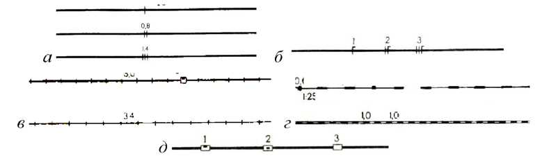
Images of highways and highways are given signatures of road numbers, as well as
allocate numbers of trans-main routes (European, Asian, etc.). Rooms
determined by the latest road maps and atlases of highways (Fig. 7.19).
At exits outside the frame of the sheet of the map of conventional road signs, their direction is signed
nie: the signature of the proper name of the nearest settlement is given and is indicated
distance in kilometers (fig. 7.19)
The procedure and rules for drawing up roads. Roads on scale data maps are always
are compiled in sequence from the highest class to the lowest. Railways and highways
are worked out at once on the entire sheet, and the rest are compiled in separate sections.
First, road structures are drawn up, the conventional signs of which interrupt
image of a road (for example, railway stations, tunnels, bridges). Then the composition
The road itself is laid, and only after that all other road structures are applied.
When depicting roads, it is necessary to ensure that the axis of the conventional road sign
exactly corresponded to the axis of its image on the cartographic material. Vectorization
roads are made strictly along the axis of the conventional road sign.
Violation of this rule is only allowed if the merger has occurred
roads with other objects. If, when constructing roads on a smaller scale,
if the road merges with the bank of a river, lake or sea, then the conventional sign of the road is shifted.
If there is a merger of two roads, then the conventional sign of the lower class road is displaced.
Rice. 7.19. Indication of road numbers and their directions on topographic maps
Turns and intersections of roads are worked out with special care on the map. Iso
The representation of roads must be consistent with the depiction of other content elements
maps (hydrography, settlements, etc.).
Questions and tasks for self-control
1. What types of roads are shown on large-scale topographic maps?
2. How are railways classified?
3. What are the requirements for the image of roads?
4. How is a railway line shown through a built-up area?
5. How are train stations displayed? What stations are subscribed to?
6. How are highways and dirt roads classified?
7. How is the selection of unpaved and field roads done on maps at a scale of 1: 100,000?
8. Taking into account what the configuration of the roads is transferred?
9. What are the characteristics of highways and highways?
10. How are the signatures of the numbers and characteristics of the roads given?
11. What road structures are shown on maps of these scales?
12. Which lower class roads are preferred for generalization?
13. When are winter roads shown?
14. What are fascines, gati, rowing?
15. What is the characteristic of roads crossing mountain ranges?
16. What signs at the exits of the main road map sheet?
17. In what order are the roads drawn?
18. In what case can the axis of the road be moved relative to its position by
original cartographic material?
7.5. Relief image and its generalization
on large-scale topographic maps
The relief on maps of all three scales is depicted contours, conventional signs
mi
cliffs, rocks, ravines, gullies, talus, etc. and elevation marks.
Image relay
epha is supplemented with signatures of absolute and relative heights of characteristic points locally
sti, labels of contour lines and indicators of the direction of the slopes (bergstrikami)
(see subsection 5.4, 5.4.1).
As a result of the fact that large-scale topographic maps are used to
detailed study and assessment of the terrain and various calculations and measurements on
them, then the most stringent requirements are imposed on the relief image:
1. It is necessary to visually convey the nature of the relief and the degree of its dissection.
2. Accurately display the location, size and shape of uneven terrain, character
its permeability, camouflage and protective properties, as well as the ability to orient
orientation on the ground.
3. Visually and correctly convey the morphological features of various types
relief (plain-erosional, hilly-moraine, mountainous, karst, volcanic,
relief of sands, etc.).
4. Accurately and clearly convey the main orographic lines and points (watersheds,
thalweg, ledges, peaks, saddles, etc.).
5. Correctly and clearly display the direction of slopes, their steepness, as well as sharp
surface disturbances (cliffs, ravines and gullies, bedrock outcrops, etc.).
6. Place the elevation marks in such a way that it is possible to quickly determine
division of the absolute heights of points of the terrain and the excess of some points over others.
When depicting the relief with horizontals, it is very important to choose the right height.
relief sections. The main section height is set depending on the nature
relief of the mapped territory. Within one sheet of the map, the main height is
cheniya does not change.
On topographic maps, according to the following you apply
section honeycomb (Table 7.4).