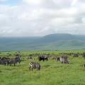
The central belt of the planet got its name equatorial due to its location on both sides of the equator from 5-8 degrees north to 4-11 degrees south latitude.
Eternal summer
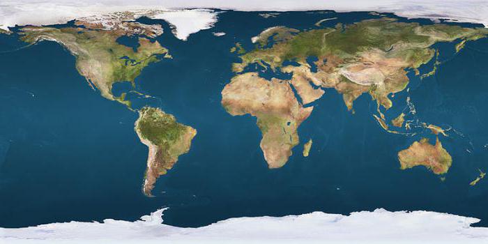
Bounded subequatorial consists of three areas:
- Continent South America: Amazon lowland;
- Mainland Africa: equatorial part; Gulf of Guinea;
- Part and the water area closest to them.
Equatorial latitudes simultaneously cover areas of both parts of the world, with the same climatic conditions in both the Northern and Southern hemispheres.
Formation of equatorial air masses
The amount of heat that the sun gives off to the earth's surface is one of the main factors affecting the climate of any corner of the earth. The degree of heating of the planet's surface depends on the angle at which the sun's rays fall on it. The closer to the equator, the more the Earth's surface warms up, therefore, the temperature of the ground air increases.
On the territory of the equatorial belt, the angle of incidence of the Sun's rays is the highest, therefore the average annual air temperature in the regions of the equatorial belt is +26 degrees with minor differences. the equatorial belt, heating up, rise and create an upward movement
A zone of low atmospheric pressure is formed near the Earth's surface - an equatorial depression. The heated and humid air that rises up becomes saturated and cools there. Thermal conversion collects many cumulus clouds that precipitate as rain.
The air masses of the equatorial belt forming in the depression zone always have a high temperature. The humidity in this area is also increased.
This is what makes the equatorial climatic zone unique. The characteristics of the air masses are always the same. Since they form in a zone of low atmospheric pressure over land and ocean, scientists do not subdivide them into marine and continental climate subtypes.
Features of air masses
The dominant air masses of the equatorial belt form the equatorial belt, which is characterized by:
- A high constant air temperature from 24 0 С to 28 0 С with slight differences during the year with a difference of 2-3 0 С. The change of seasons is imperceptible, summer reigns throughout the year. The average temperature in the equatorial zone does not change throughout the year.
- An abundance of atmospheric precipitation with two maximum precipitation corresponding to the zenith position of the Sun and two minima at the time of the solstices. It rains, but unevenly.
- The mode of precipitation in the equatorial belt and their amount falling per year differ for different regions of the equatorial belt.
The typical equatorial climate is characteristic of the Western Amazon and the Congo Basin. In the Congo Basin, the amount of atmospheric precipitation that fell per year is 1200-1500 mm, in some places 2000 mm per year. The area is much larger than the Congo Basin, the air masses of the equatorial belt are formed more intensively. The annual amount of precipitation reaches 2000-3000 mm. This is many times higher than the annual rate.
Equatorial climatic zone: climate characteristics
For the western part of the Andes and the north of the Guinean coast, the most abundant precipitation is characteristic, their amount can exceed 5000 mm per year, in some places up to 10,000 mm per year. Such an abundance of precipitation is influenced by a strong countercurrent between the trade winds of the north and south. In these areas, the summer maximum precipitation is expressed.
The precipitation regime in the equatorial zone differs significantly from season to season. The dry period is either absent or lasts one to two months. The large difference in summer and winter rainfall in these regions is due to the dry and dusty West African trade winds Harmatan. From late November to early March, it blows from the Sahara towards the Gulf of Guinea.

Equatorial belt: winds that shape the climate
The abundance of atmospheric precipitation is directly related to the intertropical convergence zone of the trade winds, the zone where the convergence of air currents is observed. The convergence zone stretches along the equator, coincides with the zone of low atmospheric pressure and is located most of the year north of the equator. In seasons, the ongoing displacements of the convergence zone are accompanied by changes most noticeable in the Indian Ocean basin.
Here the trade winds are replaced by monsoons. Stable winds change their direction depending on the season. The strength of the wind can change: from weak to heavy. Most of all tropical cyclones are formed in this zone. Tropical latitudes are characterized by high atmospheric pressure.

Trade winds and monsoons
Air currents are formed in them, which rush to the low pressure zone - to the equator. Due to the rotation of the Earth, the northeast trade wind near the equator takes a northerly direction, and the southeast trade wind takes a south direction. When they meet, they form a calm - a windless strip. Trade winds are weak air currents that blow along the equator all year round and are the most stable winds on the planet.
Thus, after the days of the equinox, the maximum precipitation falls in the equatorial zone. A slight decrease in precipitation is observed after the days of the solstices. A cloud accumulation forms above the earth's surface, warmed by the sun's rays. Usually in the afternoon there are heavy rains accompanied by thunderstorms. Over the sea, showers and thunderstorms occur at night, this is the difference between the sea and continental climate.

There is so much atmospheric precipitation that moisture does not have time to evaporate. The relative humidity is kept at 80-95%. Excess moisture swamps the soil, contributing to the growth of impenetrable multi-tiered equatorial forests. Above humid latitudes, the western monsoons constantly blow in the summer, and in the winter - the eastern, in Africa the Guinean monsoon and the monsoons of Indonesia.