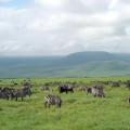
Climate-forming factors are the conditions for the formation of a certain type of climate. These are the reasons that affect air temperature, precipitation and other important indicators. Consider the main climate-forming factors in Russia - the largest country in the world in terms of area.
Solar radiation, latitude and other climate-forming factors
The star of our system is the main source of heat on Earth. Solar radiation and radiation levels are one of the most important reasons for the formation of the climate. Due to the sphericity of the planet, the angle of inclination of the rays is not the same at the equator, in the tropics and polar latitudes. But not only this condition determines what the air temperatures and seasons will be in a particular area. There are other main climate-forming factors:
- circulation of air masses;
- latitude of the area;
- relief features;
- the influence of the seas, oceans, the proximity of other continents.
Solar radiation
Not all rays of our star reach the surface of the Earth, while the amount of incoming energy is determined by the location of the territory and depends on a number of other reasons. Part of the radiation (about 20%) is reflected by the upper atmosphere. About 30% is scattered by clouds, dust particles and water droplets. The sum is made up of scattered and direct radiation reaching the hard shell of the planet. In this latter form, absorbed and reflected radiation is emitted.
The absorption depends on the specific heat and thermal conductivity of the underlying surface. Water has a high specific heat capacity, oceans and seas absorb 95% of direct radiation, gradually accumulate heat in summer, and slowly release it in winter. White snow, glaciers absorb about 15% and reflect 85% of the radiation that reaches the surface. For chernozem, the reflection index is 4%.
Climate-forming factors are interrelated causes of climate formation. Let us give examples of the influence of other conditions on the radiation balance. So, when moving from north to south, the total solar radiation decreases by about 2.7 times. On Sakhalin Island in eastern Russia, clouds reflect 70% of the sunlight. As a result, a more severe climate is formed than at the same latitudes within the continent.
Atmospheric circulation
The main reasons for the formation and movement of huge air accumulations are uneven heating of the earth's surface by the Sun. This is one of the main conditions for creating different atmospheric pressure on the planet. The characteristics of air masses depend on the place of their formation, for example, sea air dominates over the oceans, it is moist, over the mainland - dry continental. The abbreviated letter designations for these two varieties are, respectively, M and K. When the climatic factors of Russia are studied, they necessarily characterize the three main types of air masses - arctic, temperate and tropical. They can be marine and continental. The following abbreviations are used: MAV, KAV, MUV, KUV, MTV, KTV.
The types of dominant air masses determine the most important features of climate and weather:
- Atmosphere pressure;
- temperature in the surface layer of the atmosphere;
- direction of constant winds;
- air transparency;
- humidity.
Air masses are able to transform, change their physical properties, moving above the Earth's surface from one region to another.

Geographic latitude
The ratio between the input and expenditure of solar radiation - the radiation balance - is one of the main climate-forming factors. It affects the thermal regime of the soil and other surfaces, the lower layers of the atmosphere. The evaporation of water, the transformation of large air masses, and the life of humans and plants depend on the radiation balance. But which climate-forming factor is the main one? This latitude is the distance from the equator to the area of interest on the Earth's surface.
In July, the angle between the rays and the earth's surface in the illumination belt is almost 90 °. Then, per unit area there is more energy, the land heats up more, and from it the air. The farther from the equator and the tropics, the colder it gets.

The influence of geographical latitude on the climate of Russia
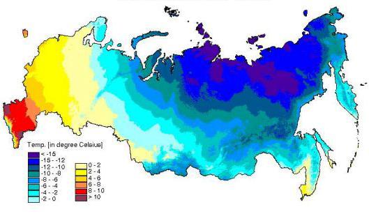
Let's consider how the main climate-forming factor influences on the example of the Russian Federation. The country stretches from the icy Arctic to the subtropics of the Caucasus, from the Baltic coast to Chukotka and the seas of the Pacific Ocean. The climate varies significantly from north to south and from west to east. Temperate air prevails, cold air masses from the Arctic often invade, the Siberian anticyclone and humid Atlantic air influence.
There is a great variety, but for Russia the main climate-forming factor is the distance from the equator. When moving to the southern borders of the country, the amount of solar radiation increases. The closer to the Arctic Circle and the North Pole, the colder it is. Thus, the long-term weather regime in different regions of the country mainly depends on the geographical latitude.

Relief, influence of continents and oceans - climate-forming factors
The distribution of air temperatures does not always strictly obey the law of latitudinal zoning and depends only on solar radiation. If we connect the cities of Russia with the same summer temperatures with lines, then it is easy to see that the isotherms of July are located mainly in accordance with the geographical latitude. But in January isotherms 0, -8, -10 ° С lie farther north than in Siberia. The climate of the territory up to the Urals is softened by the influence of the Atlantic Ocean and its warm currents.
The meridian chain of the Ural Mountains traps moist and warm air coming from the Atlantic. On the Pacific coast, the July isotherms are lower than at the same latitudes inland, due to the influence of the summer monsoon and the prevalence of scattered radiation on Sakhalin Island. When climbing mountains, the temperature drops even at the same latitude.

Asian maximum (Siberian anticyclone)
An area of high atmospheric pressure dominates over the territory of Mongolia from November to March. Air masses with low temperatures are formed from KAV coming from the north. At this time of the year, the climate of the region is almost unaffected by the Pacific Ocean. The mountains of southern and eastern Siberia prevent the spread of cooled air. The result is the lowest temperature in Russia and in the entire Northern Hemisphere in the surface layer of the atmosphere (from -40 to -70 ° C).
Observed when cold air stagnates in the basins. Then at an altitude of about 2 km it is warmer by about + 10 ... + 20 ° С than in depressions and at the surface of the earth. Having found out what factors are climate-forming, we were convinced that not only the reasons themselves are important, but also the combination of conditions in a certain territory.

Climate formation
More precipitation falls in the center and north of the European part of Russia than at the same latitude in Eastern Siberia. MSW comes to the west of the country from the Atlantic; cyclonic activity prevails here (low air temperatures, sleet, showers). There is little precipitation beyond the Arctic Circle, and the influence of KAV, poor in moisture, is felt. In Siberia and the Urals, the continental climate differs from the European regions of the country. Summers are relatively warm and short here, winters are long and very cold.
In the south, in the Astrakhan region, such climate-forming factors have a significant impact: geographical latitude and the associated value of solar radiation, atmospheric circulation. One can note the influence on the climate and weather in summer of dry and hot KTV, which comes from Kazakhstan, Central Asia. The flow of the same air masses to the Black Sea coast of Russia is delayed by high mountain ranges.

The specific conditions of Kamchatka were formed under the conditions of a combination of marine and sharply continental types of climate. The region is characterized by frequent weather changes, strong winds, a significant amount of precipitation, in the winter - in the form of heavy snowfalls.
Climatic weapon
Finding out what climate-forming factors are, we focused on natural processes and phenomena. It is necessary to explain such facts as the increase in average annual air temperatures and uneven precipitation in recent decades. Is this a natural law or a result of anthropogenic climate change?

It is difficult to give an unequivocal answer to this question. Disputes about whether climate weapons are being used, whether they have been created, or are just being developed, do not subside. The issue was especially actively discussed during the extreme heat in Russia in the summer of 2010. Temperatures in the central part of the country were 10 ° C higher than the average for the region. The year was the hottest since the end of the 19th century. There were massive forest fires, there was a surge in mortality among the population.

Climate weapons are ways of controlling the weather for military purposes. The enemy is damaged as a result of natural anomalies (droughts, floods). Scientists from the USA and the USSR began to work on the creation of climate weapons in the middle of the last century. Such actions contradict the UN Convention prohibiting the military use of means of influencing the natural environment. The US government denies artificial influence on the atmosphere with the aim of causing damage to other states, people and the environment.