Climatic zones are continuous or discontinuous areas that are parallel to the latitudes of the planet. Between themselves, they differ in the circulation of air currents and the amount of solar energy. The terrain, proximity to or are also important climate-forming factors.
According to the classification of the Soviet climatologist B.P. Alisov, there are seven main types of Earth's climate: equatorial, two tropical, two temperate and two polar (one each in the hemispheres). In addition, Alisov identified six intermediate belts, three in each hemisphere: two subequatorial, two subtropical, as well as subarctic and subantarctic.
Arctic and Antarctic climate zone
Arctic and Antarctic climate zone on the world map
The polar region adjacent to the North Pole is called the Arctic. It includes the territory of the Arctic Ocean, margins and Eurasia. The belt is represented by icy and, which are characterized by long severe winters. The maximum summer temperature is +5°C. Arctic ice affects the climate of the Earth as a whole, preventing it from overheating.
The Antarctic belt is located in the very south of the planet. Nearby islands are also under his influence. The cold pole is located on the mainland, so winter temperatures average -60°C. Summer figures do not rise above -20°C. The territory is located in the Arctic desert zone. The mainland is almost completely covered with ice. Land areas are found only in the coastal zone.
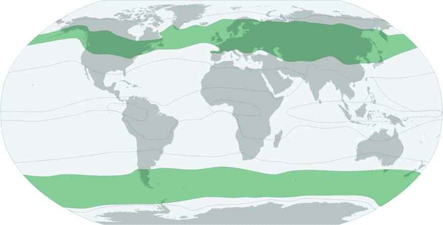
Subarctic and Subantarctic climate zone
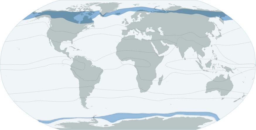
Subarctic and Subantarctic climate zone on the world map
The subarctic zone includes Northern Canada, the south of Greenland, Alaska, the north of Scandinavia, the northern regions of Siberia and the Far East. The average winter temperature is -30°C. With the advent of a short summer, the mark rises to +20°C. In the north of this climatic zone dominates, which is characterized by high humidity, swampiness and frequent winds. The south is located in the forest-tundra zone. The soil has time to warm up during the summer, so bushes and woodlands grow here.
Within the subantarctic belt are the islands of the Southern Ocean near Antarctica. The zone is subject to the seasonal influence of air masses. In winter, arctic air dominates here, and in summer masses come from the temperate zone. The average temperature in winter is -15°C. Storms, fogs and snowfalls often occur on the islands. In the cold season, the entire water area is occupied by ice, but with the onset of summer, they melt. Warm months average -2°C. The climate can hardly be called favorable. The flora is represented by algae, lichens, mosses and herbs.
temperate climate zone
Temperate climate zone on the world map
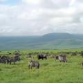
In the temperate zone lies a quarter of the entire surface of the planet: North America, and. Its main feature is a clear expression of the seasons of the year. The prevailing air masses give high humidity and low pressure. The average winter temperature is 0°C. In summer, the mark rises above fifteen degrees. Cyclones prevailing in the northern part of the zone provoke snow and rain. Most of the precipitation falls as summer rain.
Territories deep into the continents are prone to droughts. represented by an alternation of forests and arid regions. It grows in the north, the flora of which is adapted to low temperatures and high humidity. Gradually it is replaced by a zone of mixed broad-leaved forests. The strip of steppes in the south encircles all the continents. The zone of semi-deserts and deserts covers the western part of North America and Asia.
Temperate climates are subdivided into the following subtypes:
- nautical;
- temperate continental;
- sharply continental;
- monsoon.
Subtropical climate zone
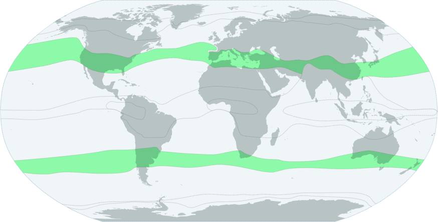
Subtropical climate zone on the world map
In the subtropical zone there is a part of the Black Sea coast, the southwest and, the south of the North and. In winter, the territories are influenced by air moving from the temperate zone. The thermometer rarely drops below zero. In summer, the climate zone is affected by subtropical cyclones, which warm the earth well. Humid air prevails in the eastern part of the continents. There are long summers and mild winters without frost. The western coasts are characterized by dry summers and warm winters.
Temperatures are much higher in the interior regions of the climate zone. The weather is almost always clear. Most of the precipitation falls during the cold period, when the air masses shift to the side. On the coasts, hard-leaved forests grow with an undergrowth of evergreen shrubs. In the northern hemisphere, they are replaced by a zone of subtropical steppes, smoothly flowing into the desert. In the southern hemisphere, the steppes turn into broad-leaved and deciduous forests. Mountain areas are represented by forest-meadow zones.
In the subtropical climate zone, the following climate subtypes are distinguished:
- subtropical oceanic climate and Mediterranean climate;
- subtropical inland climate;
- subtropical monsoon climate;
- climate of high subtropical highlands.
Tropical climate zone
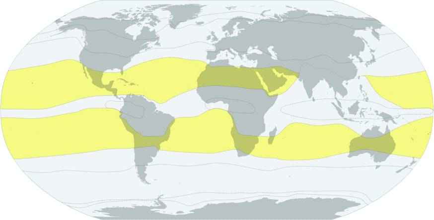
Tropical climate zone on the world map
The tropical climate zone covers separate territories in everything except Antarctica. An area of high pressure dominates the oceans all year round. Because of this, there is little rainfall in the climate zone. Summer temperatures in both hemispheres exceed +35°C. Average winter temperatures are +10°C. The average daily temperature fluctuation is felt in the interior of the continents.
Most of the time the weather is clear and dry. Most of the precipitation occurs during the winter months. Significant temperature fluctuations provoke dust storms. On the coasts, the climate is much milder: winters are warm, and summers are mild and humid. Strong winds are practically absent, precipitation falls in the calendar summer. The dominant natural areas are tropical forests, deserts and semi-deserts.
The tropical climate zone includes the following climate subtypes:
- trade wind climate;
- tropical dry climate;
- tropical monsoon climate;
- monsoon climate on tropical plateaus.
Subequatorial climate zone
Subequatorial climatic zone on the world map
The subequatorial climatic zone affects both hemispheres of the Earth. In summer, the zone is influenced by equatorial wet winds. In winter, the trade winds dominate. The average annual temperature is +28°C. Daily temperature fluctuations are insignificant. Most of the precipitation falls during the warm season under the influence of the summer monsoons. The closer to the equator, the more abundant it rains. In summer, most rivers overflow their banks, and in winter they dry up completely.
The flora is represented by monsoon mixed forests and light forests. The foliage on the trees turns yellow and falls during the drought period. With the arrival of rains, it is restored. In the open spaces of the savannas, cereals and herbs grow. The plant world adapted to periods of rain and drought. Some remote forest areas have not yet been studied by man.
Equatorial climate zone
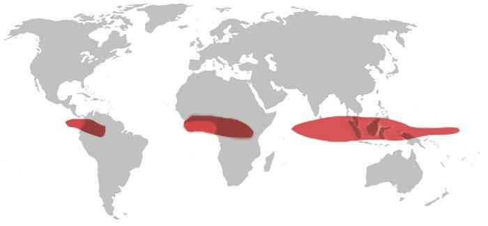
Equatorial climate zone on the world map
The belt is located on both sides of the equator. The constant flow of solar radiation creates a hot climate. Weather conditions are affected by air masses coming from the equator. The difference between winter and summer temperatures is only 3°C. Unlike other climatic zones, the equatorial climate remains virtually unchanged throughout the year. Temperatures do not fall below +27°C. Due to heavy rainfall, high humidity, fogs and clouds are formed. Strong winds are practically absent, which favorably affects the flora.
If you find an error, please highlight a piece of text and click Ctrl+Enter.